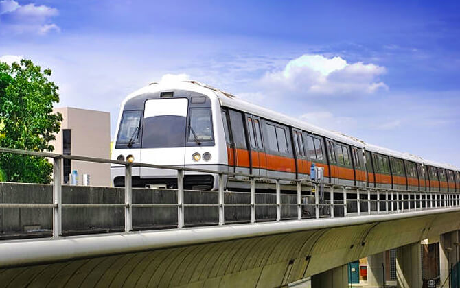
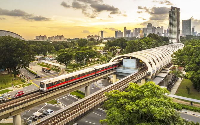
The Singapore Mass Rapid Transit, usually called the MRT, is the country’s main urban rail system and the backbone of public transport in Singapore. The first section opened on 7 November 1987 with five stations over 6 km (3.7 mi), and the network has grown into Southeast Asia’s oldest, busiest, and most extensive heavy rail metro system.
| Key | Information |
|---|---|
| System type | Heavy rail metro and core city transport network |
| Operational network | About 242.6 km (150.7 mi) |
| Operational lines | Six MRT lines |
| Operational stations | 143 stations |
| First opening | November 1987 |
| Future plan | About 460 km (286 mi) by 2040 |
| Operators | SMRT Trains and SBS Transit, under Land Transport Authority oversight |
| Network links | LRT, bus services, airport access, ferry points, and other transport connections |
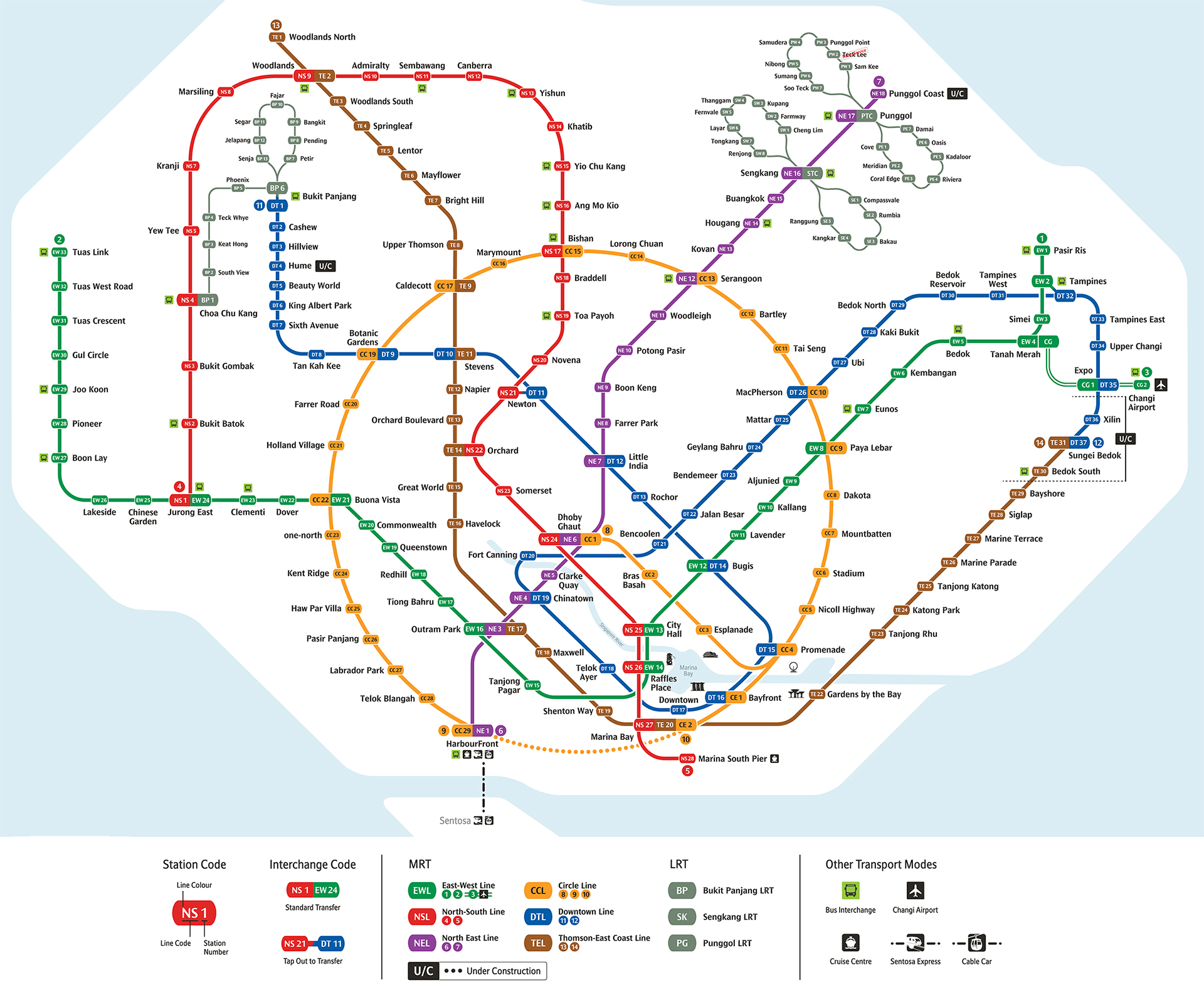
Singapore Mass Rapid Transit Map
Map of Singapore Mass Rapid Transit System showing different lines and stations. Click on the map to enlarge it or download the Singapore MRT map in PDF format.
Singapore MRT Lines and Stations
Singapore’s MRT network covers about 240 km (149 mi) and currently runs on six operational lines: the North–South Line, East–West Line, North East Line, Circle Line, Downtown Line, and Thomson–East Coast Line. Together, they form a circle-radial route plan with many interchange stations, making the system useful for daily commuting, airport travel, and sightseeing.
SMRT Trains operates the North–South, East–West, Circle, and Thomson–East Coast lines. SBS Transit operates the North East and Downtown lines. All 143 operational stations are wheelchair accessible, and many connect directly with bus interchanges, shopping areas, housing estates, or major destinations.
| Line | Route and stations |
|---|---|
| East–West Line | 35 stations, running from Pasir Ris to Tuas Link. At Tanah Merah, it branches to Changi Airport via the Changi Airport Extension. |
| North–South Line | 27 stations, running from Jurong East to Marina South Pier. |
| North East Line | 17 stations, running from HarbourFront to Punggol Coast. |
| Circle Line | 30 stations, running from Dhoby Ghaut to HarbourFront. The Circle Line Extension links Promenade to Marina Bay. |
| Downtown Line | 35 stations, running from Bukit Panjang to Expo. |
| Thomson–East Coast Line | 27 stations, running from Woodlands North to Bayshore. |
The stations list includes nine standalone terminal stations, 22 interchange stations, and six stations that are both terminal and interchange stations. Changi Airport station links to Terminals 2 and 3, while HarbourFront and Marina South Pier connect with ferry services. HarbourFront also connects with the Singapore Cable Car and Sentosa Express.
| Station | Details |
|---|---|
| Jurong East | Interchange for the North–South and East–West lines. |
| Dhoby Ghaut | Interchange for the North–South, North East, and Circle lines. |
| Outram Park | Interchange for the East–West, North East, and Thomson–East Coast lines. |
| Bayfront | Interchange for the Circle and Downtown lines. |
| Marina Bay | Interchange for the North–South, Circle, and Thomson–East Coast lines. |
Station codes appear with station names on the stations map and in route timetable information, helping passengers see each stop’s position on its line. Interchange stations may appear more than once in station listings because they serve more than one route.
The MRT continues to expand. The Jurong Region Line and Cross Island Line are under construction or planning, while future stations are also planned on existing lines, including Bukit Brown, Marina South, Mount Pleasant, and Tagore.
Operating Hours and Transfers
The Singapore MRT does not operate 24 hours a day. Typical operating hours run from around 5:30 AM to around midnight, although opening hours, opening times, and closing time vary by line, station, and day. If you need to transfer late at night, do not cut it too close.
| Service detail | Timings |
|---|---|
| Typical starting time | Around 5:30 AM on most lines |
| Typical working hours | From around 5:30 AM to around midnight |
| Many listed weekday timings | About 5:30 AM to 12:15 AM |
| Last train guidance | Usually around 11:45 PM to midnight, depending on the line and station |
| Transfer safety tip | Reach your starting station by about 11:45 PM if you still need to change trains |
| Holiday extensions | Selected services may run 1.5 to 2 hours later on major festive dates and public holiday eves |
For timings today, first train details, last train updates, and any service disruption, check MyTransport.SG or official operator notices before travelling. It is the safest way to confirm the train schedule for the route you plan to use.
MRT and bus journeys are integrated under the fare system. You can transfer between them without paying a new boarding fee if the transfer is completed within 45 minutes and the full journey ends within 2 hours. At most interchange stations, passengers pass through fare gates once on entry and once on exit for the whole trip.
Some transfers are especially easy. Cross-platform transfers are available at stations such as Jurong East, City Hall, and Raffles Place, where you can walk directly across the platform. At other stations, the path a train connection requires may involve longer corridors or escalators, so allow extra running time when changing routes.
Ticket Pricing and Purchase Options
Singapore MRT fare pricing is distance-based and regulated by the Public Transport Council. The fare system is designed to keep public transport affordable while covering operating costs, so the ticket price increases in stages as journey distance increases.
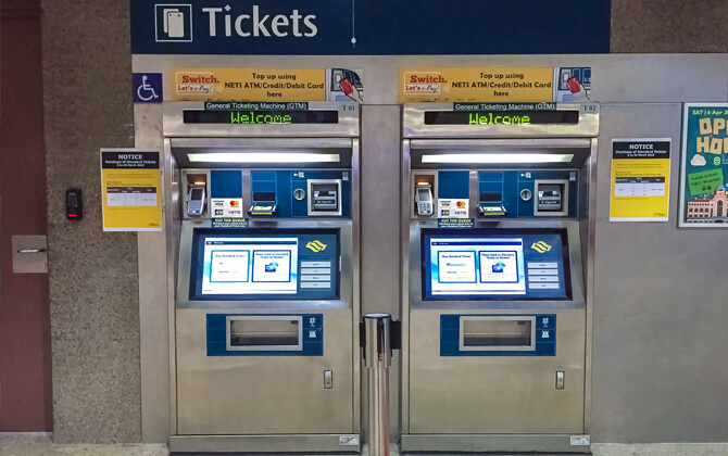
The MRT uses account-based ticketing and card-based ticketing. With account-based ticketing, the fare is calculated automatically after the trip and charged to the passenger’s linked account. With card-based ticketing, the system calculates the cost from the stored value on the card. In practice, the system works like a fare calculator at the gates: tap in, tap out, and the correct fare is applied.
- Stored-value travel cards such as EZ-Link and NETS FlashPay
- Contactless bank cards, including credit and debit cards
- Mobile wallets that support contactless payment
- Tourist pass options for unlimited travel within a limited period
Always use the same card or device when entering and exiting. If you use different cards, or fail to tap out, you may be charged the full fare or a flat fare. Fare evasion is subject to a penalty of S$50, about US$37.
| Option | What it is | Key notes |
|---|---|---|
| EZ-Link / NETS FlashPay | Stored-value travel cards | Can be used for MRT travel and may also be accepted for selected retail and transport-related payments. |
| Contactless bank cards | Credit or debit cards used through account-based ticketing | Fares are charged directly to the linked account. |
| Singapore Tourist Pass | Unlimited rides for a limited duration | Useful for visitors planning multiple trips in a short period. |
| Child Concession Card | Concessionary travel card | Available for eligible children. Children below 0.9 m (3 ft) travel free when accompanied, and children under 7 may travel free with the appropriate concession card. |
You can buy or top up travel cards at ticketing offices, station machines and kiosks, convenience stores where available, and selected SimplyGo Ticket Offices or visitor centres for tourist passes. Cashless payment is now the main method at most locations, as some older cash-based top-up options have been phased out.
Children under 4 and below 0.9 m (3 ft) travel free. Students, seniors, persons with disabilities, and workfare card holders may receive concession fares under the applicable eligibility rules.
Connections to Other Systems
The MRT is closely linked with other parts of Singapore public transport. It interchanges with the Light Rail Transit network in selected suburban towns, while LRT lines and bus services provide last-mile connections between MRT stations and nearby housing estates.
Fare collection is integrated through TransitLink, so commuters usually pay one combined fare for a journey, even when switching between lines operated by different companies. If a commuter extends a trip mid-journey, the fare difference is paid when exiting at the final destination.
Several MRT stations connect with non-rail transport too. Changi Airport station serves Terminals 2 and 3, Marina South Pier and HarbourFront connect with ferry services, and HarbourFront also links to the Singapore Cable Car and Sentosa Express.
Future connections will add more options to local transport. Woodlands North is expected to interchange with the Johor Bahru–Singapore Rapid Transit System from late 2026, while upcoming MRT projects are designed to strengthen transportation in Singapore across existing lines and new districts.
Airport Connectivity
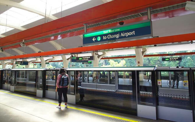
Changi Airport is directly connected to the MRT network through Changi Airport MRT station, an underground station on the East–West Line branch. The station sits between Terminals 2 and 3 and also provides access to airport facilities such as Jewel.
From the airport, take the East–West Line shuttle from Changi Airport station to Tanah Merah station, then transfer to services heading into the city. Another route is via Expo station and the Downtown Line, with a connection onward to Changi Airport station.
The airport station is operated by SMRT Trains and is currently the terminus of the Changi Airport branch. It is planned to become part of the Thomson–East Coast Line when that line is extended to the airport in the future.
| Service detail | Timings |
|---|---|
| Changi Airport MRT station opening hours | Daily from 5:10 AM to 12:10 AM |
| First and last train | Varies by day, so check the latest timetable before travelling |
Public buses also serve the airport terminals. Terminals 1, 2, and 3 are served by routes 24, 27, 34, 36, 53, 110, and 858. Terminal 4 is served by routes 24, 34, 36, and 110.
Metro Usage Guidelines
Using the Singapore MRT is simple, but a few rules matter. They help keep the system safe, orderly, and comfortable for everyone on board.
- Eating and drinking on trains is prohibited, including drinking water.
- Breastfeeding is allowed only after prior consultation with Metro staff.
- Accessing metro facilities under the influence of alcohol or narcotics is strictly prohibited.
- Illegal substances must not be carried in the metro.
- Forcibly opening train doors during a journey is punishable by a fine.
- Do not block other passengers from boarding a train.
- Physical or verbal assault on other passengers may result in a fine or imprisonment.
- Smoking is not allowed in stations or on trains.
- Chewing gum is banned in Singapore, so avoid chewing gum on the metro.
- Pets and other animals are not allowed on the Metro.
- Only folding bicycles are allowed on trains.
- Ordinary bicycles can be parked in bike racks provided at some stations.
- Photography and filming inside the Metro are permitted for non-commercial purposes.
For payment, ticket machines accept Samsung Pay and Apple Pay for ticket transactions. If you are travelling with a child, remember that student fares on the metro are different from those on buses, so check both before the trip.
Useful Tips
The MRT is easy to use once you know the basics. Keep your travel card, contactless bank card, or mobile wallet ready, follow line colors and station codes, and check the stations map before making a transfer at a busy interchange.
For a smoother ride, travel outside peak periods when possible. Weekday mornings and evenings are the busiest, and weekend shopping areas can also get crowded. If your trip is flexible, off-peak travel is usually more comfortable.
At stations, look for English signage, color-coded directions, and live train information screens. These help with the schedule today, route plan, platform direction, and next-train frequency. Many stations also connect directly to bus interchanges, malls, and major destinations.
Local etiquette is simple: let passengers alight first, keep noise low, and do not eat or drink on trains. On escalators, stand on the left and keep the right side clear for people walking past. Give priority seats to passengers who need them.
If you are new to the system, save an MRT map on your phone and use route planning tools before you travel. They are especially useful underground, where a quick check can help you choose the right platform, route timetable, and transfer path.
Distance-based fares make one card practical for most daily journeys. If you switch between bus and train within the transfer window, the fare is combined automatically, which keeps public transport simple for commuters and visitors.
History
The history of the Singapore MRT began with planning work in the 1960s. The idea emerged as the government looked for a comprehensive public transport system to serve a growing population and reduce long, inconvenient journeys in a city that then relied mainly on buses, taxis, and trishaws.
Studies and debates continued through the 1970s and early 1980s. In 1982, the MRT was approved and the Mass Rapid Transit Corporation was created to oversee construction and operations. Construction began in 1983, with the North–South Line given priority because it served Orchard Road, the Central Area, Toa Payoh, and Ang Mo Kio.
The first MRT section opened on 7 November 1987, when a 6 km (3.7 mi) stretch of the North–South Line between Yio Chu Kang and Toa Payoh entered service. More stations opened in stages, the East–West Line began operation in 1989, and the initial network was completed by 1990.
Expansion continued in the 1990s and 2000s. The Woodlands Extension opened on 10 February 1996, merging the Branch Line into the North–South Line. Later additions included the North East Line, Circle Line, Downtown Line, and infill stations such as Dover. The MRT also became integrated with the Light Rail Transit system, which first opened in 1999.
In 2000, the Mass Rapid Transit Corporation was privatised, with SMRT Corporation and SBS Transit becoming the main operators of different lines. Since the 2010s, the system has operated under a hybrid framework, with the Land Transport Authority responsible for construction and procurement.
The rolling stock has changed as well. The C151 train, introduced in 1987, was the first-generation EMU used on the MRT network. Its decommissioning began in 2020 as the R151 replaced it on the East–West Line and North–South Line.
The MRT map has changed with the network. In the late 1980s and early 1990s, the Branch Line appeared separately and was later merged with the North–South Line after the Woodlands Extension opened in 1996.
Future Extensions
Singapore’s MRT expansion continues through new lines, extensions, and long-term planning under the Land Transport Masterplan 2040. The network is projected to grow from about 242.6 km (150.7 mi) to around 460 km (286 mi) by 2040, strengthening rail connectivity across the city.
Several projects are already planned or under construction. The Thomson–East Coast Line is due to continue eastwards to Bayshore, with further work planned to reach Changi Terminal 5 in the mid-2030s. Circle Line Stage 6 will link Marina Bay and HarbourFront through Keppel, Cantonment, and Prince Edward Road, completing the loop in the first half of 2026.
The Downtown Line is also set for expansion to Sungei Bedok, while a later extension from Bukit Panjang to Sungei Kadut is planned for 2035. The Cross Island Line will become a major future backbone, with Phase 1 targeted for 2030, the Punggol Extension for 2032, and Phase 2 planned for the early 2030s. Phase 3 is expected to follow later, although detailed alignment plans have not yet been announced.
Other confirmed projects include two new North–South Line stations, Brickland and Sungei Kadut, expected in 2034 and 2035. Feasibility studies are also ongoing for possible future lines such as the Seletar Line and the Tengah Line, which may eventually be linked depending on planning outcomes.
Future MRT development focuses on bringing stations closer to homes, new districts, and transport interchanges, while complementing the LRT system and bus network for last-mile connectivity.
Tourist Attractions
Singapore is compact, so the MRT is one of the easiest ways to see many attractions in a short time. The East–West Line is especially useful for a simple sightseeing route from Changi Airport in the east to Tuas Link in the far west, with neighborhoods, shopping areas, and landmarks close to stations along the way.
| Station | Details |
|---|---|
| Changi Airport | A useful starting point, with airport gardens, a free cinema, and a swimming pool for visitors. |
| Paya Lebar | Good for Malay heritage and Peranakan culture, with Geylang Serai Market nearby. |
| Bugis | Close to Kampong Gelam, Sultan Mosque, independent boutiques, cafés, and street art. |
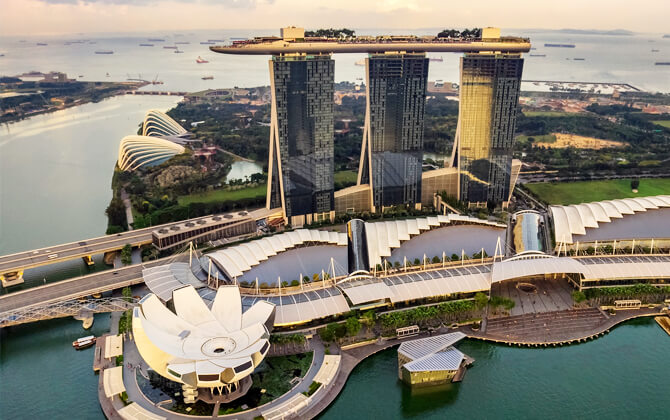
| City Hall | A central stop for landmarks such as the Esplanade, Marina Bay Sands, and the Merlion. |
| Outram Park | A convenient starting point for Chinatown and nearby heritage areas. |
| Tiong Bahru | Known for pre-war flats, indie shops, cafés, and a hawker centre. |
| Queenstown | One of Singapore’s oldest public housing estates, with walking routes and local history. |
| Chinese Garden | A green stop for Jurong Lake Gardens and nearby attractions such as the Singapore Science Centre. |
| Tuas Link | The western end of the line, near Raffles Marina and a lighthouse with a view of the Second Link Causeway. |
Beyond the East–West Line, other stations place major sights within easy reach. City Hall and Raffles Place connect to the downtown core, Dhoby Ghaut is close to the National Museum of Singapore, Bayfront serves Gardens by the Bay, and Botanic Gardens gives access to the Singapore Botanic Gardens.
For families, nature lovers, and shoppers, stations such as Jurong East, Bishan, Toa Payoh, and Woodlands also connect directly to parks, malls, and local neighborhoods. Staying near an MRT station makes sightseeing easier, especially with distance-based fares, frequent trains, and a wide network of interchanges.