The Tyne and Wear Metro is an overground and underground light rail rapid transit system serving Newcastle upon Tyne, Gateshead, North Tyneside, South Tyneside, and the City of Sunderland. Owned and operated by Nexus, it is a publicly run public transport system with two lines, 60 stations, and 77.5 km (48.2 mi) of track. The Metro opened in stages from August 1980, later expanded to Newcastle Airport in 1991 and to Sunderland and South Hylton in 2002, and now forms a key part of city transport and local transport across Tyne and Wear.
| Key | Information |
|---|---|
| System type | Overground and underground light rail rapid transit |
| Operator | Nexus, the Tyne and Wear Passenger Transport Executive |
| Ownership | Fully public ownership and operation |
| Area served | Newcastle upon Tyne, Gateshead, North Tyneside, South Tyneside, and Sunderland |
| Lines | Green line and Yellow line |
| Stations | 60 stations |
| Network length | 77.5 km (48.2 mi) |
| First opened | August 1980 |
| Airport route | Opened to Newcastle Airport in 1991 |
| Latest fleet update | First Class 555 train entered passenger service on 18 December 2024 |
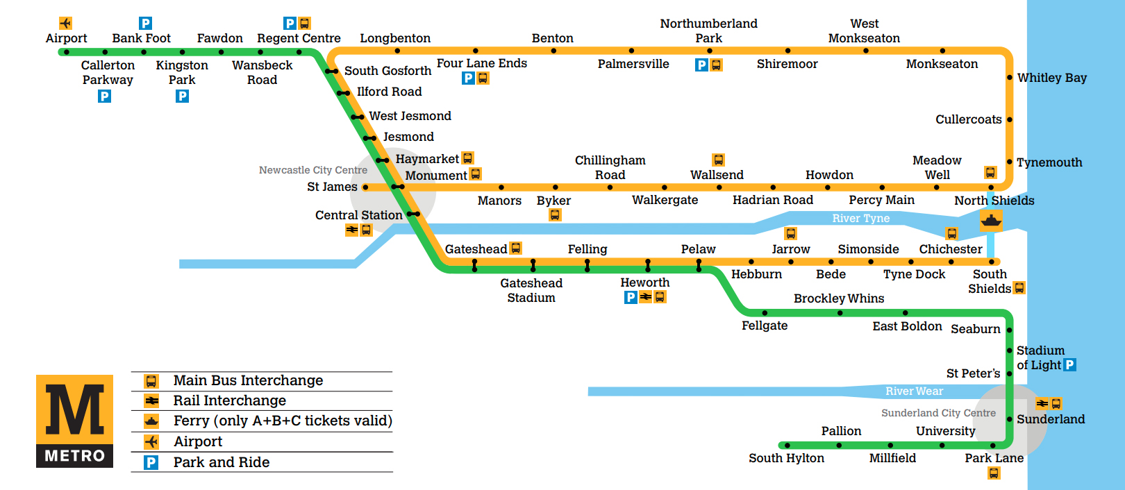
Map of Newcastle Tyne and Wear Metro
Map of Newcastle Metro showing different lines. Click on the map to enlarge it or download the Newcastle (Tyne and Wear) Metro map in PDF format.
Lines and Stations
The Tyne and Wear Metro route plan is built around two service lines: the Green line and the Yellow line. Together, they cover 60 stations across Tyne and Wear, with a mix of purpose-built Metro stops and stations converted from earlier railway routes.
Most stations are at surface level, but several central stations are underground, including Central, Jesmond, Haymarket, Monument, Manors, St James, and Gateshead. Park Lane in Sunderland is also listed as underground, and Sunderland station has platforms covered by the station building.
Three stations interchange with National Rail services in the core information provided for the network: Central, Heworth, and Sunderland. The stations map also shows how both Metro lines share a central section, giving higher train frequency through the busiest part of the system.
Green line
The Green line runs between South Hylton and Airport. It is the main Metro route for Newcastle International Airport and also serves Sunderland, Gateshead, central Newcastle, and the north-western suburbs.
| Station | Details |
|---|---|
| South Hylton | Green line terminal with one platform |
| Pallion | Green line station |
| Millfield | Green line station |
| University | Green line station in Sunderland |
| Park Lane | Underground Green line station in Sunderland |
| Sunderland | Green line station with National Rail interchange |
| St Peter’s | Green line station |
| Stadium of Light | Green line station |
| Seaburn | Green line station |
| East Boldon | Green line station |
| Brockley Whins | Green line station |
| Fellgate | Green line station |
| Pelaw | Shared section begins toward central Newcastle |
| Heworth | Interchange with National Rail services |
| Felling | Green and Yellow line station |
| Gateshead Stadium | Green and Yellow line station |
| Gateshead | Underground station |
| Central | Underground station with National Rail interchange |
| Monument | Central interchange with four platforms on two separate lines |
| Haymarket | Underground station in central Newcastle |
| Jesmond | Underground station |
| West Jesmond | Green and Yellow line station |
| Ilford Road | Green and Yellow line station |
| South Gosforth | Shared central section ends toward Airport |
| Regent Centre | Green line station and bus interchange |
| Wansbeck Road | Green line station |
| Fawdon | Green line station |
| Kingston Park | Green line station |
| Bank Foot | Green line station |
| Callerton Parkway | Next station from Airport toward the city |
| Airport | Green line terminal serving Newcastle International Airport |
Green line trains usually run up to every 12–15 minutes. The starting time is generally between 05:00 and 06:00 on weekdays and between 06:00 and 07:00 on Saturdays and Sundays. Extra trains also operate between Pelaw and Monkseaton at peak times.
Yellow line
The Yellow line runs between South Shields and St James via Whitley Bay. Its path takes passengers through coastal stations, central Newcastle, Gateshead, and South Tyneside.
| Station | Details |
|---|---|
| South Shields | Yellow line terminal with one platform |
| Chichester | Yellow line station |
| Tyne Dock | Yellow line station |
| Simonside | Yellow line station |
| Bede | Yellow line station |
| Jarrow | Yellow line station |
| Hebburn | Yellow line station |
| Pelaw | Shared section toward central Newcastle |
| Heworth | Interchange with National Rail services |
| Felling | Green and Yellow line station |
| Gateshead Stadium | Green and Yellow line station |
| Gateshead | Underground station |
| Central | Underground station with National Rail interchange |
| Monument | Major city-centre interchange |
| Haymarket | Underground station in central Newcastle |
| Jesmond | Underground station |
| West Jesmond | Green and Yellow line station |
| Ilford Road | Green and Yellow line station |
| South Gosforth | Shared central section ends toward the coast |
| Longbenton | Yellow line station with 1930s design influence |
| Four Lane Ends | Yellow line station and bus interchange |
| Benton | Yellow line station |
| Palmersville | Yellow line station |
| Northumberland Park | Yellow line station with rail connections listed in network information |
| Shiremoor | Yellow line station |
| West Monkseaton | Yellow line station with 1930s design influence |
| Whitley Bay | Coastal Yellow line station |
| Cullercoats | Coastal Yellow line station |
| Tynemouth | Coastal Yellow line station |
| North Shields | Yellow line station with three platforms, including one bay platform |
| Meadow Well | Yellow line station |
| Percy Main | Yellow line station |
| Howdon | Yellow line station |
| Hadrian Road | Yellow line station |
| Wallsend | Yellow line station |
| Walkergate | Yellow line station |
| Chillingham Road | Yellow line station |
| Byker | Yellow line station |
| Manors | Underground station |
| Monument | Served again by the Yellow line on a different platform pattern |
| St James | Yellow line terminal in central Newcastle |
The Yellow line also runs up to every 12–15 minutes. Between Pelaw and South Gosforth, where both lines share track, the combined frequency is usually every 6–8 minutes.
Stations
The stations list includes a wide range of designs. Some stations kept Victorian railway character, others were purpose-built for the Metro, and Longbenton and West Monkseaton show 1930s design influences. The Sunderland extension, opened in the early 2000s, added another architectural layer to the network.
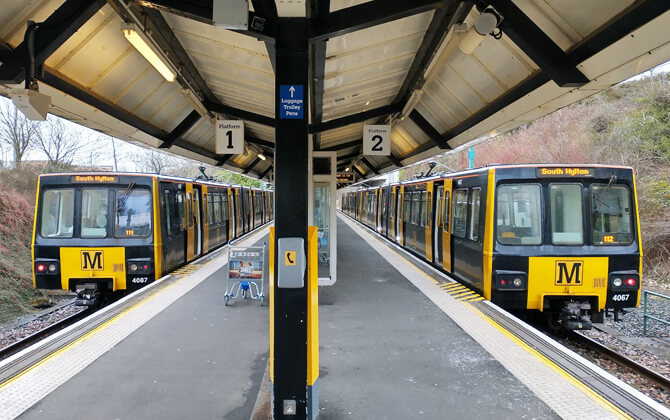
Most stations have two platforms. South Hylton and South Shields have one platform each, North Shields has three platforms including a bay platform, and Monument has four platforms on two separate lines.
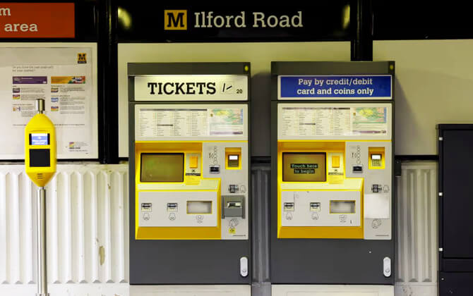
Every station has ticket machines, shelters, information displays, next-train indicators, and passenger information or emergency help-points. Stations are unstaffed except the underground stations, which must be staffed by law.
Operating Hours and Frequency
Tyne and Wear Metro operating hours usually begin between 05:00 and 06:00 on weekdays, and between 06:00 and 07:00 on Saturdays and Sundays. Frequent services continue until around midnight, so the closing time is generally close to 00:00, though passengers should always check the train schedule for the last train before travelling late.
| Service detail | Timings |
|---|---|
| Weekday opening hours | Services generally start between 05:00 and 06:00 |
| Saturday and Sunday opening times | Services generally start between 06:00 and 07:00 |
| Daytime frequency | Up to every 12 minutes on most days |
| Evening frequency | Up to every 15 minutes |
| Sunday working hours | Every 15 minutes across the day |
| Central shared section | Every 6–8 minutes between Pelaw and South Gosforth |
| Peak running time pattern | Additional weekday short workings can increase service to about every 3 minutes on the busiest section |
| Closing time and last train | Services continue until around midnight |
| Main timetable change | December |
| Smaller timetable change | May |
The route timetable changes during the year, mainly in December with a smaller update in May. For schedule today, timings today, and late-night travel, check the current timetable before you set off, especially if you are relying on the last train.
Fares, Tickets, and Cards
Tyne and Wear Metro fare levels are zone-based. Tickets are sold from machines at all stations, and the ticket price depends on how many zones you cross. A simple fare calculator approach is to count your zones first, then choose the matching ticket or pass.
| Ticket | Price |
|---|---|
| Single ticket, 1 zone | £1.80, about $2.25 |
| Single ticket, 2 zones | £2.70, about $3.40 |
| Single ticket, 3 zones | £3.40, about $4.25 |
| Metro Day Pass, 1 zone | £2.70, about $3.40 |
| Metro Day Pass, 2 zones | £3.70, about $4.65 |
| Metro Day Pass, 3 zones | £4.60, about $5.75 |
| Day Rover | £6.90, about $8.65 |
| Transfare T1, 1 zone | £2.80, about $3.50 |
| Transfare T2, 2 zones | £3.60, about $4.50 |
| Transfare T3, 3 zones | £4.30, about $5.40 |
| Child single fare with Under 16 Pop Card | 60p, about $0.75 |
| Some Metro Park and Ride parking charges per day | £1.60, about $2.00 |
A single ticket is valid for 90 minutes after purchase and can be used for a continuous journey on the Metro or local rail between Newcastle and Sunderland. For one day of unlimited travel, the Metro Day Pass covers Metro, ferries, and trains in the selected zones.
Adult Day Tickets are available for passengers making more than one single or return journey in a day on the Metro or on buses from different operators. The Day Rover offers unlimited travel within Tyne and Wear for one day and is useful when your route plan includes several modes of transport.
Transfare tickets are designed for a two-leg journey using different forms of public transport. The second leg must start within 90 minutes of purchase, and only one ticket is needed.
Family and group tickets are available for two adults and up to three children under 14, allowing unlimited one-day travel within Tyne and Wear and beyond. Children under five travel free, and children with an Under 16 Pop Card pay the reduced child fare.
The Pop Pay As You Go smart card can be topped up at stations and used as you travel. Pop cards also work on buses and ferries. Ticket machines accept credit cards, debit cards, contactless payment, notes, and coins.
Travelling without a valid ticket can lead to a penalty fare or further enforcement, so buy before you board. For station parking, most park and ride facilities are free through the summer, although some Metro Park and Ride sites charge £1.60 per day, about $2.00.
Connections to Other Systems
The Tyne and Wear Metro is closely linked with other transport systems, which makes it a central part of transportation in Tyne and Wear. Direct interchange with National Rail is available at several stations, including Central, Heworth, Manors, Northumberland Park, and Sunderland. At Sunderland, Metro and heavy rail services share platforms, a rare arrangement in the United Kingdom.
The Metro also connects with the Shields Ferry, which links North Shields and South Shields across the River Tyne. This is handy for Yellow line journeys where the ferry can shorten a cross-river trip.
From the start, the Metro was planned as part of an integrated public transport system. Local bus services were intended to feed passengers into major interchanges such as Four Lane Ends, Heworth, and Regent Centre. That original bus integration ended after deregulation in 1986, but bus and rail links remain important across the network.
Between Pelaw and Sunderland, Metro trains use a shared section with Network Rail, running alongside heavy rail services on adapted infrastructure. This gives the system a stronger connection to regional rail than many urban light rail networks.
Airport Connections
The Tyne and Wear Metro gives Newcastle International Airport a direct rail link on the Green line. Airport station opened in November 1991 as part of the extension from Bank Foot, and it serves the airport terminal building.
Trains run between Airport and South Hylton, with Airport at the end of the Green line. On the network map, Callerton Parkway is the next stop toward the city, followed by stations such as Bank Foot, Kingston Park, Fawdon, Wansbeck Road, Regent Centre, South Gosforth, Jesmond, Haymarket, Monument, Gateshead, and Sunderland along the wider route.
Airport station has an island platform, and all stations on the line have step-free access. For visitors arriving by air, the Metro is a direct public transport route into Newcastle city centre and onward across the Tyne and Wear network.
System Regulations
The Tyne and Wear Metro is a publicly owned light rapid transit system operated by Nexus. Its regulatory setup is distinctive because some parts of the network are exempt from certain rail access provisions, while shared sections have different access and licensing requirements.
Accessibility is central to the system. The Metro was designed with step-free access at all stations, and annual surveys check platform gap and height dimensions. Manual boarding ramps are available for passengers who request them in advance.
The Metro has also received exemptions from some accessibility standards for existing rolling stock. These reflect platform and vehicle dimensions, practical limits on the current network, and the planned replacement of older trains with new RVAR-compliant trains.
Safety regulation falls under the Railways and Other Guided Transport Systems (Safety) Regulations 2006. Nexus holds the safety authorisation needed for the stations, infrastructure, and Metro system it operates.
For the shared-network expansion linked to Metro Flow, regulation is more complex. Shared sections are subject to access and licensing arrangements overseen by the Office of Rail and Road, while the existing Metro network continues under its established exemption framework.
Passengers must follow fare and safety rules. Ticket checks take place regularly, and travelling without a ticket can lead to a penalty fare. Bicycle use is restricted on some parts of the network, while folding bikes are permitted when safely folded.
History
The history of the Tyne and Wear Metro begins with much older suburban railway routes around Tyneside. The system reused parts of the former Tyneside Electrics network, which began electrifying local routes in 1904, and some infrastructure with roots in the 19th century.
Predecessors
The present network uses former railway lines associated with the Newcastle and North Shields Railway, the Blyth and Tyne Railway, the Brandling Junction Railway, the Ponteland Railway, the Durham Coast Line, and the Penshaw Branch. In the 1960s, British Rail de-electrified the Tyneside Electrics and switched services to diesel operation, a move widely seen as a backward step because the diesel trains were slower than the electric stock they replaced.
Planning and construction
In the early 1970s, poor local transport was identified as a serious problem for the regional economy. A 1971 study commissioned by the Tyneside Passenger Transport Authority recommended converting the worn-down former Tyneside Electrics into an electrified rapid transit system, with a new underground section serving central Newcastle and Gateshead more effectively.
The plans were approved by the Tyneside Metropolitan Railway Act 1973, and construction began in 1974. The original scheme converted three railway lines and added around 9.7 km (6 mi) of new infrastructure, including tunnels, bridges, and elevated sections.
Major works included the Queen Elizabeth II Bridge over the River Tyne and the Byker Viaduct across the Ouseburn Valley. The project also re-electrified routes with overhead lines, upgraded existing stations, and built new stations, including underground stops. Step-free access was part of the design from the beginning.
Opening
The first Metro section opened in August 1980, and the original network was completed in March 1984. Services opened in stages, starting with the route between Haymarket and Tynemouth, then extending across Newcastle, Gateshead, and South Tyneside.
Early services were integrated with local buses as part of a planned public transport network, with buses feeding passengers into Metro interchanges. That arrangement ended after bus deregulation in 1986.
Expansion and later development
The first major expansion of the original system opened in November 1991, when the Metro reached Newcastle Airport. A further extension from Pelaw to Sunderland and South Hylton opened in March 2002, using part of the Durham Coast Line and becoming the first system in the United Kingdom to implement a form of the Karlsruhe model.
By 2013, the network had grown to 60 stations across two lines, covering 77.5 km (48.2 mi) of track. Nexus has usually operated the Metro directly, although DB Regio ran the system under a concession from 2010 to 2017 before operation returned to Nexus.
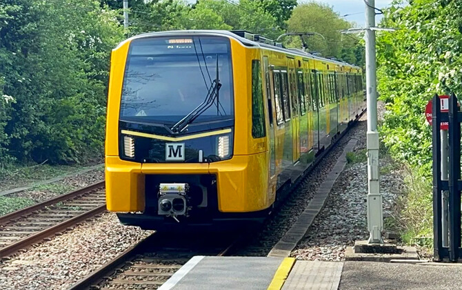
From 2016, Nexus began replacing the 1980s rolling stock. Under the Metro Flow scheme announced in 2020, investment was planned to increase service frequency, reduce journey times, and improve reliability. The first replacement Class 555 train entered passenger service on 18 December 2024.
Future expansions
The clearest future expansion for the Tyne and Wear Metro is the planned extension to Washington. The proposal would use part of the former Leamside Line to link Pelaw and South Hylton via Washington, with new stations planned at Follingsby, Washington North, and Washington South.
The scheme is expected to cost about £900 million, roughly $1.13 billion, and has been presented as an important step toward wider rail re-opening in the region. In November 2022, the first stages of a business case were published, with funding support later announced by the North East Combined Authority and the Mayor of the North East.
In June 2025, additional public transport funding was confirmed for the region, with £900 million, about $1.13 billion, intended for the Washington extension once planning is complete. Remaining funding is expected from private investment, and the targeted opening date is 2033.
Other expansion ideas have been discussed but remain unconfirmed. These include wider use of the Leamside Line, possible new stations in central Gateshead and the Quays, improvements to public transport in the west end of Newcastle, better links to the Northumberland Line, and new or improved services on the East Coast Main Line.
Tips
A smoother Metro trip usually comes down to simple habits. They help keep the train safe, comfortable, and easy to use, especially during busy working hours.
- Keep luggage between your legs or in front of you when standing. Do not place bags on seats.
- Keep your feet off the seats and avoid sitting in a way that creates a trip hazard.
- Do not vape on trains or station premises. If you need to vape, do it outside the station and dispose of it properly.
- Keep language and tone respectful, particularly around children and other passengers.
- Be polite to Metro staff and other customers. It makes a crowded journey feel much easier.
- Let passengers off the train before you board.
- Keep noise down, including music, videos, and phone conversations. Use headphones if you are listening to something.
- Do not drink alcohol on Metro premises or on the trains.
Interesting facts
Nexus has described the Tyne and Wear Metro as Britain’s first light rapid transit system. Although visitors sometimes compare it with trams or a tramway, it operates as a light rail rapid transit network with both underground and overground sections.
Much of the system was created by reusing older railway infrastructure, including parts of the former Tyneside Electrics network. Some sections trace their origins back to 1834, long before the Metro name appeared.
The Metro was the first railway in the United Kingdom to operate using the metric system, with speeds and distances stated only in metric units. It was also designed for accessibility from the start, with step-free access at all stations.
Notable engineering works include the Queen Elizabeth II Bridge over the River Tyne and the Byker Viaduct across the Ouseburn Valley. Under Newcastle, the path train pattern is especially unusual at Monument, where Yellow line trains pass through the station twice on different platforms.
When the Metro opened, it was meant to work with local buses as an integrated transport network. Bus deregulation in 1986 ended the original feeder arrangement, but Transfare tickets still support trips using more than one mode.
The system expanded to Newcastle Airport in 1991 and to Sunderland and South Hylton in 2002. The Sunderland extension introduced shared Metro and heavy rail running, making it the first United Kingdom system to use a form of the Karlsruhe model.
The Metro identity is strongly linked to the Calvert typeface and the black M logo on a yellow background. The network also includes a rare pretzel configuration, where a line crosses over itself and trains pass through the same station twice on different platforms.
Passenger numbers peaked at 59.1 million in 1985–86, later fell after bus deregulation, and then stabilised at around 35 to 40 million journeys a year before dropping sharply during the COVID-19 pandemic.
Sightseeing via the Newcastle upon Tyne Metro
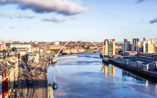
The Newcastle upon Tyne Metro is a practical way to explore Tyne and Wear, from central Newcastle to the coast and across to Sunderland. Because the route is partly underground and partly overground, the ride itself adds to the experience.
In Newcastle city centre, useful stations include St James, Monument, Haymarket, Jesmond, and Central. The underground stations make it easy to move quickly between central sights while staying connected to the wider transport network.
Heading north, the Metro route reaches coastal places such as Tynemouth, Whitley Bay, and North Shields. This is one of the best reasons to use the Metro for a day out: city streets, seaside walks, and coastal views sit on the same system.
South of the Tyne, the Metro reaches South Shields and Sunderland. Part of the network shares track with National Rail services, so it can be useful for linking different parts of the region on a single ticket.
Highlights often associated with a Metro day out include:
- Newcastle city centre and its underground stations
- The coast around Tynemouth and Whitley Bay
- South Shields and the riverside route
- Sunderland and the shared rail section
- Stations connected with local history and former railway alignments
A day pass is a simple option if you want to combine city walks, coastal scenery, and station-hopping in one trip.
Hello
Can you tell me how long it takes to get from heworth metro to the airport , which line it is and how often the journey takes and can you pay on the train. Thanks very much. Chris