The Yokohama Municipal Subway is a rapid transit system serving Yokohama in Kanagawa Prefecture, Japan. Operated by the Yokohama City Transportation Bureau, it is a key part of public transport and local transport in the city, with two active routes: the Blue Line and the Green Line. Together they cover about 53.4 km (33.2 mi) and serve 42 stations. Officially, the system includes Line 1, Line 3, and Line 4; Lines 1 and 3 run together as the Blue Line, while Line 4 operates as the Green Line.
| Key | Information |
|---|---|
| System | Yokohama Municipal Subway |
| Operator | Yokohama City Transportation Bureau |
| City | Yokohama, Kanagawa Prefecture, Japan |
| Lines | Blue Line and Green Line |
| Total length | About 53.4 km (33.2 mi) |
| Stations | 42 stations |
| Main transfers between subway lines | Center-Kita and Center-Minami |
| Role in city transport | Connects central Yokohama with northern, southern, and New Town areas |
Yokohama Municipal Subway Map
Map of Yokohama Municipal Subway showing different lines and stations. Click on the map to enlarge it or download the Yokohama Municipal Subway map in PDF format.

Yokohama Municipal Subway Lines and Stations
The Yokohama Municipal Subway route plan is built around two active routes. The Blue Line runs from Shonandai to Azamino and is the longer route, while the Green Line runs from Nakayama to Hiyoshi. There is no Line 2, because that planned route was never built.
The Blue Line connects central Yokohama with the northern and southern parts of the city. Major interchange stations include Yokohama, Shin-Yokohama, Kannai, Kami-Ooka, Totsuka, and Shonandai. The Green Line links the northern New Town area on an east-west path, with transfers to the Blue Line at Center-Minami and Center-Kita.
Station numbering helps when reading a stations map or checking a stations list. Blue Line stations use B01 to B32, and Green Line stations use G01 to G10. At Center-Minami and Center-Kita, each line has its own station number.
| Line | Termini | Stations | Length |
|---|---|---|---|
| Blue Line | Shonandai – Azamino | 32 | 40.4 km (25.1 mi) |
| Green Line | Nakayama – Hiyoshi | 10 | About 13.0 km (8.1 mi) |
| Total | Blue Line and Green Line | 42 | About 53.4 km (33.2 mi) |
Shonandai is the only station on the network located outside Yokohama city; it is in Fujisawa, Kanagawa. The subway serves most of Yokohama, except Seya and Sakae wards.
The Blue Line stations list is shown below.
| Station | Details |
|---|---|
| B32 Azamino | Blue Line terminus; connection to the Den-en-toshi Line |
| B31 Nakagawa | Blue Line station |
| B30 Center-Kita | Transfer to the Green Line |
| B29 Center-Minami | Transfer to the Green Line |
| B28 Nakamachidai | Blue Line station |
| B27 Nippa | Blue Line station |
| B26 Kita Shin-Yokohama | Blue Line station |
| B25 Shin-Yokohama | Connection to the Tokaido Shinkansen and JR Yokohama Line |
| B24 Kishine-koen | Blue Line station |
| B23 Katakuracho | Blue Line station |
| B22 Mitsuzawa-kamicho | Blue Line station |
| B21 Mitsuzawa-shimocho | Blue Line station |
| B20 Yokohama | Major rail interchange and connection to the Minatomirai Line |
| B19 Takashimacho | Blue Line station |
| B18 Sakuragicho | Connection to the JR Negishi Line |
| B17 Kannai | Connection to the JR Negishi Line |
| B16 Isezakichojamachi | Blue Line station |
| B15 Bandobashi | Blue Line station |
| B14 Yoshinocho | Blue Line station |
| B13 Maita | Blue Line station |
| B12 Gumyoji | Blue Line station |
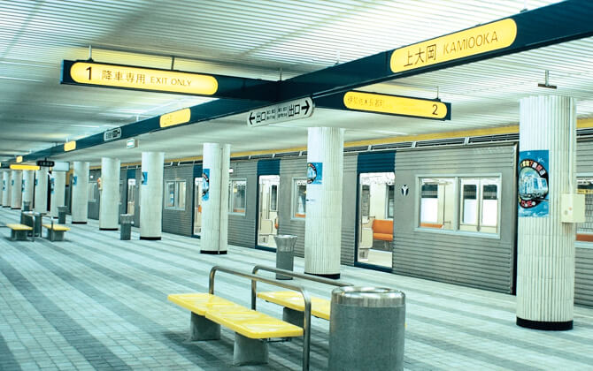
| B11 Kami-Ooka | Connection to the Keikyu Main Line |
| B10 Konan-Chuo | Blue Line station |
| B09 Kaminagaya | Blue Line station |
| B08 Shimonagaya | Blue Line station |
| B07 Maioka | Blue Line station |
| B06 Totsuka | Connection to the Shonan-Shinjuku Line, Tokaido Main Line, and Yokosuka Line |
| B05 Odoriba | Blue Line station |
| B04 Nakada | Blue Line station |
| B03 Tateba | Blue Line station |
| B02 Shimoiida | Blue Line station |
| B01 Shonandai | Blue Line terminus; connection to the Odakyu Enoshima Line and Sotetsu Izumino Line |
The Green Line stations list is shorter and runs from Nakayama to Hiyoshi.
| Station | Details |
|---|---|
| G01 Nakayama | Green Line terminus; connection to the JR Yokohama Line |
| G02 Kawawacho | Green Line station |
| G03 Tsuzuki-fureainooka | Green Line station |
| G04 Center-Minami | Transfer to the Blue Line |
| G05 Center-Kita | Transfer to the Blue Line |
| G06 Kita-Yamata | Green Line station |
| G07 Higashi-Yamata | Green Line station |
| G08 Takata | Green Line station |
| G09 Hiyoshi-Honcho | Green Line station |
| G10 Hiyoshi | Green Line terminus; connection to the Tokyu Toyoko Line and Tokyu Meguro Line |
Schedule and timetables
Yokohama Municipal Subway operating hours run from early morning until after midnight. The starting time is before 5:30 a.m., and service continues past 12:30 a.m. on the main timetable, though exact opening times, working hours, last train times, and closing time depend on the line and day of the week.
Passengers can check the route timetable, train schedule, schedule today, and timings today using the official timetable and route search tools. These tools also show travel time, fare, commuter pass prices, and route options when you choose boarding and alighting stations.
| Service detail | Timings |
|---|---|
| Overall subway service | Daily service begins before 5:30 a.m. and ends after 12:30 a.m., depending on line and day |
| Blue Line first train | First train from Azamino at 5:14 a.m. |
| Blue Line last train | 12:49 a.m. on weekdays; 12:19 a.m. on weekends |
| Blue Line frequency | About every 9 minutes early on weekdays, 6 to 8 minutes from around 6:00 a.m., every 4 minutes during the morning peak until 9:00 a.m., about every 7 minutes from 9:00 a.m. to 4:00 p.m., every 5 to 6 minutes in the late afternoon, and about every 12 minutes late at night |
| Green Line first train | First train from Hiyoshi at 5:15 a.m. Monday to Friday and 5:14 a.m. on weekends |
| Green Line last train | 12:40 a.m. on weekdays; 12:28 a.m. on weekends |
| Green Line frequency | Every 10 minutes at the start of service, then every 6 minutes, then every 4 minutes around the morning rush from about 7:00 a.m.; service becomes more stable after 8:00 a.m. and slows to every 12 minutes around 11:00 p.m. |
For the most accurate timetable before you travel, check the current station timetable. It is the safest way to confirm whether trains still run close to the end of service.
Tariffs, tickets and cards
Yokohama Municipal Subway uses a distance-based fare system. You can travel with a regular ticket, a one-day pass, a commuter pass, an IC card such as PASMO or Suica, or a contactless payment-enabled card or smartphone. Approximate US dollar amounts below are rounded.
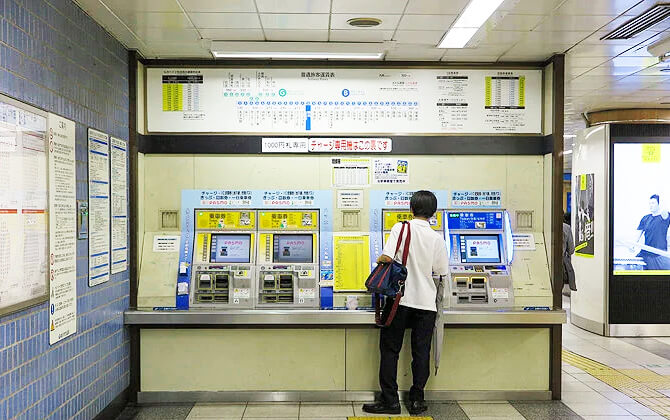
The adult base fare is 210 yen, about US$1.40, for the first 3 km (1.9 mi). Child fares are half the adult price. Ticket machines at all subway stations sell regular tickets, and fare tables above the machines show station fares in Japanese and English.
For municipal buses, the standard fare is 220 yen, about US$1.47, for adults and 110 yen, about US$0.73, for children. On line 40, the cost is calculated by distance.
| Ticket or pass | Adult price | Child price | Details |
|---|---|---|---|
| Regular subway ticket | From 210 yen, about US$1.40 | Half the adult fare | Distance-based ticket price from ticket machines |
| One-Day Subway Pass | 740 yen, about US$4.93 | 370 yen, about US$2.47 | Unlimited rides on the Blue Line and Green Line for one day |
| Subway & Bus One Day Pass | 830 yen, about US$5.53 | 420 yen, about US$2.80 | Covers all city bus routes and all Yokohama Municipal Subway stations |
| Minato Burari Ticket | 700 yen, about US$4.67 | 350 yen, about US$2.33 | One-day sightseeing ticket for the bay area |
| Minato Burari Ticket Wide | 750 yen, about US$5.00 | 380 yen, about US$2.53 | Wider one-day sightseeing ticket for the bay area |
| Yokohama-Minatomirai Pass | 530 yen, about US$3.53 | 260 yen, about US$1.73 | Pass for JR East trains in the Yokohama area |
The One-Day Subway Pass is useful if you plan to ride the subway several times in a day. The Subway & Bus One Day Pass is better when your route combines the subway with city buses.
You can buy one-day passes at subway ticket machines for immediate use. Advance purchase is available at customer service centers at Center-Minami Station, Shin-Yokohama Station, Yokohama Station, and Kamiooka Station. The combined subway and bus pass can also be bought on board buses or at bus pass counters at city bus terminals.
PASMO and Suica are accepted on the Yokohama Municipal Subway. Touch the card at the ticket gate when entering and leaving. Ticket machines can also sell PASMO cards and top up your balance; they include English guidance and accept banknotes and coins.
Contactless payment-enabled credit, debit, and prepaid cards can be used at automatic ticket gates, as can smartphones set up with those cards. No prior registration is required.
If you need to compare ticket price, commuter pass price, or total trip cost, use the route search as a fare calculator before entering the gate.
| Commuter pass type | 1 month | 3 months | 6 months |
|---|---|---|---|
| Work commuter pass | 9,900 yen, about US$66.00 | 28,220 yen, about US$188.13 | 53,460 yen, about US$356.40 |
| School commuter pass, junior high school and above | 6,920 yen, about US$46.13 | 19,720 yen, about US$131.47 | 37,370 yen, about US$249.13 |
| School commuter pass, elementary school and under | 2,230 yen, about US$14.87 | 6,360 yen, about US$42.40 | 12,040 yen, about US$80.27 |
Commuter passes are available for work and school use on Yokohama Municipal Bus services, except the sightseeing bus Akai Kutsu. To buy a commuter pass, you need documents confirming eligibility. Junior high school students and younger need proof of identity, such as a health insurance card or student ID. Senior high school students and above need a certificate of school commutation or a student ID.
Connections with Other Systems
Yokohama is served by two subway systems: the Yokohama Municipal Subway and the Minatomirai 21 Line. Inside the municipal subway system, the Blue Line and Green Line connect at Center-Kita and Center-Minami, so changing routes is straightforward.
The Blue Line has the widest range of rail connections. At Shin-Yokohama, passengers can transfer to the Tokaido Shinkansen and the JR Yokohama Line. At Yokohama Station, connections include the Tokaido Line, Yokohama Line, Yokosuka Line, Keihin-Tohoku Line, Negishi Line, Keikyu Main Line, Tokyu Toyoko Line, Sotetsu Main Line, and Minatomirai Line.
Other Blue Line transfer points include Azamino for the Den-en-toshi Line, Sakuragicho and Kannai for the JR Negishi Line, Kami-Ooka for the Keikyu Main Line, Totsuka for the Shonan-Shinjuku Line, Tokaido Main Line, and Yokosuka Line, and Shonandai for the Odakyu Enoshima Line and Sotetsu Izumino Line.
The Green Line has fewer external links, but they are useful for local transport. Nakayama connects with the JR Yokohama Line, while Hiyoshi connects with the Tokyu Toyoko Line and Tokyu Meguro Line.
The Minatomirai 21 Line is another important part of transportation in Yokohama. It runs between Yokohama and Motomachi-Chukagai and operates with the Tokyu Toyoko Line, allowing direct service to and from Shibuya.
City bus and feeder bus services are available at many subway stations, including feeder bus routes from the western Kawasaki City area to Azamino Station.
Connections to the Airports
Yokohama does not have its own airport because it is part of the Greater Tokyo Metropolitan Area. For flights, most passengers use Haneda Airport or Narita International Airport.
Haneda Airport, officially Tokyo International Airport, is the closest airport to Yokohama at about 15 km (9.3 mi). It handles mostly domestic flights, with international services also available. There is no direct Yokohama Municipal Subway airport route, but Keikyu operates a train from Yokohama Central Station to the airport, and that service connects with the Blue Line.
Narita International Airport is much farther away, at almost 80 km (49.7 mi) in a straight line. It handles a large share of Japan’s international traffic. The most convenient rail option is the Narita Express, which connects Narita with Tokyo, Shinjuku, Omiya, and Yokohama. From the subway, passengers can connect to wider rail routes at Yokohama and Totsuka stations.
In practice, the Yokohama Municipal Subway works best as the first or final part of an airport journey, not as a direct airport train.
Advice
Before you ride, check the route map, route search, and fare calculator. It helps you choose the best path, train schedule, fare, and transfer point before entering the station.
For everyday travel, PASMO or Suica is the simplest option. You can also buy regular tickets, a day pass, and commuter passes at ticket machines in subway stations. If you plan several rides in one day, compare the regular ticket cost with the One-Day Subway Pass or the Subway & Bus One Day Pass.
Use the Blue Line for central Yokohama, including Yokohama Station and Sakuragicho Station, as well as northern and southern city areas. Use the Green Line for the northern New Town area and east-west transfers to other railway lines.
At the ticket gate, tap your IC card, contactless payment card, smartphone, or insert your ticket. If you are using a bus, topping up your IC card before boarding usually makes the ride smoother, although cards can also be charged on buses.
If trains are not running and substitute transport is arranged, follow railway staff instructions and confirm which tickets or passes are valid. For lost items, contact the Yokohama City Call Center or the subway Lost and Found Inquiry Dial.
History
The history of the Yokohama Municipal Subway is tied to postwar urban reconstruction and transport planning. A key starting point was the Yokohama International Port City Construction Act, enacted on October 21, 1950. In 1957, the city prepared the Yokohama International Port City Construction Comprehensive Basic Plan, and on March 1, 1960, the Transportation Research Office was established inside the Transportation Bureau to study high-speed mass transit.
On January 25, 1962, the Yokohama City High-Speed Railway Planning Research Committee was formed. At first, the city compared a monorail with a subway system. The committee later concluded that city trams had lower transport capacity than buses and added to road congestion, so the tramway should be abolished and replaced with a subway. A March 1963 report recommended removing streetcars and building an underground high-speed railway.
Planning continued through the mid-1960s. In July 1965, the Ministry of Transport created the Yokohama Subcommittee to study railway development across the city and released a subway plan with four lines totaling 64.5 km (40.1 mi). Construction of Line 1 began with a groundbreaking ceremony on October 1, 1968. The Yokohama City Tram and Yokohama Municipal Trolleybus were abolished on March 31, 1972.
The subway opened on December 16, 1972, when Line 1 began running between Isezakichojamachi Station and Kamiooka Station. Extensions followed steadily. On September 4, 1976, Line 1 was extended in both directions and through service began with Line 3. On March 14, 1985, Line 1 reached Yokohama and Line 3 opened between Kaminagaya and Maioka. Line 1 reached Totsuka on May 24, 1987, and Line 3 opened between Shin-Yokohama and Azamino on March 18, 1993. The final extension of Line 1 to Shonandai opened on August 29, 1999.
The Green Line opened on March 30, 2008, adding another continuous route and bringing the official Blue Line and Green Line names into use. Station numbering on the Blue Line had already been introduced in 2002, from Shonandai to Azamino, linked to Yokohama’s role as host of the 2002 FIFA World Cup finals. Limited-stop rapid services began in July 2015, and on March 4, 2017, the interval between rapid trains was reduced to 20 minutes.
More recently, on January 21, 2020, Yokohama City and Kawasaki City announced the route and four new stations for a planned 6.5 km (4.0 mi) Blue Line extension from Azamino to Shin-Yurigaoka Station. In June 2020, the Transportation Bureau began environmental impact assessment procedures. By April 2023, work had also begun to lengthen Green Line trains from 4 cars to 6 cars.
Future Expansions
The clearest expansion plan is the Blue Line extension from Azamino Station to Shin-Yurigaoka Station on the Odakyu Odawara Line. Yokohama City and Kawasaki City announced the 6.5 km (4.0 mi) route and four new stations in January 2020, with environmental impact assessment procedures starting in June 2020. Completion is expected by 2030.
The Green Line was originally planned as part of a larger circular network for Yokohama. The long-term concept would create a C-shaped route connecting Tsurumi Station, Hiyoshi Station, Nakayama Station, Futamata-gawa Station, Higashi-Totsuka Station, Kamiooka Station, Negishi Station, and Motomachi-Chukagai Station.
Another proposed route was Line 2, which would have run for 11.4 km (7.1 mi) from Kanagawa-Shinmachi Station via Yokohama Station to Byobugaura Station. It was considered as a bypass to ease congestion on the Keikyu Main Line, but it was later judged unnecessary after the Keikyu Line increased capacity.
Fun Facts
- The station design across the system is known for white wall tiles with blue and yellow decorations.
- The Blue Line has a women-only car, one of its safety-oriented features.
- The Yokohama Municipal Subway is one of only nine metro systems in Japan.
- Station numbering on the Blue Line was introduced in 2002, and each station was themed after a country to match the 32 teams in the FIFA World Cup finals held in Yokohama that year.
- The Green Line uses linear induction motors for propulsion.
- On the Blue Line, mobile phones are officially banned in designated power-off areas inside each car.
- Passengers can transfer between the Blue Line and the Green Line at Center-Kita and Center-Minami stations.
- The Blue Line is Japan’s second-longest subway line.
Tourism and Sightseeing
Yokohama is a large, cosmopolitan city with many sights that are easy to reach by subway, bus, and other city transport options. The subway is especially useful for combining waterfront areas, rail attractions, temples, and historic districts in one route.
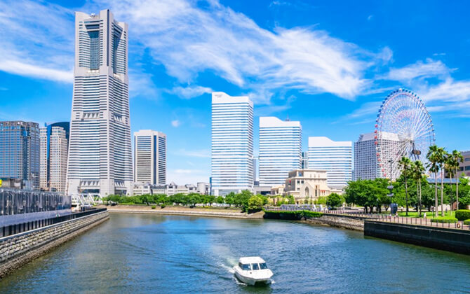
Minato Mirai 21 can be reached from Sakuragicho Station. This waterfront district is one of Yokohama’s best-known areas and was developed with tourism in mind.
HARA Model Railway Museum is a strong choice for train fans and families. Use Takashimacho Station and walk a few blocks to reach the museum.
Hongaku-ji Temple is accessible from Kanagawa Station. It is a temple with traditional Japanese architecture dating back to the 16th century.
For sightseeing by bus, Yokohama has several useful routes.
- Akai Kutsu: a retro-style red city loop bus starting at Sakuragicho Station. It visits major sightseeing spots such as Minato Mirai, Chinatown, Yamashita Park, and Harbor View Park. It operates every day and departs from Platform 4 at Sakuragicho Station.
- BAYSIDE BLUE: a bus service that began in July 2020 and connects famous sightseeing spots such as Minatomirai, the Yamashita area, Chinatown, and the Red Brick Warehouse from Yokohama Station East Exit.
- Burari Bus: operates two routes. The S route goes to Sankeien Garden and runs only on weekends and holidays, while the N route goes to Nogeyama Zoo and operates every day.
Sightseeing bus fares are simple: 220 yen, about US$1.47, for adults and 110 yen, about US$0.73, for children. The Minato Burari Ticket is also available for unlimited rides on the Municipal Subway and buses within the designated area.
Other ways to explore the city include sightseeing taxis, such as limousine-style tours with an experienced native driver, and water bus services linking Yokohama Station East Exit, Minato Mirai, and Yamashita Park.