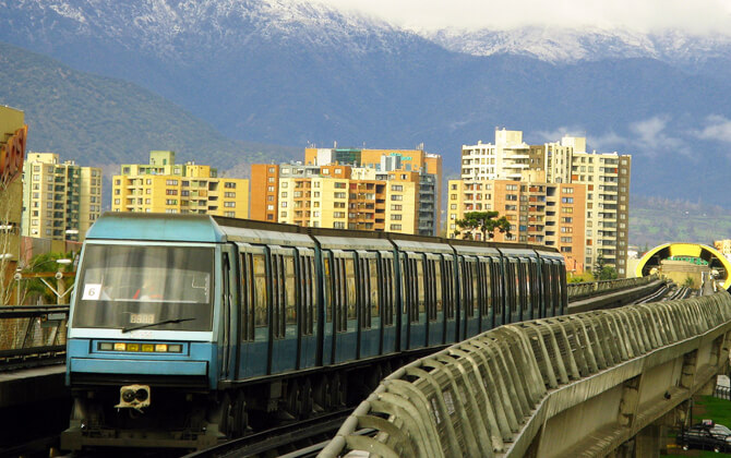
The Santiago Metro, or Metro de Santiago, is the rapid transit system serving Santiago, Chile’s capital. Operated by the state-owned Metro S.A., it has seven lines, 143 stations, and 149 kilometres (92.6 miles) of revenue route, making it the country’s first rapid transit system and one of the largest metro networks in the Americas.
| Key | Information |
|---|---|
| System | Rapid transit metro system for Santiago, Chile |
| Operator | Metro S.A. |
| Lines | Seven lines: Lines 1 to 6 and Line 4A |
| Stations | 143 stations |
| Network length | 149 kilometres (92.6 miles) |
| Daily ridership | About 2.5 million passengers per day |
| Record ridership | 2,951,962 passengers on 2 May 2019 |
| Public transport role | Key part of Santiago’s Red Movilidad city transport network |
| Major expansion | Line 7 is planned to add 26 kilometres (16.2 miles) and 19 stations, with an estimated cost of US$2.53 billion, about CLP 2.48 trillion depending on exchange rates |
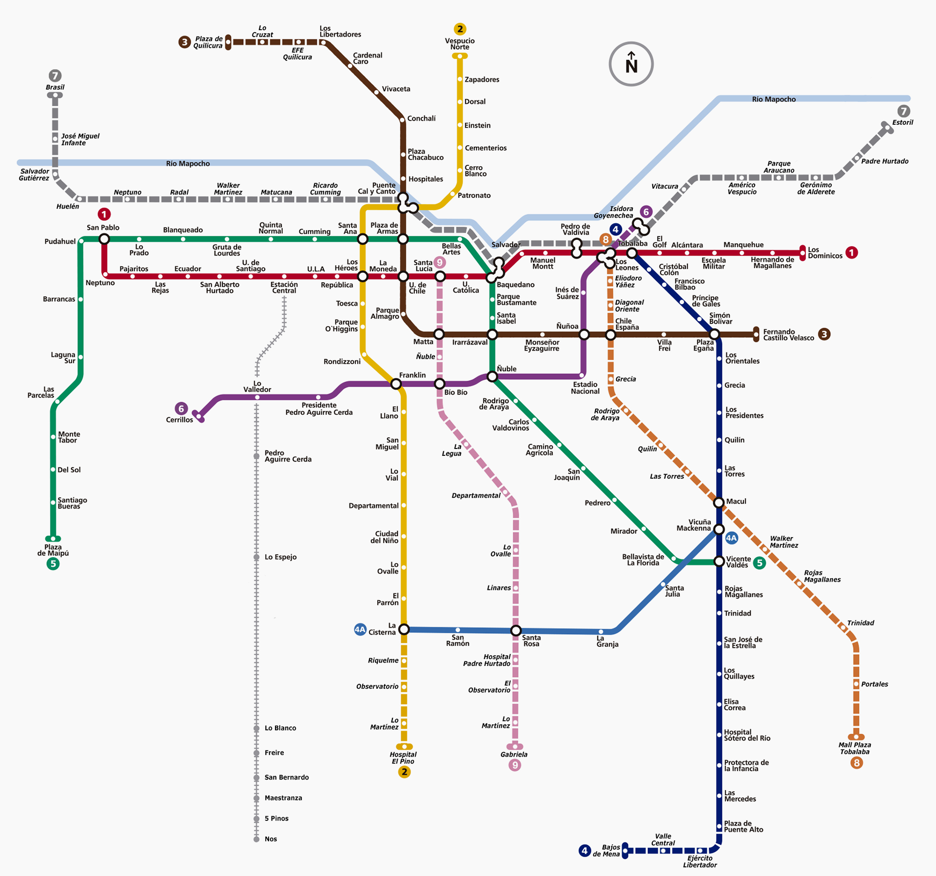
Santiago Metro Map
Map of Santiago Metro showing different lines and stations. Click on the map to enlarge it or download the Santiago Metro map in PDF format.
Santiago Metro Lines and Stations
The Santiago Metro has seven operating lines: Lines 1, 2, 3, 4, 4A, 5, and 6. Together, they form a dense route network across the city, with important transfer points for local transport, buses, and rail connections. If you are planning a trip, check the route plan, stations map, and stations list before you travel, especially when changing lines downtown.
| Station | Details |
|---|---|
| San Pablo and Los Dominicos | Termini of Line 1 |
| Vespucio Norte and Hospital El Pino | Termini of Line 2 |
| Los Libertadores and Plaza Quilicura | Termini of Line 3 |
| Tobalaba and Plaza de Puente Alto | Termini of Line 4 |
| La Cisterna and Vicuña Mackenna | Termini of Line 4A |
| Plaza de Maipú and Vicente Valdés | Termini of Line 5 |
| Cerrillos and Los Leones | Termini of Line 6 |
Major interchange stations include Los Héroes, Baquedano, Puente Cal y Canto, Tobalaba, Plaza Egaña, Ñuñoa, Franklin, and Vicuña Mackenna. These stations are especially useful when comparing a route timetable with your train schedule.
Several planned projects are linked to future expansion. Line 7 is planned to connect Renca with Vitacura, adding 19 new stations and aiming for an opening around 2027. Line 8 is planned for eastern and southeastern communes such as Providencia, Ñuñoa, Macul, La Florida, and Puente Alto. Line 9 is planned as a north-south route, with updated plans reaching Puente Cal y Canto in the north and Plaza de Puente Alto in the south. Line 4A is also expected to be modernized and extended, with a future renaming to Line 10 mentioned in the project materials.
Hours of Operation
Santiago Metro operating hours vary by day. Opening hours, opening times, working hours, and closing time can also change during special conditions, including pandemic measures or national curfews. Before you go, check the official timetable, schedule today, and timings today so you do not miss the last train.
| Service detail | Timings |
|---|---|
| Weekdays | About 5:35 am to 12:08 am |
| Saturdays | About 6:30 am to 12:08 am |
| Sundays and public holidays | About 8:00 am to 11:48 pm |
| Shorter published passenger service window noted in some information | Monday to Saturday from 6:30 to 22:30; Sundays and holidays from 8:30 to 22:30 |
| Ticket office hours | Usually aligned with metro service hours, with earlier Sunday and holiday closing times possible |
Station doors may close before the final train passes through, so allow extra time at night. The starting time, running time, train frequency, and last train can vary by line and day, so the current schedule is the safest reference.
Fares and Tickets
Santiago Metro uses time-based fares within the Red Movilidad public transport system. Regular metro fare levels are generally between 735 and 895 CLP, about US$0.75 to US$0.91 depending on exchange rates. The exact ticket price can change, so check current fare information or a fare calculator before you travel.
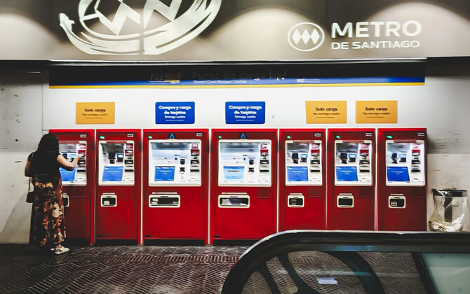
You can pay with a bip! card, a physical transit card, or a contactless bank card or digital wallet at turnstiles through the Pago Ágil system, launched on February 13, 2026. Accepted tap-to-pay options include Visa, Mastercard, Apple Pay, and Google Pay.
The bip! card is sold and reloaded at ticket offices and self-service machines. Ticket sales usually follow metro operating hours, although Sunday and holiday offices may close earlier.
Metro, buses, and Tren Nos share integrated fares under Red Movilidad. A single payment allows up to two transfers within 2 hours from the start of the trip, as long as the journey follows the transfer rules and does not repeat bus routes.
| Service detail | Timings |
|---|---|
| Peak fare band | 07:00-08:59 and 18:00-19:59 on weekdays |
| Off-peak fare band | 09:00-17:59 and 20:00-20:44 on weekdays |
| Super off-peak fare band | 06:00-06:59 and 20:45-23:00 on weekdays |
| Saturday, Sunday, and holiday fare | 815 CLP, about US$0.83 depending on exchange rates |
Special prices are available for students and seniors, including a senior metro-only fare and integrated senior and student options. A practical detail: you can board a bus with insufficient balance on your card, but you must have enough balance before entering the metro. The provided fare information covers cards and special fares; check current Red Movilidad options if you need a pass or day pass.
Connections to Other Systems
The Santiago Metro is tightly connected with transportation in Santiago through Red Metropolitana de Movilidad. This integrated transport system links metro lines, feeder and main bus routes, and selected rail services using the Tarjeta bip! smart card.
Passengers can make bus-bus or bus-metro transfers within 2 hours from the first trip, with a maximum of two changes. The same Bip! card is used to pay fares across the metro network.
| Station | Details |
|---|---|
| Los Héroes | Transfer between Line 1 and Line 2 |
| Baquedano | Transfer between Line 1 and Line 5 |
| Tobalaba | Transfer between Line 1 and Line 4 |
| Los Leones | Transfer between Line 1 and Line 6 |
| Puente Cal y Canto | Transfer between Lines 2 and 3 |
| Universidad de Chile | Transfer between Lines 1 and 3 |
| Santa Ana | Transfer between Lines 2 and 5 |
| Franklin | Transfer between Lines 2 and 6 |
| La Cisterna | Transfer between Lines 2 and 4A |
| Vicuña Mackenna | Transfer between Lines 4 and 4A |
| Plaza Egaña | Transfer between Lines 3 and 4 |
| Ñuñoa | Transfer between Lines 3 and 6 |
| Lo Valledor | Line 6 connection with MetroTren Nos |
| Pajaritos | Important interchange point for intercity buses |
Future links are expected to add more transfer options involving Lines 7, 8, and 9, along with a possible future airport connection from Line 7. The available network information focuses on metro, bus, and rail services rather than trams or a tramway connection.
Airport Connections
Santiago Airport, or SCL, is connected with central Santiago by bus, metro combination, taxi, car, and shuttle. The best option depends on your budget, time, luggage, and preferred route.
- Bus: Centropuerto runs direct services from Estación de Buses Aeropuerto Internacional Arturo Merino Benítez to Terminal Los Héroes every 20 minutes. The journey takes about 40 minutes and costs about US$3, roughly CLP 2,940 depending on exchange rates.
- Bus and subway: One route combines an airport bus with the metro from Barrancas to Plaza de Armas. The trip takes about 47 minutes.
- Taxi: A taxi from Santiago Airport to Santiago takes about 18 minutes and costs US$27-33, roughly CLP 26,460-32,340 depending on exchange rates.
- Drive: The road distance is 20.3 kilometres (12.6 miles), with a driving time of about 18 minutes.
- Shuttle: Private shuttle buses take about 19 minutes and cost US$36-38, roughly CLP 35,280-37,240 depending on exchange rates.
Based on the listed route information, the bus is the cheapest option, while the taxi is the fastest. Direct airport buses run daily, with a frequency of every 20 minutes.
Chile has also confirmed plans for a future metro link to Santiago Airport. The proposed Line 7A would branch from the future Huelén station on Line 7 and is expected to provide an underground airport connection in about 7 minutes once completed.
Facilities and Services
Santiago Metro stations offer useful services for daily travel. Ticket offices, public telephones, and network information panels are available in every station, while automatic recharge machines help passengers top up the bip! card with cash or a Redbanc-enabled card. In busier stations, MetroTV screens show system updates, music videos, and short news segments.
Several stations support multimodal trips. The Bicimetro network offers bicycle parking at selected stations with daily, weekly, and monthly options. Station parking and park-and-ride facilities are also available at some stations; if you plan to drive, check parking charges and parking charges per day before arriving.
Many underground stations include shops and convenience stores. Large transfer stations such as Baquedano have food vendors and retailers, while Universidad de Chile includes a small underground shopping area.
Selected stations also offer free Wi-Fi and public libraries. Some stations display artworks connected to the areas they serve, adding a cultural touch to the ride. Staff and security teams help keep the system safe, especially during busy periods.
Safety measures are easy to spot. Platforms have a painted yellow line that passengers should not cross except when boarding, and warning signage is widely used. During rush hour, Metro staff help manage crowds and assist disabled passengers.
Regulations
Santiago Metro uses the integrated Red Metropolitana de Movilidad fare system. Passengers travel with a contactless smart card called Tarjeta bip!, and single-trip metro-only tickets are no longer sold.
Bus-bus and bus-metro transfers are allowed within 2 hours from the first trip, with a maximum of two changes. Transfer rules apply, so check your route before relying on an integrated fare.
Platform safety rules are clearly posted. Passengers should stay behind the yellow line until boarding. During rush hour, staff may stand near the platform edge to reduce crowding and help disabled passengers.
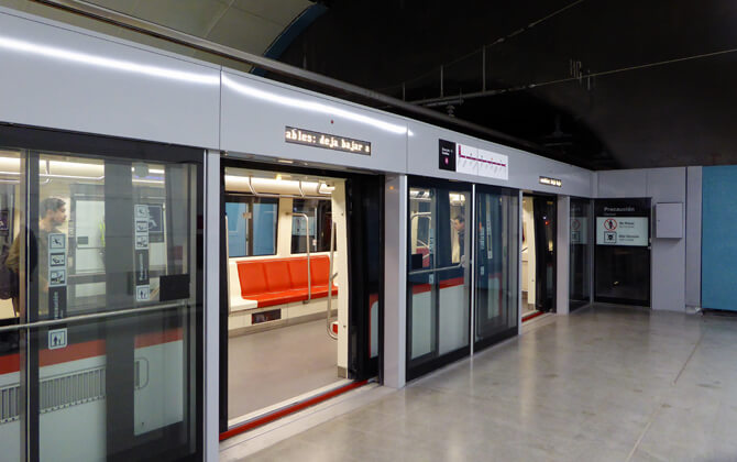
Most lines do not have a physical barrier between platforms and tracks, including the electrified third rail. Lines 3 and 6 are exceptions: they use platform-edge doors and overhead line equipment instead of conductor rails.
A regulation announced in 2025 prohibits supermarket carts and cargo yaguas from entering the network. The measure was introduced to reduce illegal trade and protect metro infrastructure, with inspections at station entrances.
Services can change during special situations, and stations may close earlier than the listed network closing time. Check the timetable before traveling, particularly late in the evening.
Tips
The Santiago Metro is straightforward to use, but a few local habits make the trip smoother.
The system is generally safe, especially on busy routes such as Line 1, but opportunistic theft can happen in crowded stations and trains. Keep your belongings close, and wear your backpack in front when the carriage is packed.
Weekday rush hour is usually around 7:00-9:00 in the morning and 17:00-20:00 in the evening. Trains can become very crowded. On Line 1, the direction toward Los Dominicos is busier in the morning, while the direction toward San Pablo is busier in the evening.
Metro etiquette is simple: let passengers exit first, do not block the doors, and keep large bags low and close to you. Priority seats are for elderly, disabled, pregnant, or less mobile passengers, so offer them when needed.
- Tap in at the station entrance; you do not need to tap out at your destination.
- If you combine metro and bus trips, bip! remains the most reliable option for transfers.
- Remember that the integrated system allows up to two transfers within 2 hours.
- Look for Salida signs when you need the exit.
- Check the line direction carefully before boarding, especially at interchange stations.
History
The idea of an underground railway in Santiago dates back to 1944, when planners began looking for ways to improve the city’s transport system as population growth put pressure on roads and buses. More detailed planning followed in the 1960s, when Juan Parrochia became Chief Architect of the Intercommunal Plan of Santiago and helped develop a master plan that included a metro network.
In 1968, the government approved an international proposal from the Franco-Chilean consortium BCEOM SOFRETU CADE. It called for five lines and about 60 kilometres (37.3 miles) of network by 1990. Construction of the first line began on 29 May 1969, linking the Civil District with Barrancas, now Lo Prado.
The first section of Line 1 opened on 15 September 1975. It initially ran mostly underground from San Pablo to La Moneda beneath Alameda, then extended to Providencia in 1977 and reached Escuela Militar in Las Condes by 1980. Line 2 opened in March 1978 between Los Héroes and Franklin, later extending south to Lo Ovalle.
The original expansion plans were slowed by the 1982 economic crisis and the earthquake of 3 March 1985. Some resources shifted to reconstruction, and progress was limited to works such as new Line 2 stations in the mid-1980s. In 1989, Metro de Santiago was reorganized as the state-owned company Metro S.A.
Expansion returned in the 1990s. Line 5 opened on 5 April 1997, first connecting Baquedano with Bellavista de la Florida. In March 2000, a central section of Line 5 opened through the historic downtown, linking Baquedano and Santa Ana via Plaza de Armas and Bellas Artes. That made it possible to connect all three existing lines at the time.
From 2000 onward, the metro grew quickly. Line 5 reached Quinta Normal in 2004, Line 2 expanded north and south between 2004 and 2005, Line 4 opened in November 2005, and Line 4A followed in August 2006. Line 1 extended east to Los Dominicos in 2010, while Line 5 expanded west to Maipú between 2010 and 2011.
In 2012, Santiago Metro was named the best metro system in America. Line 3 opened on 22 January 2019 after long delays, becoming the newest line at that time.
In October 2019, the network was heavily affected by social protests triggered by a fare increase across the Metropolitan Mobility Network, causing repeated service interruptions at several stations.
More growth was announced in 2017 with Line 7, planned to connect Renca with Vitacura and open around 2027. The broader expansion program also includes further lines and extensions, keeping the metro at the center of Santiago’s transport system.
Future Extensions
The Santiago Metro is expanding through confirmed projects, approved extensions, and longer-term proposals. The main plans focus on Line 7, the west extension of Line 6, and future Lines 8 and 9, all aimed at improving coverage in areas that still depend heavily on buses and road traffic.
Line 7 is the flagship expansion project. It is planned to run for 26 kilometres (16.2 miles) with 19 stations, connecting Renca in the northwest with Vitacura in the northeast. The route is designed to relieve pressure on Line 1 and serve municipalities including Cerro Navia, Quinta Normal, Santiago, Providencia, and Las Condes. Opening is expected in 2027 or 2028, depending on the project stage referenced.
The Line 7 project also includes modern Alstom rolling stock, with autonomous Metropolis trains planned for the route. These trains are intended to improve capacity and passenger experience on a major cross-town corridor.
Line 6 is planned to extend west toward Maipú, near Hospital El Carmen. One version describes a 6.4-kilometre (4-mile) extension with three new stations, while other summaries describe a shorter project of around 3 kilometres (1.9 miles) with one new station and an opening target of 2027. In both cases, the goal is better service for the western metropolitan area.
Line 8 is proposed as a north-south corridor through Providencia, Ñuñoa, Macul, La Florida, and Puente Alto. It is described as having 14 stations and about 19 kilometres (11.8 miles) of new track, with major time savings expected for passengers in southeastern Santiago.
Line 9 is planned for southern and central Santiago, with reports describing a 27-kilometre (16.8-mile) route and 19 stops along Santa Rosa Avenue. It is expected to connect communes such as Recoleta, Santiago, San Miguel, San Joaquín, La Granja, San Ramón, La Pintana, and Puente Alto. Updated plans also mention extensions toward Puente Cal y Canto and Plaza de Puente Alto.
Other long-term ideas include possible Line 7 extensions toward La Dehesa, a project referred to as Line A for an airport connection, and broader modernization work across the existing system. Proposed upgrades include platform doors on Line 1 and station improvements to support a larger, more interconnected metro network.
Nearby Attractions

Metro de Santiago is a convenient starting point for exploring central Santiago. From metro stations in the core area, visitors can reach cultural sites, historic landmarks, parks, and popular neighborhoods without relying only on road transport.
- Cerro Santa Lucía is one of the closest highlights and is listed within a short walk of the metro area.
- Biblioteca Nacional, Teatro Municipal de Santiago, and Plaza de Armas are central city attractions associated with the station area.
- Barrio Lastarria and Barrio Paris Londres offer dining, walkable streets, and local character.
- Iglesia San Francisco and the Museo de Arte Colonial de San Francisco are nearby options for heritage and religious architecture.
- Castillo Hidalgo and the Monument to General Bernardo O’Higgins Riquelme are additional points of interest close to the station.
If you are planning a day out, the metro makes it easy to combine sightseeing with nearby cafés, shops, and guided experiences in central Santiago.