The City Circle is Sydney’s central railway loop through the CBD and Haymarket, forming the core of the Sydney Trains system. Despite the name, it is not a full circle but a horseshoe-shaped route linking Central, Town Hall, Wynyard, Circular Quay, St James, and Museum before returning to Central. Most of the route runs underground, while Central and Circular Quay are above ground. It is a key part of public transport and city transport in Sydney, carrying suburban rail services through the city centre and connecting with the wider network.
| Key | Information |
|---|---|
| System | Sydney Trains under Transport for NSW |
| Route shape | Horseshoe-shaped loop, not a true circle |
| Main stations | Central, Town Hall, Wynyard, Circular Quay, St James, Museum |
| Track layout | Double track throughout; effectively four tracks at Central because the route has two ends there |
| Opening dates | Museum and St James opened in 1926; Town Hall and Wynyard in 1932; Circular Quay completed the loop in 1956 |
| Accessibility | All City Circle stations have step-free access to platform level |
| Typical operating hours | About 4:00am to 1:00am |
| Typical frequency | About every 6 to 8 minutes, or every 3 to 5 minutes in peak periods |
City Circle (Sydney) Map
Map of City Circle (Sydney) showing different lines and stations. Click on the map to enlarge it or download the City Circle (Sydney) map in PDF format.

Network Structure: Lines, Stations
The City Circle is a mostly underground rail route in central Sydney. It sits at the heart of transportation in Sydney and supports several Sydney Trains services moving through the CBD. The route plan is horseshoe-shaped, with trains running in a U-shaped pattern rather than a perfect loop.
The line is double track throughout. At Central, it effectively works like four tracks because both ends of the route meet at the same station. Central and Circular Quay are above ground, while Town Hall, Wynyard, St James, and Museum are underground. All stations have step-free access to platform level.
Service patterns change depending on the train schedule. The City Circle is commonly used by Inner West & Leppington Line and Airport & South Line services, while Liverpool & Inner West Line trains also run via the City Circle Inner. Western and Northern line trains usually bypass the loop and continue across the Harbour Bridge to the North Shore line.
The route was built in stages. Museum and St James opened in 1926, Town Hall and Wynyard followed in 1932, and Circular Quay completed the loop in 1956.
Stations
| Station | Details |
|---|---|
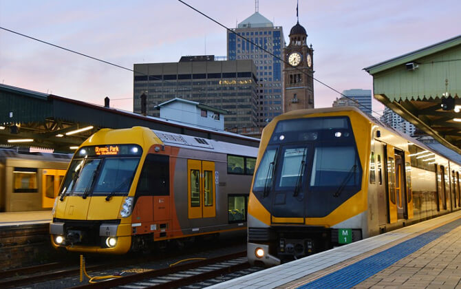
| Central | Code: CEN. Opened 28 February 1855. Above ground. |
| Town Hall | Code: THL. Opened 28 February 1932. Underground. |
| Wynyard | Code: WYD. Opened 28 February 1932. Underground. |
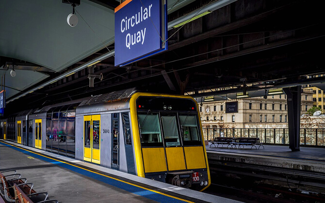
| Circular Quay | Code: CQY. Opened 22 January 1956. Above ground. |
| St James | Code: SAJ. Opened 20 December 1926. Underground. |
| Museum | Code: MSM. Opened 20 December 1926. Underground. |
This stations list is the full operating set of the City Circle, with the route returning to Central after Museum.
Operating Schedule and Frequency
The City Circle timetable generally starts at 4:00am and runs until 1:00am, so it does not operate 24/7. If you are checking opening hours, working hours, or timings today, it is best to confirm the latest schedule today through Sydney Trains timetable information.
| Service detail | Timings |
|---|---|
| Starting time | Generally 4:00am |
| Closing time | Generally 1:00am |
| Last train | Services usually finish around 1:00am |
| Frequency | Usually every 6 to 8 minutes |
| Peak frequency | About every 3 to 5 minutes |
| Operating pattern | Not a 24/7 service |
For practical trip planning, those are the usual operating hours, opening times, and service timings. Actual running time and route timetable details depend on the train service using the loop.
Fare Structure
Sydney Trains fares are based on distance travelled. Since 2014, the main ticket system has been the reloadable Opal card, though single trip tickets are also available from station ticket dispensers for passengers without an Opal card or contactless payment.
If you are comparing fare, price, ticket price, or total cost, the amount depends on distance and the type of ticket or pass you use. Reduced fares apply to eligible passengers using Child/Youth, Concession, or Gold Senior/Pensioner Opal cards. Distances below are shown in kilometres and miles.
| Fare Type | 0-10 km / 0-6.2 miles | 10-20 km / 6.2-12.4 miles | 20-35 km / 12.4-21.7 miles | 35-65 km / 21.7-40.4 miles |
| Adult Opal Card | 3.46 AUD ($2.28) | 4.30 AUD ($2.84) | 4.94 AUD ($3.26) | 6.61 AUD ($4.36) |
| Child/Youth Opal Card | 1.73 AUD ($1.14) | 2.15 AUD ($1.42) | 2.47 AUD ($1.63) | 3.30 AUD ($2.18) |
| Gold Senior/Pensioner Opal Card | 1.73 AUD ($1.14) | 2.15 AUD ($1.42) | 2.47 AUD ($1.63) | 2.50 AUD ($1.65) |
| Concession Opal Card | 1.73 AUD ($1.14) | 2.15 AUD ($1.42) | 2.47 AUD ($1.63) | 3.30 AUD ($2.18) |
Opal single trip ticket prices are also distance-based.
| Distance | Adult | Child/Youth |
| 0-10 km / 0-6.2 miles | 4.20 AUD ($2.77) | 2.10 AUD ($1.39) |
| 10-20 km / 6.2-12.4 miles | 5.20 AUD ($3.43) | 2.60 AUD ($1.72) |
| 20-35 km / 12.4-21.7 miles | 6.00 AUD ($3.96) | 3.00 AUD ($1.98) |
| 35-65 km / 21.7-40.4 miles | 8.00 AUD ($5.28) | 4.00 AUD ($2.64) |
Opal also includes transfer discounts and off-peak savings. Adult fares get a 2 AUD ($1.32) transfer discount, while Child and Concession fares receive a 1 AUD ($0.66) discount when transferring between modes as part of one journey. Off-peak travel is discounted by 30%.
Daily and weekly caps help limit spending across the network, which is useful if you travel often or use a day pass-style approach to public transport spending.
| Passenger Group | Daily Cap | Weekly Cap |
| Adults | 19.30 AUD ($12.74) Monday to Thursday; 9.65 AUD ($6.37) Friday, Saturday, Sunday, and public holidays | 50 AUD ($33.00) |
| Children and Concession | 9.65 AUD ($6.37) Monday to Thursday; 4.80 AUD ($3.17) Friday, Saturday, Sunday, and public holidays | 25 AUD ($16.50) |
| Seniors and Pensioners | 2.50 AUD ($1.65) | 17.50 AUD ($11.55) |
For airport travel, the airport stations include a gate fee. In 2026, the airport train fare to the city centre is 22.25 AUD ($14.69) in peak times and 20.95 AUD ($13.83) off-peak, including a gate fee of 17.92 AUD ($11.83). If you need a fare calculator, Sydney’s official ticket tools are the place to check exact trip pricing.
Interconnections
The City Circle is one of the main interchange links in Sydney’s rail system. It ties together several heavy rail services and also connects with light rail at Central, making it a key part of local transport and wider city transport.
- Central — connects to T1, T2, T3, T4, and T8, and also links with light rail.
- Town Hall — connects to T1, T2, T3, T4, and T8.
- Wynyard — connects to T1, T2, T3, and T8.
- Circular Quay — connects to T2, T3, and T8.
- St James — connects to T2 and T8.
- Museum — connects to T2 and T8.
These interchanges let trains enter and leave the City Circle from different parts of the network. Services often change line identity at Central. The loop also links with the North Shore corridor through the Harbour Bridge, although Western and Northern line services usually continue over the bridge rather than using the City Circle.
In everyday operation, Inner West & Leppington Line services commonly use the City Circle Outer, while Airport & South Line services generally use the City Circle Inner. Liverpool & Inner West Line trains also operate via the City Circle Inner, and flying junctions at Central allow these patterns to be adjusted as needed.
Airport Connectivity
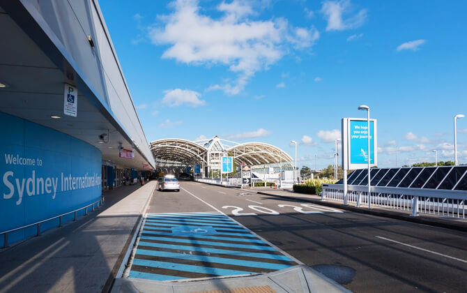
Sydney Kingsford Smith Airport connects directly to the city by the T8 Airport & South Line. There is one station for international flights and one for domestic flights: International Airport Station and Domestic Airport Station.
From the City Circle, the main airport connection is via Central. T8 services also link the airport with stations around the loop, including Museum, St James, Circular Quay, Wynyard, and Town Hall. For many travelers, this path train option is the most practical way to move between the airport and central Sydney.
Station facilities are on the ground floor at the airport stations. Other transport options include car hire, taxi, bus, and limousine services. The train is often the most efficient transport choice for reaching the city centre.
Rules and Guidelines
The City Circle route knowledge diagrams are issued for route knowledge only. They are uncontrolled documents, and any safety-related use must be checked against a controlled source or verified in the field.
Drivers must change ends and drive from the leading driving compartment in the direction of travel. Before changing ends, marker lights must be set to red and, where possible, the trip should be latched up. After changing ends, tail lights must show white marker lights in the direction of travel before the train moves.
All train movements within the Sydney Underground area are controlled by the Signaller at Sydney Signal Box, working with the Train Controller. If an unsignalled movement is required, the driver must not exceed 10 km/h or 6.2 mph and may proceed only when authorised by the Signaller.
Turnback working at Central is permitted for certain down City Outer and down Shore trains, provided no part of the train has passed the relevant car marker. Similar working applies to down City Inner trains via the No. 621 crossover under the same condition.
When a train approaches certain signals showing a low speed or medium caution indication, it must be drawn past the T marker sign. Otherwise, timing will not commence and the train stop will not clear.
For passengers, these are the general Sydney Trains rules and guidelines to help keep the system safe:
- Animals are prohibited, except service and law enforcement dogs.
- Open alcoholic drinks and drinking alcohol on trains or at stations are prohibited.
- Intoxicated, violent, or otherwise unacceptable behaviour may lead to removal from Sydney Trains premises.
- Hazardous substances, flammable materials, and potentially dangerous items are prohibited.
- Supermarket trolleys are not permitted on train premises.
- Smoking, including e-cigarettes, is prohibited on all train premises.
- Bicycles are allowed on trains, but must not obstruct passenger movement.
- Areas for passengers with reduced mobility must not be occupied by other groups.
- Passengers should keep left on escalators so others can pass on the right.
- Feet must not be placed on seats.
- Passengers should not board or exit after the door closing announcement.
- Seats reserved for elderly, disabled, or pregnant passengers should not be used by others.
History
The idea for the City Circle formed part of a 1915 report prepared for the New South Wales government by chief railway engineer John Bradfield after overseas study. His plan was influenced in large part by the New York City Subway.
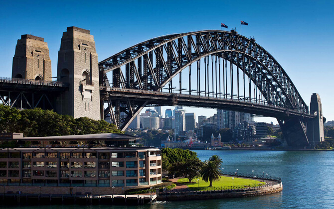
Construction began the following year and the line opened in stages. Museum and St James were the first stations to open in 1926 during the initial electrification of Sydney railways. Town Hall and Wynyard followed in 1932, alongside the opening of the Sydney Harbour Bridge.
That western section included four tunnels. Two connected to the Harbour Bridge, while the two City Circle tunnels ended at Wynyard. In 1956, the dead ends at St James and Wynyard were joined, and Circular Quay opened to complete the loop.
Central and Circular Quay are above ground, with Circular Quay elevated beneath the Cahill Expressway. The other stations are underground. Several unused tunnels also remain, including former tramway tunnels at Wynyard and stub tunnels at St James.
The route is double track throughout, though it effectively becomes four tracks at Central because there are two ends of the same track. The City Outer is used by clockwise trains, and the City Inner is used by anti-clockwise trains.
Before the Eastern Suburbs line was integrated into the Illawarra Line in 1980, Illawarra services also ran around the City Circle. Western and Northern line trains usually do not use the loop and instead cross the Harbour Bridge to the North Shore line.
After resignalling in the 1990s, the operating pattern changed for safety reasons. Signals on the City Circle can no longer show a calling-on aspect and instead use low-speed indications, which means a train cannot enter a platform while the previous train is departing. Because of that, the system cannot handle more than 20 trains per hour.
| Station | Details |
|---|---|
| Central | Code: CEN. Opened 28 February 1855. |
| Town Hall | Code: THL. Opened 28 February 1932. |
| Wynyard | Code: WYD. Opened 28 February 1932. |
| Circular Quay | Code: CQY. Opened 22 January 1956. |
| St James | Code: SAJ. Opened 20 December 1926. |
| Museum | Code: MSM. Opened 20 December 1926. |
Future Developments
Future developments linked to the City Circle focus mainly on Circular Quay. Planning work aims to improve the precinct as both a transport hub and a public destination, with better connections between the city and the harbour, more useful public space, and a clearer identity for the area.
One long-term idea is to bring together the fragmented public realm around Circular Quay into a more coherent square. This would improve pedestrian movement, reduce clutter, strengthen harbour views, and create a more welcoming waterfront setting. The possible removal or redesign of the Cahill Expressway and the railway embankment has been identified as a major opportunity.
Planned and proposed changes include upgrades to the station, ferry wharves, and surrounding public areas. The broader Circular Quay Renewal process is being led by Transport for NSW with state planning agencies, and further design work, planning approvals, environmental assessment, and community consultation are still required.
Future proposals also refer to a new planning framework for the precinct, intended to guide development applications once finalised. Before that, draft plans are expected to go on public exhibition so feedback can shape the next stage.
Related public domain plans for Alfred Street, Customs House Square, Loftus Street, Reiby Place, Young Street, and Phillip Street point to a more connected and pedestrian-friendly area, with consistent paving, more trees, better outdoor dining, shared zones, and stronger links back to Circular Quay.
Tourist Attractions
The City Circle is more than a commuter route. For visitors, it doubles as a compact way to explore central Sydney by train, with several stations offering architecture, history, and memorable views. It is an easy sightseeing route if you want to move around the city using public transport rather than buses, trams, or walking the whole distance.
Central
Central Station stands out for its grand European-style hall and historic atmosphere. It is also the departure point for regional and interstate trains, and visitors can spot historic photos showing trams that once ran right up to the front entrance.
Circular Quay
Circular Quay is one of the most scenic railway stations anywhere. From the platform, you get direct views framed by the Sydney Harbour Bridge and the Opera House without even stepping outside. It is a great stop for a quick photo.
St James
St James has the feel of a small gallery, with historical photographs, occasional modern art, and many original fixtures still in place. Wrought iron fencing and brass details add to the station’s period character.
Museum
Museum Station, named for the nearby Australian Museum, feels like stepping into another era. Benches, signs, clocks, tiled walls, and even advertising are styled to preserve the historic look.
Town Hall and Wynyard
Town Hall and Wynyard are more functional stations, but they still have appeal for visitors. The underground walk between Town Hall Station and Pitt Street Mall, running beneath QVB and Myer, is something quite unusual in Australia.
If you want quieter conditions for photos or a relaxed stop-by-stop ride, off-peak travel is the best option. Trains run regularly in both directions, all City Circle stations are wheelchair accessible, and families with prams should watch for occasional gaps between train and platform.
Because the City Circle is really a horseshoe, not a full circle, it helps to check the route and direction before boarding. Even so, it is very easy to hop on and off and turn a simple train ride into a short self-guided tour of central Sydney.