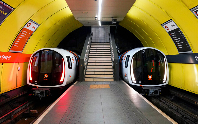
The Glasgow Subway is an underground light metro system in Glasgow, Scotland. It opened on 14 December 1896 and is the third-oldest underground metro system in the world, after London and Budapest. This compact public transport system has a single circular route with 15 stations, trains running clockwise and anticlockwise in separate tunnels, and a distinctive narrow 4 ft (1,219 mm) track gauge. The full loop is about 10.5 kilometres (6.5 miles), and while the running line is entirely underground, the network connects well with wider city transport and local transport in Glasgow.
| Key | Information |
|---|---|
| System | Glasgow Subway |
| Type | Underground light metro |
| Opening date | 14 December 1896 |
| Route | Single circular double-track loop |
| Length | 10.5 kilometres (6.5 miles) |
| Stations | 15 |
| Directions | Outer Circle clockwise, Inner Circle anticlockwise |
| Operator | Strathclyde Partnership for Transport (SPT) |
| Track gauge | 4 ft (1,219 mm) |
| Opening hours | Monday to Saturday 06:30 to 23:40; Sunday 10:00 to 18:12 |
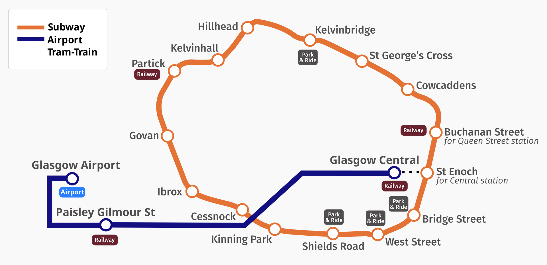
Glasgow Subway Map
Map of Glasgow Subway showing next and stations. Click on the map to enlarge it or download the Glasgow Subway map in PDF format.
Lines and Stations
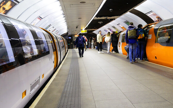
The Glasgow Subway has one circular line with 15 active stations. Trains run on two tracks in opposite directions: the Outer Circle runs clockwise and the Inner Circle runs anticlockwise. All trains stop at every station, so the route plan is simple and easy to follow.
The system forms a loop of about 10.5 kilometres (6.5 miles) beneath both sides of the River Clyde. The line is fully underground, although the maintenance depot at Broomloan Road, between Govan and Ibrox, is above ground.
The stations map covers the city centre and the West End. Here is the full stations list:
| Station | Details |
|---|---|
| Govan | Station on the circular subway route. |
| Partick | Key interchange with the North Clyde and Argyle lines. |
| Kelvinhall | West End station with access to the Kelvingrove area. |
| Hillhead | Station with a mixed platform layout. |
| Kelvinbridge | West End station with park and ride. |
| St George’s Cross | Station on the north side of the loop. |
| Cowcaddens | City access station. |
| Buchanan Street | Key interchange linked to Queen Street station by moving walkway. |
| St Enoch | Central station with useful links to nearby rail stations. |
| Bridge Street | Station with park and ride. |
| West Street | Station on the south side of the route. |
| Shields Road | Station with park and ride. |
| Kinning Park | Station on the circular route. |
| Cessnock | Station serving the southwest part of the loop. |
| Ibrox | Station near the depot area and stadium district. |
The subway is known for compact stations and varied layouts, including island platforms and opposing side platforms. Hillhead is a good example, using one side platform and one island platform.
Partick, Buchanan Street, and St Enoch are especially useful if you are planning connections with other public transport. Several stations also have station parking through park and ride sites, including Kelvinbridge, Bridge Street, and Shields Road.
Schedule and Timetables
The Glasgow Subway timetable can vary, so for schedule today or timings today, it is best to check SPT before you travel. In general, trains run every 6 to 8 minutes on both the Inner Circle and Outer Circle. That frequency usually applies during off-peak periods as well.
The usual operating hours are 06:30 to 23:40 from Monday to Saturday and 10:00 to 18:12 on Sundays. If you need the first departure, last train, or closing time, use the route timetable below.
Outer Circle
| Service detail | Timings |
|---|---|
| Starting time from Govan | Monday to Saturday 06:30; Sunday 10:00 |
| Starting time from St Enoch | Monday to Saturday 06:32; Sunday 10:03 |
| Last train from Govan | Monday to Saturday 23:16; Sunday 17:50 |
| Last train from St Enoch | Monday to Saturday 23:30; Sunday 18:00 |
Inner Circle
| Service detail | Timings |
|---|---|
| Starting time from Govan | Monday to Saturday 06:30; Sunday 10:00 |
| Starting time from St Enoch | Monday to Saturday 06:32; Sunday 10:00 |
| Last train from Govan | Monday to Saturday 23:16; Sunday 17:50 |
| Last train from St Enoch | Monday to Saturday 23:28; Sunday 18:00 |
For most trips, the running time is short because the system is compact. If you are wondering when the subway will close, the normal closing time is 23:40 on Monday to Saturday and 18:12 on Sunday.
Tariffs, Tickets and Travel Cards
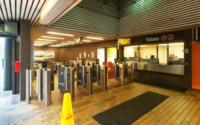
All stations have ticket machines and staffed kiosks, so buying a ticket is straightforward. The fare options include single, return, and all-day tickets for adults and children. If you are travelling more than two stops, a day pass is often the better-value choice.
For longer stays, there is also a Smartcard. This contactless card can be topped up with credit and used for travel around the city, making it a practical option for regular transport use.
| Type | Adult | Child |
|---|---|---|
| Single | £1.80 (about $2.27) | £0.85 (about $1.07) |
| Return | £3.40 (about $4.28) | £1.60 (about $2.01) |
| All Day (unlimited travel) | £4.30 (about $5.41) | £2.15 (about $2.71) |
All-day travel and Smartcard savings
For all-day travel, Pay As You Go credit on a Smartcard is the best-value pass option mentioned here. It gives unlimited travel every day of the week and can cost less than a paper all-day ticket.
Combined day tickets
SPT also offers combined ticket options covering Subway, rail, and bus travel. These include the Roundabout ticket for Subway and rail, along with other integrated city transport products for wider journeys across Glasgow.
Some combined tickets are tied to sightseeing options too, including discounts when Subway travel is paired with a hop-on hop-off City Sightseeing bus tour.
ZoneCard
The ZoneCard is another travel card for unlimited rail, bus, and Subway travel across selected zones. It suits passengers planning broader transportation in Glasgow over multiple days.
Connections with other systems
The Glasgow Subway links with the wider transport network across the city, though these connections were only formally developed during the 1970s modernisation. Today, it works as part of Glasgow’s public transport system rather than as a standalone route.
- Partick connects with the North Clyde and Argyle lines of the suburban railway network.
- Buchanan Street is linked by a moving walkway to Queen Street main-line station.
- St Enoch is a short walk from Glasgow Central and Argyle Street railway stations.
- Most subway stations also connect with bus routes.
Partick is the most important interchange, combining subway, rail, and nearby bus connections in one place. Buchanan Street is another major transport hub, while St Enoch gives easy access to central rail services.
The subway does not connect directly to Glasgow International Airport, but bus links provide a practical alternative.
Connections to the airport
Glasgow Subway does not go directly to Glasgow Airport, but it can still form part of an airport route when combined with rail and bus links.
From Glasgow Central or Glasgow Queen Street, you can take the AirportExpress 500 bus to Glasgow Airport. Only tickets marked to, from, or via “Glasgow Air XBus” are valid on that service.
If you are travelling from Ayrshire or Inverclyde, take the train to Paisley Gilmour Street and connect to the frequent 757 bus to the airport. This bus still runs, but through rail-and-bus tickets are not available.
From north-west Glasgow, Milngavie, Dumbarton, Helensburgh, and the West Highlands, passengers can change at Partick for a frequent bus connection to the airport.
Airlink tickets to Glasgow Airport combine rail and bus travel and can be bought at a staffed station or by phone on 0344 811 0141.
Glasgow Prestwick Airport has its own rail station, Prestwick International Airport Station, on the Glasgow Central to Ayr route. The station is linked to the terminal by a covered walkway, and the journey from Glasgow Central takes about 45 minutes.
For Edinburgh Airport, you can change at Haymarket, Edinburgh Park, or Edinburgh Gateway for Edinburgh Trams. Combined Airlink tickets are also available for onward bus or tramway travel.
Park and Ride
There are three park and ride sites on the Glasgow Subway network: Shields Road, Bridge Street, and Kelvinbridge. They offer a simple way to leave the car and continue by subway into the city centre.
| Station | Details |
|---|---|
| Shields Road | Subway-based station parking, GPS G5 8PL, 800 spaces, disabled parking, CCTV, shop and snacks, cycle storage, and realtime information. |
| Bridge Street | Subway-based station parking, GPS G5 9NR, 159 spaces, CCTV. |
| Kelvinbridge | Subway-based station parking, GPS G4 9HG, 150 spaces, disabled parking, CCTV. |
Shields Road is the largest site and has a subway journey of about five minutes into the city centre. Bridge Street is at 67 Eglinton Street, Glasgow, and Kelvinbridge car park is at 99 South Woodside Road, Glasgow.
The source material also mentions two bus-based park and ride sites in Scotland that are not part of the Glasgow Subway system:
| Station | Details |
|---|---|
| Halbeath | Bus-based, GPS KY11 7EG, 1,021 spaces, disabled parking, cycle lockers, electric charging points, CCTV, staffed terminal building, toilets, vending machines, and travel information. |
| Kincardine | Bus-based, GPS FK10 4NT, 67 spaces, no disabled access, park free and pay on the bus. |
No parking charges or parking charges per day are listed here for the Glasgow Subway park and ride sites. Shields Road has also been used for a special event offer that included free Subway travel with parking, subject to proof of event participation.
Tips and Advice
The Glasgow Subway is easy to use, but a few practical habits can make the trip smoother, especially at busy times.
- Stand near the platform marks if you want to board quickly. Trains tend to stop in roughly the same place each time.
- Buy your pass the night before if you commute regularly. Morning queues at ticket machines and desks can be longer.
- If you need to stand, move further down the carriage. It helps other passengers and may improve your chances of getting a seat later.
- Think about your exit before the train arrives. Picking the right carriage can save time when you reach the stairs.
- On quieter days, the middle carriage may have more room. When it is busy, the door farthest from the stairs can be a better bet.
- If your trip allows it and the detour is only one or two stops, avoiding Govan Halt can sometimes reduce extra waiting linked to driver changes.
- Keep your ticket, card, or pass ready at the barriers.
- If something goes wrong at the gate, step aside first and sort it out there rather than blocking the line.
These small things make the system easier to navigate and help keep journeys moving.
History
The Glasgow Subway opened on 14 December 1896, making it the third-oldest underground metro system in the world after London’s Metropolitan Railway and the Budapest Metro. It began as the Glasgow District Subway, was later renamed the Glasgow Subway Railway, then the Glasgow Underground in 1936, and officially returned to the name Subway in 2003.
The system was built as a cable railway and opened as a circular loop of about 10.5 kilometres (6.5 miles), with tracks running north and south of the River Clyde. Its unusual 4 ft (1,219 mm) gauge and very small tunnel diameter shaped the compact trains used ever since.
1890–1977
The Glasgow District Subway Company was incorporated by the Glasgow District Subway Act 1890, and construction started in 1891. The line opened on 14 December 1896 with cable haulage powered by a steam plant between West Street and Shields Road. There was no cable link to the depot, so trains had to be transferred by crane at the Govan workshops, and the two tracks were completely separate with no points.
The original wooden carriages were built by the Oldbury Railway Carriage and Wagon Company, with more cars supplied in 1897. From 1898, trailer carriages were added by Hurst Nelson & Company. Some of these vehicles remained in service, in upgraded form, until 1977. In 1935, the line was electrified using a third rail at 600 volts direct current, and the last cable-hauled service ran on 30 November 1935.
Glasgow Corporation took over the company in 1923. During World War II, use increased, but the stations were not effective air-raid shelters because they were relatively shallow. On 18 September 1940, a German bomb damaged both tunnels near Merkland Street, causing a temporary closure until January 1941.
By the 1970s, the system was badly worn and breakdowns were more common. Difficult depot access was a major operational issue, and the future of the subway became a serious question.
Modernisation and beyond
Modernisation began in 1977 when the system closed for major refurbishment. Tunnels were repaired, stations were rebuilt and enlarged, and new interchange links were added, including the connection between Buchanan Street and Queen Street mainline station. Broomloan Depot was also upgraded, and a new electrical supply, ticketing system, and automatic train operation were introduced.
The modernised subway was inaugurated by Queen Elizabeth II on 1 November 1979, and passenger services resumed on 16 April 1980. Thirty-three new carriages were built by Metro-Cammell, and the bright orange identity became one of the system’s best-known features.
Further upgrades followed in the 2000s and 2010s, including electronic destination signs in 2008, the redevelopment of Partick station in 2009, and the first station modernisation at Hillhead in 2011–2012. In March 2016, contracts were awarded for 17 new driverless trains. The first entered passenger service on 11 December 2023, and the third-generation trains fully replaced the second generation after 28 June 2024.
Future Extensions
The Glasgow Subway is notable for never undergoing route expansion beyond its original loop. Over the years, studies have looked at possible extensions, but none has been built.
The main obstacle is technical. The system uses a narrow 4 ft gauge and unusually small tunnels, so any extension would likely need modern standard gauge and larger tunnel dimensions. That would make direct integration with the existing system difficult without major reconstruction.
Proposals have examined routes toward the West End, East End, South Side, Maryhill, Cathcart, Glasgow Harbour, the SEC Centre, and Glasgow Airport. Some ideas also involved unused or former rail infrastructure, while others suggested new loops through the city centre and east end.
More recent transport planning has kept the subway in view as part of wider network ideas, including Clyde Metro proposals that note the potential for a new station at West Street while keeping the Subway itself.
For now, the focus remains on upgrades rather than expansion: improved accessibility, better signalling, and new trains rather than a new path train route.
Fun Facts and Trivia
The Glasgow Subway opened on 14 December 1896 and is the third-oldest underground metro system in the world.
It is one of the very few railways anywhere to use a 4 ft (1,219 mm) gauge, and its trains are smaller than those on many other metro systems because the tunnels are unusually narrow.
The full route is a complete circular loop of about 10.5 kilometres (6.5 miles), with trains running in two directions on separate tracks called the Outer Circle and Inner Circle.
Although many people know it as the Clockwork Orange, locals usually just call it the Subway or the Underground. The nickname comes from the orange branding and circular system, though its exact origin is still debated.
The line was originally cable-hauled and was not electrified until 1935. The last cable-drawn service ran on 30 November 1935.
Station layouts have varied over time, including island platforms and side platforms, and all 15 stations were originally built with island platforms.
The running lines are fully underground, but the maintenance depot sits above ground at Broomloan Road between Govan and Ibrox.
During major modernisation, the subway closed from 1977 to 1980 and reopened to passengers on 16 April 1980 after extensive rebuilding.
The system has kept changing, with new driverless trains introduced in 2023 and the previous fleet fully withdrawn in 2024.
Glasgow Subway stations and trains also appear in local culture, including Cliff Hanley’s satirical “The Underground Song,” which mentions several original station names.
What to See
Because the Glasgow Subway is a simple circular route, it is an easy way to explore the city without overthinking connections. You can travel clockwise or anticlockwise, hop off where you like, and still end up back near your starting point. For short visits, it is a very practical piece of city transport.
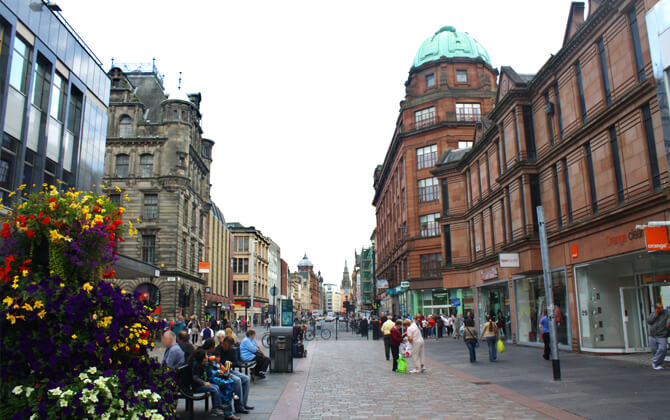
St Enoch is a convenient stop for the St Enoch Centre, Argyle Street, and the busy city-centre atmosphere.
Cowcaddens is useful for reaching the Tenement House area and nearby central streets.
Ibrox is the station for Rangers Football Club and is especially handy on match days.
Kelvinbridge puts you close to Great Western Road, Byres Road, the River Kelvin area, and plenty of cafés, bars, and shops in the West End.
Kelvinhall is the stop for Kelvingrove Museum and Art Gallery, and it also gives access to nearby green space.
- St Enoch for shopping and Argyle Street
- Cowcaddens for the Tenement House area
- Ibrox for Rangers Football Club
- Kelvinbridge for the West End and Byres Road
- Kelvinhall for Kelvingrove Museum and nearby parkland