Public transportation in Glasgow includes buses, local trains, taxis, airport links, and the Glasgow Subway. Together, they form a practical city transport system for getting around the centre, the West End, the Southside, nearby suburbs, and onward destinations across Scotland and the UK. The network is easy to use for everyday travel, and the Subway in particular is a quick way to avoid road traffic.
| Key | Information |
|---|---|
| Main public transport modes | Bus, train, subway, taxi, airport bus links, cycling |
| Main rail stations | Glasgow Central and Glasgow Queen Street |
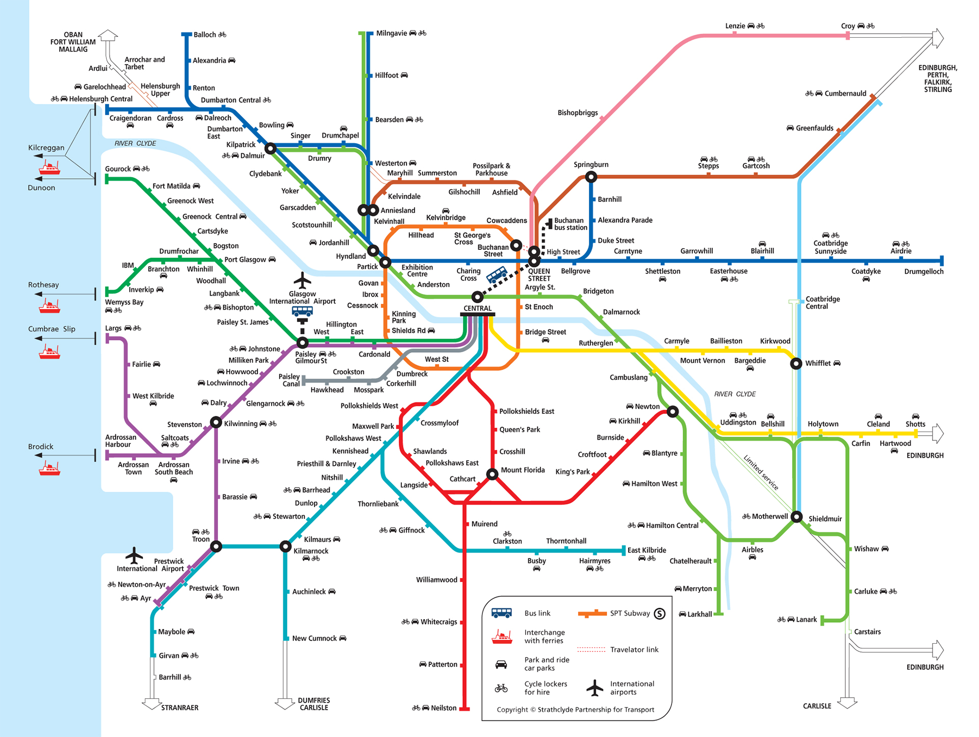
| Subway system | Single circular route with 15 stations |
| Subway route length | About 10.5 km / 6.5 miles |
| Subway operator | Strathclyde Partnership for Transport (SPT) |
| Rail operator | ScotRail |
| Main bus hub | Buchanan Bus Station |
| Airport city link | Glasgow Airport Express Service 500 |
Map of Public Transportation In Glasgow
Map of Public Transportation In Glasgow showing different lines and stations. Click on the map to enlarge it or download the map in PDF format.
Getting Around in Glasgow
Glasgow has a strong public transport system, so getting around the city is usually straightforward. The city centre is well served by buses, train stations, and the Glasgow Subway, and many key transport links are within walking distance of central areas.
Buses and coaches
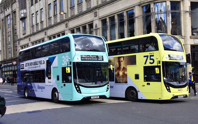
Buses are the most common form of local transport in Glasgow. Most routes run through the city centre, and First Group is the largest operator in the area. For everyday city transport, buses are often the easiest option.
For longer trips, coaches are often one of the cheaper choices. Many services leave from Buchanan Street Bus Station, close to central Glasgow. Operators mentioned in the route network include Scottish Citylink, National Express, and Stagecoach.
Underground trains
The Glasgow Subway, sometimes called the Glasgow Underground, is a simple circular system with 15 stations. It serves the city centre, the West End, and the South Side, making it a fast option for short urban trips.
It is also one of the oldest underground railway systems in the world. Even now, it remains a popular way to travel quickly and skip road congestion.
Trains
Glasgow also has an extensive local rail network operated by ScotRail. The two main stations, Glasgow Central and Glasgow Queen Street, are both close to the city centre and provide important connections across Scotland and beyond.
Glasgow Central mainly serves southern Scotland and mainline routes to England. Glasgow Queen Street handles services to Edinburgh, Aberdeen, Dundee, and the Highlands. For route timetable and train schedule information, passengers typically check ScotRail and SPT before travelling.
Various modes of public transport in Glasgow
Glasgow’s transport system includes air, rail, road travel, and an underground metro line. The city was also served by trams until 1962. Today, public transport still plays a major role in daily travel, alongside heavy car use from commuters coming in from surrounding areas.
Central Glasgow is easier to navigate than many cities thanks to its grid street pattern, laid out in the early 19th century. Even so, roads are busy, and public transport remains an important alternative.
Buses
Bus travel is a major part of transportation in Glasgow. The city council has invested in bus corridors, real-time information, and priority measures on key routes. Major operators include First Glasgow, McGill’s Bus Services, Stagecoach Glasgow, and West Coast Motors. Buchanan Bus Station, run by SPT, handles both local and long-distance bus services.
Rail
Glasgow has one of the densest heavy-rail networks in the UK outside London, with 186 stations across Greater Glasgow. ScotRail runs the suburban system, centered on Glasgow Central and Glasgow Queen Street. Central mainly serves routes south of the city and links to the rest of the UK, while Queen Street mainly serves the north of Scotland. Both also have underground platforms for east-west services.
Subway
The Glasgow Subway is one of only three British metropolitan areas with an underground metro system. Opened in 1896 and substantially modernized in 1977, it has a single circular route and is widely known as the Clockwork Orange. There has been no expansion beyond the original line, though extension plans have been discussed.
Air travel
Glasgow has two international airports and is also served by a seaplane terminal. Glasgow International Airport is the closest airport to the city and handles most air traffic, including flights across the UK, Europe, the Americas, and the Middle East.
Cycling and park and ride
Cycling is supported by a city bike hire scheme and several National Cycle Network routes. SPT and ScotRail also operate park and ride locations across the wider area, including three at Subway stations and many more at railway stations.
Historical transport
Glasgow once had an extensive tramway network, which was phased out and ended on 4 September 1962. The city also had a small trolleybus system between 1949 and 1967. Tram reintroduction has been proposed more than once, but no trams currently operate.
Bus service in Glasgow
Bus services are a core part of public transport in Glasgow. Strathclyde Partnership for Transport coordinates services across the region and works to improve local transport. SPT also runs specialist services, including the bookable MyBus option, which provides door-to-door transport in certain areas.
After deregulation, bus operators can introduce, change, or withdraw services with the required notice. In Scotland, socially necessary non-commercial services may be awarded by competitive tender. Glasgow City Council has also invested in bus corridors with real-time information and priority measures on major routes.
The largest bus operators in Glasgow are:
- First Glasgow
- McGill’s Bus Services
- Stagecoach Glasgow
- West Coast Motors
Buchanan Bus Station, owned and operated by SPT, is a key terminus for both local and long-distance bus services.
SPT also provides updates on subsidised service disruptions, including diversions, delays, and closures. For airport travel, the Glasgow Airport Express runs 24 hours a day. There is also a station bus link connecting Glasgow Central, Glasgow Queen Street, and Buchanan Bus Station with zero-emission buses.
Train service in Glasgow
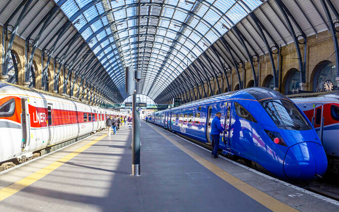
Glasgow has one of the densest heavy-rail networks in the UK outside London, with 186 stations across Greater Glasgow. The suburban rail system is operated by ScotRail and centered on Glasgow Central and Glasgow Queen Street.
Glasgow Central mainly serves routes to the south of the city, including Lanarkshire, Ayrshire, and onward links to the rest of the UK. Glasgow Queen Street mainly serves trains to the north of Scotland. Both stations also have underground platforms for east-west services across the city.
Local rail services connect Glasgow with suburbs and the wider West of Scotland, and many nearby towns can be reached by train. Service levels vary by route, and some stations close on Sundays. Free timetables are available at stations and online from ScotRail, while SPT also provides train schedule and timetable information.
Tickets can usually be bought in advance at station booking offices, or on the train from the conductor if the booking office is closed. Park and ride is available at suburban stations, making it easier to leave a car outside the centre and continue by rail.
Glasgow once had two other terminus stations, St Enoch and Buchanan Street, but both were removed in the 1960s after the Beeching cuts. Today, rail remains a central part of the city’s public transport system and connects closely with buses and the Subway.
Taxi in Glasgow
There is no shortage of taxis in Glasgow, and they can be useful when public transport does not cover a journey well. They are especially practical late at night, after the last train or after bus services become less frequent.
Glasgow Taxis operates the city’s traditional black cabs as well as 5- and 6-seater vehicles. You can hail them on the street when the yellow light is on, book by phone, or use the Glasgow Taxis app. Credit cards are accepted.
Saltire Private Hire focuses on airport transfers and can also arrange bespoke tours in Glasgow and beyond. For a pre-booked longer trip, that can be a comfortable option.
Many taxis have wheelchair access, which is helpful for elderly passengers and people with reduced mobility. Visitors often find taxi drivers useful for local tips as well.
For a street pick-up or taxi rank, look for the illuminated taxi sign on the roof. App-based booking is also available through services mentioned in the source material, such as Gett. As for cost, taxis are usually pricier than public transport, particularly during peak hours and holiday periods.
Glasgow Subway system
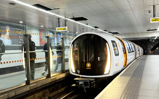
The Glasgow Subway is an underground light metro system in Glasgow, Scotland. It opened on 14 December 1896 and is the third-oldest underground metro system in the world, after London’s Metropolitan Railway and the Budapest Metro. The system was originally called the Glasgow District Subway, later became the Glasgow Subway Railway, then the Glasgow Underground in 1936, and officially returned to the name Subway in 2003 under SPT.
The system follows a single circular route of about 10.5 km (6.5 miles), with 15 stations and two service directions called the Outer Circle and Inner Circle. In practice, these are clockwise and anticlockwise trains on the same loop in separate tunnels. The line has never been expanded beyond its original route plan.
The Subway uses the unusual narrow gauge of 4 ft (1,219 mm), and its tunnels are smaller than those of many other metro systems. Stations have different layouts, including island platforms, side platforms, and mixed arrangements such as at Hillhead. The running lines are fully underground, while the maintenance depot at Broomloan Road is above ground.
The system is owned and operated by SPT and carried 12.7 million passengers in 2019–20. Since 2007, it has been policed by the British Transport Police.
History and modernisation
The Glasgow District Subway Company was incorporated by the Glasgow District Subway Act 1890, and construction began in 1891. The original line was cable-hauled and opened in 1896. It was later electrified, and in 1977 the route closed for a major modernization program.
That work included tunnel repairs, station rebuilding and enlargement, a new electrical supply, updated ticketing, and the introduction of automatic train operation. The modernised system reopened on 16 April 1980.
A further upgrade program began in the 2000s, including station improvements, better accessibility, and new driverless trains. The first passenger service with the new trains ran on 11 December 2023, and the second-generation fleet was fully withdrawn on 28 June 2024.
Connections, fares, and service
The Subway connects with the suburban rail network at Partick, and Buchanan Street station has a moving walkway to Queen Street mainline station. Glasgow Central and Argyle Street are also a short walk from St Enoch. Many Subway stations connect with bus routes too.
The system uses a flat fare rather than distance-based pricing. Tickets are available as paper tickets or on a Subway Smartcard, with slightly lower fare options on the smartcard. This is useful if you want a pass-style option for repeated travel, though the source only confirms smartcard top-ups and discounted fares.
The service timetable runs from 06:30 to 23:40 Monday to Saturday and from 10:00 to 18:12 on Sunday. Off-peak frequency is every 6 to 8 minutes on both circles, with more frequent trains at peak times.
For quick reference, here are the main operating hours and service timings.
| Service detail | Timings |
|---|---|
| Starting time, Monday to Saturday | 06:30 |
| Closing time, Monday to Saturday | 23:40 |
| Starting time, Sunday | 10:00 |
| Closing time, Sunday | 18:12 |
| Off-peak frequency | Every 6 to 8 minutes |
| Peak service | More frequent than off-peak |
The stations list below gives the full set of Glasgow Subway stops.
| Station | Details |
|---|---|
| Buchanan Street | City centre station with a moving walkway link to Queen Street mainline station |
| St Enoch | Short walk to Glasgow Central and Argyle Street railway stations |
| Partick | Interchange with the suburban rail network |
| Hillhead | Station with a mixed platform layout |
| Other Glasgow Subway stations | The system has 15 stations in total on a single circular route serving central Glasgow, the West End, and the South Side |
Airport Connections
Glasgow Airport is well connected to the city centre and surrounding areas, with several transport options.
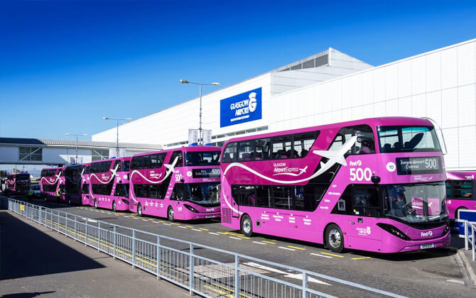
By bus, the Glasgow Airport Express Service 500 is the official 24-hour route between the airport and the city centre. It departs from Stance 1 at the airport and Buchanan Bus Station, Stance 46, in the city. Journey time can be as little as 15 minutes, and free WiFi is available. Other buses and coaches also stop outside the terminal.
By train, the nearest station is Paisley Gilmour Street, a little over 1.6 km / 1 mile from the terminal. From there, you can continue to the airport on McGill’s 757 bus service.
By taxi, cabs are available at the taxi rank outside the terminal building for a direct trip into the city.
Cycling and walking are also possible using the local footpath network and the National Cycle Network.
For drivers, the airport has direct motorway access, with the M8 running past Glasgow Airport.
Useful information
Glasgow is a very walkable city, especially in the centre, where many attractions and transport links are close together. It is often easiest to combine walking with local transport rather than relying on one mode alone.
For cycling, Glasgow has a cycle hire scheme run by Voi. Sustrans also provides route ideas for rides in the city and nearby areas.
The Glasgow Subway is one of the easiest ways to get around the city centre, the West End, and the Southside. At peak times, trains run every 4 minutes, and the full running time for one circuit is about 24 minutes across all 15 stations. You can buy a single ticket or use a Subway Smartcard if you are staying a few days and want better fare value with top-ups.
Glasgow Central connects the city by rail to the south and west, while Glasgow Queen Street serves routes to the north and east, including Edinburgh. If you need to move between the two, they are around a 12-minute walk apart. ScotRail also offers a bus link service.
A Roundabout ticket gives unlimited travel for one day on ScotRail and Subway services and covers more than 110 stations in the Greater Glasgow area. That makes it a practical day pass for visitors planning several trips.
First Bus Glasgow operates more than 80 routes across the city. Ticket options vary by length of stay: a day ticket gives unlimited travel in your chosen area for the day, while a weekly ticket can be more cost-effective for longer visits. The First Bus app can also be used to buy and store tickets, plan journeys, and check the next bus.
For sightseeing, the open-top City Sightseeing Glasgow bus tour is a convenient way to see the main attractions. The red route covers the centre and West End, including the Riverside Museum, Kelvingrove Museum and Art Gallery, and the University of Glasgow. The yellow route serves the east and south of the city, with stops including the Barrowlands, Glasgow Science Centre, and The Burrell Collection. The full tour takes about 90 minutes, and each bus has one dedicated wheelchair space on the lower deck.
Taxi options include Glasgow Taxis and Saltire Private Hire. If you are driving, remember that vehicles drive on the left, seat belts are compulsory, and Glasgow has a Low Emission Zone in the city centre. Vehicles that do not meet the required standards may face a penalty charge.
Nearby Attractions
Glasgow is easy to explore on foot, especially in the city centre, where the street layout makes walking simple and enjoyable.
For longer trips, public transport makes it easy to reach many of the city’s best-known attractions. The Subway is especially useful for the city centre, West End, and Southside, with stations serving areas such as Kelvinbridge, Hillhead, and Partick. It is a handy option for places like Kelvingrove, the University of Glasgow, and Buchanan Street.
Buses are also practical, with frequent routes connecting major visitor spots. The City Sightseeing Glasgow tour covers attractions including George Square, Kelvingrove Art Gallery and Museum, the Riverside Museum, Glasgow Science Centre, and The Burrell Collection.
Train travel works well for day trips and places beyond the centre. From Glasgow Central and Glasgow Queen Street, you can connect to destinations such as Balloch, Paisley, and Partick without needing a car.
If you want something flexible, the Voi cycle hire scheme can be a good fit for short trips and for combining sightseeing with local transport.