Oslo has a well-integrated public transportation system that makes it easy to move around the city and nearby areas. Ruter manages ticketing and travel information for metro, tramway, bus, ferry, and local train services within Oslo, while Vy handles many regional rail connections. The network is designed to support public transport, walking, and cycling over private car use, so getting around is usually simple, practical, and safe.
| Key | Information |
|---|---|
| Main local transport authority | Ruter |
| Transport modes covered | Metro, trams, buses, ferries, and local trains within Oslo |
| Regional operator mentioned | Vy |
| Journey planner mentioned | Entur |
| Travel focus | Public transport, walking, and cycling over private car use |
| Airport links mentioned | Oslo Airport Gardermoen and Torp Airport |
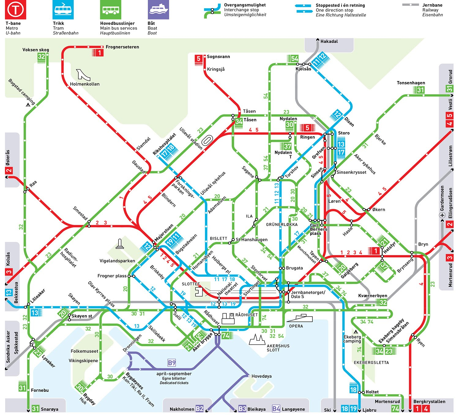
Public Transportation System In Oslo Map
Map of Public Transportation. Click on the map to enlarge it or download the Public Transportation System In Oslo map in PDF format.
Local Trains in Oslo
Local trains are part of Oslo’s wider public transport system, and Ruter manages ticketing and fare integration together with metro, tram, bus, and ferry services. That shared system keeps travel straightforward, especially if you need to switch between modes on one route.
Oslo Central Station, or Oslo S, is the main rail hub. Vy operates the Oslo Commuter Rail, which links the capital with six counties in Eastern Norway. Regional and express trains also connect Oslo with places such as Drammen, Lillehammer, Halden, Gothenburg, and Stockholm.
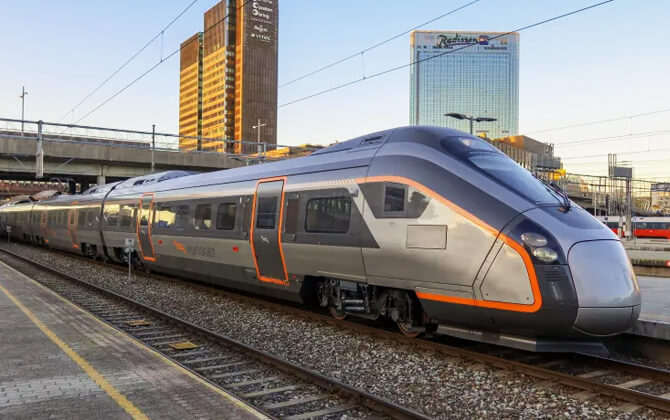
For airport travel, Flytoget runs a high-speed path train connection between Drammen, Oslo, and Gardermoen Airport. If you are heading beyond the city centre or combining Oslo with nearby destinations, local trains are a useful part of the route plan and the same integrated ticket system.

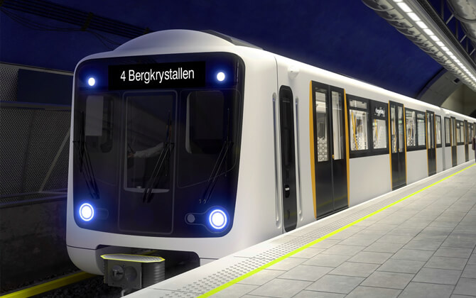
T-Bane or Metro Service in Oslo
The Oslo Metro, known as the T-bane, is the city’s rapid transit system. It is operated by Sporveien T-banen on behalf of Ruter. The network has five lines, stretches for 85 kilometres (52.8 miles), and includes 101 stations, with 17 underground or indoor stations.
The system serves 14 of Oslo’s 15 boroughs and also reaches Bærum on the Kolsås and Østerås branches. In 2016, annual ridership reached 118 million, underlining how central the T-bane is to transportation in Oslo.
The history of the metro goes back to 1898, when the Holmenkollen Line opened. The branch to Røa followed in 1912, and in 1928 Oslo became the first Nordic city with an underground rapid transit line, when service reached Nationaltheatret. Another key moment came in 1993, when trains began running through the city in the Common Tunnel, linking the eastern and western networks. The Ring Line opened in 2006, and the current route network was introduced on 3 April 2016 with the new connection tunnel from Økern to Sinsen and the opening of Løren station.
Today, all trains use MX3000 rolling stock, which replaced the older T1000 fleet between 2006 and 2010.
Network and service pattern
All five lines run through the Common Tunnel and connect the main transfer points in the city centre. The base frequency is four trains per hour on all lines. On weekdays between 07:00 and 19:00, line 2 and the eastern section of line 3 run more often, with eight trains per hour.
The metro is fully integrated with the rest of Oslo public transport. Tickets are valid across the T-bane, tram, bus, ferry, and Oslo Commuter Rail within the same zone, which makes transfers easy and keeps the timetable and schedule practical for everyday travel.
Stations and travel experience
The T-bane has 101 stations in total, and 17 are underground or indoors. In the city centre, stations are close to major job areas and connections with other transport modes. Outside central Oslo, stations have been unstaffed since 1995 and usually include ticket machines for fare purchase.
Every station is marked with a blue T in a circle, so the stations map is easy to follow at street level. For many trips, the T-bane is the fastest way across the city, whether you are commuting between central districts or heading out toward the suburbs.
| Station | Details |
|---|---|
| Nationaltheatret | Historic underground metro station; service opened in 1928 |
| Løren | New station added with the 2016 network update |
| Kolsås | Branch in neighbouring Bærum |
| Østerås | Branch in neighbouring Bærum |
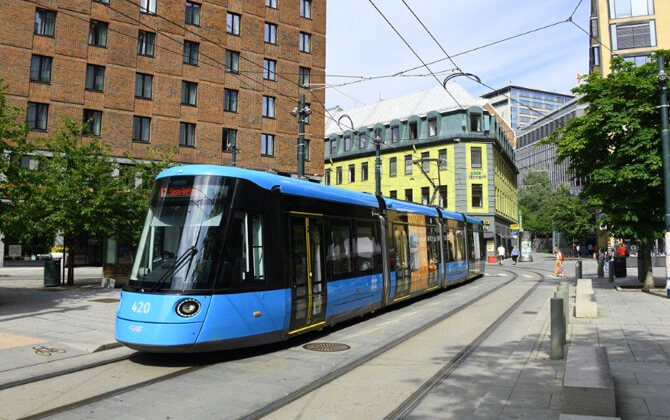
Trams in Oslo
Oslo’s tramway, known locally as Trikken, is a core part of the city transport system. It has six lines, 99 stops, and daily ridership of about 132,000. Operations are handled by Sporveien Trikken AS, while Ruter manages the wider public transport framework, including ticketing.
The network uses standard gauge track and 750 V DC overhead power. Its main depot, workshops, and headquarters are at Grefsen, the terminus of lines 17 and 18. Another depot is located at Holtet on lines 13 and 19.
History
Oslo’s tram history began in 1875 with a short horse-drawn line between Homansbyen, Oslo West Railway Station, and Grønland. The network expanded to Grünerløkka in 1878. Electric trams arrived in 1894 on the Briskeby to Majorstuen line, and horse trams disappeared completely by 1900.
For years, the city had two tram companies, Grønntrikken and Blåtrikken, which merged in 1924. The network kept growing through the 1910s, 1920s, and 1930s, including the Ekeberg Line, built in stages between 1917 and 1941. It reached its greatest extent in 1939 with the opening of the line to Sinsen.
After World War II, closures followed as diesel bus services replaced many tram routes. In 1960, the city council decided to dismantle the tram system, but that decision was reversed in 1977. New articulated trams were then ordered, with the first SL79 units arriving in 1982. The network expanded again in the 1990s, and later fleet renewal brought in SL95 trams.
In 2003, the tram system was separated into a new company, Oslotrikken, later renamed Trikken. Passenger demand has risen strongly since then, although vehicle shortages have limited further expansion.
Routes
As of 2021, Oslo had six tram lines running daily. The usual frequency was every 10 minutes, with a 20-minute timetable in the late evening and on weekends. In central areas where several lines overlap, trams can come every 5 minutes, so the schedule feels very frequent.
Two sections operate more like light rail than street-running trams. The Ekeberg Line serves the southern hillside route to Ljabru and is used by lines 13 and 19. The Lilleaker Line serves the western route to Lilleaker and is used by line 13.
The current route network includes lines 11, 12, 13, 17, 18, and 19. Lines 11, 12, and 19 are coordinated, and lines 17 and 18 are paired at Grefsen. The network is color-coded on maps, although destination displays are now digital.
Line 13 is the only tram line that continues to Lilleaker. The former extension to Bekkestua was cut back in 2024 because the new SL18 trams are not certified to run on metro track. Major interchange points include Majorstuen, Jernbanetorget, and Storo.
Rolling stock
As of 2026, the fleet consists entirely of 87 SL18 trams, numbered 401 to 487. These CAF Urbos 100 vehicles are bi-directional, five-segmented, and 100% low-floor. They replaced older tram types and improved accessibility across the system.
There are also heritage trams used on special occasions. In summer, tram no. 70 with trailer no. 647 runs scheduled Sunday trips. It was built in Hamburg in 1913 for Grønntrikken and stayed in regular passenger service until 1968.
Incident
On 29 October 2024, an SL18 tram derailed and crashed into an Eplehuset store on Storgata. Four people, including the driver, were injured, and the driver was later charged in connection with the accident.
Even so, the tram remains a major part of city transport in Oslo, especially for short and medium trips around the inner city.
| Station | Details |
|---|---|
| Grefsen | Terminus for lines 17 and 18; depot area |
| Holtet | Depot location on lines 13 and 19 |
| Ljabru | Southern end of the Ekeberg Line route |
| Lilleaker | Western end served by line 13 |
| Bekkestua | Former extension curtailed in 2024 |
| Majorstuen | Important interchange point |
| Jernbanetorget | Important interchange point in central Oslo |
| Storo | Important interchange point |
Public bus network in Oslo
Oslo has an extensive bus network, and buses fill in the gaps left by metro and tram lines. The city has 50 inner-city bus routes, not including services that connect with greater Akershus.
In practice, buses are the final layer of the public transport system, reaching areas that rail services do not cover directly. On some of the busiest routes, frequency is extremely high. Route 31 to Fornebu, for example, can have around 50 departures per hour toward the peninsula during peak periods.
Bus travel is part of the same Ruter ticket and fare system used for metro, tram, ferry, and local train services, which makes route planning much easier.
| Station | Details |
|---|---|
| Fornebu | Served by busy bus route 31 with very frequent peak departures |
Passenger ferry service in Oslo
Passenger ferries are an important part of Oslo’s local transport network, although a standard Ruter ticket is valid only on a limited number of ferry and boat services. These routes mainly serve zone 1 destinations such as Langoyene, Gressholmen, Bleikoya, Nakholmen, Lindoya, and Hovedoya.
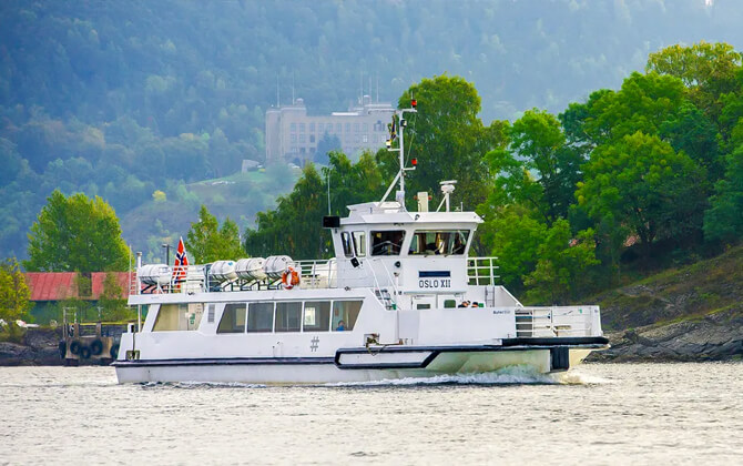
There are also commuter ferry connections from Oslo to Nessoden and several towns farther down the Oslofjord. Ferry services run throughout the year, but some routes are seasonal. Route 94 between Langoyene and Oslo, for instance, operates only in summer.
The Norwegian Maritime Service is responsible for ferry operations.
| Station | Details |
|---|---|
| Langoyene | Zone 1 ferry destination; route 94 runs in summer only |
| Gressholmen | Zone 1 ferry destination |
| Bleikoya | Zone 1 ferry destination |
| Nakholmen | Zone 1 ferry destination |
| Lindoya | Zone 1 ferry destination |
| Hovedoya | Zone 1 ferry destination |
| Nessoden | Served by commuter ferries from Oslo |
Airport Connections
There are several practical ways to travel between Oslo Airport Gardermoen and the city. From Oslo Central Station, Oslo Congress Center is also close enough to reach on foot or with a short tram or bus ride.
From Oslo Airport to the city
The fastest route is by train, with a running time of about 20 minutes to Oslo Central Station, also called Oslo S or Jernbanetorget.
| Service detail | Timings |
|---|---|
| Flytoget Airport Express Train | Departs every 10 minutes from Track 3; about 20 minutes to Oslo Central Station |
| Vy trains | Depart from Track 4; slower and less frequent than Flytoget |
| Flybussen Airport Express Bus | Departs every 20 minutes from platform 12; about 70 minutes to the city center |
| Taxis | Usually 40 to 50 minutes depending on traffic |
- Flytoget Airport Express Train: the ticket price is 252 NOK, about $23 USD. Tickets can be bought in the Flytoget app or on its website, or by tapping the contactless card reader next to the escalator down to Track 3.
- Vy trains: the fare is 129 NOK, about $12 USD. Tickets can be bought in the Vy app, on the Vy website, in the Ruter app, or at ticket machines at the airport and Oslo Central Station. Vy airport trains are included in the Oslo Pass.
- Flybussen Airport Express Bus: the price is 259 NOK, about $24 USD. Tickets can be bought on the Flybussen website or directly on the bus.
- Taxis: fixed prices to downtown Oslo are typically around 900 NOK, about $83 USD.
From Oslo Central Station to the venue
Oslo Congress Center at Youngs gate 21 is about 650 meters (0.65 kilometres / 0.4 miles) from Oslo Central Station on foot.
If you want a shorter walk, take tram lines 12, 15, 17, or 18, or bus 54 to Storgata. From there, it is around 250 meters (0.25 kilometres / 0.16 miles) to the venue.
| Station | Details |
|---|---|
| Oslo Central Station (Oslo S) | Main rail hub and airport transfer point |
| Jernbanetorget | Alternative name used for Oslo Central Station area |
| Storgata | Stop for tram lines 12, 15, 17, 18 and bus 54 near the venue |
Public transport in Oslo
Oslo’s public transport system includes metro, buses, trams, trains, and ferries, all using the same ticket structure. Tickets should be bought and activated in the Ruter app before boarding. The city does not use a general tap-and-go bank card system for public transport.
Most trips within the city require a zone 1 ticket. Travel to and from Oslo Airport Gardermoen requires a ticket valid for zones 1, 2Ø, 3Ø, and 4N. The Oslo Pass also includes public transport within Oslo and travel to and from the airport.
Physical ticket sales points are available through Ruter sales outlets.