Calgary CTrain is the city’s light rail system in Calgary, Alberta, Canada, operated by Calgary Transit as part of the local public transport network. It currently has two lines, the Red Line and the Blue Line, and remains a core part of transportation in Calgary for daily commuting and downtown travel. Service began on May 25, 1981, and the system has expanded steadily with the city. In 2024, it recorded 94,097,200 rides, and about 398,100 weekday rides were reported in the first quarter of 2025. The downtown section runs along 7th Avenue South at street level and works as a zero-fare zone, while trains draw power from overhead wires through pantographs.
| Key | Information |
|---|---|
| System | Calgary CTrain light rail |
| Operator | Calgary Transit |
| Lines | Red Line and Blue Line |
| Opening date | May 25, 1981 |
| Route length | 59.9 kilometres (37.2 miles) |
| Downtown fare zone | Zero-fare zone on 7th Avenue South transit mall |
| Power supply | Overhead electric wires with pantographs |
| Ridership | 94,097,200 rides in 2024 |
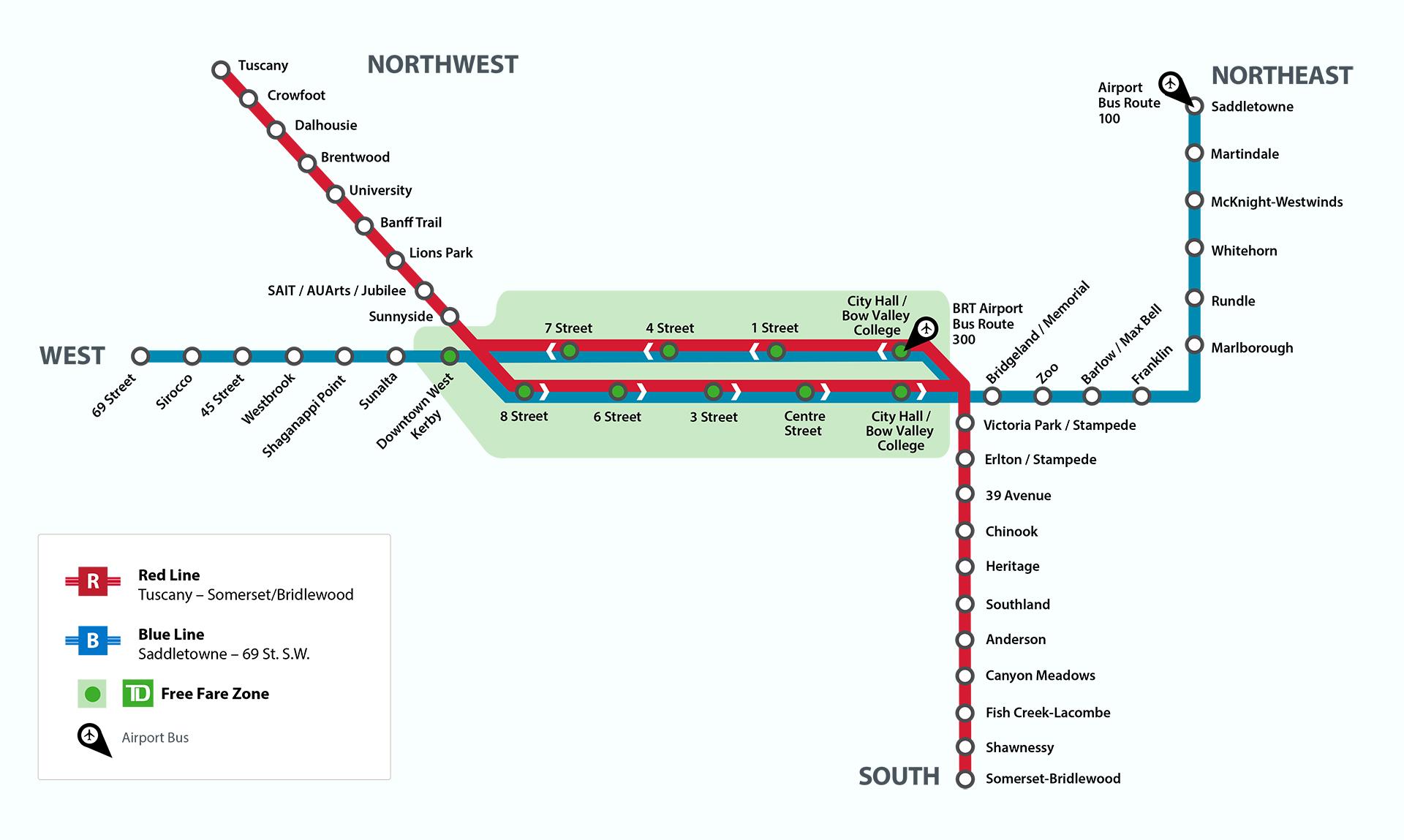
Calgary C-Train Map
Map of Calgary C-Train showing its lines and stations. Click on the map to enlarge it or download the Calgary C-Train map in PDF format.
Lines and Stations Overview
Calgary’s CTrain system has two main routes: Line 201, the Red Line, and Line 202, the Blue Line. Together they cover 59.9 kilometres (37.2 miles) and form the backbone of city transport across Calgary.
The Red Line serves the south and northwest, while the Blue Line links the northeast and west. Much of the route runs at grade on a dedicated right-of-way. In downtown Calgary, both lines share the 7th Avenue South transit mall, where the stations map doubles as a handy downtown people mover inside the free-fare zone.
The tracks split at both ends of downtown and continue into residential areas across the city. A small part of the network is underground, and some sections are elevated.
Red Line
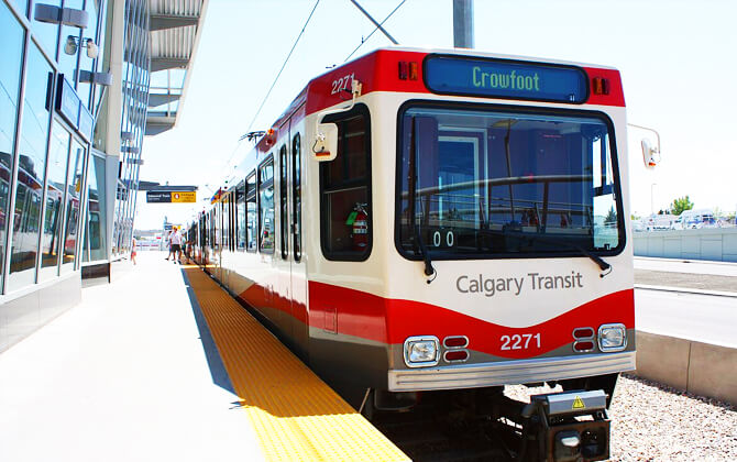
The Red Line, or Route 201, is the longer route. It runs between Tuscany in the northwest and Somerset–Bridlewood in the south. The full route is 35 kilometres (22 miles) long.
| Station | Details |
|---|---|
| Tuscany | Northwestern terminus of the Red Line |
| Crowfoot | Red Line station in the northwest |
| Dalhousie | Red Line station in the northwest |
| Brentwood | Red Line station in the northwest |
| University | Red Line station serving the university area |
| Banff Trail | Red Line station |
| Lions Park | Red Line station |
| SAIT/AUArts/Jubilee | Red Line station |
| Sunnyside | Red Line station near downtown |
| Victoria Park/Stampede | Red Line station near Stampede grounds |
| Erlton/Stampede | Red Line station |
| 39 Avenue | Red Line station |
| Chinook | Red Line station |
| Heritage | Red Line station |
| Southland | Red Line station |
| Anderson | Red Line station |
| Canyon Meadows | Red Line station |
| Fish Creek–Lacombe | Red Line station |
| Shawnessy | Red Line station |
| Somerset–Bridlewood | Southern terminus of the Red Line |
Blue Line
The Blue Line, or Route 202, is 25.7 kilometres (16.0 miles) long. It serves the northeastern and western parts of Calgary and shares the downtown corridor with the Red Line before branching out.
| Station | Details |
|---|---|
| 69 Street | Western terminus of the Blue Line |
| Sirocco | Blue Line station |
| 45 Street | Blue Line station |
| Westbrook | Blue Line station |
| Shaganappi Point | Blue Line station |
| Sunalta | Blue Line station |
| Downtown West–Kerby | Blue Line downtown station |
| Bridgeland/Memorial | Blue Line station |
| Zoo | Blue Line station |
| Barlow/Max Bell | Blue Line station |
| Franklin | Blue Line station |
| Marlborough | Blue Line station |
| Rundle | Blue Line station |
| Whitehorn | Blue Line station |
| McKnight–Westwinds | Blue Line station |
| Martindale | Blue Line station |
| Saddletowne | Northeastern terminus of the Blue Line |
Active and Former Stations
The current stations list covers the active Red and Blue Line network across the northwest, south, west, northeast, and downtown segments. Over time, a few former downtown stations were decommissioned and replaced as the system evolved.
| Station | Details |
|---|---|
| Active stations | Serve the present CTrain network across multiple parts of Calgary |
| 3 Street SE | Former downtown station |
| Olympic Plaza | Former downtown station |
| 10 Street SW | Former downtown station |
This station structure reflects how the route plan grew from a downtown corridor into a wider light rail system.
Schedule and Frequency of Trains
The CTrain operating hours are from 4:00 am to 1:00 am. These opening hours and closing time make it useful for both early commuters and late-evening trips.
| Service detail | Timings |
|---|---|
| Daily operating hours | 4:00 am to 1:00 am |
| Morning peak frequency | Every 4 to 7 minutes |
| Midday frequency | Every 10 minutes |
| Afternoon peak frequency | Every 10 minutes |
| Evening frequency | Every 15 minutes |
| Weekend frequency | Every 10 to 15 minutes |
For many riders, the most useful timetable detail is frequency rather than a fixed train schedule. Morning peak service runs every 4 to 7 minutes, then changes to 10-minute intervals at midday and during the afternoon peak. In the evening, trains run every 15 minutes.
At weekends, schedule today and timings today can vary between 10 and 15 minutes depending on demand. If you need the latest route timetable, Calgary Transit advises using the Plan a Trip or Next Ride tools on its website, or the Transit app for live updates.
There are no planned CTrain service changes mentioned at this time. One temporary note in the source states that on Good Friday, April 3, and Easter Sunday, April 5, buses, CTrains, and On Demand operate on a Sunday level of service.
Fare Structure and Ticketing
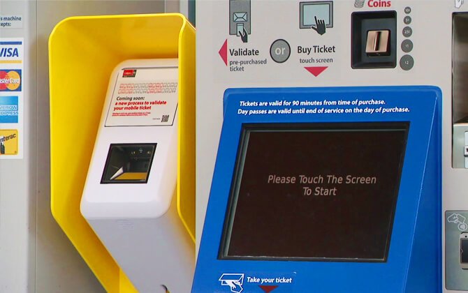
Calgary CTrain uses a flat fare structure, so the fare, ticket price, and travel cost do not depend on distance. Tickets can be bought in advance from vendors, at station vending machines, or through the My Fare app and the Transit app. There is no fare calculator listed in the source material.
| Fare Type | 2026 Rate |
|---|---|
| Adult cash fare, valid for 90 minutes | CAD 4.00 (USD 4.00) |
| Adult tickets, book of 10 | CAD 40.00 (USD 40.00) |
| Youth cash fare, valid for 90 minutes | CAD 2.65 (USD 2.65) |
| Youth tickets, book of 10 | CAD 26.50 (USD 26.50) |
| Children 12 and under | Free |
Tickets are valid for 90 minutes on both the CTrain and bus network. If you buy tickets in advance, they must be validated at a ticket vending machine before entering the fare-restricted zone. A ticket purchased at a station machine becomes valid right away and cannot be saved for later use beyond the 90-minute window.
| Pass Type | 2026 Rate |
|---|---|
| Adult day pass, valid until end of service | CAD 12.65 (USD 12.65) |
| Adult monthly pass, valid for 1 calendar month | CAD 126.00 (USD 126.00) |
| Youth day pass | CAD 9.25 (USD 9.25) |
| Youth monthly pass | CAD 86.00 (USD 86.00); CAD 92.00 (USD 92.00) starting September 2026 |
Passes allow unlimited travel during their validity period. The Weekend Group Day Pass costs CAD 18.00 (USD 18.00) and is sold only on Saturdays and Sundays. It covers unlimited travel for a group of up to two adults and up to five people over age 12, while children 12 and under ride free. The group must travel together, and one member must show the pass when asked. It is available in My Fare, in the Transit app, and from station vending machines, but it is not valid for CTA trips.
| Other Passes | 2026 Rate |
|---|---|
| Regular Seniors Annual Transit Pass, ages 65 and older | CAD 169.00 (USD 169.00) |
| Low Income Seniors Annual Transit Pass, ages 65 and older | CAD 34.00 (USD 34.00) |
| Low Income Monthly Pass | Cost is determined based on income |
If you transfer from the CTrain to a bus, show your validated ticket to the bus driver. In the My Fare or Transit app, validate your ticket before boarding the bus or entering the fare-restricted zone. On buses, you can also pay with cash or a single ticket and ask the driver for a transfer if needed.
Pass Options
Calgary Transit offers several pass options depending on how often you ride. A day pass is valid until the end of service on the day it is activated, while a monthly pass covers one calendar month.
For adults aged 18 and older, the day pass costs CAD 12.65 (USD 12.65) and the monthly pass costs CAD 126.00 (USD 126.00). Youth aged 13 to 17 can get a day pass for CAD 9.25 (USD 9.25) and a monthly pass for CAD 86.00 (USD 86.00), rising to CAD 92.00 (USD 92.00) from September 2026.
The Weekend Group Day Pass costs CAD 18.00 (USD 18.00). It is valid on Saturdays and Sundays for unlimited travel for a group of up to two adults and up to five people over age 12, with children 12 and under riding free. The group must stay together, and the pass is not valid for CTA trips.
Senior riders can choose from annual pass options. The Regular Seniors Annual Transit Pass costs CAD 169.00 (USD 169.00), while the Low Income Seniors Annual Transit Pass costs CAD 34.00 (USD 34.00). A Low Income Monthly Pass is also available, with price based on income.
Pets ride free. Dogs are allowed if leashed, and other animals may travel free if they are in a carrier or cage.
Integration with Other Systems
The CTrain is closely integrated with Calgary Transit bus services, which makes local transport across the city much easier. For airport trips, Route 300 is available from City Hall Station, and Route 100 can be reached from McKnight–Westwinds and North Pointe stations.
A CAD 10.50 fare (USD 10.50) gives unlimited daily access to both buses and the CTrain for airport travel, including a return trip on the same day. At the airport, buses board at Gate 7 opposite Arrival Gate 2 and at Gate 32 opposite Arrival Gate 15.
The wider transport system also includes links with Airdrie ICE, which connects Calgary and Airdrie. It shares some stations with the network, though fares are separate.
These connections help the CTrain work as part of a broader city transport and public transportation system, not as a stand-alone rail line.
Interlinking of Lines
The CTrain network is built around the Red Line and Blue Line, which share the downtown alignment on the 7th Avenue South transit mall. That shared corridor is the main point where the two routes interlink.
The lines connect at several downtown stations, including 8 Street, 6 Street, 3 Street, and Centre Street. Other connected downtown stations named in the source include City Hall, 1 Street, 4 Street, and 7 Street.
Together, these shared stations make the downtown section function as the common spine of the system. Because this corridor sits inside the free-fare zone, passengers can move between downtown stops without paying a fare.
Airport Accessibility
Calgary International Airport is 17 kilometres (10.6 miles) from downtown Calgary. The CTrain does not go directly to the airport, but it provides a practical route with a transfer to city buses.
For airport access, Route 300 serves City Hall Station, while Route 100 serves McKnight Station and North Pointe Station. A CAD 10.50 fare (USD 10.50) includes unlimited daily travel on buses and the CTrain to and from the airport, including a same-day return trip. A valid monthly pass can be used for travel from the airport, but not for the return journey.
At the airport, buses can be boarded at Gate 7 opposite Arrival Gate 2 and Gate 32 opposite Arrival Gate 15. Tickets are sold at the airport’s Mac Stores near arrival gates 1 and 11, and from vending machines at gates 7 and 32. If paying cash, exact change is recommended.
YYC Calgary International Airport also offers barrier-free facilities and accessibility services. Airlines provide accessibility support from check-in to aircraft for departures, and from aircraft to the public pre-security area for arrivals. The airport recommends letting your airline, travel agent, or tour operator know about any accessibility needs when booking.
Accessible transport options at the airport include taxis, Calgary Transit, wheelchair accessible vehicles, rental cars, and hotel shuttles. Calgary Transit states that its CTrains and buses are accessible, with ramps and clearly marked accessible station entrances.
Parking Facilities
Most CTrain stations and several major bus terminals have Park and Ride lots for transit users. These include free parking and reserved parking spaces. Reserved station parking becomes free after 10:00 am on weekdays.
If you have more than one vehicle, including motorcycles, you can register up to five license plates and activate up to three at a time. Even then, only one vehicle may use the reserved spot at any given moment.
For safety, lots are patrolled regularly by Peace Officers. Parking enforcement is handled by the Calgary Parking Authority, and illegally parked vehicles may be ticketed or towed.
| Key | Information |
|---|---|
| Station parking | Available at most CTrain stations and several major bus terminals |
| Parking types | Free parking and reserved parking |
| Parking charges | Reserved parking is free after 10:00 am on weekdays |
| Parking charges per day | Not specified in the source |
| Vehicle registration | Up to five license plates registered, with up to three active at one time |
| Enforcement | Peace Officer patrols; ticketing or towing by Calgary Parking Authority |
Reserved parking maps and parking locations are available for many stations on the Red Line, NE, and West segments, as well as some community parking lots.
Guidelines, Suggestions, and Recommendations
Calgary Transit offers trip-planning tools through the YYC Transit app and its website. You can enter your starting point and destination, then choose whether you want to leave or arrive at a certain time. If needed, Customer Service can be reached at 403-262-1000.
Check the timetable and schedule before you travel, especially if you need a bus connection. It is smart to arrive around five minutes early at your stop, and 10 to 15 minutes before school starts if that is your destination. Trains and buses can run a little early or late, so a bit of extra time helps.
For live timings, the YYC Transit app uses onboard GPS. You can also use TeleRide at 403-974-4000 for bus arrival times, or TeleText by texting the stop number and bus number to 74000. Planned disruptions can also be checked online before you leave.
Maps help a lot too. The system map shows routes across the city, while route maps cover individual lines in more detail. Printed maps are available at Customer Service Centres, and digital versions are available online.
If you are new to the system, basic etiquette goes a long way. Let passengers get off before boarding, stand away from the curb, and keep your ticket, pass, or card ready. On buses, move toward the back if you are standing; on the CTrain, move toward the center so others can board more easily.
For safe travel, stay alert, keep headphones off at crossings and on platforms, and stand behind the yellow line while waiting. CTrain stations have help phones, and every train car has an intercom for emergencies.
It also helps to be considerate. Keep noise low, avoid blocking doors, clean up after yourself, and do not let bags take up extra seats. Dogs are allowed if leashed, and other animals must be in a carrier or cage.
Interesting Trivia
The CTrain began service on May 25, 1981, and has grown into one of the busiest light rail systems in North America. In 2024, it recorded 94,097,200 rides, and the source also notes about 279,200 weekday rides as of the third quarter of 2025.
About 45% of workers in Downtown Calgary use the CTrain to commute. The downtown section along 7th Avenue South also works as a zero-fare zone, which is unusual and very practical.
Outside downtown, trains can reach speeds of up to 80 km/h (49.7 mph), while the 7th Avenue corridor is limited to 40 km/h (24.9 mph). Only a small part of the system is underground or elevated.
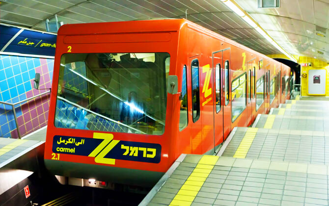
The rolling stock has a few interesting details. Calgary’s original fleet used Siemens-Duewag U2 vehicles, and the first Siemens SD-160 cars arrived in July 2001. Two U2 AC units bought in 1988 for trials later became Calgary cars 2101 and 2102, and car 2101 was eventually converted into the track inspection vehicle SCOUT.
In late 2015, Calgary Transit started running four-car trains to ease overcrowding. That raised capacity from 600 to 800 passengers per train, a 33% increase.
The Siemens S200 cars also stand out visually: the front was customized to resemble a hockey goalie’s mask. These cars introduced heated floors, air conditioning, and onboard video cameras.
History
Calgary’s rail transit story goes back to a 1967 transportation study that recommended a two-line metro system. In the 1970s, as costs rose and the city kept growing, Calgary moved away from heavy rail and toward light rail. A 1975 plan proposed a single line from downtown to Anderson Road, and City Council approved the project in May 1977.
The South Line opened on May 25, 1981, starting public CTrain service. Built in four years, it connected Anderson to Downtown with 16 stations and quickly became a key part of city transport. Oliver Bowen led the department that designed and built the original system.
Expansion followed through the 1980s. The Northeast Line opened in 1985, and the Northwest Line followed in 1987, in time for the 1988 Winter Olympics. By 1990, the network had reached 31 stations and more than 27 kilometres (16.8 miles) of track.
Construction picked up again in the early 2000s. The South Line was extended to Somerset-Bridlewood, more stations were added, and in 2012 the West LRT line opened between 69 Street and Sunalta, linking to the downtown terminus at 10 Street S.W., now Downtown West/Kerby. The Blue Line later extended north to Saddletowne, and Tuscany joined the Red Line in 2014. These projects brought the system to 45 stations and 59.9 kilometres (37.2 miles) of track.
The system also adapted to changing demand. Calgary Transit introduced new vehicles, upgraded technology, and began operating four-car trains in late 2015. It also worked through major challenges, including the 2013 flood and the COVID-19 pandemic.
The next major chapter is the Green Line. Phase 1 from Shepard to Eau Claire is described as the largest LRT project in Calgary’s history, with 13 stations and 18 kilometres (11.2 miles) of track. It is planned to link the southeast with downtown, connect with the Red and Blue Lines, and tie into three MAX rapid bus routes.
Planned Expansions
Calgary Transit’s long-term expansion plans point to a broader CTrain network, with RouteAhead acting as the main 30-year roadmap. The plan includes extensions to the existing Red and Blue lines and new corridors for west, north-central, and southeast Calgary.
For the Red Line, RouteAhead identifies a possible southward extension of about 3.5 kilometres (2.2 miles) to a future 210 Avenue SW station. For the Blue Line, the plan includes possible northeast expansion toward Calgary International Airport via a spur line, toward 128 Avenue NE, or potentially both. In the longer term, the Blue Line is also expected to extend past Stoney Trail.
Another major project is the Green Line, a separate route planned to run from north Calgary through downtown and into the southeast. It is designed as a separate line to avoid capacity limits on the downtown transit mall, with underground running through four downtown stations and the Beltline. It would connect to the Red and Blue lines at 7 Avenue SW.
On the north leg, planned communities include Country Hills, Coventry Hills, Harvest Hills, and Panorama Hills, with a possible future extension to Airdrie. In the southeast, the route is expected to continue along 52 Street SE, with proposed stations at Douglasglen, Shepard, Prestwick, McKenzie Towne, Auburn Bay/Mahogany, and Health Campus/Seton.
RouteAhead also mentions the future SETWAY transit-only right-of-way as an interim southeast corridor, along with a second northern line that still awaits final alignment decisions. Separate long-term plans also include a downtown-to-airport connection that could begin as a Route 202 spur.
Beyond new routes, system upgrades are part of the expansion plan too. These include continuing the shift to four-car trains, replacing older Siemens-Duewag U2 vehicles with Siemens S200 cars, and refurbishing platforms and downtown infrastructure to support longer trains and higher ridership.
Sightseeing Opportunities
Calgary’s CTrain is a straightforward way to explore the city. The Red Line and Blue Line connect neighbourhoods, shopping areas, cultural sites, and major event venues, so it works well for both daily transport and sightseeing.
In downtown Calgary, the shared Transit Mall stations along 7th Avenue make it easy to move between both lines. Because these stops are in the Free Fare Zone, short hops through the city centre are especially convenient.
Notable places along the Red Line
| Station | Details |
|---|---|
| Sunnyside Station | Access to Kensington Village, known for shops, cafes, and restaurants |
| SAIT / AUArts / Jubilee Station | Connects to education and culture; also a starting point for Bus 300 to Calgary International Airport |
| Lions Park Station | Close to North Hill Centre and the Louise Riley branch of the Calgary Public Library |
| Banff Trail Station | Near McMahon Stadium |
| University Station | Access to the University of Calgary campus |
| Brentwood Station | Near local shops and Brentwood Village Shopping Centre |
| Dalhousie Station | Next to Dalhousie Shopping Centre |
| Crowfoot Station | Serves Crowfoot Crossing Shopping Centre |
| Tuscany Station | Northern end of the Red Line, serving Tuscany, Rocky Ridge, and Royal Oak |
Southbound and southwest stops worth noting
| Station | Details |
|---|---|
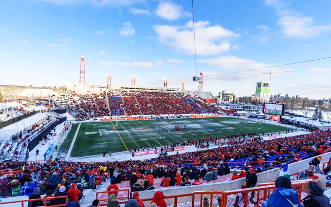
| Victoria Park / Stampede Station | Close to the Stampede grounds, Saddledome, and BMO Centre |
| Erlton / Stampede Station | Near Union Cemetery and the Reader Rock Garden area |
| 39 Avenue Station | Stop in the Manchester industrial area |
| Chinook Station | Near Chinook Centre |
| Heritage Station | Close to Heritage Park, which has a summer shuttle |
| Anderson Station | Access to Southcentre Mall and the CTrain maintenance hub |
| Canyon Meadows Station | Connects toward Lake Bonavista |
| Fish Creek / Lacombe Station | Near Fish Creek Provincial Park and St. Mary’s University |
| Shawnessy Station | Near Shawnessy Shopping Centre |
| Somerset / Bridlewood Station | Southern end of the Red Line |
Other sightseeing ideas in Calgary
- Calgary Zoo
- Heritage Park Historical Village
- The Core Shopping Centre
- Glenbow Museum
- Calgary Tower
- Downtown walks between Calgary Tower and Stephen Avenue
- Prince’s Island Park
- Spruce Meadows
Calgary also hosts major events and festivals such as Stampede, the Calgary Film Festival, and Beerfest, so the CTrain can be a useful route for getting to some of the city’s busiest attractions.
I JUST WANT TO KNOW do the C-trains operate on Sundays???? Cannot find this anywhere and very frustrating