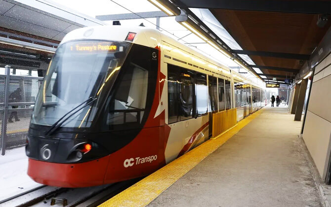
The O-Train is Ottawa’s urban rail system, operated by OC Transpo and built around three fully grade-separated lines: Line 1, Line 2, and Line 4. Line 1 runs east-west through downtown, including a 2.8 km (1.7 mi) tunnel, while Line 2 runs north-south and Line 4 links the airport with South Keys. First launched in 2001 as a pilot project, the system is now a core part of public transport in Ottawa, connecting downtown, Carleton University, the airport, and the wider Transitway network. The network is also in expansion under Stage 2, with more lines, stations, and track planned between 2026 and 2027.
| Key | Information |
|---|---|
| Operator | OC Transpo |
| Current lines | Line 1, Line 2, Line 4 |
| Network type | Urban rail transit system |
| Downtown tunnel | 2.8 km (1.7 mi) on Line 1 |
| Current stations | 25 |
| Airport service | Line 4 connects South Keys and Ottawa Macdonald-Cartier International Airport |
| Started operation | 2001 |
| Expansion | Stage 2 is ongoing, with further openings expected from 2026 to 2027 |
| Planned expanded network | 4 lines, 41 stations, 64.5 km (40.1 mi) of track |
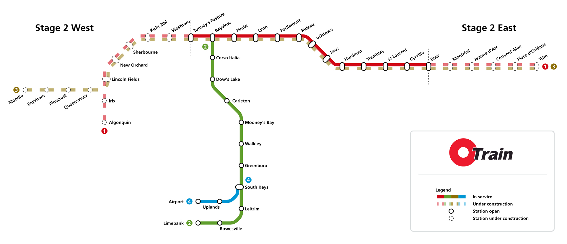
O-Train Ottawa Map
Map of O-Train Ottawa showing different lines. Click on the map to enlarge it or download the O-Train Ottawa map in PDF format.
O-Train Stations
The O-Train stations map currently covers three lines and 25 stations, with more to come as Stage 2 moves forward. Line 1, the Confederation Line, has 13 stations. Line 2, the Trillium Line, has 11 stations. Line 4, the Airport Link, is a 4 km (2.5 mi) branch with 3 stations connecting South Keys and the airport.
Some stations are especially important for transfers. Bayview links Line 1 and Line 2, while South Keys connects Line 2 and Line 4. The system also includes stations with bus links, station parking through park-and-ride locations, and access to major destinations like Carleton University, uOttawa, Rideau Centre, and Ottawa International Airport.
Current stations
| Station | Details |
|---|---|
| Tunney’s Pasture | Line 1 |
| Bayview | Lines 1 and 2 interchange |
| Pimisi | Line 1 |
| Lyon | Line 1 |
| Parliament | Line 1 |
| Rideau | Line 1 |
| uOttawa | Line 1 |
| Lees | Line 1 |
| Hurdman | Line 1 |
| Tremblay | Line 1 |
| St-Laurent | Line 1 |
| Cyrville | Line 1 |
| Blair | Line 1 |
| Dow’s Lake | Line 2 |
| Carleton | Line 2 |
| Mooney’s Bay | Line 2 |
| Greenboro | Line 2 |
| Corso Italia | Line 2 |
| Walkley | Line 2 |
| South Keys | Lines 2 and 4 interchange |
| Uplands | Lines 2 and 4 |
| Leitrim | Line 2 |
| Bowesville | Line 2 |
| Limebank | Line 2 |
| Airport | Line 4 airport station |
Stations under construction
Stage 2 will expand the route and add more stations in the east and west. The Line 1 east extension to Trim is scheduled for 2026. The west extension to Algonquin, along with the new Line 3 to Moodie, is expected in 2027.
The east extension stations are Trim, Place d’Orléans, Convent Glen, Jeanne d’Arc, and Montréal. The west extension stations are Westboro, Kichi Zìbì, Sherbourne, New Orchard, Lincoln Fields, Iris, Algonquin, Queensview, Pinecrest, Bayshore, and Moodie.
Operating Hours
O-Train operating hours, opening hours, and opening times vary by day. The details below apply to Line 1 and give a practical snapshot of the train schedule, timetable, and service timings today for most riders.
| Service detail | Timings |
|---|---|
| Monday to Thursday opening hours | 5:00 am to 1:00 am |
| Friday opening hours | 5:00 am to 2:00 am |
| Saturday opening times | 6:00 am to 2:00 am |
| Sunday working hours | 8:00 am to 11:00 pm |
| Monday to Thursday frequency | Every 5 to 15 minutes |
| Friday frequency | Every 5 to 10 minutes |
| Saturday frequency | Every 9 minutes |
| Sunday frequency | Every 9 to 10 minutes |
| Early morning running time pattern | 5:00 am to 6:30 am: every 8 minutes |
| Morning peak | 6:30 am to 9:00 am: every 5 minutes |
| Mid-day | 9:00 am to 3:00 pm: every 10 minutes |
| Afternoon peak | 3:00 pm to 6:30 pm: every 5 minutes |
| Evening | 6:30 pm to 11:00 pm: every 10 minutes |
| Late night / last train period | 11:00 pm to 1:00 am: every 15 minutes |
If the system is closed, partially closed, or the line does not run during regular hours, select Rapid bus services may be extended through downtown. R1 bus service may also operate instead, serving all Line 1 stations with limited stops.
Because service can change, check the latest schedule today, route timetable, and closing time before you travel, especially late at night or on weekends.
Fares and Prices
OC Transpo offers several ticket and pass options for O-Train travel, including cash, O-Payment, Presto, DayPasses, and monthly passes. Every ride includes a 90-minute minimum transfer window from your first tap or from the time you buy your ticket.
Per-ride fares
| Service detail | Timings |
|---|---|
| Cash fare / ticket price | CAD $4.15 (USD $3.03) |
| O-Payment fare | CAD $4.10 (USD $2.99) |
| Adult fare | CAD $4.10 (USD $2.99) |
| Senior fare (65+) | CAD $3.28 (USD $2.39) |
| Pre-Teen fare (11-12) | CAD $2.05 (USD $1.50) |
| Child fare (10 and under) | Free |
| EquiPass fare | CAD $1.75 (USD $1.28) |
| Community fare | CAD $1.75 (USD $1.28) |
| Para Transpo Rural fare | CAD $11.00 (USD $8.03) |
Discount fares are not available when paying cash. To get reduced fare pricing, riders need a Presto card. Seniors also need a Presto card to ride free on Wednesdays and Sundays.
You can load a card or buy single-ride tickets at a ticket machine using cash, debit, or credit. On buses, exact fare in cash is accepted, and a paper transfer serves as proof of payment. Children 10 and under can get a Child card from the Rideau Centre Customer Service Centre to tap through fare gates.
O-Payment is accepted on all buses and at O-Train Line 1 fare gates for adult fares. Riders can tap an Interac debit card, credit card, Apple Pay, or Google Pay. The same card works for transfers, and within the transfer window you are not charged again. Daily fare is capped at the DayPass price, and monthly cost is capped at the Adult monthly pass price. If you are comparing fare, ticket price, and pass cost, that cap acts a bit like a built-in fare calculator.
DayPasses
| Service detail | Timings |
|---|---|
| 1 day pass price | CAD $12.25 (USD $8.94) |
| 3 day pass price | CAD $30.75 (USD $22.45) |
| 5 day pass price | CAD $49.00 (USD $35.77) |
| 7 day pass price | CAD $58.00 (USD $42.34) |
| 2-for-1 DayPass (weekends and holidays) | CAD $12.25 (USD $8.94) |
Day passes work on OC Transpo, Para Transpo, and STO services from the time of purchase until expiry. On weekends and statutory holidays, one day pass can be used as a 2-for-1 pass for two customers aged 13 or older.
Monthly passes
| Service detail | Timings |
|---|---|
| Adult monthly pass | CAD $138.50 (USD $101.11) |
| Senior monthly pass | CAD $59.75 (USD $43.62) |
| EquiPass monthly pass | CAD $58.25 (USD $42.53) |
| Community monthly pass | CAD $43.25 (USD $31.57) |
| Access monthly pass | CAD $43.25 (USD $31.57) |
Monthly passes are available through Presto and ParaPay. ParaPay cannot be used for trips on OC Transpo buses or the O-Train, and Access pass holders pay a CAD $2.75 (USD $2.01) top-up per ride to use Para Transpo services. Monthly adult fares are also capped through O-Payment.
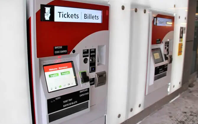
Presto cards can be bought online, at ticket machines, or in person at the OC Transpo Customer Service Centre. Replacement cards cost CAD $4.00 (USD $2.92).
Additional notes
ParaPass is a paperless monthly pass for unlimited Para Transpo trips during the month, at the same price as Presto passes. For Para Transpo Rural Zone trips, the one-way fare between a rural zone and the urban area is CAD $11.00 (USD $8.03), and children 10 and under ride free.
Interconnectivity
The O-Train system is designed to make transfers across Ottawa easier. Line 1 connects with Line 2 at Bayview, and Line 4 connects with Line 2 at South Keys. Those links help tie rail service into the city transport network, along with key bus connections on the Transitway.
Track switches also support the wider transport system. On Line 1, there are seven locations where trains can cross from one track to another. OC Transpo’s control centre manages these movements to support reliable operation.
Some stations are laid out specifically to simplify transfers. South Keys uses an island platform for easier cross-platform movement between airport branch trains and Bayview-bound trains. Bayview is another major interchange, and the connection there sits within a fare-paid zone.
As expansion continues, the route plan becomes more direct. The east extension will run from Blair to Trim, the west extension will take Line 1 to Algonquin and create Line 3 to Moodie, and the south extension to Limebank and Airport is already open. Together, these additions improve transportation in Ottawa by connecting more neighbourhoods and destinations.
The O-Train is powered by 1,500 volts of electricity delivered through the Overhead Catenary System on Line 1, supporting day-to-day operation across the rail network.
Airport Connection
Airport Station is the western terminus of Line 4, also known as the Airport Link, and provides a direct path train connection to Ottawa Macdonald-Cartier International Airport. The elevated station sits near the departure roadway and terminal building, making the airport route straightforward for travelers.
The station is built for an easy transfer between air travel and local transport. Its entrance and lounge extend from the terminal, and the platform lines up with the terminal’s third level.
Fares and navigation
- Ticket machines with video chat help
- Fare gates at the station entrance
- Fare-paid zone for easier connections
- Clear signage and wayfinding
- Illuminated O pylon and lantern box
- Digital departure screens with estimated train and bus timings
- Service maps
- Free OC information phones for trip planning help
Nearby places of interest
| Station | Details |
|---|---|
| Ottawa Airport | Direct access via Airport Station on Line 4 |
| EY Centre | Near the airport connection |
When Line 4 does not run, alternative bus service connects riders between stations, including overnight service after the line closes.
Accessibility
With the O-Train Extension, OC Transpo has renewed its focus on accessible public transport. Accessibility features on trains and at stations are intended to support riders while planning, boarding, traveling, and getting assistance.
- Onboard experience
- At the station
- Wayfinding and orientation
- Trip planning
- Service animals
- Web standards
OC Transpo also runs a Travel training program for people with disabilities and seniors. It helps riders learn how to use buses and the O-Train safely and independently, including trip planning, route numbers, stops, schedules, boarding, exiting, and street safety.
Support is available for riders who are Deaf, hard of hearing, or speech-impaired through the Canada Video Relay Service, which connects users to a sign language interpreter in real time.
Riders who need help using the system can travel with a support person free of charge with an a-card. The a-card is available for clients with a support person, a CNIB card, or an Attorney General of Ontario card. OC Transpo also offers the Community Pass for Ontario Disability Support Program recipients living in Ottawa.
Service animals are allowed on all OC Transpo vehicles. Riders are asked to make sure animals do not block the aisle.
Accessible format support is also available for riders who need help using information or documents in a preferred format.
Tips and Rules
The O-Train is designed to be frequent, easy to use, and safe. If this is your first trip, a few simple rules can make the ride smoother.
Buying your fare
Every station has ticket machines that accept cash, debit, and credit cards. Some also offer live video chat help. You can also tap at the fare gate with a credit card or mobile wallet.
Fare gates accept a Presto card, mobile wallet, or ticket. They are wide enough for mobility devices, strollers, luggage, and families with children. O-Payment also lets you tap a credit card or mobile wallet to begin your trip.
If you use O-Payment, use the same card for transfers to avoid being charged again within the transfer window. Daily fare-capping also applies. O-Payment is not available on STO, so a Presto card is still the better choice for discounts or STO transfers.
Using stations and fare-paid zones
Stations are clearly signed, with wayfinding for platforms, exits, and amenities. Audio and tactile tools are available, and station screens show real-time schedule, route, and service updates.
Once you pass through the fare gate, you are in the fare-paid zone. At major transfer stations, you can move between bus and train services without tapping again.
Boarding and exiting
Wait behind the yellow line until the train stops fully. Let passengers get off before you board. When exiting, step out carefully and mind the gap.
Safety and etiquette
- Stay behind the yellow line until the train has stopped completely.
- Never step on the track, even if you drop something.
- Pay attention to signs and audio announcements.
- Do not rush to catch a train or bus.
- Be considerate of other riders, keep noise down, and dispose of trash properly.
- Offer your seat to anyone who needs it more.
- Use station emergency phones to contact the Special Constable Unit if needed.
Service hours and direction
Service hours vary by line and day. Line 1 runs from early morning until after midnight on weekdays, with later service on Friday and Saturday. Line 2 and Line 4 also run daily, with different timings depending on the day.
To confirm direction, look for the terminal station shown after the line number. For example, Line 2 runs toward Bayview or Limebank, and Line 4 runs toward South Keys or Airport. Future route signage will also include Line 1 to Algonquin or Trim and Line 3 to Moodie or Trim.
Extra help
If you need assistance, customer service can help with tickets, transfers, and using the system. A quick check of the stations map, schedule today, and route before you leave usually saves time.
Interesting Facts
The O-Train began in 2001 as Ottawa’s first light rail project and started as a pilot to test whether an existing rail corridor could support rapid transit. The original route was 8 km (5.0 mi) long, passed five stations, and linked with the city’s bus rapid transit network at both ends.
It crossed two bridges and ran through a tunnel beneath Dow’s Lake, serving Carleton University, a major employment centre, and a busy shopping area.
The pilot stood out for several North American firsts. It mixed light rail passenger trains with heavy rail traffic on an existing corridor, used Bombardier Talent DMU trains in North America, and relied on bus operators to drive the trains.
Early results were strong: daily ridership topped 9,000, more than 3,000 car trips were removed per day, and on-time performance reached 99%, compared with 70% for the overall transit system.
- Capital cost: CAD $21 million (USD $15.33 million)
- Two-year operating cost: CAD $8 million (USD $5.84 million)
- Annual revenues: CAD $1.6 million (USD $1.17 million)
- Revenue/cost ratio: 36%
The original line was designed to be accessible for wheelchair users and cyclists, and it helped shape later rail expansion plans across the city.
History
Pilot project
The O-Train launched in 2001 as a pilot project offering an alternative to Ottawa’s busways. The original north-south line, now Line 2, was 8 km (5.0 mi) long, single-tracked, and built for CAD $21 million (USD $15.33 million). The project included three low-floor Bombardier Talent diesel multiple unit trains and kept costs down by reusing a Canadian Pacific Railway freight corridor and using simple station construction.
Name
The name O-Train was proposed by Acart Communications, an Ottawa advertising agency. It was inspired by “Take the ‘A’ Train” and was chosen to work in both English and French. From launch until 2014, the name referred only to the north-south diesel line. When the Confederation Line opened, O-Train became the name for both rail services, and the original line became the Trillium Line.
Early extension plans
In 2006, Ottawa City Council approved a north-south expansion plan that would have replaced the Trillium Line with a double-track electric light rail system. The proposal included an eastward extension through LeBreton Flats and downtown to the University of Ottawa, plus a southwest extension to Riverside South and Barrhaven. A possible link from the University of Ottawa terminus to Hurdman was also considered.
Expansion controversies and cancellation
The project became a major issue in the 2006 municipal election. After the new council took office on December 1, 2006, it debated several options, including continuing, reducing, or cancelling the project. A first vote supported moving ahead without the downtown section, but a later vote on December 14 cancelled the contract by 13-11 after funding deadlines were missed. The cancelled project was later reported to have cost about CAD $73 million (USD $53.29 million).
New transit plans
After the cancellation, the city kept planning for rail growth. A 2007 committee recommended a broader light rail network with rail rights-of-way, new stations, and a downtown tunnel. In late 2007 and early 2008, the city advanced new options that included the tunnel and suburban rail expansion. Council approved a preferred plan in 2008, with future extensions depending on population growth and funding.
Confederation Line
On December 19, 2012, city council unanimously approved the Confederation Line, an east-west light rail line from Blair to Tunney’s Pasture. Construction started in 2013, and the line opened on September 14, 2019. Most of the route uses former Transitway infrastructure, apart from the downtown tunnel.
Stage 2
Stage 2 is the current expansion project for the O-Train system. First approved in 2013 and built in phases from 2019, it adds 44 km (27.3 mi) of rail and 24 new stations. The project covers east, west, and south extensions, plus the airport shuttle connection. Completion is expected by 2027, with openings staged between 2025 and 2027.
In March 2019, Ottawa City Council approved the contracts to begin construction. The Trillium Line southern extension went to TransitNext, while the east and west extensions of the Confederation Line went to East West Connectors. The Trillium Line reopened on January 6, 2025, after closing for Stage 2 upgrades.
Future Expansions
The O-Train expansion adds more than 44 km (27.3 mi) of rail, more than 24 new stations, and more than 45 new trains to Ottawa’s transport network. The aim is a larger system with better connections across the city.
What is already open
The South Extension to Limebank and Airport stations is already open Monday through Sunday, improving connections on Lines 2 and 4.
What is coming next
- Line 1 East Extension: Line 1 will continue from Blair through Orléans to Trim, adding five new east stations and more than 1,000 new park-and-ride spaces at Trim, Place d’Orléans, and Jeanne d’Arc.
- Lines 1 and 3 West Extension: Line 1 will expand west to Algonquin Station, while the new Line 3 will serve Moodie Station.
- System growth: the larger network is intended to simplify trips, improve direct travel, and strengthen links to neighbourhoods, destinations, and the airport.
Station and city benefits
Across the project, 24 new and updated stations are planned to improve access across Ottawa. The wider transport plan also aims to reduce congestion, lower the city’s carbon footprint, and improve walking and cycling links to transit.
Stage 2 is expected to be fully complete by 2027, with the east extension targeted for 2026 and the west extension for 2027.
Tourist Attractions

The O-Train gives visitors a practical way to get around Ottawa and reach many of the city’s best-known attractions. Depending on the route and stations you use, it connects downtown landmarks, shopping areas, cultural sites, parks, universities, and the airport.
Key destinations along the system include CF Rideau Centre, ByWard Market, Parliament area attractions such as the National Arts Centre, the Rideau Canal, the National Gallery of Canada, and the Senate of Canada Building, along with South Keys Shopping Centre, St. Laurent Shopping Mall, and Place d’Orléans Shopping Centre.
Rideau Station is one of the most useful stops for sightseeing, with easy access to CF Rideau Centre and the ByWard Market area. uOttawa serves the university district and nearby downtown sights. Bayview is a key transfer station, while South Keys connects travelers to Line 4 for airport trips.
You can also use the system to reach Carleton University, Algonquin College, Dow’s Lake, Mooney’s Bay, LeBreton Flats, Little Italy, Vincent Massey Park, and the EY Centre. For visitors flying in or out, the airport connection makes the trip simpler with fewer transfers.
In winter, the O-Train is designed to keep running in cold weather, so it remains a useful city transport option year-round.