The Toronto Subway and RT is Toronto’s rapid transit system, operated by the Toronto Transit Commission. It began in 1954 with Canada’s first completed subway line under Yonge Street and now forms a core part of public transport in Toronto and Vaughan. The network includes underground, elevated, and light rail routes; the former Scarborough RT, later Line 3 Scarborough, closed permanently in 2023.
| Key | Information |
|---|---|
| Operator | Toronto Transit Commission |
| Opened | 1954, with the original Yonge subway |
| System type | Rapid transit, including subway and light rail lines |
| Network size | As of 2026, 109 stations and 99.4 kilometers of route, about 61.8 miles |
| Main role | A major city transport system for daily commuting, local transport, airport connections, and regional transfers |
| Typical working hours | Subway service generally runs from early morning until about 1:30 a.m., with later starting time on Sundays and holidays |
Toronto Subway and RT Map
Map of Toronto Subway showing different lines and stations. Click on the map to enlarge it or download the Toronto Subway map in PDF format.

Toronto Subway and RT Lines and Stations
The Toronto Subway and RT network includes five operating rapid transit lines in Toronto and Vaughan, plus the Ontario Line under construction. Line 1 Yonge–University is the longest and busiest route, Line 2 Bloor–Danforth runs east–west, Line 4 Sheppard serves North York, and Lines 5 Eglinton and 6 Finch West extend the system with light rail service. If you are planning a trip, the stations map and stations list are the easiest way to understand the route plan before you travel.
| Station | Details |
|---|---|
| Line 1 Yonge–University | Vaughan Metropolitan Centre, Highway 407, Pioneer Village, York University, Finch West, Downsview Park, Sheppard West, Wilson, Yorkdale, Lawrence West, Glencairn, Eglinton, St. Clair West, Dupont, Spadina, St. George, Museum, Queen’s Park, St. Patrick, Osgoode, St. Andrew, Union, King, Queen, Dundas, College, Wellesley, Bloor–Yonge, Rosedale, Summerhill, St. Clair, Davisville, Eglinton, Lawrence, York Mills, Sheppard–Yonge, North York Centre, Finch |
| Line 2 Bloor–Danforth | Kipling, Islington, Royal York, Old Mill, Jane, Runnymede, High Park, Keele, Dundas West, Lansdowne, Dufferin, Ossington, Christie, Bathurst, Spadina, St. George, Bay, Bloor–Yonge, Sherbourne, Castle Frank, Broadview, Chester, Pape, Donlands, Greenwood, Coxwell, Woodbine, Main Street, Victoria Park, Warden, Kennedy |
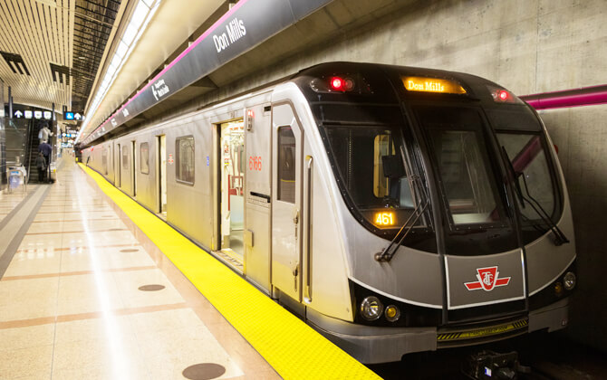
| Line 4 Sheppard | Sheppard–Yonge, Bayview, Bessarion, Leslie, Don Mills |
| Line 5 Eglinton | A 19-kilometer route, about 11.8 miles, from Kennedy to Mount Dennis with 25 stopping points, including 15 underground stations and 10 at-grade stops. Named stops include Kennedy, Lawrence, and Mount Pleasant |
| Line 6 Finch West | A surface light rail route from Finch West to Humber College with 18 stops |
| Former Line 3 Scarborough | The Scarborough RT opened in 1985 between Kennedy and McCowan via Scarborough Centre and closed permanently in 2023 |
| Ontario Line | Under construction, with 15 stations planned from Exhibition to Don Valley |
Most stations outside the downtown core connect with TTC bus or streetcar routes inside the fare-paid area. Trains normally stop at every station on their line, except during short turns, and usually run the full route from terminus to terminus.
Many station names come from nearby arterial roads, while others reflect landmarks, institutions, and major transfer points. On Line 1, for example, Museum, Queen’s Park, Osgoode, St. Patrick, and St. Andrew are named for nearby landmarks and institutions.
Accessibility has improved steadily through elevators, wide fare gates, and access doors. As of 2026, College, Islington, King, Lawrence, Museum, Old Mill, and Spadina are not fully accessible.
Schedules and Frequency
The TTC subway is not a 24-hour system, so checking the train schedule matters if you are traveling early, late, or on a holiday. For timings today or schedule today, always allow for service changes, especially during construction or planned closures.
| Service detail | Timings |
|---|---|
| Subway operating hours, Monday to Saturday | 6:00 a.m. to 1:30 a.m. |
| Subway operating hours, Sundays and holidays | 8:00 a.m. to 1:30 a.m. |
| December 25 and January 1 starting time | 9:00 a.m. |
| Station opening hours, Monday to Friday | 5:45 a.m. to 2:40 a.m. |
| Station opening hours, Saturdays and holidays | 5:35 a.m. to 2:25 a.m. |
| Station opening hours, Sundays | 7:45 a.m. to 2:30 a.m. |
| Rush-hour frequency | Every 2–3 minutes |
| Off-peak frequency | Every 4–5 minutes |
| Overnight transport | Blue Night Network service runs from about 1:30 a.m. until subway service starts, every 30 minutes or better |
Service may be reduced near closing time and on Sundays. The last train can vary by station and direction, so check the route timetable if your trip is close to the end of service.
Blue Night Network routes use white and blue route lozenges and 300-series route numbers. They are useful when the subway is closed but you still need public transport across the city.
Fares, Tickets, and Passes
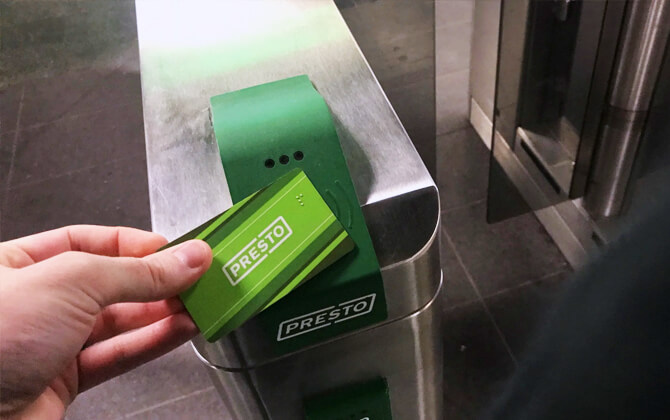
You can pay TTC fare with Presto fare media, contactless credit or debit card, or cash. Presto includes reusable cards, single-use tickets, and open payment. For most trips, you do not need a fare calculator; the ticket price is listed by rider category and payment method.
When you tap a Presto card, Presto ticket, credit card, or debit card, the TTC records your fare and, for most single-ride payments, gives you a two-hour transfer from the first tap. Cash fares are accepted, but cash-paying customers do not receive the two-hour transfer.
| Fare type | Adult | Youth 13–19 | Senior 65+ | Child 12 and under | Fair Pass |
|---|---|---|---|---|---|
| Cash fare | C$3.35, about US$2.61 | C$2.40, about US$1.87 | C$2.30, about US$1.79 | Free | C$3.35, about US$2.61 |
| Presto card | C$3.30, about US$2.57 | C$2.35, about US$1.83 | C$2.25, about US$1.76 | Free | C$2.10, about US$1.64 |
| Credit or debit card | C$3.30, about US$2.57 | C$3.30, about US$2.57 | C$3.30, about US$2.57 | Free | C$3.30, about US$2.57 |
Presto tickets are accepted at TTC subway stations and on surface routes within Toronto, with limited exceptions for certain airport and boundary-area services. The 1-ride and 2-ride tickets include the same two-hour transfer window as Presto cards and contactless payments.
| Fare type | 1-ride | 2-ride | Day pass |
|---|---|---|---|
| Presto tickets | C$3.35, about US$2.61 | C$6.70, about US$5.23 | C$13.50, about US$10.53 |
TTC monthly passes are available only on the Presto card. Adult, youth, senior, post-secondary student, and Fair Pass options are offered, with 12-month pricing available for some categories.
| Passenger type | Monthly pass | 12-month pass |
|---|---|---|
| Adult | C$156.00, about US$121.68 | C$143.00, about US$111.54 |
| Post-secondary student | C$128.15, about US$99.96 | — |
| Senior and youth | C$128.15, about US$99.96 | C$117.45, about US$91.61 |
| Fair Pass | C$123.25, about US$96.14 | — |
Monthly passes provide unlimited travel for the selected month. They can be loaded onto a Presto card during the last 12 days of the previous month and the first 8 days of the new month. Adult, youth, senior, and Fair Pass monthly passes, along with youth and senior 12-month passes, are scheduled to be discontinued on August 31, 2026.
Children aged 12 and under travel free. Youth fares apply to riders aged 13 to 19, and senior fares apply to riders aged 65 and over; both groups may be asked to show ID. The Fair Pass program is available to eligible low-income Toronto residents who receive support through ODSP, Ontario Works, or a Toronto Child Care Fee Subsidy.
- Tap a Presto card, Presto ticket, credit card, or debit card on the reader when boarding or entering a subway station.
- Use cash at a farebox on buses or at staffed subway station entrances.
- Use Presto readers on buses, streetcars, and subway entrances to validate payment and transfers.
- For trips crossing municipal boundaries, a second tap may be required when leaving the vehicle to validate the transfer.
Interchanges
The Toronto Subway and RT system has several important interchange points where riders transfer between subway lines or connect with other transport services. Major stations include Union, St. George, Bloor–Yonge, and Kennedy, while many suburban stations link directly with TTC bus and streetcar routes.
Line 1 connects with Line 4 at Sheppard–Yonge and with Line 2 at St. George. Line 2 connects with GO Transit at stations such as Kipling, Dundas West, Main Street, and Kennedy. Line 4 connects with Line 1 at Sheppard–Yonge and with GO Transit at Leslie. Line 6 connects with Line 1 at Finch West and serves Humber College at its western end.
Some stations also link to regional and intercity services, including GO Transit, VIA Rail, Amtrak, Ontario Northland, and local transit systems such as York Region Transit and Viva.
Inter-line Connections
Transfers between TTC lines are free as long as you stay inside the station’s paid area. These connections are central to the route plan and help riders choose the fastest train path across the city.
- Lines 1 and 2 connect at Spadina, St. George, and Bloor–Yonge.
- Lines 1 and 4 connect at Sheppard–Yonge.
- Line 2 formerly connected with Line 3 Scarborough at Kennedy before Line 3 closed in 2023.
- Lines 2 and 4 do not connect directly.
Connections with Other Systems
The TTC is integrated with Toronto’s bus and streetcar network, including routes that function much like trams in a modern urban tramway. Transfers between TTC services are free when they remain part of the same paid trip.
GO Transit connects with the TTC at several stations and hubs, including Union Station, Kipling, Dundas West, Main Street, Leslie, and Kennedy. Union Station also links the subway with VIA Rail, Amtrak, Ontario Northland, and other intercity services.
Since February 26, 2024, the One Fare Program has allowed free or discounted transfers between the TTC and other Greater Toronto Area transit systems when paying with Presto, credit, or debit card. Cash payments are not eligible and still require a double fare.
The former Scarborough RT did not have direct track connections to the other lines. Vehicles needing major servicing were transported by truck to the Greenwood subway yards.
Airport Connections
Toronto has two major airports: Toronto Pearson International Airport and Billy Bishop Toronto City Airport. The subway does not run directly to either airport, but both can be reached by combining subway, bus, streetcar, rail, or ferry service.
Directions to Toronto Pearson International Airport
Toronto Pearson International Airport is in Mississauga, about 20 kilometers northwest of downtown Toronto, or about 12.4 miles. A small part of the airfield extends into Etobicoke. For transportation in Toronto, it is the main airport serving the city and surrounding region.
The Union Pearson Express is the most convenient rail option between Pearson Airport and Union Station. It departs every 15 minutes from Terminal 1 station and has a running time of about 28 minutes to Union Station.
TTC airport bus options include the 900 Airport Express from Kipling Station on Line 2, the 52 Lawrence West, 352 Lawrence West Night, and 952 Lawrence West Express along Line 1 stations, and route 906 connecting Viscount station with Line 6 Finch West at Humber College station. Older TTC airport route information also lists the 192 Airport Rocket from Kipling Station, with a travel time of about 20 to 25 minutes.
- From Line 2: travel to Kipling Station, then connect to an airport bus toward Pearson.
- From Line 1: connect with Lawrence West services serving the airport corridor.
- Overnight: the 300A Bloor–Danforth route has been used for airport travel between 2:00 a.m. and 5:00 a.m., with about 45 minutes to the airport.
Brampton Transit, MiWay, and GO Transit also serve Pearson. GO Transit operates 24-hour bus routes from Terminal 1, while MiWay and Brampton Transit connect the airport with Mississauga and Brampton.
If you travel by car, Pearson is accessible from Highway 427 and Highway 409, with local access from Airport Road and Dixon Road. Parking garages are located next to Terminals 1 and 3. Taxis, limousines, and rideshare services use designated pickup areas outside both terminals, and the Terminal Link connects Terminal 1, Terminal 3, and Viscount station.
Directions to Billy Bishop Airport
Billy Bishop Toronto City Airport is easiest to reach from the subway by transferring to streetcar or ferry service. From Union Station on Line 1, transfer to the 509 Harbourfront streetcar. From Bathurst Station on Line 2, transfer to the 511 Bathurst streetcar.
| Station | Details |
|---|---|
| Bathurst Street Ferry Terminal | Closest ferry access, about a 6-minute walk |
| Queens Quay West at Bathurst Street East Side Billy Bishop Airport | Streetcar access, about a 9-minute walk |
| Fort York Boulevard at Fleet Street | Nearby bus and streetcar area, about a 9-minute walk |
| Fleet Street at Fort York Boulevard | Nearby stop, about a 9-minute walk |
| Bathurst Street at Fort York Boulevard | Nearby stop, about a 14-minute walk |
Bus routes listed near the airport include 114, 63, 63A, 307, and 307S. Streetcar connections include 509 and 510B, and the airport is also reachable using ferry service. Transfers between TTC services are free within the paid trip, so the journey can often be made with a single ticket across subway, bus, and streetcar.
Guidelines, Notifications, and Recommendations
Before you travel, check TTC service advisories for route diversions, construction, accessibility updates, planned closures, and schedule changes. This is especially helpful if you need the latest timings today or want to know whether a station will close early for work.
- Service Changes: planned short- and long-term service and schedule changes, including reduced speed zones in the subway system.
- Subway and LRT Service: planned subway and light rail closures across the system.
- Streetcar Service Changes: streetcar routes affected by diversions or temporary changes.
- Construction Notices: ongoing projects that may affect your journey.
- Service Alerts: real-time notices for short-term disruptions.
The TTC notifies customers through media releases, Transit Reporter broadcasts, video screens in stations, website postings, social media, email alerts, and trip-planning updates for Wheel-Trans customers. Service information is also shared through station screens and customer support tools.
If your trip may be affected, check before leaving, allow extra travel time, and review alternate options. During planned closures, the TTC may use accessible shuttle buses, scheduled construction buses, signal priority measures, station staffing, and Wheel-Trans support to help keep travel safe and manageable.
Park & Ride Facilities
The TTC provides station parking at 17 subway stations. Parking charges vary by station and time of day. In general, parking is charged from 5:00 a.m. to 2:00 a.m., Monday to Friday, while some stations offer free parking on weekends and public holidays.
Typical parking charges include C$2.00, about US$1.56, between 3:00 p.m. and 2:00 a.m., and C$7.00, about US$5.48, per day. All-day parking from 5:00 a.m. to 2:00 a.m. is not permitted. Payment methods include cash, Visa, Mastercard, and American Express, and some stations use a Mobile Pay app for online reservations and payment.
| Station | Details |
|---|---|
| Don Mills | Park & Ride facility available |
| Ellesmere | Park & Ride facility available |
| Finch | Park & Ride facility available |
| Finch West | Park & Ride facility available |
| Highway 407 | Park & Ride facility available |
| Islington | Park & Ride facility available |
| Keele | Park & Ride facility available |
| Kennedy | Park & Ride facility available |
| Kipling | Park & Ride facility available |
| Lawrence East | Park & Ride facility available |
| Leslie | Park & Ride facility available |
| Pioneer Village | Park & Ride facility available |
| Sheppard West | Park & Ride facility available |
| Victoria Park | Park & Ride facility available |
| Warden | Park & Ride facility available |
| Wilson | Park & Ride facility available |
| Yorkdale | Park & Ride facility available |
Nearly all subway stations have bike parking on-site or nearby, including post-and-ring spaces and multi-bicycle racks. There is capacity for more than 2,500 bicycles at or near station entrances on TTC and City property.
The City of Toronto also operates secure bike lockers and bike parking stations at selected locations. Bicycle lockers are available at Bayview, Don Mills, Sheppard West, Yorkdale, Finch, Kennedy, and Kipling stations. Secure indoor bike parking stations are available at Finch West, Union, and Victoria Park.
Interesting Facts
The Toronto Subway and RT opened in 1954 with Canada’s first underground rail line, the original Yonge subway. As of 2026, it has grown into a 109-station network covering 99.4 kilometers, or about 61.8 miles, of route.
Line 1 Yonge–University began as a 7.4-kilometer route, about 4.6 miles, and expanded into a 38.8-kilometer U-shaped line, about 24.1 miles, with terminals at Finch and Vaughan Metropolitan Centre.
The heavy-rail subway uses the unique Toronto gauge and is powered by 600 V DC third rail. The Scarborough RT used different technology and standard-gauge track, which made it incompatible with the rest of the system.
The Bloor–Danforth subway was helped by early planning on the Prince Edward Viaduct, which was built with space below the roadway for future rail traffic. That decision later allowed the subway to cross the Don Valley.
The system has also faced major challenges, including the 1995 Russell Hill accident and the 2023 closure of Line 3 Scarborough after a derailment. The Ontario Line and several extensions are now under construction.
History
Toronto’s rapid transit history began with early proposals in the first decades of the 20th century, when planners suggested burying the Yonge streetcar line. Several ideas were discussed between 1909 and 1912, but a 1912 plebiscite rejected subways. In 1931, City Controller Hacker proposed a north–south subway route from Avenue Road and St. Clair to Front and York Streets.
During World War II, heavy travel demand on Yonge Street pushed the TTC to study rapid transit more seriously. Between 1942 and 1946, the TTC’s Rapid Transit Department developed a cut-and-cover plan from Eglinton Avenue to Front Street and Union Station. Voters approved the project on January 1, 1946, and construction began on September 8, 1949.
Toronto’s first subway opened on March 30, 1954. The original Yonge subway ran 7.4 kilometers, about 4.6 miles, from Eglinton to Union and became Canada’s first subway. It was quickly busier than expected, leading to regular use of longer trains.
Expansion continued in stages. The University extension opened in 1963, the Bloor–Danforth subway opened in 1966, the Yonge line reached Finch in 1974, the Spadina extension opened in 1978, the Scarborough RT opened in 1985, North York Centre opened in 1987, another Spadina extension followed in 1996, and the Sheppard subway opened in 2002.
On August 11, 1995, the Russell Hill accident became the deadliest subway accident in Canadian history. Three people died and 100 were injured, leading to a stronger focus on safety and system maintenance. In 2023, Line 3 Scarborough closed after a derailment and was later permanently decommissioned.
More recent changes include the Line 1 extension to Vaughan Metropolitan Centre in 2017, Line 6 Finch West opening in 2025, and Line 5 Eglinton opening in 2026 after years of delay. The network continues to evolve through the Ontario Line and extensions to existing routes.
Planned Developments
The TTC and City of Toronto are working on several projects to improve the customer experience, station safety, accessibility, and transit expansion across the network. Current efforts include Easier Access work, second exit and entrance projects, major service planning, and new rapid transit routes.
- Transit expansion projects are in planning, design, and construction, with the goal of improving mobility across Toronto.
- The 5-Year Service Plan and Customer Experience Action Plan covers public transport improvements between 2024 and 2028.
- RapidTO explores priority bus-only lanes and other service measures on some of the busiest corridors.
- The former Line 3 Scarborough was a 6.4-kilometer line, about 4.0 miles, with six stations. Interim bus service is planned until the Scarborough Subway Extension opens in 2030.
- Second exits and entrances are being added at selected stations to improve customer safety and convenience.
- Spadina Station is set for upgrades to improve accessibility, the customer experience, and streetcar reliability.
- Light rail remains part of the broader expansion strategy, with longer-term reviews of additional network growth.
Sights to See Along the Subway
Toronto’s subway, streetcar, and commuter rail corridors are closely tied to the cityscape. Many of the best views sit near major stations, where historic neighborhoods, waterfront routes, and dense downtown streets meet.
Union Station is the main starting point for many visitors. It sits near Lake Ontario and serves GO Transit, VIA Rail, the subway, and the Union Pearson Express. Nearby skywalks give views over the platforms, while the Spadina Bridge and Bathurst Bridge overlook the rail corridor. For the most famous panorama, the CN Tower observation deck looks across downtown and the tracks below.
Behind Union Station, the waterfront is a short walk away. The Queens Quay streetcar line emerges from the Union tunnel and runs in dedicated lanes beside the lake. At the foot of Bay Street, ferries depart for the Toronto Islands, where skyline views are wide and easy to enjoy.
The streetcar network is one of Toronto’s defining transit features. Parkdale shows how older commercial streets grew around streetcar service, while the Broadview corridor brings several routes together near Riverdale Park. King Street is another useful place to watch streetcars moving through a transit-priority corridor.
For subway scenery, Museum Station is known for its redesigned platform beneath the Royal Ontario Museum. St. George and Bloor–Yonge are major transfer points, while Bayview, Sheppard West, Downsview, and Ossington are noted for public art.
Rail fans may like Bloor Station and the nearby pedestrian bridge for views of GO Transit, the UP Express, and occasional VIA Rail trains. Farther west, Long Branch Station and Mimico are also useful places to watch GO trains along the lakeshore.