The MBTA Subway is the core rapid transit system for Boston and nearby communities, operated by the Massachusetts Bay Transportation Authority. It includes heavy rail, light rail, and bus rapid transit services shown together on the MBTA stations map: the Red, Orange, Blue, Green, Mattapan, and Silver lines. The system connects central Boston with surrounding neighborhoods and suburbs through major downtown transfer stations, and it is also known for its history: the Tremont Street subway segment, now part of the Green Line, opened in 1897 and remains the oldest transit subway in North America still in use.
| Key | Information |
|---|---|
| System | MBTA rapid transit system in the Boston metropolitan area |
| Common names | The subway, the T system, or simply the T |
| Lines shown on the map | Red, Orange, Blue, Green, Mattapan, and Silver |
| Network pattern | Spoke-hub layout centered on downtown transfer stations |
| Total stations | 153 stations and stops |
| Underground stations | 31 |
| Historic milestone | Tremont Street subway opened in 1897 |
| Coverage | Links central Boston with nearby neighborhoods and suburbs |
MBTA Subway Map
Map of MBTA Subway System in Boston showing different lines and stations. Click on the map to enlarge it or download the MBTA Subway System map in PDF format.
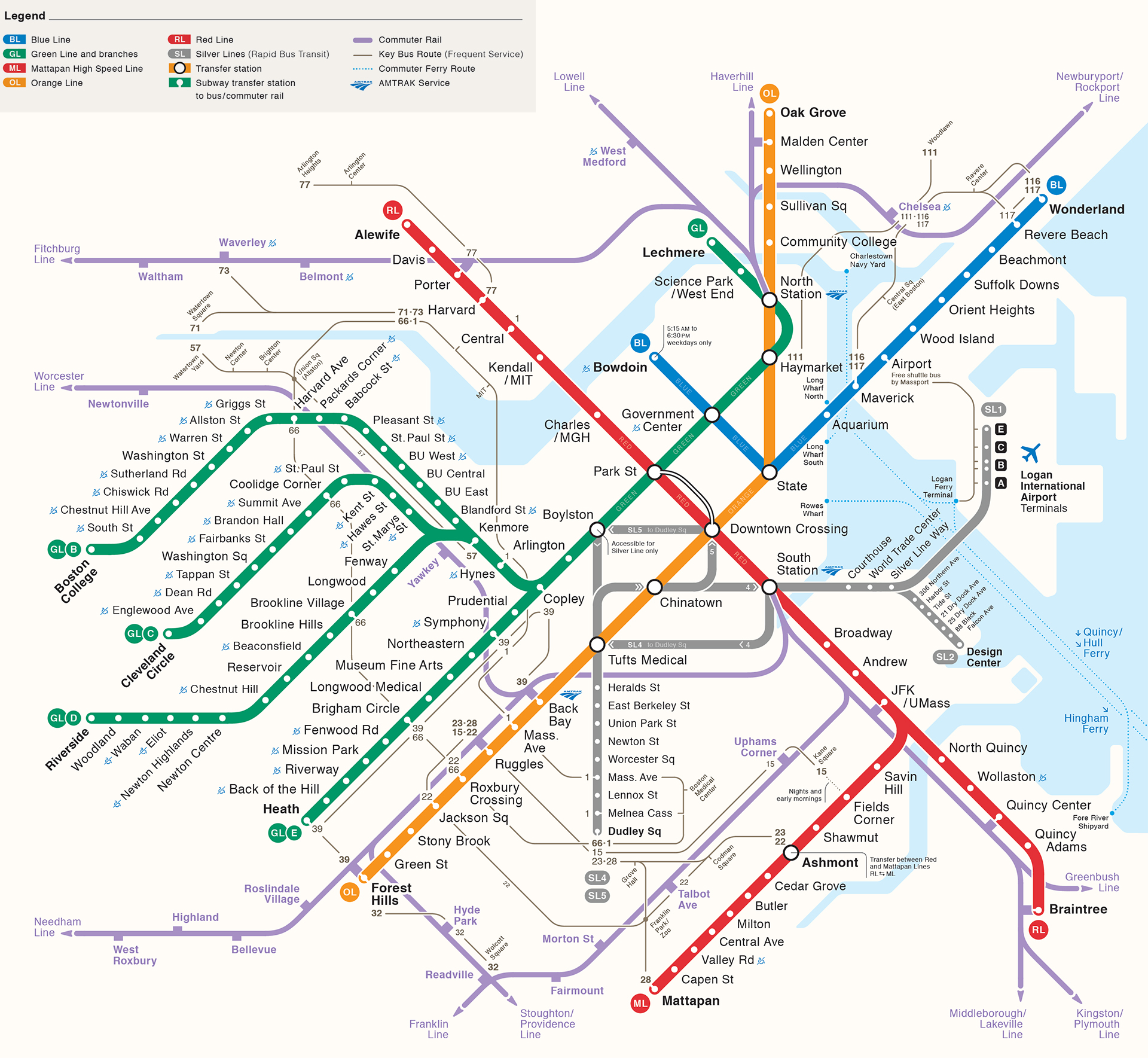
MBTA Subway Lines and Stations
The MBTA subway system combines rapid transit, light rail, and bus rapid transit across Boston and nearby municipalities. As of December 2022, it has 153 open stops and stations served by the Green, Blue, Red, Orange, and Silver lines.
Station types vary quite a bit. Some are simple marked stops on the Green and Silver lines, while others are large underground transfer complexes downtown. Most stations are named after nearby streets, squares, neighborhoods, or institutions, including Park Street, Central, Chinatown, and Airport.
The route plan is organized by line and branch. The Green Line has B, C, D, and E branches, the Red Line splits south to Ashmont and Braintree, and the Silver Line appears on the subway map even though it is bus rapid transit. Downtown hub stations are Park Street, State, Government Center, and Downtown Crossing, with inbound trains heading toward these transfer points and outbound trains heading away from them.
South Station is the busiest MBTA subway station, with average weekday boardings above 24,000 in 2019. Park Street is a major transfer station for the Green and Red lines, and JFK/UMass is an important link between the subway and Commuter Rail. Current materials also mention a proposed Silver Line infill station at Day Square and a proposed but unfunded Green Line station at Mystic Valley Parkway.
| Station | Details |
|---|---|
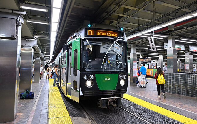
| Green Line | B, C, D, E branches; light rail; 70 stations |
| Orange Line | Oak Grove ↔ Forest Hills; heavy rail; 20 stations |
| Blue Line | Wonderland ↔ Bowdoin; heavy rail; 12 stations |
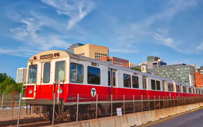
| Red Line | Alewife ↔ Ashmont and Alewife ↔ Braintree; heavy rail; 22 stations |
| Mattapan Line | Ashmont ↔ Mattapan; light rail; 8 stations |
| Silver Line | SL1, SL2, SL3, SL4, SL5, SLW; bus rapid transit; 34 stations |
| Total | All lines combined; rapid transit system; 153 stations |
- All stations in this stations list are currently open and operated by the MBTA.
- The system includes underground stations, surface stops, and marked stop-style stations depending on the line and location.
- The Silver Line includes underground branches with subway fare and surface branches with lower bus fare.
Timings, Frequency and Schedule
MBTA Subway operating hours generally start around 5:00 AM to 6:00 AM, depending on the line and day, and continue until about 1:00 AM the next day. On weekdays and Saturdays, the usual starting time is around 5:00 AM. On Sundays, opening times are typically later, around 6:00 AM, while the closing time stays near 1:00 AM.
If you are checking timings today or schedule today for a specific route, it is smart to verify the latest train schedule before you travel. The first train, last train, and exact working hours can vary by station and line.
Frequency changes by line, time of day, and day of week. During weekday rush hours, trains may arrive every 5 to 10 minutes. Late at night, service is less frequent, and on Sundays late-night timings can range from every 8 to 26 minutes. Weekend service is usually less frequent than weekday peak service.
Real-time timetable updates, route timetable changes, delays, and station alerts are available in the app and online. For the most accurate schedule, especially if you need the running time for a particular route or want to know when service may close, check your station before heading out.
| Service detail | Timings |
|---|---|
| Weekday opening hours | Usually around 5:00 AM |
| Saturday opening hours | Usually around 5:00 AM |
| Sunday opening times | Typically around 6:00 AM |
| Last train / closing time | About 1:00 AM |
| Weekday peak frequency | About every 5 to 10 minutes |
| Sunday late-night frequency | About every 8 to 26 minutes |
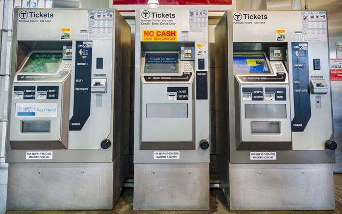
MBTA Subway Fares, Tickets and Cards
The MBTA offers fare options for the subway, bus, Commuter Rail, and ferry. Transfer rules depend on the ticket, pass, or card you use. Reduced fare options are available for eligible riders, and children age 11 and under ride free.
Standard One-Way Fares
| Subway One-Way | $2.40 USD with CharlieCard, CharlieTicket, contactless payment, or cash |
| Reduced Fare One-Way | $1.10 USD with a reduced fare card |
These ticket prices apply on the Red, Orange, Green, and Blue lines, the Mattapan Trolley, and Silver Line routes SL1, SL2, and SL3.
Transfers
For Local Bus, Express Bus, Silver Line, and Subway, you can transfer up to two times and pay only the cost of the highest-priced service.
Certain monthly Commuter Rail passes printed on a CharlieTicket include unlimited transfers to any mode. Single-ride Commuter Rail and ferry tickets generally do not include free transfers.
Transfers are not available with stored-value CharlieTickets or cash payments. Transfer rules still apply when using contactless payment.
Passes
Day pass and weekly pass validity depends on where the pass is loaded. A 1-day or 7-day pass on a CharlieTicket is valid from the date and time of purchase. The same pass on a CharlieCard becomes valid from the first tap into a subway station. Monthly passes can be bought at fare vending machines starting on the 15th of the previous month, or through Auto-pay.
| 1-Day Pass | $11.00 USD for unlimited travel for 24 hours |
| 7-Day Pass | $22.50 USD for unlimited travel for 7 days |
| Monthly LinkPass | $90.00 USD for unlimited travel for the remainder of the month |
| Monthly Local Bus Pass | $55.00 USD for unlimited travel for the remainder of the month |
CharlieCard and CharlieTicket passes are valid on the subway, local bus, and Silver Line. Depending on the pass type, CharlieTicket passes may also be valid on Commuter Rail Zone 1A and selected ferry services. Monthly LinkPasses are not valid on Express buses.
Cards and Payment Options
| CharlieCard | Best for regular bus and subway riders; valid on subway, bus, and Silver Line |
| CharlieTicket | Best for visitors, Commuter Rail, and ferry riders; available at any subway station |
| Contactless payment | Best for visitors and regular riders; valid on subway, bus, Silver Line, and Mattapan Line |
| mTicket | Best for Commuter Rail and ferry riders; supports online purchase and ticket scan |
You can also pay cash on buses and at street-level trolley stops. EBT cards can be used to load value or passes onto a CharlieCard or CharlieTicket at fare vending machines, the Charlie Service Center, or MBTA retail sales locations that accept EBT.
Reduced Fares
Reduced fares are available for people age 65 and older, people with disabilities, middle and high school students, and low-income adults. Some riders, including people who are blind or have low vision and children 11 and under, travel free.
Connections to Other Systems
The MBTA subway is closely tied to other public transport services in Boston, especially the bus network and Commuter Rail. Major transfer points with regional rail include South Station, North Station, and Back Bay, while other commuter rail stations also connect with the subway and make city transport and local transport trips easier to plan.
The Silver Line is part of the MBTA bus network, but on the system map it is treated as part of the rapid transit network. Three branches run underground and charge subway fare, while two run fully on the surface and use lower bus fare. The Silver Line also provides a subway fare transfer at Airport station and on the SL4 and SL5 branches.
Subway-to-subway transfers are free with all fare media. The main transfer system centers on Park Street, State, Government Center, and Downtown Crossing. The Orange and Green lines also connect directly at two stations just north of downtown. The Red and Blue lines are the only subway pair without a direct transfer connection.
There are no direct track connections between subway lines except between the Red Line and the Mattapan Line. All lines except the Blue Line, however, have little-used links to the national rail network that have been used to deliver railcars and supplies.
Airport Connections
Airport station on the Blue Line serves Logan International Airport and sits in East Boston under the interchange of Interstate 90 and Massachusetts Route 1A, at the western edge of the airport area.
It is one of two rapid transit links to the airport. Shuttle buses connect the station with airport terminals and other facilities, and Massport runs a free shuttle between the station, the four terminals, the rental car center, offices and cargo terminals, and the MBTA ferry and water taxi terminal.
Airport station is also served by MBTA bus routes 104 and 171, and by the Silver Line SL3 branch. For travelers using public transport or planning transportation in Boston without a car, this is one of the key airport transfer points.
At Airport, Blue Line trains switch from third rail power in the East Boston Tunnel to overhead wires on the surface route toward Revere.
Before the Silver Line reached Logan in 2004–05, the Blue Line was the only rapid transit airport connection. Even after SL1 began full-time service from South Station in 2005, Airport station remained an important transfer point for both travelers and East Boston residents.
Parking
The MBTA operates park-and-ride facilities at 103 locations with room for about 55,000 cars, making it the largest owner of off-street paid parking spaces in New England. Station parking supply varies widely, from small lots with a few dozen spaces to garages with more than 2,500.
The biggest lots and garages are usually near major highway exits, and many fill up during the morning rush. About 22,000 spaces are on the southern part of the commuter rail system, 9,400 on the northern part, and 14,600 at subway stations.
Parking charges range from $4 to $7 per day, or about $4 to $7 USD parking charges per day. Overnight parking for up to 7 days is allowed at some stations, and monthly permits are available at a modest discount.
A number of MBTA-owned lots are managed by LAZ Parking Limited, LLC. Customers using MBTA-owned and operated lots with existing cash honor boxes can also pay online or by phone, either while still in the car or after boarding a train, bus, or commuter boat. The MBTA has also switched from ParkMobile to PayByPhone as its mobile payment provider.
Detailed parking information by station is available online, including price, estimated vacancy, and the number of accessible and bicycle spaces. The MBTA also has a policy for electric vehicle charging stations, although those facilities are not yet available.
Rules and Tips
Good MBTA etiquette is pretty straightforward: let people off before you board, move fully into the car, and do not block the doors. In crowded conditions, those small habits make boarding and exiting much easier.
Another useful tip is to remove your backpack and hold it in front of you, at your side, or between your feet. It saves space and helps avoid bumping other riders.
Priority seating matters too. Offer seats to elderly, pregnant, disabled, or mobility-limited passengers when needed, and avoid taking extra room with bags or other belongings.
Riders also regularly point out the basics of keeping the system safe and comfortable: avoid speakerphone calls, loud music, or videos, use headphones, and put trash in a bin instead of leaving it behind. Messy or strong-smelling food is best avoided on board.
For a smoother trip, keep your fare or ticket ready before you reach the gate, listen for station announcements, and be prepared to move when your stop is called. If you need assistance, MBTA staff, station officials, call boxes, and accessibility resources are available at many stations.
History
The MBTA and its predecessors have a long transportation history stretching across two centuries. Boston’s transport network grew from ferries and stagecoaches into streetcars, elevated railways, subways, commuter rail, buses, and ferry service, shaping the city along the way.
Mass transit in the Boston area began around 1630 with a family-owned ferry, while ground transportation started with a private stagecoach in 1793. In the 19th century, private transit expanded quickly, and many streetcar lines were consolidated into the West End Street Railway in 1887.
Downtown congestion and the Great Blizzard of 1888 pushed the move toward grade-separated railways. The West End Street Railway became the Boston Elevated Railway in 1897, and in that same year the Tremont Street subway opened. It was the first subway in the United States and is still in use as part of the Green Line.
Boston added more rapid transit infrastructure in the early 20th century, including the Main Line Elevated in 1901, the East Boston Tunnel in 1904, the Washington Street Tunnel in 1908, and the Cambridge Tunnel in 1912. These projects increased capacity and reduced the need for many surface tramway and streetcar routes by shifting transfers to subway and elevated terminals.
The commuter rail network also grew through mergers and takeovers of older railroads. Several lines were later reduced or discontinued, especially from the 1910s through the 1950s, but a number of important routes were still operating when the MBTA was formed in 1964.
The Boston Elevated Railway began replacing rail vehicles with bus service in 1922, and trackless trolley substitution followed in the 1930s. In 1947, the Metropolitan Transit Authority took over subway, elevated, streetcar, trams, and bus operations, and it also began planning expansion to replace failing private commuter rail services.
The MTA introduced year-round ferry service to Hull in 1963. On August 3, 1964, the MBTA replaced the MTA and expanded the service area to include commuter rail. Between 1973 and 1976, the agency later subsidized and then acquired lines from the Boston and Maine Railroad, the New York Central Railroad, and the New York, New Haven and Hartford Railroad.
In the second half of the 20th century, the MBTA expanded rapid transit and restored commuter rail service, while most streetcars were replaced by buses. The Green Line A branch was replaced by bus service in 1969, and the E branch south of Heath Street was replaced in 1985. The Orange Line also changed significantly through the Haymarket North Extension and the Southwest Corridor projects.
Later growth included Red Line extensions to Braintree and Alewife, relocation of the Orange Line’s southern alignment, and the 2004 replacement of the Causeway Street Elevated with a subway connection. The Big Dig also led to the Silver Line and other promised improvements. In 2009, the MBTA became a division of MassDOT.
By the early 21st century, the system faced growing maintenance and debt problems after years of deferred upkeep. A 2015 snowstorm shut down two subway lines and led to the temporary appointment of a Fiscal and Management Control Board. More recently, the Green Line Extension opened in 2022, the first rail expansion since 1987.
| Key milestones | Event |
|---|---|
| 1897 | The Tremont Street subway opens, becoming the first subway in the United States. |
| 1901 | The first elevated railway begins operation. |
| 1912 | The downtown subway network is largely in place. |
| 1947 | The MTA takes over the Boston Elevated Railway. |
| 1964 | The MBTA replaces the MTA. |
| 2009 | The MBTA becomes a division of MassDOT. |
| 2022 | The Green Line Extension opens. |
The present-day system reflects more than a century of consolidation, replacement, and expansion, closely tied to Boston’s changing transport needs and urban growth.
Future Extensions
The MBTA subway has been shaped by many proposals that were studied, revised, delayed, or never built. Some ideas would add direct connections where none exist today, while others aim to relieve bottlenecks, improve access to growing neighborhoods, or extend rapid transit farther into the suburbs.
Key directions under discussion
- Blue Line proposals focus on a westward connection to the Red Line at Charles/MGH, plus longer extensions toward Lynn, Salem, Chelsea, Everett, and Logan Airport.
- Red Line concepts center on northwest extensions from Alewife toward Arlington, Lexington, Route 128, and Burlington, along with southeast ideas that would better serve Dorchester and the South Shore corridor.
- Green Line and related projects emphasize better surface operations, more accessible stations, and new rapid transit links in dense inner neighborhoods.
- Orange Line proposals generally aim to extend service deeper into communities with strong commuter demand, including parts of the southwest and north suburbs.
What these projects would try to solve
Many of these expansion plans are meant to reduce pressure on crowded downtown transfers, connect communities still far from rapid transit, and replace slow or indirect travel with more reliable rail service. Several would also improve links between the subway and commuter rail, making the wider network easier to use across Greater Boston.
Not every project is equally practical, though. Some would require new tunnels, major right-of-way changes, or difficult station reconstruction, while others could potentially be delivered more cheaply by using existing corridors or upgrading current infrastructure.
The future of the MBTA subway is therefore not one single project, but a mix of line extensions, new connections, bottleneck fixes, and surface improvements.
Nearby Attractions
The MBTA makes it easy to reach many of Boston’s best-known landmarks, parks, museums, and historic sites. Some are just a short walk from a station, while others are best reached with a quick transfer to a bus, commuter rail train, or ferry.
Central Boston highlights include Boston Common, the Public Garden, and the State House area. Park Street is the main stop for Boston Common, Frog Pond, Granary Burial Ground, Park Street Church, Shaw Memorial, and the State House. Arlington works well for the Public Garden, Swan Boat Ride, Ether Monument, Hatch Shell, and nearby park space.
Downtown and waterfront attractions are also well connected. State station serves the Boston Massacre Site, Faneuil Hall, Faneuil Hall Market, Old City Hall, Old Corner Bookstore, Old South Church, Old State House, the Stock Exchange, and other downtown landmarks. Aquarium is the closest stop for the New England Aquarium, Custom House, Long Wharf Hotel, Mercantile Wharf, and the USS Constitution when combined with a boat connection.
In the North End and North Station area, useful stops include Haymarket and North Station for places such as the Paul Revere House, Old North Church, Copp’s Hill Cemetery, TD Garden, the Sports Museum, and the Skinny House.
Back Bay and Fenway destinations are easy to reach on the Green Line. Copley gives access to Trinity Church, Copley Place Mall, Plywood Palace, and Vendome Memorial. Kenmore is the best stop for Fenway Park and the Citgo Sign, while Hynes Convention connects to the Prudential Center, Prudential Skywalk, Hynes Convention, and nearby shopping areas.
Other notable stops include Harvard for Harvard Square, Museum stops for the Museum of Fine Arts and Gardner Museum, Science Park for the Museum of Science, JFK/UMass for the JFK Library/Museum, and South Station for the Children’s Museum and ICA Boston.
For trips beyond the subway, the MBTA also links to places like Salem by commuter rail and to waterfront destinations such as Charlestown Ferry, George’s Island, and Castle Island through bus or boat connections. If you are planning a day out, the stations list is one of the easiest ways to match a route with the right stop.
| Station | Details |
|---|---|
| Park Street | Boston Common, Frog Pond, Granary Burial Ground, Park Street Church, Shaw Memorial, State House |
| State | Boston Massacre Site, Faneuil Hall, Faneuil Hall Market, Old City Hall, Old Corner Bookstore, Old South Church, Old State House, Stock Exchange |
| Aquarium | New England Aquarium, Custom House, Long Wharf Hotel, Mercantile Wharf, USS Constitution, George’s Island |
| North Station | TD Garden, Sports Museum, Copp’s Hill Cemetery, Old North Church, Skinny House |
| Kenmore | Fenway Park, Citgo Sign |
| Harvard | Harvard Square |