The Kyiv Metro is the rapid transit system of Kyiv, Ukraine, owned by the Kyiv City Council and operated by Kyivskyi Metropoliten. It opened on 6 November 1960 as a 5.24 km (3.26 mi) line with five stations, becoming the first metro in Ukraine and the third in the former Soviet Union. Today, the system has three lines, 52 stations, and 69.6 km (43.2 mi) of routes across the city. It is a core part of public transport in Kyiv, and Arsenalna station, at 105.5 m (65.6 mi) below ground, is one of its most famous landmarks.
| Key | Information |
|---|---|
| System | Kyiv Metro |
| Opened | 6 November 1960 |
| Lines | 3 |
| Stations | 52 |
| Route length | 69.6 km (43.2 mi) |
| Revenue service length | 67.6 km (42.0 mi) |
| Operator | Kyivskyi Metropoliten |
| Owner | Kyiv City Council |
| Deepest station | Arsenalna, 105.5 m below ground |
| Ridership | 484.56 million annual passengers in 2016 |
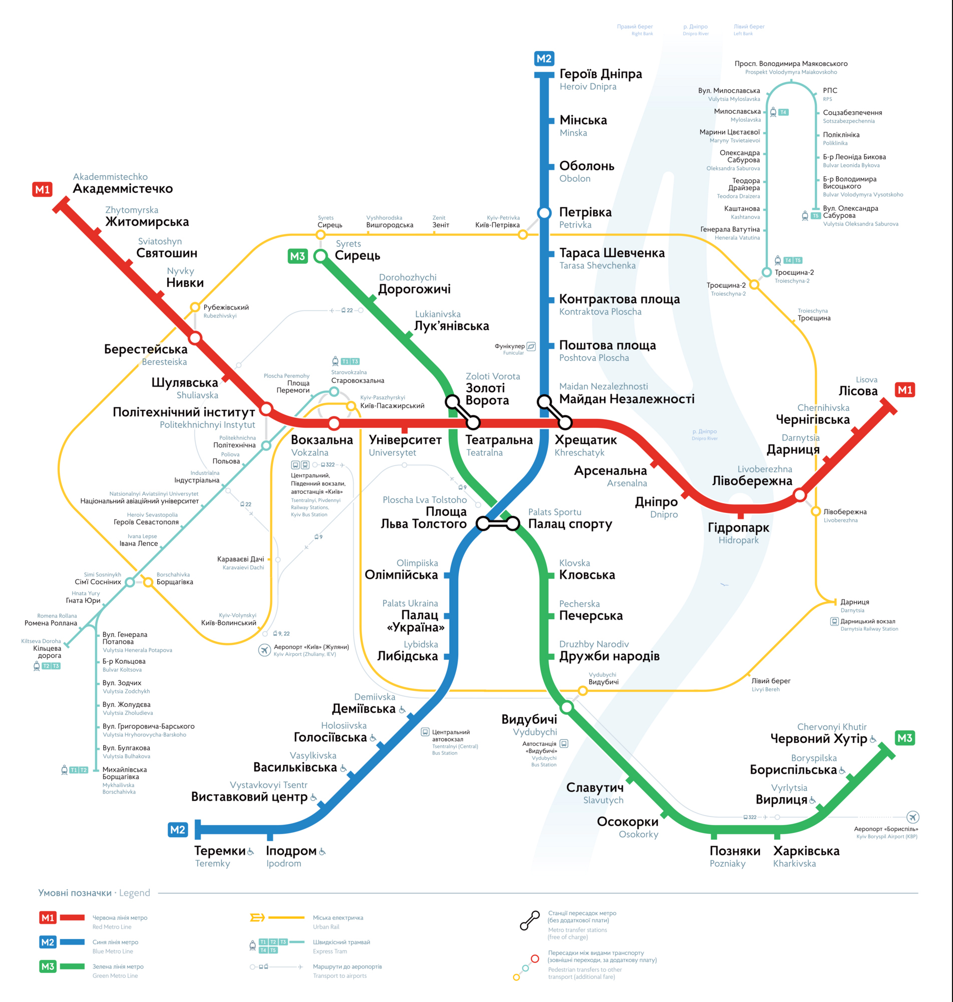
Kyiv Metro Map
Map of Kyiv Metro showing different lines. Click on the map to enlarge it or download the Kyiv Metro map in PDF format.
Lines and Stations
The Kyiv Metro has three operating lines that meet in the city centre, forming a triangular network. On the stations map and schematic route plan, station names appear in both English and Ukrainian, which makes transfers easier to follow.
Operating lines
| Station | Details |
|---|---|
| Line 1 | Sviatoshynsko-Brovarska Line (Red Line) |
| Line 2 | Kurenivsko-Chervonoarmiyska Line (Blue Line) |
| Line 3 | Syretsko-Pecherska Line (Green Line) |
Transfer stations
| Station | Details |
|---|---|
| Zoloti Vorota | Transfer with Teatralna (Green Line – Red Line) |
| Maidan Nezalezhnosti | Transfer with Khreschatyk (Blue Line – Red Line) |
| Palats Sportu | Transfer with Ploshcha Lva Tolstoho (Green Line – Blue Line) |
The stations list is straightforward, and the network map clearly marks interchange points. An interactive stations map is especially handy because it shows exact station coordinates.
One practical note: Kyiv Passenger Railway Station is next to Vokzalna station on the Red Line. There is no metro station at Boryspil International Airport or Kyiv International Airport.
Schedule and Timetables
Kyiv Metro operating hours vary slightly by station. As a general rule, stations open at 5:45 and close at 00:00, though individual opening times and closing time can differ.
The earliest opening is Boryspilska at 05:20, while the latest opening time is Syrets at 05:55. The earliest close is Ippodrom at 23:54, and the latest closing time is Teatralna at 00:18.
On major holidays such as New Year, Independence Day, and Easter, as well as some UEFA match evenings, working hours are extended by one hour. On football match days, Palats Sportu and Olympiiska usually close for entry and exit one hour before the match.
Train frequency depends on the time of day, day of week, and line. During rush hour, the last train gap is short and service timings are tighter. On weekend and holiday evenings, trains run less often.
| Service detail | Timings |
|---|---|
| General station opening hours | Usually 5:45 to 00:00 |
| Earliest opening station | Boryspilska – 05:20 |
| Latest opening station | Syrets – 05:55 |
| Earliest closing station | Ippodrom – 23:54 |
| Latest closing station | Teatralna – 00:18 |
| Rush hour frequency | 1 minute 30 seconds to 3 minutes |
| Weekend and holiday evening frequency | 5 to 10 minutes |
| Holiday extension | Usually one extra hour |
For schedule today, timings today, and the most accurate train schedule, Kyivskyi Metropoliten publishes current station operating hours and interchange timings online. If you need a route timetable or route map, it is also available there.
| Service detail | Timings |
|---|---|
| Red line | Approximate operating hours 05:30-23:00; typical interval 3-9 minutes |
| Blue line | Approximate operating hours 05:30-23:00; typical interval 4-10 minutes |
| Green line | Approximate operating hours 05:30-23:00; typical interval 3-9 minutes |
The metro usually runs from about 5:30 am to 11:00 pm, although station opening hours can vary a little. During an air raid alert, trains continue only on underground sections, so cross-river travel by metro is not available.
Prices, tickets and discounts
The Kyiv Metro is one of the cheapest public transport options in the city. A standard ticket price is 8 UAH (about $0.20) per ride, and the fare does not depend on distance or number of stations.
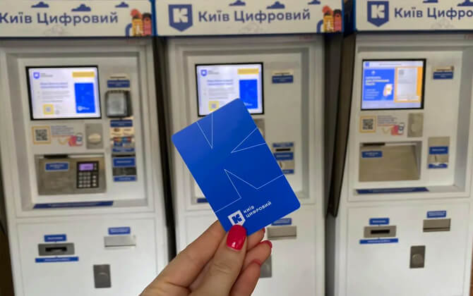
You can pay with a plastic token, load trips onto a contactless card, or use a bank card with PayPass or NFC at the turnstile. If you top up a Kyiv Smart Card in advance, the fare per ride drops.
- 1-9 trips – 8.00 UAH (about $0.20)
- 10-19 trips – 7.70 UAH (about $0.19)
- 20-29 trips – 7.40 UAH (about $0.18)
- 30-39 trips – 7.10 UAH (about $0.18)
- 40-49 trips – 6.80 UAH (about $0.17)
- 50 trips – 6.50 UAH (about $0.16)
A Kyiv Smart Card costs 50 UAH (about $1.25). The card includes a refundable deposit value of 15 UAH (about $0.37). It can be loaded with up to 50 trips per top-up and up to 100 trips in total. Unused trips are not refunded if the card expires.
There are also passes for regular riders. An unlimited monthly pass costs 610 UAH (about $15.25), and a half-month unlimited pass costs 305 UAH (about $7.63). Limited-ride pass options are also available.
- Monthly pass, maximum 62 trips – 390 UAH (about $9.75)
- Monthly pass, maximum 46 trips – 290 UAH (about $7.25)
- Half-month pass, maximum 31 trips – 195 UAH (about $4.88)
- Half-month pass, maximum 23 trips – 145 UAH (about $3.63)
- 10 trips valid for 5 days – 75 UAH (about $1.88)
- 14 trips valid for 7 days – 104 UAH (about $2.60)
- 30 trips valid for 15 days – 210 UAH (about $5.25)
For many visitors, a single ticket is the simplest option. If you are staying longer, a pass or card may be better value. Combination passes for buses, trams, and trolleybuses are also available as part of the wider city transport system.
There is no fare calculator in the source material, but the pricing is flat, so the cost stays the same no matter how long the route is.
Connections with Other Systems
Kyiv Metro is the backbone of transportation in Kyiv, but it works as part of a larger local transport network. It connects with urban rail, suburban rail, bus, trolleybus, funicular, and other city transport services.
In the city center, the three metro lines link through transfer stations, making cross-city travel much easier. Beyond the metro itself, Kyiv City Express connects with stations such as Sviatoshyn, Beresteiska, Livoberezhna, Pochaina, Syrets, and Vydubychi.
Vokzalna is especially important for rail connections because it links directly with Kyiv-Pasazhyrskyi railway station. Vydubychi also connects with Kyiv Boryspil Express and the railway station there.
Other transport modes extend the reach of the metro. These include Kyiv Light Rail, Kyiv Urban Electric Train, buses, trolleybuses, and the Kyiv Funicular. Together, they help cover areas that the underground system does not reach directly.
For transportation in Kyiv, the metro is best seen as the core of an integrated public transport system rather than a standalone service.
Connections to the Airports
Boryspil International Airport is linked to Kyiv by the Kyiv Boryspil Express, operated by Ukrzaliznytsia since 30 November 2018. The airport station is next to Terminal D, and the trip from Kyiv-Pasazhyrskyi usually takes about 30-40 minutes.
The service normally runs every hour, with trains every 30 minutes during peak periods. In Kyiv, it uses track 14 at Kyiv-Pasazhyrskyi station. The ticket price is 80 UAH (about $2.00).
Tickets can be bought at station cash desks, self-service terminals, or paid for on board by contactless card. There is no direct path train or metro route to either airport.
For Kyiv International Airport (Zhuliany), passengers can use trolleybus No. 9 to Kyiv Passenger Railway Terminal and Palace of Sports. There is no underground station at Boryspil International Airport or Kyiv International Airport.
- Boryspil Airport – Kyiv Boryspil Express, about 30-40 minutes, 80 UAH (about $2.00)
- Zhuliany Airport – trolleybus No. 9 to Kyiv Passenger Railway Terminal and Palace of Sports
Tips and Rules
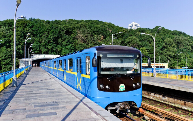
The Kyiv Metro is the city’s main transport system, with three lines and more than 50 stations. Most stations are underground, though a few are at ground level, so it helps to know your route in advance.
Look for the green M sign at station entrances. Some entrances are inside buildings, while others are reached through underpasses. In the lobby, you will usually find the ticket office marked Каси, vending machines, and turnstiles.
Single-ride tickets are sold as plastic tokens, and contactless payment is also available. Monthly passes and combined public transport passes exist, but they are usually most useful for frequent riders.
You generally do not need a strict timetable because trains are frequent. Services usually run from around 5:45 am until midnight or shortly after. In rush hour, frequency can be around every 2 minutes; later in the evening, it can stretch to 10 minutes.
On escalators, stand on the right and hold the handrail. At platform level, check the signs above the escalator so you do not end up on the wrong side. Inside trains, electronic displays show the next station, and station names are displayed in English as well.
The three main transfer points let you change lines without leaving the system or paying again.
| Station | Details |
|---|---|
| Teatralna – Zoloti Vorota | Red – Green transfer |
| Khreshchatyk – Maidan Nezalezhnosti | Red – Blue transfer |
| Ploshcha Lva Tolstoho – Palats Sportu | Blue – Green transfer |
There are a few basic rules. Bags are allowed if the total of length, width, and height is under 200 cm. Smoking is not permitted. Bikes are not allowed. Long items over 2.2 m are not permitted. Filming is not allowed, and you should not sit on escalators. Ice cream is also not allowed.
It is generally safe to use the system, though normal caution makes sense in crowded areas. Accessibility is limited: newer stations are more wheelchair-friendly, while many older central stations are not. Some stations have lifts or stairlifts, and 13 stations are accessible for wheelchairs.
History

The history of the Kyiv Metro goes back to 1884, when Dmytro Andrievskiy of the Southwestern railways proposed underground tunnels from Kyiv-Pasazhyrskyi railway station. The idea was discussed but rejected. Another proposal followed in 1916 from the Russo-American trading corporation, which argued that Kyiv needed cheap, fast, and safe transport because of the city’s growth and terrain, but that plan was also turned down.
After the fall of the Tsarist government, the metro was considered again under Hetman Skoropadsky, with plans tied to the Zvirynets district. Political change in 1918 and the Russian Civil War stopped progress.
Work returned in the 1930s after Kyiv became the capital of the Ukrainian SSR in 1934. In 1936, the Kyiv City Council reviewed a metro project by Papazov, and preparatory work began in 1938. World War II interrupted those early efforts.
After Kyiv’s liberation, the Soviet government revived the plan. In 1944 and 1945, official resolutions ordered the metro to be built, and experts studied passenger flows to choose the main route directions. Final preparations were completed in 1949, and Kyivmetrobud was established on 14 April that year.
Construction of the first line began in August 1949. The original plan called for seven stations, and a design competition followed in 1952. Some station designs were later revised after political changes made the original Stalinist style unsuitable. Construction was not easy because of groundwater, difficult soil, and funding delays.
A test run took place on 22 October 1960, and the Kyiv Metro officially opened on 6 November 1960 with a 5.24 km (3.26 mi) section from Vokzalna to Dnipro and five stations. That made it the first metro in Ukraine and the third in the former Soviet Union.
After opening, the system still faced practical problems, including the lack of a full depot and no direct railway connection. A temporary depot was set up near Dnipro station, and trains were delivered through Darnytsia railway station. Until 1962, most motormen came from Moscow because local training was not yet available.
The first line expanded in stages. In 1963, a 3.4 km (2.11 mi) section with Politekhnichnyi Instytut and Zavod Bilshovyk opened. In 1965, the line crossed the Dnieper via the Kyiv Metro Bridge and the Rusanivskyi Metropolitan Bridge, reaching residential districts on the east bank. Further extensions followed in 1968 and 1971.
The second line began construction in 1971 and opened in 1976 with three stations: Kalinina Square, Poshtova Ploshcha, and Chervona Ploshcha. It later expanded both north and south. In the 1980s, the network gained additional infrastructure, including a train repair plant and an extra passenger corridor where demand was especially high.
After Ukrainian independence, construction continued despite financial and technical difficulties. Druzhby Narodiv and Vydubychi opened in 1991, followed by Pozniaky and Kharkivska in 1994. In 2003, the first line finally extended westward with Zhytomyrska and Akademmistechko. The last major opening mentioned in the source material came in 2008 for Kyiv Day.
Future Extensions
The main future expansion project is the Podilsko-Vyhurivska line, planned as the fourth line of the Kyiv Metro system. It is intended to relieve overloaded transfer points and connect additional parts of the city.
According to the available route plan, the line is expected to be built in stages. The first section is planned to run from Vokzalna northward to Hlybochytska, where it would connect with Lukianivska on the Syretsko-Pecherska line.
Later sections are expected to continue toward Podil, cross the Dnieper River, and extend into the northern left-bank districts.
Other possible expansion plans mentioned in the source include extensions of the existing three lines, along with proposed Line 5 and Line 6 corridors. These projects are less certain and do not have fixed opening times.
The broader development program also includes modernization: new stations, more interchange points, depots, entrances, and upgrades to facilities and rolling stock.
Advice
For most people, the metro is the fastest and easiest way to get around Kyiv. It is especially useful for crossing between the right and left banks of the city, reaching the central railway station, and getting to major bus terminals and tourist areas.
The three lines are red (M1), blue (M2), and green (M3). You can check the route map, route timetable information, and transfer points online, and the same map is posted in stations and inside trains. Signs are clear, station names are announced in Ukrainian and English, and staff are present at every station.
A single ride costs 8 UAH (about $0.20). You can pay with a contactless bank card, phone, smartwatch, digital QR ticket in the Kyiv Digital app, or a paper ticket with a barcode. If you expect to ride often, a travel card can be more convenient than buying tickets one by one.
Trains usually run from around 5:30 am to 11:00 pm, depending on the line and station. Frequency is highest during rush hour, while waiting times are longer on weekend mornings and evenings.
During an air raid alert, metro service continues only on underground sections, and trains do not cross bridges over the Dnipro. In that situation, you will need ground transport or a taxi to travel between the two sides of the city. Underground stations remain open 24/7 as shelters with free access.
Like in any busy metro, keep an eye on your belongings and leave a little extra time during peak periods. Simple, but worth remembering.
Fun Facts
The Kyiv Metro opened on 6 November 1960 with just five stations and a 5.24 km (3.26 mi) line. It was the first rapid transit system in Ukraine and the third in the former Soviet Union.
Today the system has three lines, 52 stations, and 69.6 km (43.2 mi) of routes, of which 67.6 km (42.0 mi) are used for revenue service.
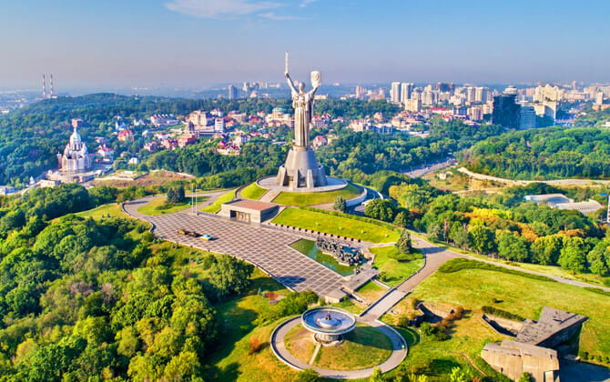
Arsenalna is the standout station. At 105.5 m below ground, it is the second deepest metro station in the world.
The metro also plays a huge role in daily mobility. In 2016, it carried 484.56 million passengers, or around 1.32 million per day. In 2014, it handled 46.7% of Kyiv’s public transport load.
Kyiv Light Rail and Kyiv Urban Electric Train are part of the city’s wider transport picture, but they are separate systems run by different operators.
During the full-scale Russian invasion, the metro took on another role as a shelter system. All underground stations remained open 24 hours a day for that purpose, and on 2 March 2022, Kyiv’s mayor said up to 150,000 residents had taken refuge there.
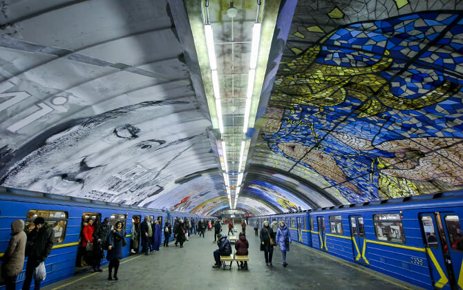
Many stations are known for their Soviet-era design, with granite, marble, mosaics, and Ukrainian decorative motifs. So yes, it is transport, but it is also architecture worth noticing.
The three-line triangular layout in the city center is another distinctive feature, typical of Soviet metro planning.
There were also some unusual moments in its operating history, including the use of an overhead crane to move trains to the first depot before a permanent depot existed, and the transfer of Leningrad metro trains to Kyiv in 1969.
Tourism and Sightseeing
Kyiv Metro is not just a way to move around the city. It is also a sightseeing experience, thanks to its history, station architecture, and famous deep-level platforms such as Arsenalna.
Guided metro tour highlights
A guided tour begins at Independence Square near the Globe Column, then heads underground to Maidan station. From there, visitors ride Kyiv’s blue metro cars through some of the system’s best-known stations while learning about their art, design, and history.
| Station | Details |
|---|---|
| Khreschatyk | Included on the guided tour |
| Arsenalna | 105.5 m below ground |
| Zoloti Vorota | Often considered one of the city’s most beautiful stations |
| Teatralna | Included on the guided tour |
| Universytet | Included on the guided tour |
| Golosiivs’ka | Included on the guided tour |
| Hippodrome | Included on the guided tour |
| Kontraktova Ploscha | Included on the guided tour |
At Arsenalna, the tour continues into the historic Pechersk neighborhood for photos of monuments and the former Arsenal Factory. At Zoloti Vorota, visitors can admire lamps, arches, and mosaics with themes from the cultural heritage of Kyivan Rus’.
Self-guided sightseeing ideas
If you prefer to explore on your own, the metro is a low-cost way to see some of Kyiv’s most interesting stations. A self-guided route can include Zoloti Vorota, Teatralna, Khreschatyk, Universytet, Arsenalna, Palats Ukraina, and Demiivska.
These stations are known for varied design styles, from marble archways and statues to chandeliers, mosaics, and spacious modern halls. Many are easy to spot thanks to the green M sign, and several connect directly with major sightseeing areas.
The metro is cheap, fast, and practical, so it works well for moving between landmarks while also giving you a closer look at some of Kyiv’s most impressive underground spaces.
See more of Kyiv
You can also combine a metro visit with other sightseeing activities around the capital, including food tours and broader city walks.
Important Information
Bring cash on the day of the tour if you need to buy public transport tickets or entry tickets to monuments for yourself and your guide.