The Mexico City Metro, or Metro de la Ciudad de México, is the rapid transit system that serves Mexico City and some municipalities in the State of Mexico. Operated by Sistema de Transporte Colectivo (STC), it is the second largest metro system in North America after the New York City Subway. The system opened on 4 September 1969 with a 12.7 km (7.9 mi) line and 16 stations. As of 2015, it had grown to 12 lines, 195 stations, and 226.49 km (140.7 mi) of route. Ten lines use rubber-tired trains for quieter, smoother travel on the city’s unstable soil, while 44 transfer stations connect two or more lines across the network.
| Key | Information |
|---|---|
| Operator | Sistema de Transporte Colectivo (STC) |
| Opened | 4 September 1969 |
| Lines | 12 |
| Stations | 195 |
| Route length | 226.49 km (140.7 mi) |
| Transfer stations | 44 |
| Daily operating hours | From 5:00 a.m. to 12:00 a.m., depending on the day |
| Track types | Rubber-tired trains on 10 lines; steel tracks on Line A and Line 12 |
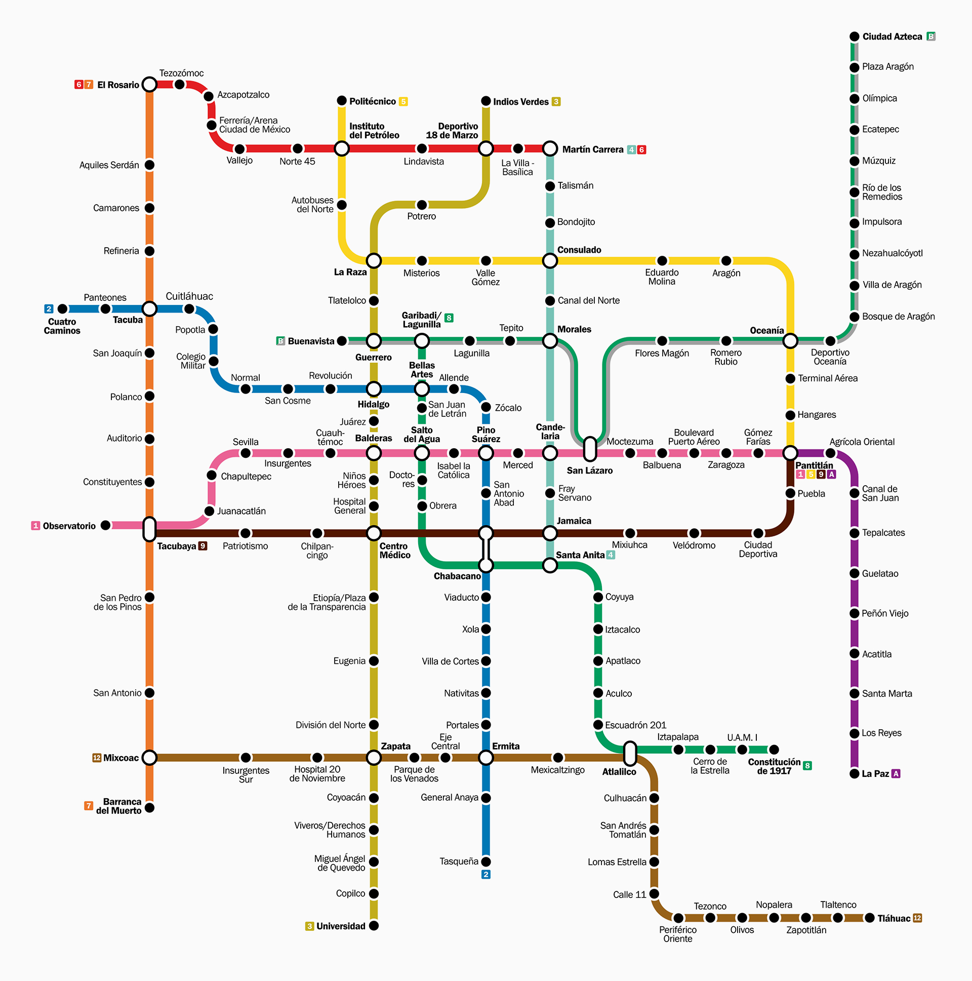
Mexico City Metro Map
Map of Mexico City Metro showing different lines and stations. Click on the map to enlarge it or download the Mexico City Metro map in PDF format.
Mexico City Metro Line and Stations
The Mexico City Metro system covers the capital and part of the wider metropolitan area. Since Line 1 opened in 1969, the network has expanded to 12 lines and 195 stations. By 2015, the full route reached 226.49 km (140.7 mi). Ten lines use rubber-tired trains, while Line A and Line 12 run on steel railway tracks.
For trip planning, the stations map and stations list are especially useful because the network includes underground, surface, and elevated sections. The system has 115 underground stations, 54 surface stations, and 26 elevated stations.
Line structure and station layout
Each line has its own number or letter and color, and station logos match the line color. Line B is the one exception, using green and gray together. Transfer stations, known as correspondencias, play a major role in the route plan, with 44 stations linking two or more lines.
Station names often refer to historical figures, places, or events in Mexican history. The minimalist station logos are one of the metro’s most recognizable features and help riders navigate the system.
Main lines and terminals
| Station | Details |
|---|---|
| Line 1 | Observatorio to Pantitlán |
| Line 2 | Cuatro Caminos to Tasqueña |
| Line 3 | Indios Verdes to Universidad |
| Line 4 | Martín Carrera to Santa Anita |
| Line 5 | Politécnico to Pantitlán |
| Line 6 | El Rosario to Martín Carrera |
| Line 7 | El Rosario to Barranca del Muerto |
| Line 8 | Garibaldi / Lagunilla to Constitución de 1917 |
| Line 9 | Tacubaya to Pantitlán |
| Line A | Pantitlán to La Paz |
| Line B | Ciudad Azteca to Buenavista |
| Line 12 | Mixcoac to Tláhuac |
Line 12 opened on 30 October 2012 and, at 24.31 km (15.1 mi), became the longest line in the system. It was designed to extend service toward the southeastern part of the city and connect with Lines 7, 3, 2, and 8.
Future stations
An expansion of Line 12 toward Observatorio is under construction. The planned stations are Álvaro Obregón and Valentín Campa. According to the source material, both are under construction and expected to open in 2028.
Operating Hours
The Mexico City Metro operates every day of the year. If you are checking operating hours, opening hours, opening times, or timings today, the schedule depends on the day of the week.
| Service detail | Timings |
|---|---|
| Monday to Friday opening hours | 5:00 a.m. to 12:00 a.m. |
| Saturday opening times | 6:00 a.m. to 12:00 a.m. |
| Sunday and holiday working hours | 7:00 a.m. to 12:00 a.m. |
| Weekday morning busy period | 6:00 a.m. to 10:00 a.m. |
| Weekday afternoon busy period | 5:30 p.m. to 9:00 p.m. |
The closing time is midnight every day, though the starting time changes on weekends and holidays. If you want a quieter trip, avoid the busiest commute periods, when trains and stations can get very crowded. For late trips, it is smart to keep an eye on the last train window and leave a bit of extra time before the system starts to close.
Mexico City Metro Fares and Tickets
The standard fare for a single ride is MXN 5 (about USD 0.29). One ticket lets you travel anywhere in the metro system and transfer as many times as needed without extra cost.
Riders can use a rechargeable Metro Card, available at stations and at vending machines in Metrobús stations. The card itself costs MXN 10 (about USD 0.58). Paper tickets are no longer used in the system as of February 2024, so passengers now need a rechargeable card.
For many locals and visitors, the low fare and simple ticket price make the metro one of the most affordable public transport options in the city. The source material does not mention a fare calculator, day pass, or pass product for the metro itself.
The train schedule follows the same timetable every week:
| Service detail | Timings |
|---|---|
| Monday to Friday schedule | 5:00 a.m. to 12:00 a.m. |
| Saturday schedule | 6:00 a.m. to 12:00 a.m. |
| Sunday and holiday schedule today | 7:00 a.m. to 12:00 a.m. |
The source material does not provide station parking, parking charges, or parking charges per day information.
Connections to Other Systems
The Mexico City Metro connects with several other city transport and local transport systems, although these are not part of the STC network itself. In each case, an extra fare is required.
The metro links with Metrobús, Mexibús, the Mexico City light rail system, and the Ferrocarril Suburbano commuter rail. A shared smart card can be used on some of these public transport services, including the metro and Metrobús.
One of the most important rail connections is at Tasqueña, where Line 2 meets the light rail route to Xochimilco, operated by Servicio de Transportes Eléctricos. Buenavista is another key interchange, connecting with Ferrocarril Suburbano, while Line 6 connects with that commuter rail system at Fortuna. Observatorio is also planned to connect with the intercity rail line between Mexico City and Toluca.
Several stations connect with Metrobús lines, including Indios Verdes, La Raza, Chilpancingo, Balderas, Etiopía / Plaza de la Transparencia, Insurgentes Sur, Tacubaya, Cuauhtémoc, Pino Suárez, and San Lázaro. Most transfers happen outside the paid area, though the same card may be used for payment.
Line 12 was designed with strong transfer potential as well. Its route connects with other metro lines at Zapata, Ermita, and Atlalilco, and the planned extension to Observatorio would create another major interchange in the transportation in Mexico City network.
Airport Connections
Mexico City Metro Line 5 serves Terminal Aérea, the station closest to Terminal 1 at Mexico City International Airport. It is one of the cheapest airport transport options in the city, with a single ride costing MXN 5.00 (about USD 0.29). To use the metro, you need an Integrated Mobility Card, which can be bought and reloaded at station machines.
The metro has a direct connection only to Terminal 1. If you are flying from Terminal 2, you need to reach Terminal 1 first and then continue by Aerotrén or the inter-terminal shuttle bus. That extra connection can add around 20 to 30 minutes to your running time, so it is worth planning ahead.
For travelers with light luggage, the metro is a practical and low-cost choice because it connects easily with the wider city transport system. The station and line usually have a police presence, and the trip is generally considered safe. Even so, stay alert, watch your belongings, and try to avoid peak hours if you can.
Terminal Aérea station is on Boulevard Puerto Aéreo, a short walk from Terminal 1.
| Service detail | Timings |
|---|---|
| Monday to Friday operating hours | 5:00 a.m. to 12:00 a.m. |
| Saturday operating hours | 6:00 a.m. to 12:00 a.m. |
| Sunday and holiday operating hours | 7:00 a.m. to 12:00 a.m. |
Accessibility
The Mexico City Metro includes accessibility features for people with disabilities, older adults, and other passengers who may need additional support. Guide dog access is allowed at all stations, and trains include reserved seating. Each car has four reserved seats, for a total of 10,584 across the system.
Selected stations have accessibility features such as elevators and electromechanical stairs. The source material mentions stations including Centro Médico, Chabacano, Copilco, Cuauhtémoc, Politécnico, Potrero, Puebla, Tacubaya, and Zócalo.
Accessibility is not uniform across the whole route. In practice, some stations may have an elevator at street level but not all the way to the platform, so station-specific access can vary. Because of that, checking station details before you travel is a good idea.
One source also notes that some elevators may be reserved for people with disabilities and can be unlocked by station police or with a special access card.
For some passengers, the Metrobús may be a more accessible public transport option than the metro because it runs above ground and includes designated cars for people with disabilities and women. Still, not every stop is accessible, so it is best to confirm conditions before boarding.
Interesting Facts
The Mexico City Metro is the second largest metro system in North America after the New York City Subway. It started service on 4 September 1969 with a 12.7 km (7.9 mi) line and 16 stations, and by 2015 it had expanded to 12 lines, 195 stations, and 226.49 km (140.7 mi) of route.
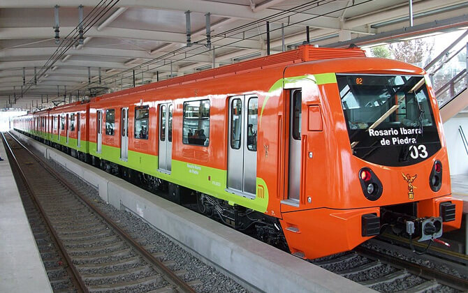
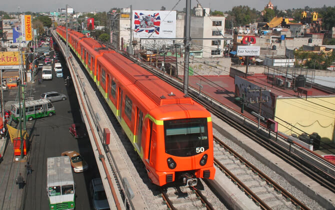
One of its most distinctive features is the use of rubber-tired trains with pneumatic traction on ten lines. This technology was chosen because it offers a quieter, smoother ride on Mexico City’s unstable soil.
The system also proved resilient during the 1985 Mexico City earthquake. Service was shut down for safety, but the metro structure itself was not damaged.
Transfers are a central part of the network, with 44 stations serving two or more lines. The system includes 115 underground stations, 54 surface stations, and 26 elevated stations.
Many stations are named after historical figures, places, or events, and every station has a minimalist logo. This visual identity was designed by Lance Wyman and remains one of the best-known parts of the system.
Metro construction has also uncovered more than 20,000 archaeological finds. At Pino Suárez station, the altar to Ehécatl is regarded by INAH as the smallest archaeological site in Mexico.
Line 12, fully opened on 30 October 2012, is the longest line in the system. It also introduced steel railway tracks and access by Tarjeta DF smart card.
The metro has had a wider cultural impact too, appearing in films, inspiring music, and becoming part of everyday life in the city.
History
By the second half of the twentieth century, Mexico City was facing serious public transport problems. Roads and highways were heavily congested, especially in the center, and with bus and electric transport already carrying most passengers, the city needed a new mass transit system.
The main promoter of the Mexico City Metro was engineer Bernardo Quintana, who led the studies behind the early route plan. The system became official on 29 April 1967, when the presidential decree created the Sistema de Transporte Colectivo as a decentralized public organization to build and operate the metro.
French technical assistance played an important role in the early years. RATP’s engineering branch, SOFRETU, contributed to planning and to the design of the first lines, including the tyre-and-rail technology choice. The inauguration ceremony took place on 19 June 1967, and daily service began on 4 September 1969 with the first trip between Zaragoza and Insurgentes.
The first construction stage included Lines 1, 2, and 3, built by Grupo ICA. Work moved quickly, at a pace of at least 1 km (0.6 mi) of track per month. During construction, workers uncovered archaeological remains, including Aztec artifacts and mammoth bones now displayed at Talismán station.
By 10 June 1972, the first stage had produced 48 stations and 41.41 km (25.7 mi) of track. Line 1 ran from Observatorio to Zaragoza, Line 2 from Tacuba to Tasqueña, and Line 3 from Tlatelolco to Hospital General.
A second expansion stage began during José López Portillo’s administration. Line 3 extended north to La Raza and then Indios Verdes, and also moved south toward Centro Médico and Zapata. Lines 4 and 5 were built and completed in 1982, with Line 4 becoming the first elevated metro line in the STC system.
The third stage, from 1983 to 1985, extended Lines 1, 2, and 3 to their current lengths and added Lines 6 and 7. Line 7 was built as a deep-bore tunnel. On 19 September 1985, an 8.0 magnitude earthquake struck the city. The metro was not structurally damaged and later proved to be a reliable transport option during the crisis, although service was temporarily suspended and several stations were closed for rescue work and debris removal.
The fourth stage completed Line 6 and extended Line 7 north to El Rosario. Line 9 was also built during this period and later extended to Tacubaya.
In the fifth stage, Line A became the first line to run into the State of Mexico. Built almost entirely above ground, it used steel rails and overhead lines instead of pneumatic traction. Line 8 was redesigned to avoid damage to colonial buildings and Aztec ruins near the city center, and construction was completed in 1994. By then, the network had grown to 10 lines, 154 stations, and 178.1 km (110.7 mi) of route.
The sixth stage brought Line B, intended to serve northeastern municipalities in the State of Mexico. It opened in two parts between 1999 and 2000.
The most recent major expansion in the source material is Line 12. Planning began in 2008, construction was delayed, and the line became fully operational on 30 October 2012. With minor changes, it runs from Mixcoac to Tláhuac and became the first line to serve southern Mexico City in this way. In 2015, new stations and a terminal were announced to connect it with Line 1 and improve access to Observatorio.
Beyond expansion, the metro’s construction has led to more than 20,000 archaeological finds, helping researchers better understand the region’s ancient history. The system has also shaped the identity of the city through its design, symbols, and cultural presence.
Key milestones in the history of the Metro:
- 1967: the system was officially created and construction began
- 4 September 1969: the first line opened to the public
- 1972: the first construction stage was completed
- 1985: the Metro remained resilient during the earthquake
- 1991–2000: Lines A and B extended service into the State of Mexico
- 2012: Line 12 entered full operation
Future Extensions
The latest confirmed expansion work focuses on strengthening transfer points rather than adding a completely new line. The clearest project in the source material is the western extension of Line 12 from Mixcoac to Observatorio, with two new intermediate stations.
This extension matters because it would connect Line 12 with Line 1 at Observatorio and improve access to a major transport hub. It is also tied to the broader development of the Observatorio area, where a new intercity rail terminal is planned for the Mexico-Toluca corridor.
In the available material, Observatorio is described as a future interchange point for the metro, the intercity train, and other local transport services. That would make it one of the most important transfer nodes in the network.
Beyond the metro itself, other rail projects in Mexico City are also expected to connect with the system, especially the Mexico-Toluca interurban line. Once completed, it will bring regional rail service directly to Observatorio and extend the reach of the city’s transportation network.
For now, the main direction of expansion is clear: extend existing lines, improve connections, and integrate the metro more closely with commuter rail and other transport modes.
Nearby Attractions
Many of Mexico City’s best-known attractions are easy to reach by metro, especially around Centro Histórico, Alameda Central, Reforma, Chapultepec, and Coyoacán. In many cases, several sights are close enough to combine in one outing.
A practical tip: many museums and major attractions are closed on Mondays, while Sundays are often the busiest because of free admission for locals and residents. Students with an ISIC card may also be able to save money at some museums and attractions.
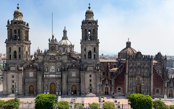
- Centro Histórico: Zócalo, Catedral Metropolitana, Templo Mayor, Palacio de Bellas Artes, Torre Latinoamericana, Casa de los Azulejos, Chinatown, and Alameda Central are close together and easy to visit in one day.
- Reforma area: Paseo de la Reforma, the Angel of Independence, and the Monument to the Revolution are all convenient by metro.
- Chapultepec: This area includes Chapultepec Park, the National Museum of Anthropology, Chapultepec Castle, lakes, the zoo, and several other museums and gardens.
- Coyoacán: Casa Azul is one of the city’s most popular attractions, though lines can be long.
- Northern Mexico City: The Basilica of Guadalupe is a major pilgrimage site and can be reached by metro.
If you want something a little different, the metro itself can be part of the sightseeing. Some stations include murals, archaeological remains, themed installations, and even a small museum, so the trip can be part of the experience too.