Amsterdam has an extensive public transport system run largely by GVB, with tram, metro, bus, ferry, and train connections across the city and beyond. For visitors and residents alike, it is a practical way to move between neighborhoods, major sights, and transport hubs, with frequent services, simple ticket options, and easy route planning through OVpay, 9292, and GVB stations map tools.
| Key | Information |
|---|---|
| Main city transport operator | GVB |
| Transport modes | Tram, metro, bus, ferry, and train |
| Main payment option | OVpay with bank card, smartphone, or smartwatch |
| Pass options | GVB day pass and multi-day ticket options |
| Trip planning | 9292 and GVB website maps |
| Use pattern | Check in at the start and check out at the end of the journey |
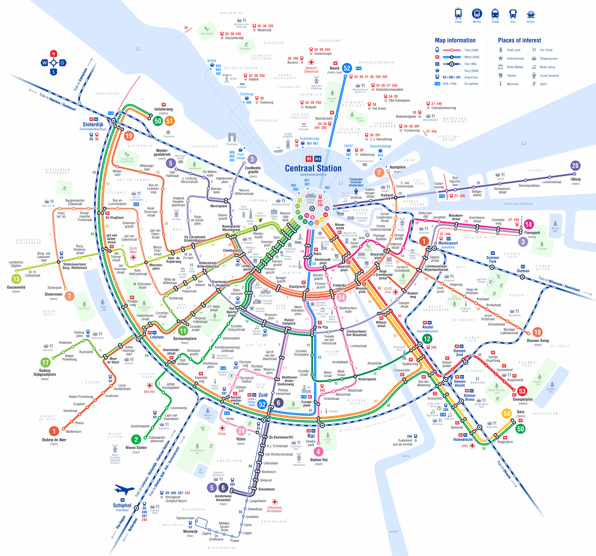
Map of Public Transportation System in Amsterdam
Map of Public Transportation System in Amsterdam showing different lines. Click on the map to enlarge it or download the map of Public Transportation System in Amsterdam in PDF format.
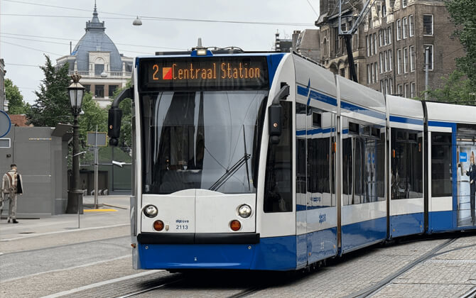
Tram service in Amsterdam
Amsterdam’s tramway is a core part of city transport and one of the largest tram systems in Europe. Operated by GVB since 1943, it remains one of the most useful ways to travel through central districts and many outer neighborhoods.
Network overview
The tram network has 15 lines. It serves all boroughs in Amsterdam except Amsterdam-Noord on the north side of the IJ and Amsterdam Zuidoost. Some routes continue beyond the city too: lines 5 and 25 run into Amstelveen and Uithoorn, while line 19 reaches Diemen.
As of April 2022, the fleet included 227 trams: 155 Combino trams from Siemens and 72 Urbos 100 trams. The first 15G trams entered service on line 25.
Types 14G and 15G are bi-directional and are used on lines 5 and 25, where termini do not have turning loops. Other routes use unidirectional trams and loops. Lines 25 and 26 can also operate paired trams, and both follow a largely separate route away from normal road traffic.
In 2020, the tram system covered 14 lines, 95 kilometers (59 miles) of routes, 200 kilometers (124 miles) of standard-gauge track, 650 switches, and 500 tram stops. The fleet ran almost 12 million kilometers (7.5 million miles) in service, using 45 million kilowatts of electricity per year from green sources.
History
Amsterdam’s first horse-drawn tramway opened on June 3, 1875, linking Plantage and Leidseplein. The system was first operated by AOM and later became Gemeentetram Amsterdam after the municipality took over in 1900. Electric trams began running in 1900, and by 1906 almost the whole network had been electrified and converted to standard gauge.
The network grew quickly in the early 20th century and reached its largest size in 1931, with 25 tram lines. After service cuts during the Great Depression and wartime disruptions, operations resumed after World War II. In the 1950s and 1960s, some lines were replaced by bus routes, though trams stayed essential on narrow streets such as Leidsestraat and Utrechtsestraat.
From the 1950s onward, modern articulated trams helped secure the future of the system. Later years brought low-floor vehicles, new links to Amstelveen and Diemen, and a major fleet renewal with Siemens Combino trams between 2002 and 2004.
After the North-South metro line opened in 2018, the tram route plan was reorganized to improve interchange with the metro for cross-city travel. Line 19 was reintroduced, line 11 returned in a revised form, and line 25 was rebuilt as a tram line. Since 2020, line 25 has served Westwijk, with a future expansion planned toward Uithoorn. In 2021, line 27 started supplementary rush-hour service, and in 2024 GVB was working with the regional transport authority on a plan to convert the tram system from 600 to 750 volts.
Useful notes for passengers
- Trams are a practical way to reach many major attractions in Amsterdam.
- Line 2 is especially popular for sightseeing, with stops near the flower market, Royal Palace, Rijksmuseum, Van Gogh Museum, and Stedelijk Museum.
- Tickets can no longer be bought with cash on board.
- You must check in and out, and only doors marked with the Welkom sticker are for entry.
- GVB also runs the metro, city bus network, and ferries, so transfers are usually straightforward.
Bus network in Amsterdam
Amsterdam’s bus network is broad, practical, and especially useful in areas not served by the tram. It connects neighborhoods across the city and also reaches into the wider Amsterdam Metropolitan Area.
The main operators are GVB for many local transport services within Amsterdam, with Connexxion and EBS covering regional routes. Many bus services run to and from Amsterdam Central Station, one of the main hubs in the public transport system.
When using the bus, you need to check in at the start and check out at the end of the trip. If you change buses, you must repeat the process. You can use OVpay or buy a ticket from the driver.
Amsterdam has 44 bus lines, including night buses, so the network plays a major role in city transport and transportation in areas beyond the tram route.
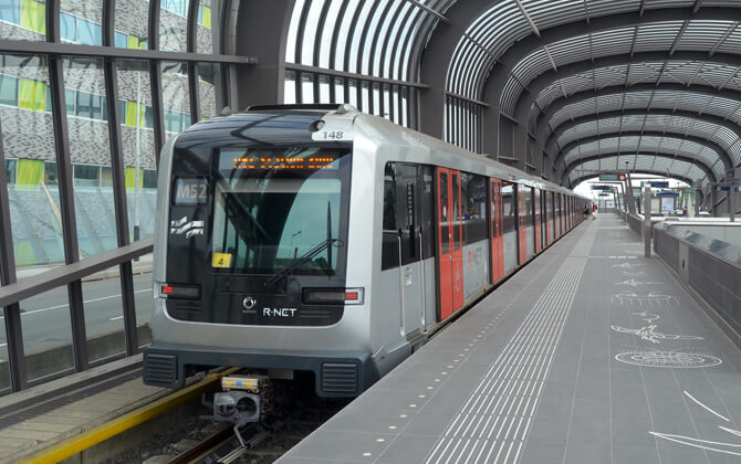
Subway Network in Amsterdam
Amsterdam’s metro system is an important part of public transport in the city and surrounding municipalities. Operated by GVB, it currently has 5 lines and 39 stations. It does not cover every part of the urban area, but districts outside the metro network are usually served by strong tram, bus, ferry, or train links.
Most metro routes pass through or terminate at Amsterdam Central Station, making it a key interchange. The five lines are numbered 50, 51, 52, 53, and 54. Line 50 is the ring line and does not pass through Central Station, while line 52 runs between Noord and Zuid via Centraal Station.
For ticketing, OVpay is one of the easiest options. You can check in and out with a bank card, smartphone, or smartwatch when using the tram, bus, metro, or train. If you prefer a pass, the Amsterdam & Region Travel Ticket offers one, two, or three days of unlimited travel on GVB, Connexxion, AllGo, R-net, EBS, and NS services in Amsterdam and the region.
For route planning, timetable checks, and stations map tools, you can use 9292 or the GVB website. GVB also provides information on accessibility, including which stations and stops are wheelchair accessible and which services have ramps.
If the metro does not take you exactly where you need to go, the wider transport system makes connections easy. Ferries provide free crossings to Amsterdam Noord, and trains link the city with Schiphol, other Dutch cities, and international destinations.
Taxi service in Amsterdam
Taxis are a convenient transport option in Amsterdam, especially late at night or when public transport is less practical. You can use traditional licensed cabs or app-based services such as Uber and Bolt.
Types of taxis in Amsterdam
There are two main ways to get a taxi in Amsterdam:
- Hail a taxi or use a designated taxi stand. Official taxis have blue license plates and an official roof sign.
- Order through an app such as Uber or Bolt, where you can track the driver in real time.
Taxi fares and payments
Taxi fare in Amsterdam is metered, with a starting price of around €4.15 ($4.47). A taxi bus for five to eight passengers has a boarding rate of €8.44 ($9.10).
Drivers must take you safely to your destination by the shortest or quickest route. At the end of the trip, the meter shows the total cost. It is smart to ask for a receipt.
If you book through an app, you will usually see a fixed ticket price or fare before the ride starts.
Taxi pick-up points
You can find taxi stands at Schiphol Airport and at all train stations in the city. Notable locations include Amsterdam Central Station, Amsterdam Zuid Station, and Johan Cruijff ArenA.
There are also taxi stands at major squares and entertainment areas:
| Station | Details |
|---|---|
| De Dam | Major central square with taxi stand |
| Leidseplein | Busy entertainment area with taxi stand |
| Museumplein | Popular museum district pick-up point |
| Nieuwmarkt | Central area with taxi stand |
| Rembrandtplein | Nightlife district with taxi stand |
What to keep in mind
Only use taxis with a blue license plate. Unlicensed vehicles should be avoided to reduce the risk of scams. If you lose an item or want to leave feedback, contact the taxi company linked to the vehicle. For Uber, Bolt, and similar services, use the app.
If you experience discrimination, you can file a complaint through the National Discrimination Hotline or use the Report it Always option for LGBTQI+ cases.
Licensed Permitted Taxi Organisations in Amsterdam include Schipholtaxi, Staxi B.V., Stichting Take a Taxi, Taxi Centrale Amsterdam B.V., Taxi Direct B.V., Taxistad B.V., and TCS.
Alternative ways to get around
Taxis are quick, but they are not always the most budget-friendly option. Amsterdam is easy to explore on foot, by bike, or with its strong public transport system, so these alternatives are often worth considering.
Waterways in Amsterdam
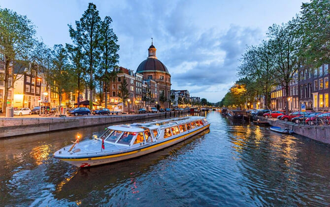
Amsterdam’s waterways are one of the city’s defining features. More than 150 canals run through Amsterdam and nearby areas, dividing the city into about 90 small islands and connecting them with more than 1,000 bridges. For centuries, the canals were vital transport routes for goods such as food, spices, coal, and water.
Today, the canals are used mainly by smaller barges, pleasure craft, and canal tour boats. They are still part of the transport system through water taxis, canal buses, boat sharing, and ferry services. DHL also uses parcel boats to deliver packages through the city.
Ferries are especially important in local transport. They provide free crossings for pedestrians, cyclists, and mopeds, especially between Amsterdam Central Station and Amsterdam Noord. The Buiksloterweg route has the highest frequency and runs through the night, while other main routes connect to NDSM Wharf and IJplein.
In the wider Amsterdam Metropolitan Area, ferries also cross the North Sea Canal. These services can carry motorized vehicles for a small fee, adding another layer to water-based public transport.
Other services are more visitor-focused, but still useful. Canal buses, canal cruises, water taxis, and canal bikes all offer different ways to travel or explore the city from the water.
| Water transport type | Main use |
|---|---|
| Ferries | Free crossings for pedestrians, cyclists and mopeds |
| Canal buses | Regular routes with stops in tourist and shopping areas |
| Water taxis | Small private trips for up to eight passengers |
| Canal bikes | Pedal boat rental for leisure travel |
Although Amsterdam public transport is often associated with trams, buses, metro lines, and trains, the waterways remain an essential part of the city’s transport landscape.
Airport Connections
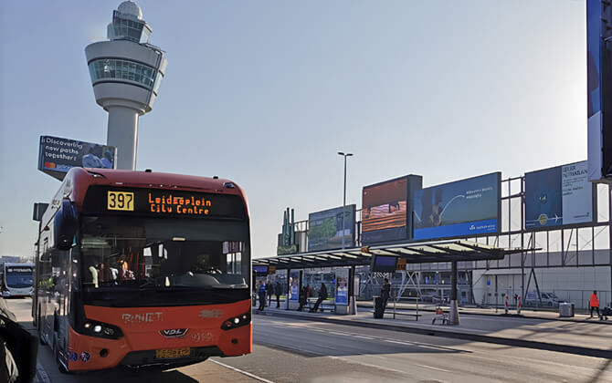
Schiphol Airport is about 12 kilometers (7.5 miles) southwest of Amsterdam in a straight line. The fastest and easiest ways to reach the city are by train, bus, or taxi.
| Method | Time / Cost | Best For |
|---|---|---|
| Train | 13-17 min, €5-6 ($5.39-$6.47) | Most visitors |
| Bus 397 | 28-38 min, €6.50 ($7.01) | Visitors staying near Leidseplein or the Museum Quarter |
| Taxi | 25-45 min, €50-70+ ($53.90-$75.46+) | Door-to-door comfort or lots of luggage |
| Private Transfer | 25-45 min, €55-90+ ($59.29-$97.02+) | Groups, families, or lots of luggage |
| Cruise Terminal Transfer | 30-50 min, €60-100+ ($64.68-$107.80+) | Hassle-free transfer from the airport or hotel |
For most travelers, the train is the best choice because it is direct, frequent, and usually the fastest route to Amsterdam Central Station. Bus 397 is a good alternative if your hotel is closer to Museumplein, Leidseplein, or the Jordaan area.
Taxis and private transfers cost more, but they can be useful if you want direct door-to-door travel or have a lot of luggage. There is currently no metro line serving Schiphol Airport.
Tips and Rules
Amsterdam’s public transport network is extensive and easy to use once you know the basics. The system combines train, tram, metro, bus, and ferry services, with GVB covering much of the main city transport network.
The most important rule is simple: always check in and check out. This applies when you board a tram, bus, metro, or train, and when you finish your trip. If you change trams or buses, you must check out and check in again. For metro travel, use the station gates and check out only at the end of the journey.
OVpay is a convenient option if you do not want to buy a separate ticket in advance. You can use a contactless debit card, credit card, smartphone, or smartwatch, and the trip cost appears in your bank account overview.
If you travel with GVB and use OVpay, your daily fare is capped at €10.00 per day ($10.78) for unlimited travel on all GVB lines. If you expect to travel a lot, a GVB day pass or multi-day pass can also be a practical choice.
Other options include the I amsterdam City Card, which includes unlimited public transport for 24, 48, 72, 96, or 120 hours, and the Amsterdam & Region Travel Ticket, which covers transport in Amsterdam and the wider region.
For route planning, stations list checks, and schedule tools, 9292 and the GVB website are the easiest places to start.
- Use 9292 or the GVB website to check route timetable information before you travel.
- Remember that tram, bus, metro, and ferry each cover different parts of the city.
- Trains are the best option for Schiphol Airport and destinations beyond Amsterdam.
- GVB and NS provide accessibility information for trams, buses, metro, and trains.
- Ferries across the IJ are free for pedestrians, cyclists, and mopeds.
- Train tickets can be bought online, from ticket machines, or at station service desks.
Nearby Attractions
Amsterdam is compact, walkable, and easy to explore from its UNESCO-listed canal ring. Many of the city’s best-known sights are close together, so it is easy to combine walking with trams, buses, metro lines, or the free ferries across the IJ.
On foot, the historic center is ideal for wandering. Following the main canals and understanding the basic route plan of the central canal ring makes it easier to reach places such as Dam, Leidseplein, and Rembrandtplein.
By bike, you can reach parks, quieter neighborhoods, and open spaces beyond the busiest streets. Bike hire is widely available, which makes this a flexible alternative to public transport.
By tram, bus, and metro, the city center connects well with outer districts, while the free ferry behind Centraal Station is a handy link to Amsterdam Noord and other areas across the river.
If you are arriving from Schiphol Airport, frequent NS trains to Amsterdam Centraal are usually the quickest option. The Amsterdam Airport Express bus is also practical for areas near Museumplein and Leidseplein.
For visitors planning to see several attractions, GVB tickets and the I amsterdam City Card can make getting around simpler.