The SEPTA Subway-Surface Trolleys, now officially branded as the T, are a light rail system serving Philadelphia and Delaware County, Pennsylvania. The system combines underground running beneath Market Street in Center City with street-level trolley service in West Philadelphia and Delaware County. Its five routes are 10, 34, 13, 11, and 36, now shown as T1 through T5, and together they cover about 39.6 miles (63.7 km). The T is part of SEPTA Metro and remains a core piece of public transportation in Philadelphia.
| Key | Information |
|---|---|
| System name | SEPTA Subway-Surface Trolleys, branded as the T |
| Type | Light rail and street-running trolley system |
| Routes | T1 / Route 10, T2 / Route 34, T3 / Route 13, T4 / Route 11, T5 / Route 36 |
| Main corridor | Shared tunnel under Market Street, then surface routes west and southwest |
| Coverage | Philadelphia and Delaware County, Pennsylvania |
| Total route length | About 39.6 miles (63.7 km) |
| Base fare | $2.90 USD per trip |
| Key transfer points | 13th Street, 15th Street / City Hall, 30th Street, Suburban Station, and 40th Street during diversions |
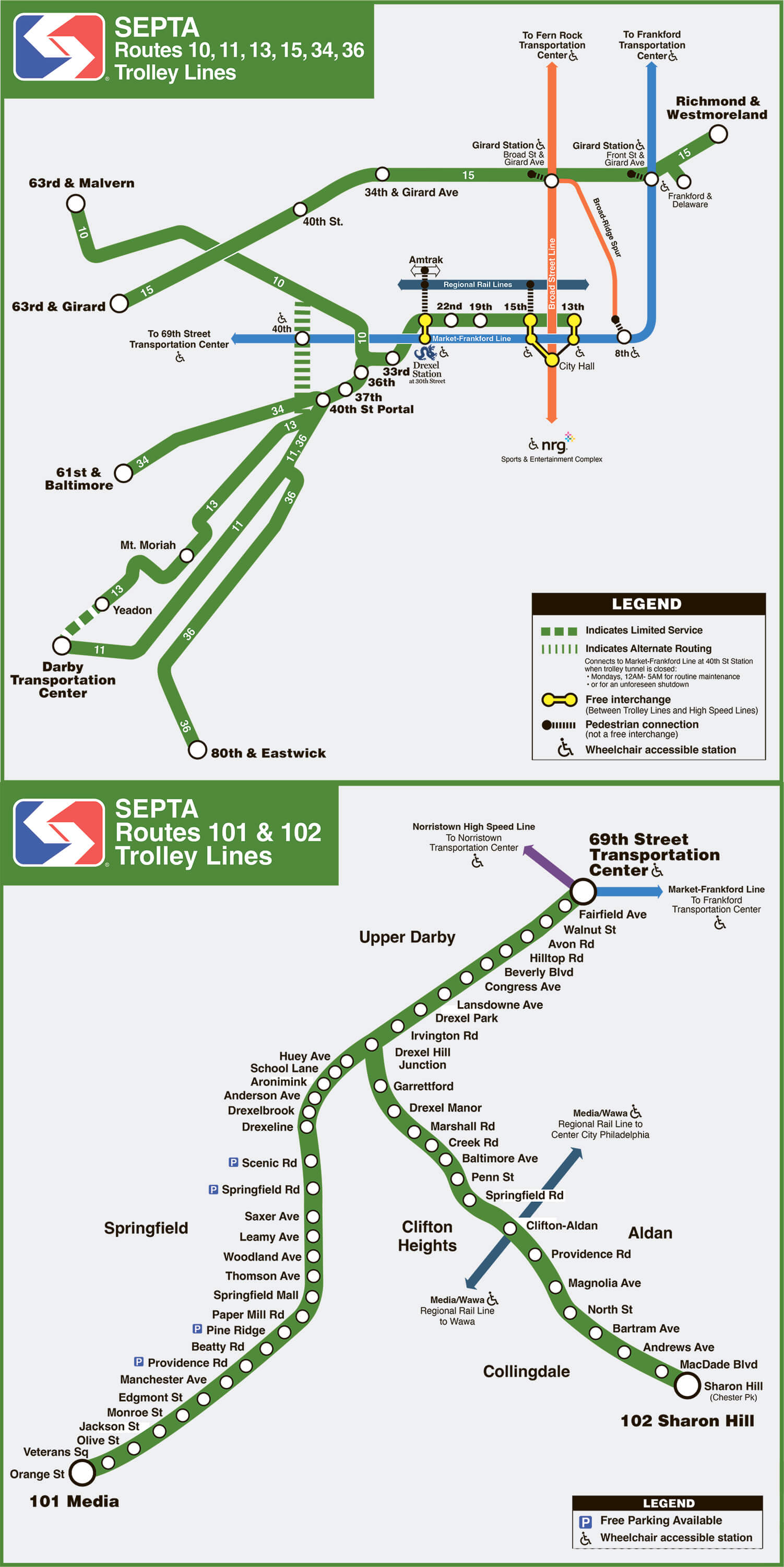
SEPTA Subway-Surface Trolleys Map
SEPTA Subway-Surface Trolleys map shows all available lines and stations. Click on the map to enlarge it or download the SEPTA Subway-Surface Trolleys map in PDF format.
Lines and Stations
The T system has five branches arranged from north to south. All five routes share the Center City tunnel, then split west of the tunnel portals onto Lancaster, Baltimore, Chester, Woodland, and Elmwood avenues.
| Station | Details |
|---|---|
| 13th St | Eastern terminal for the five T routes during normal service; transfer to the L |
| 15th St / City Hall | Transfer point for the L and B; first and last stop when 13th St is not served overnight |
| 19th St | Center City tunnel station served by all T routes |
| 22nd St | Center City tunnel station served by all T routes |
| Drexel Station at 30th St | Transfer area for the L, SEPTA Regional Rail, Amtrak, and NJ Transit connections nearby |
| 33rd St | Shared tunnel station near Drexel University |
| 36th St Portal | Portal used by T1 / Route 10 |
| 40th St Portal | Portal used by T2, T3, T4, and T5; also important during diversions |
The basic route plan is simple: eastbound trains run toward 13th St, while westbound trains continue to different terminals. Check the current stations map and train schedule before traveling, especially if tunnel work or late-night diversions are in effect.
| Station | Details |
|---|---|
| T1 / Route 10 | Lancaster Avenue service to 63rd-Malvern / Overbrook |
| T2 / Route 34 | Baltimore Avenue service to 61st-Baltimore / Angora |
| T3 / Route 13 | Chester Avenue service to Yeadon and Darby Transit Center |
| T4 / Route 11 | Woodland Avenue service to Darby Transit Center |
| T5 / Route 36 | Elmwood Avenue service to 80th St / Eastwick |
Shared Tunnel Stations in Center City and University City
All five T routes use the same underground corridor in Center City before branching west of the Schuylkill River. The shared tunnel makes short downtown trips easy, and it also gives riders several transfer points to SEPTA city transport, Regional Rail, and intercity trains.
| Station | Details |
|---|---|
| 13th St | Normal eastern terminal for all T routes and transfer point to the L |
| 15th St / City Hall | Transfer to the L and B; connects toward Suburban Station |
| 19th St | Center City stop served by all T routes |
| 22nd St | Center City stop served by all T routes |
| Drexel Station at 30th St | Major connection area for 30th Street Station, Regional Rail, Amtrak, and the L |
| 33rd St | Shared station near Drexel University |
| 36th-Sansom | University of Pennsylvania campus stop used by T2, T3, T4, and T5 before the 40th St Portal |
| 37th-Spruce | University of Pennsylvania campus stop used by T2, T3, T4, and T5 before the 40th St Portal |
T1 leaves the tunnel at the 36th St Portal. T2, T3, T4, and T5 continue to the 40th St Portal. When the tunnel is closed, all five routes can use surface diversion tracks, and riders may need to connect to the L for Center City service.
T1 / Route 10 — Lancaster Avenue
T1, formerly Route 10, is the Lancaster Avenue branch. It runs between 13th St in Center City and 63rd-Malvern / Overbrook in West Philadelphia.
From 13th St, T1 serves the shared Market Street tunnel stations at 15th St, 19th St, 22nd St, 30th St, and 33rd St. Free transfers are available to the L at 13th, 15th, and 30th streets, and to the B at 15th St / City Hall.
Unlike the other T routes, T1 exits at the 36th St Portal. It then runs north on 36th Street and northwest along Lancaster Avenue toward 63rd Street and the Malvern Loop. A wye cutback at Lancaster Avenue and a diversion track at 40th Street can be used when the tunnel is closed.
| Station | Details |
|---|---|
| Eastbound terminal | 13th St |
| Westbound terminal | 63rd-Malvern / Overbrook |
| Surface corridor | Lancaster Avenue |
| Portal | 36th St Portal |
T2 / Route 34 — Baltimore Avenue
T2, formerly Route 34, is the Baltimore Avenue branch between 13th St and 61st-Baltimore / Angora. It is about 10.1 miles (16.3 km) long and uses 600 V DC overhead line electrification.
The route runs through the Market Street tunnel, serving 15th St, 19th St, 22nd St, 30th St, and 33rd St before surfacing at the 40th St Portal near Baltimore Avenue. From there, it continues west to its Angora terminal.
Route 34 entered the subway-surface tunnel on December 15, 1906. It was once known as the Angora Line, became Route 34 in 1911, resumed service after a COVID-19 suspension on May 17, 2020, and is now branded as T2.
| Station | Details |
|---|---|
| Eastbound terminal | 13th St |
| Westbound terminal | 61st-Baltimore / Angora |
| Surface corridor | Baltimore Avenue |
| Portal | 40th St Portal |
T3 / Route 13 — Chester Avenue
T3, formerly Route 13, runs from 13th St in downtown Philadelphia to Yeadon and, on limited service, Darby Transit Center. It is the Chester Avenue branch of the SEPTA Metro T system.
The line uses the shared tunnel under Market Street, then surfaces at the 40th St Portal. It runs southwest, uses Woodland Avenue briefly, then turns onto Chester Avenue. During tunnel closures, an alternate alignment along 42nd Street may be used.
West of Center City, the route crosses the Media/Wawa Line at 49th Street, passes the area near Mt. Moriah Cemetery, and continues through Kingsessing Avenue, 65th Street, Cobbs Creek Parkway, and Chester Avenue. The line is 11.4 miles (18.3 km) long, uses Pennsylvania trolley gauge, and is based at Elmwood Carhouse.
| Station | Details |
|---|---|
| Eastbound terminal | 13th St |
| Westbound terminals | Yeadon and Darby Transit Center |
| Surface corridor | Chester Avenue |
| Stations and stops | 8 underground stations, 1 surface-level station, and 39 street-level stops |
| Line length | 11.4 miles (18.3 km) |
| Average weekday ridership | 13,364 in 2019 |
T4 / Route 11 — Woodland Avenue
T4, formerly Route 11, is the Woodland Avenue line. It links 13th St in Center City with Darby Transit Center, serving West Philadelphia and Delaware County along the way.
After the shared tunnel stations, T4 surfaces at the 40th St Portal and continues southwest along Woodland Avenue. It shares part of the corridor with T5 before T5 splits near 49th Street, while T4 continues toward Darby.
The line has deep roots in Philadelphia tramway history. It began in 1858 as part of the West Philadelphia Passenger Railway Company, was extended east in 1896, entered the subway-surface system in 1906, and later became T4 under SEPTA Metro branding.
| Station | Details |
|---|---|
| Eastbound terminal | 13th St |
| Westbound terminal | Darby Transit Center |
| Surface corridor | Woodland Avenue |
| Portal | 40th St Portal |
T5 / Route 36 — Elmwood Avenue
T5, formerly Route 36, is the Elmwood Avenue branch and the southernmost T line. It runs from 13th St to 80th St / Eastwick, with limited service to Elmwood Carhouse.
The line uses the shared tunnel under Market Street and then surfaces west of University City. It reaches Elmwood Avenue near the area where Lindbergh Boulevard becomes a divided highway east of 56th Street, crosses over the Airport Line, and continues toward Eastwick.
T5 is associated with Southwest Philadelphia and the industrial area near Elmwood Avenue, Island Road, and Passyunk Avenue, close to Elmwood Depot.
| Station | Details |
|---|---|
| Eastbound terminal | 13th St |
| Westbound terminal | 80th St / Eastwick |
| Surface corridor | Elmwood Avenue |
| Portal | 40th St Portal |
Schedule, Frequency, and Service Patterns
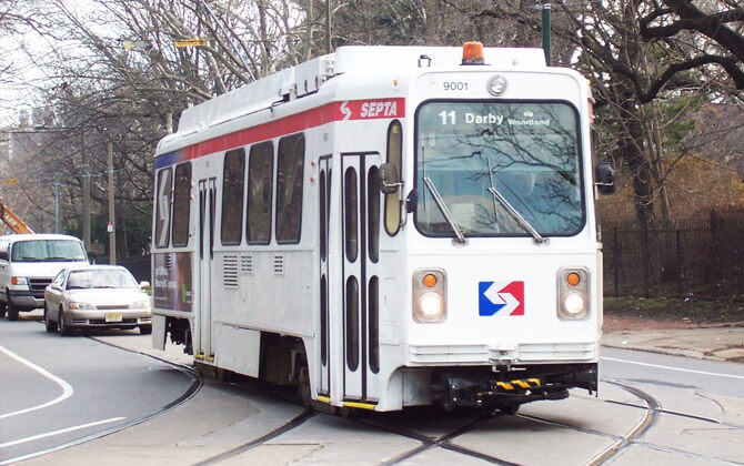
The T schedule is built around the shared trunk tunnel and five westbound branches. Operating hours, opening times, working hours, frequency, and closing time can vary by route, day, and service disruption, so riders should check the route timetable or schedule today before starting a trip.
| Service detail | Timings |
|---|---|
| Trunk starting time and closing time | About 5:00 am to midnight in the published service table |
| Trunk frequency | Less than 8 minutes in the morning, less than 3 minutes during morning rush, less than 5 minutes midday, less than 4 minutes during evening rush, and less than 8 minutes in the evening |
| Route 10 / T1 frequency | About 20 minutes morning, 7 minutes morning rush, 10 minutes midday, 5 minutes evening rush, 15 minutes evening, 35 minutes overnight, 15 minutes Saturday, and 20 minutes Sunday |
| Route 11 / T4 opening hours in table | 4:29 am to 2:02 am; no overnight service shown in the frequency table |
| Route 13 / T3 frequency | About 13 minutes morning, 5 minutes rush periods, 10 minutes midday, 15 minutes evening, 35 minutes overnight, 15 minutes Saturday, and 20 minutes Sunday |
| Route 34 / T2 opening hours in table | 4:57 am to 1:45 am; no overnight service shown in the frequency table |
| Route 36 / T5 frequency | About 12 minutes morning, 6 minutes morning rush, 10 minutes midday, 5 minutes evening rush, 15 minutes evening, 32 minutes overnight, 15 minutes Saturday, and 20 minutes Sunday |
| Shared tunnel running time | About 10 minutes in the published table |
| Branch trip times | About 25 to 40 minutes for most T branches in the published table |
| 13th St overnight change | 13th St is not served between 12:30 am and 5:00 am; 15th St / City Hall becomes the first and last stop |
| Sunday night diversion | Every Sunday night from 10:00 pm to 5:00 am, trolleys may be diverted to 40th and Market for connection to the L or late-night MFL Owl buses |
For best results, check timings today in SEPTA real-time tools or the Transit app. Tunnel work, accidents, special events, and overnight changes can alter the route timetable with little notice.
Weekday, Weekend, and Evening Service
Weekday daytime service is the most frequent, especially in the shared tunnel. Weekend and evening service still runs at regular intervals, but the gaps between trains are usually longer.
The five T routes are 10, 34, 13, 11, and 36. Route 15 belongs to the wider trolley network, but it is not part of the subway-surface T system described here.
| Service detail | Timings |
|---|---|
| Weekday trunk frequency | As frequent as less than 3 minutes during morning rush and less than 4 minutes during evening rush |
| Saturday branch frequency | About 15 minutes on listed T branches |
| Sunday branch frequency | About 20 minutes on listed T branches |
| Evening frequency | About 15 minutes on listed branches |
| Late-night 13th St change | 13th St not served from 12:30 am to 5:00 am |
Overnight Service and Late-Night Changes
Overnight service is more limited and can be affected by tunnel closures. The source material notes that T2 and T4 do not have overnight service, while overnight frequency is shown for Route 10, Route 13, and Route 36.
On certain late-night event dates, all five trolley routes may run in the tunnel overnight. On the following Tuesday nights listed in the service notice, service is diverted to 40th and Market from 10:00 pm until 5:00 am, and riders should connect to the L for Center City travel.
| Service detail | Timings |
|---|---|
| Route 10 overnight frequency | About 35 minutes |
| Route 13 overnight frequency | About 35 minutes |
| Route 36 overnight frequency | About 32 minutes |
| 13th St overnight status | Closed to trolley service from 12:30 am to 5:00 am |
| Diversion connection | Use the L at 40th Street, or MFL Owl buses after midnight when directed |
Fares, Tickets, and Payment Methods
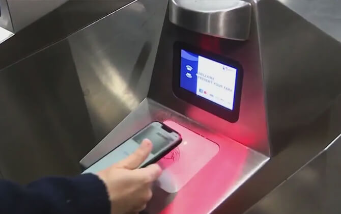
The T uses SEPTA’s standard City Transit fare. The base ticket price is $2.90 USD per trip. Riders can pay with a contactless card or mobile wallet, a SEPTA Key card, cash, or a Quick Trip where available.
Contactless payment and SEPTA Key Travel Wallet include up to two free transfers within 2 hours when the same card or device is used. Cash and Quick Trip riders do not receive free transfers. Children under 12 ride free with a fare-paying adult, and seniors over 65 ride free with a valid Senior Fare Card.
| Service detail | Timings |
|---|---|
| Base fare | $2.90 USD per trip |
| SEPTA Key card cost | $4.95 USD |
| Transfer window | 2 hours from first tap for eligible payment types |
| Key Tix validity after activation | 2 hours |
Contactless Payment
SEPTA accepts contactless credit and debit cards, plus mobile wallets such as Apple Pay, Google Pay, and Samsung Pay. On Metro and bus service, tap the reader and board. Use the same card or device for transfers so the system can apply the correct fare.
Contactless payment can cover up to five riders traveling together on one card or device. Each tap is charged as a full fare. SEPTA also advises separating payment cards and phones before tapping to avoid card clash.
For Regional Rail, contactless rules are different: riders tap on and tap off at faregates or platform validators where required, and transfers are not included.
SEPTA Key Card and Passes
The SEPTA Key Card is a reloadable contactless card that can store Travel Wallet funds and pass products, including Daily, Weekly, and Monthly Passes. The card costs $4.95 USD, and the fee is refunded to Travel Wallet when the card is registered within 30 days, with limits per account.
You can buy and reload a Key card at fare kiosks, select retail locations, septakey.org, or through the SEPTA App. Registration also lets you check balances, review trip history, set auto-load, and report a lost or stolen card.
Weekly Passes include up to 56 trips and are valid from 12:01 am Monday until 2:00 am the following Monday. Monthly Passes include up to 240 trips and are valid from 12:01 am on the first day of the month until 2:00 am on the first day of the following month.
SEPTA Key cards are valid for up to four years from the purchase date shown on the card. If a card is expiring, buy and register a new one before moving remaining eligible fares.
Connections with Other SEPTA Services
The T connects with the L, B, Regional Rail, Amtrak, NJ Transit, bus routes, LUCY, and suburban transit links. These transfers make the subway-surface system useful for local transport as well as longer trips across the region.
| Station | Details |
|---|---|
| 13th St | Transfer to the L |
| 15th St / City Hall | Transfer to the L and B; access toward Regional Rail via Suburban Station |
| 30th St | Transfer area for the L, SEPTA Regional Rail, Amtrak, and NJ Transit Atlantic City Line connections |
| 40th St | Diversion connection point to the L when the trolley tunnel is closed |
Market-Frankford Line Connections
The Market-Frankford Line, branded as the L, is the most important rapid transit connection for T riders. Free transfers are available at 13th St, 15th St, and 30th St.
Between 15th and 30th streets, the L and T use the same tunnel corridor, with the L on the inner tracks and the trolleys on the outer tracks. During diversions, 40th Street becomes the key connection point for continuing to or from Center City.
Broad Street Line Connections
The T connects with the Broad Street Line, branded as the B, at 15th St / City Hall. This is one of the most useful transfer points for trips north and south through Philadelphia.
At the same station area, riders can also transfer to the L and reach Regional Rail through passages toward Suburban Station.
Regional Rail, Amtrak, and 30th Street Connections
Regional Rail connections are available through the underground passages linking 13th and 15th street stations with Suburban Station. At 30th Street Station, riders can connect with SEPTA Regional Rail, many Amtrak services, and NJ Transit’s Atlantic City Line.
The old underground passage between the trolley and rapid transit station and 30th Street Station closed in the 1980s due to safety concerns. Today, riders walk outside and cross 30th Street to reach the main station building.
Bus, LUCY, and Suburban Transit Connections
Bus and LUCY service add useful links around University City, West Philadelphia, and 30th Street Station. LUCY is the Loop through University City, serving the campus area and 30th Street Station.
In the Penn and West Philadelphia area, the source material lists bus connections including Bus 30, Bus 31, Bus 40, Bus 42, and Bus 21. During tunnel diversions, riders may also board or exit at bus stops along the diversion route.
Connections to Philadelphia International Airport
The Subway-Surface Trolleys do not go directly to Philadelphia International Airport. The most direct rail route is SEPTA’s Airport Line, part of Regional Rail.
The Airport Line runs from Center City to the airport every day, with trains about every 30 minutes from around 5:00 am to midnight. The ride from Suburban Station to the airport takes about 19 to 24 minutes.
The Airport Line serves Terminal A, Terminal B, Terminals C & D, and Terminals E & F. Each airport station connects to terminal buildings by escalators and elevators and has high-level platforms.
From the T, use Center City transfer points to reach Regional Rail. The easiest options are Suburban Station via 13th or 15th streets, or 30th Street Station. SEPTA bus routes 37 and 108 also serve the airport area from other parts of the network.
How to Ride the Subway-Surface Trolleys
Riding the T is straightforward once you know where the routes split. In Center City and University City, all T routes serve the shared stations between 13th St and 33rd St. West of 33rd St, the path train takes depends on its branch.
From 33rd St, take any eastbound trolley for Center City. From Center City, choose the westbound route that matches your destination: T1 for Lancaster Avenue, T2 for Baltimore Avenue, T3 for Chester Avenue, T4 for Woodland Avenue, or T5 for Elmwood Avenue.
| Station | Details |
|---|---|
| 13th St | Normal eastern end for all five routes |
| 33rd St | Last shared stop before T1 separates toward the 36th St Portal |
| 36th St Portal | T1 leaves the tunnel here |
| 40th St Portal | T2, T3, T4, and T5 leave the tunnel here |
When your stop is next, pull the yellow cord above the windows or press the black button near the rear door. If exiting at the rear, step down carefully; the top step acts as a pressure plate that opens the door.
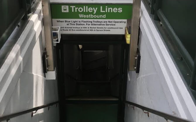
During tunnel closures, all five routes can divert to surface tracks west of the 40th St Portal. If that happens, connect to the L at 40th Street for travel to and from Center City.
Tips for Tourists
The T is useful for visitors moving between Center City, University City, West Philadelphia, and Delaware County. It saves time downtown because it runs underground, then gives neighborhood-level access once it reaches the surface.
A SEPTA Key Card or contactless payment is usually the easiest way to pay. Cash is accepted where allowed, but exact fare is required and transfers are not included.
Before you go, check the current schedule, stations map, and service alerts. This matters at night, during special events, and whenever SEPTA is using a diversion route.
Keep your belongings close, watch station signs, and allow a little extra time for transfers. The system is safe to use with normal city travel awareness, especially in busy Center City and University City stations.
Accessibility, Bikes, Strollers, and Rider Rules
SEPTA supports riders with different mobility needs, but the current subway-surface trolley fleet has limits. SEPTA buses are ADA accessible, and certain subway, elevated, and Regional Rail stations are ADA accessible. SEPTA is working to modernize trolleys and make them ADA accessible.
Open strollers are not permitted on subway-surface trolleys due to accessibility constraints. Priority seating must be cleared when a person with a disability needs to board and ride.
Non-folding personal vehicles are not allowed on subway-surface trolleys. Folding bikes and folding scooters are permitted only when fully collapsed. Riders should keep aisles and doors clear, follow crew instructions, walk personal vehicles in stations, and avoid charging devices on SEPTA vehicles or property.
Service animals may ride on SEPTA. Groups of bicyclists planning to ride together should submit a Group Travel Request at least five days in advance.
Brief History and SEPTA Metro Rebrand
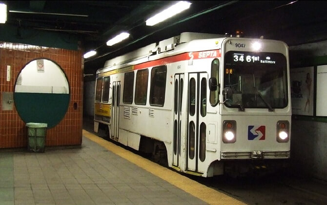
The T is a remnant of Philadelphia’s much larger streetcar and tramway network. Electric trolleys arrived in 1892, and in 1902 several traction companies were consolidated into the Philadelphia Rapid Transit Company.
Passenger service in the subway-surface tunnel opened on December 15, 1906. After the PRT declared bankruptcy in 1939, the system continued under the Philadelphia Transportation Company, which SEPTA later absorbed in 1968.
The routes have long served West Philadelphia, including trips to the University of Pennsylvania and Center City. Some patterns changed over time, including the burial of a trolley route in 1956 to help unify the Penn campus.
In 2021, SEPTA proposed rebranding its rail services as SEPTA Metro to make the system easier to navigate. The subway-surface lines became the T, with a green color and numeric suffixes. Former routes 10, 34, 13, 11, and 36 became T1, T2, T3, T4, and T5, with new station and line names taking effect systemwide on February 23–24, 2025.
Modernization and Future Improvements
SEPTA’s Trolley Modernization program is intended to make the region’s trolley network more accessible, faster, and easier to use. The work includes the Center City tunnel, subway-surface lines, Route 15, and the Media-Sharon Hill lines.
The program aims to improve transit access, support more than 38,000 permanent jobs, reduce pollution, and strengthen neighborhood connections. Planning is nearing completion, design is underway, and construction is expected from 2024 through 2030.
SEPTA expects new trolley vehicles to be in service on all modernized lines by 2031, with some lines opening earlier. The first construction priorities are the T Lines, followed by the D Lines and then the G Line.
The new vehicles are planned to have low floors, ramps, wider pathways, open space for wheelchairs, walkers, strollers, and bicycles, plus audio and visual information systems. Stations will also be rebuilt or upgraded with ADA-compliant features such as ramps, elevators, higher and longer platforms, better signage, lighting, shelters, and safer waiting areas.
During construction, trolley service will be interrupted at times, and SEPTA plans to provide bus service as an alternative when routes are out of service.
Nearby Attractions and Neighborhoods
The T connects Center City with University City, West Philadelphia, Southwest Philadelphia, and Delaware County. It is useful for reaching City Hall, Dilworth Park, 30th Street Station, Drexel University, the University of Pennsylvania, Overbrook, Angora, Yeadon, Darby, and Eastwick.
| Station | Details |
|---|---|
| 13th St | City Hall area and Center City access |
| 15th St / City Hall | Dilworth Park, City Hall, and transfers to the L and B |
| Drexel Station at 30th St | 30th Street Station, Amtrak, Regional Rail, and University City access |
| 33rd St | Drexel University area |
| 36th-Sansom and 37th-Spruce | University of Pennsylvania area on T2, T3, T4, and T5 |
| Darby Transit Center | Served by T4 and some T3 trips |
| 80th St / Eastwick | Western end of T5 |
Center City and City Hall Area
In Center City, the T runs underground around City Hall and beneath Market Street. The key stations are 13th St, 15th St / City Hall, 19th St, 22nd St, Drexel Station at 30th St, and 33rd St.
Between 12:30 am and 5:00 am, 13th St is not served, so 15th St / City Hall becomes the first and last stop. On some overnight closures, riders are sent to 40th Street for the L connection.
University City, Drexel, and Penn Area
The T is especially useful in University City. It serves 30th Street Station, continues to 33rd St near Drexel University, and then splits.
T1 leaves at the 36th St Portal for Lancaster Avenue. T2, T3, T4, and T5 continue to 36th-Sansom and 37th-Spruce near the Penn campus before surfacing at the 40th St Portal.
| Station | Details |
|---|---|
| 30th St | Regional Rail, Amtrak, NJ Transit Atlantic City Line, and L connections nearby |
| 33rd St | Drexel University access |
| 36th-Sansom | Penn campus area |
| 37th-Spruce | Penn campus area |
West Philadelphia Neighborhood Corridors
West of the shared tunnel, the T becomes a street-running trolley system. The branches follow major neighborhood corridors across West and Southwest Philadelphia.
| Station | Details |
|---|---|
| Lancaster Avenue | T1 / Route 10 toward 63rd-Malvern / Overbrook |
| Baltimore Avenue | T2 / Route 34 toward 61st-Baltimore / Angora |
| Chester Avenue | T3 / Route 13 toward Yeadon and Darby Transit Center |
| Woodland Avenue | T4 / Route 11 toward Darby Transit Center |
| Elmwood Avenue | T5 / Route 36 toward 80th St / Eastwick |
Darby, Eastwick, and Southwest Philadelphia Destinations
T3, T4, and T5 continue toward Southwest Philadelphia and Delaware County destinations. T3 serves Yeadon and some trips to Darby Transit Center, T4 runs to Darby Transit Center, and T5 continues to Eastwick.
| Station | Details |
|---|---|
| Yeadon | Served by T3 / Route 13 |
| Darby Transit Center | Served by T4 / Route 11 and some T3 / Route 13 trips |
| 80th St / Eastwick | Served by T5 / Route 36 |
Night service and tunnel diversions can change the path, so check the current route plan before traveling to Darby, Eastwick, or nearby Southwest Philadelphia neighborhoods.
FAQ
Is the SEPTA Subway-Surface Trolley a subway or a trolley?
It is both in practical terms. The T runs like a trolley on surface streets in West Philadelphia and Delaware County, and it runs underground beneath Market Street in Center City. That is why the system was historically called the Subway-Surface Trolleys.
Which routes are included in the SEPTA T system?
The T system includes five routes: T1 / Route 10, T2 / Route 34, T3 / Route 13, T4 / Route 11, and T5 / Route 36. Route 15 is not part of the subway-surface T system.
Do all T routes use the same tunnel?
Yes. All five T routes share the Center City tunnel from 13th St through the Market Street corridor. T1 exits at the 36th St Portal, while T2, T3, T4, and T5 continue to the 40th St Portal.
How do I pay for a ride?
You can pay the $2.90 USD fare with a contactless credit or debit card, a mobile wallet, a SEPTA Key card, cash, or a Quick Trip where available. SEPTA Key and contactless payment include eligible free transfers within 2 hours when the same card or device is used.
Does the trolley connect to Philadelphia International Airport?
No. The T does not serve Philadelphia International Airport directly. Use SEPTA Regional Rail’s Airport Line from Center City, with transfer options from the T at Suburban Station or 30th Street Station.
Are the trolleys accessible?
The current Kawasaki trolleys are not fully ADA-compliant because they have high floors and internal steps. SEPTA’s Trolley Modernization program is planned to bring low-floor accessible vehicles, ramps, wider interiors, and accessible stations.
What should I do during tunnel diversions?
When the trolley tunnel is closed, T routes can divert to surface tracks west of the 40th St Portal. Use the L at 40th Street for travel to and from Center City, and follow posted service alerts for the current schedule today and last train information.