Houston METRO Rail, also called METRORail, is the light rail system serving Houston, Texas, as part of the Metropolitan Transit Authority of Harris County. The system has three lines: the Red Line, Green Line, and Purple Line. Together they cover 22.7 miles (36.5 km), serve 39 stations, and connect key city transport destinations such as Downtown Houston, the Texas Medical Center, the Museum District, NRG Park, the University of Houston, Texas Southern University, and the Theater District.
| Key | Information |
|---|---|
| System | Houston METRO Rail, a light rail network operated by METRO |
| Lines | Red Line, Green Line, Purple Line |
| Network length | 22.7 miles (36.5 km) |
| Stations | 39 stations across the current system |
| Opening date | January 1, 2004 |
| Typical frequency | Red Line every 6 minutes on weekdays; Green and Purple lines every 12 minutes on weekdays during most operating hours |
| Regular fare | US$1.25 ($1.25) |
| Main payment options | RideMETRO Fare Card, RideMETRO app, contactless cards, mobile wallets, 3-Hour Pass, and Day Pass |
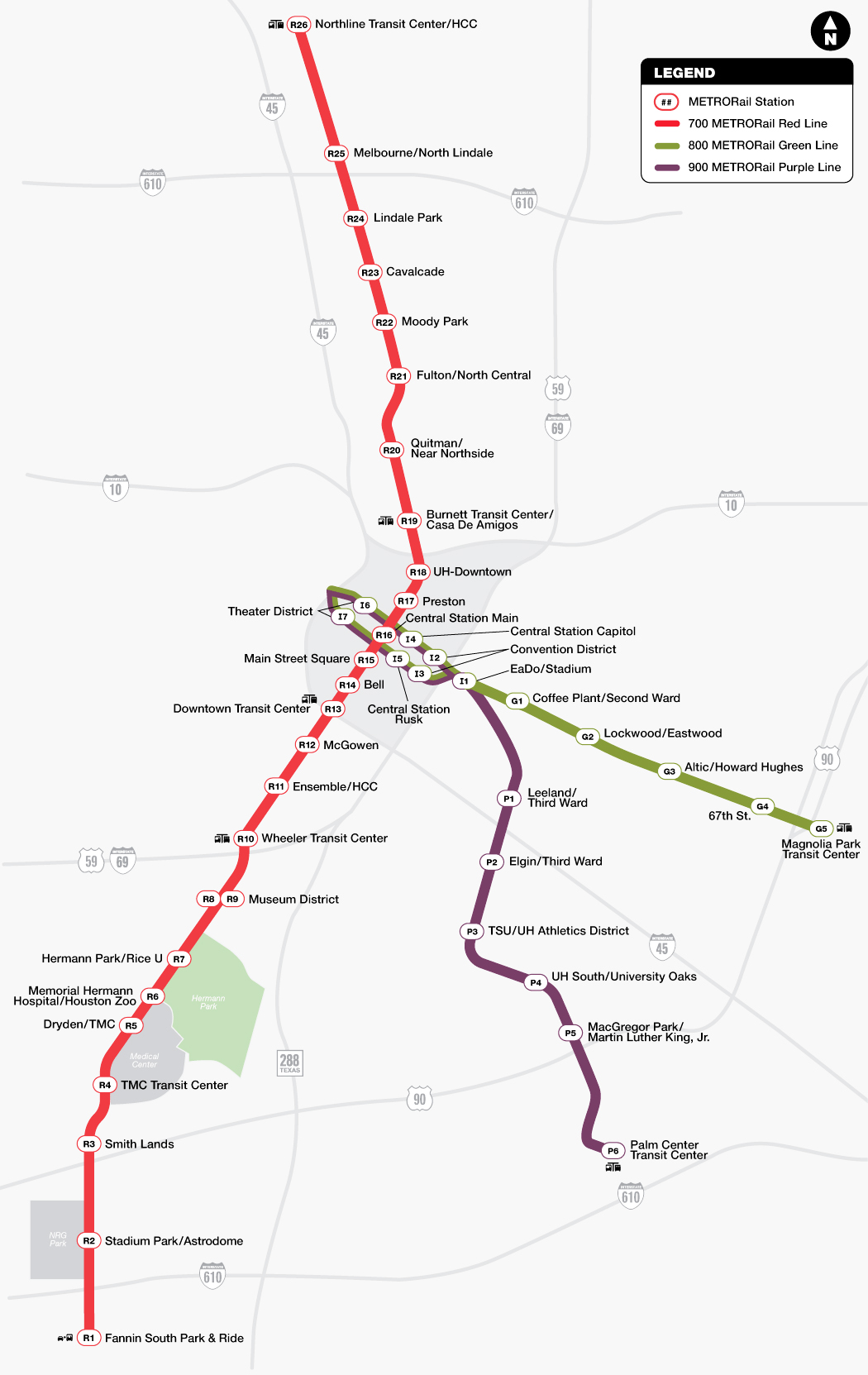
Houston METRO Rail Map
Houston METRO Rail Map showing 3 lines and different stations. Click on the map to enlarge it or download the Houston METRO Rail map in PDF format.
Lines and Stations
METRORail has three active light rail routes and a stations list that covers Downtown Houston, Midtown, the Museum District, the Texas Medical Center, the East End, Third Ward, and Southeast Houston. If you are checking a stations map or building a route plan, Central Station is the main downtown transfer point between the rail lines.
The Red Line opened first on January 1, 2004, from Fannin South to UH-Downtown. It was later extended north to Northline Transit Center/HCC on December 21, 2013. The Green and Purple lines opened on May 23, 2015, and the Green Line was extended to Magnolia Park Transit Center on January 11, 2017.
Only two METRORail stations have public park-and-ride lots: Burnett Transit Center and Fannin South. Both charge US$3 ($3) per day. METRO has also proposed 26 additional stations for the University and Uptown lines in western Houston.
| Station | Details |
|---|---|
| Altic/Howard Hughes | Green Line; Second Ward; opened May 23, 2015 |
| Bell | Red Line; Downtown Houston; opened January 1, 2004 |
| Burnett Transit Center/Casa de Amigos | Red Line; Downtown Houston; opened December 21, 2013; public station parking available for a daily fee |
| Cavalcade | Red Line; Near Northside; opened December 21, 2013 |
| Central Station | Red, Green, and Purple lines; Downtown Houston; opened February 18, 2015 for Red Line service |
| Cesar Chavez/67th Street | Green Line; Magnolia Park; opened January 11, 2017 |
| Coffee Plant/Second Ward | Green Line; Second Ward; opened May 23, 2015 |
| Convention District | Green and Purple lines; Downtown Houston; opened May 23, 2015 |
| Downtown Transit Center | Red Line; Downtown Houston; opened January 1, 2004 |
| Dryden/TMC | Red Line; Texas Medical Center; opened January 1, 2004 |
| EaDo/Stadium | Green and Purple lines; East Downtown; opened May 23, 2015 |
| Elgin/Third Ward | Purple Line; Third Ward; opened May 23, 2015 |
| Ensemble/HCC | Red Line; Midtown; opened January 1, 2004 |
| Fannin South | Red Line; Southeast Houston; opened January 1, 2004; public station parking available for a daily fee |
| Fulton/North Central | Red Line; Near Northside; opened December 21, 2013 |
| Hermann Park/Rice University | Red Line; Museum District; opened January 1, 2004 |
| Leeland/Third Ward | Purple Line; East Downtown; opened May 23, 2015 |
| Lindale Park | Red Line; Northside; opened December 21, 2013 |
| Lockwood/Eastwood | Green Line; Second Ward; opened May 23, 2015 |
| MacGregor Park/Martin Luther King Jr. | Purple Line; Southeast Houston; opened May 23, 2015 |
| Magnolia Park Transit Center | Green Line; Magnolia Park; opened January 11, 2017 |
| Main Street Square | Red Line; Downtown Houston; opened January 1, 2004 |
| McGowen | Red Line; Midtown; opened January 1, 2004 |
| Melbourne/North Lindale | Red Line; Northside; opened December 21, 2013 |
| Memorial Hermann Hospital/Houston Zoo | Red Line; Texas Medical Center; opened January 1, 2004 |
| Moody Park | Red Line; Near Northside; opened December 21, 2013 |
| Museum District | Red Line; Museum District; opened January 1, 2004 |
| Northline Transit Center/HCC | Red Line; Northside; opened December 21, 2013 |
| Palm Center Transit Center | Purple Line; Southeast Houston; opened May 23, 2015 |
| Preston | Red Line; Downtown Houston; opened January 1, 2004 |
| Quitman/Near Northside | Red Line; Near Northside; opened December 21, 2013 |
| Smith Lands | Red Line; Texas Medical Center; opened January 1, 2004 |
| Stadium Park/Astrodome | Red Line; NRG Park; opened January 1, 2004 |
| Texas Medical Center Transit Center | Red Line; Texas Medical Center; opened January 1, 2004 |
| Theater District | Green and Purple lines; Houston Theater District; opened May 23, 2015 |
| TSU/UH Athletics District | Purple Line; Third Ward; opened May 23, 2015 |
| UH South/University Oaks | Purple Line; Third Ward; opened May 23, 2015 |
| UH-Downtown | Red Line; Downtown Houston; opened January 1, 2004 |
| Wheeler | Red Line; Midtown; opened January 1, 2004 |
Planned expansion stations for the University and Uptown lines would add service in western Houston. Existing stations that would become transfer points with the University Line include Wheeler on the Red Line and Elgin/Third Ward on the Purple Line.
| Station | Details |
|---|---|
| Almeda | Planned University Line station in the Houston Museum District |
| Ambassador Way | Planned Uptown Line station in Uptown Houston |
| Bellaire | Planned University and Uptown lines station in Bellaire |
| Cullen | Planned University Line station in Third Ward |
| Cummins | Planned University Line station in Upper Kirby |
| Eastwood Transit Center | Planned University Line station in Eastwood |
| Edloe | Planned University Line station in Upper Kirby |
| Four Oaks | Planned Uptown Line station in Uptown Houston |
| Gulfton | Planned University Line station in Gulfton |
| Hillcroft Transit Center | Planned University Line station in Sharpstown |
| Hutchins | Planned University Line station in Third Ward |
| Kirby | Planned University Line station in Upper Kirby |
| Memorial | Planned Uptown Line station near Memorial Park |
| Menil | Planned University Line station in Montrose |
| Montrose | Planned University Line station in Montrose |
| Newcastle | Planned University Line station in West University Place |
| Northwest Transit Center | Planned Uptown Line station in Spring Branch |
| Richmond | Planned Uptown Line station in Uptown Houston |
| San Felipe | Planned Uptown Line station in Uptown Houston |
| Shepherd | Planned University Line station in Upper Kirby |
| Tierwester | Planned University Line station in Third Ward |
| TSU | Planned University Line station in Third Ward |
| Uptown Park | Planned Uptown Line station in Uptown Houston |
| Weslayan | Planned University Line station in West University Place |
| West Alabama | Planned Uptown Line station in Uptown Houston |
| Westheimer | Planned Uptown Line station in Uptown Houston |
Red Line
The Red Line is Houston METRO Rail’s original and busiest north-south light rail route. It runs from Fannin South to Northline Transit Center/HCC, serving Downtown Houston, Midtown, the Museum District, the Texas Medical Center, UH-Downtown, and NRG Park.
The line opened on January 1, 2004 as the original Main Street Line and was later extended north. It is 12.6 miles (20.3 km) long, double-tracked, and has 24 stations. Most of the route runs at street level in dedicated lanes with signal priority at intersections.
| Station | Details |
|---|---|
| Northline Transit Center/HCC | Northern Red Line terminal and transit center connection |
| Burnett Transit Center/Casa de Amigos | Transit center connection with public parking |
| Downtown Transit Center | Downtown transfer point for local transport and bus routes |
| Central Station | Downtown connection with the Green and Purple lines and multiple bus routes |
| Convention District | Nearby connection area for Green and Purple Line service |
| Fannin South | Southern Red Line terminal with paid station parking |
Red Line destination signs may show Northline TC/HCC, Smith Lands, or Fannin South. During most working hours, trains run every 6 minutes on weekdays and every 12 minutes on weekends.
Green Line
The Green Line is METRORail’s East End route, running from downtown Houston to Magnolia Park Transit Center. It shares a downtown segment with the Purple Line between Theater District and EaDo/Stadium, then continues east through the historic East End.
The first segment opened on May 23, 2015, and the final two stations opened on January 11, 2017. Green Line trains usually display Magnolia Park or Theater District as the destination.
| Station | Details |
|---|---|
| Theater District | Downtown western end of Green Line service |
| Central Station | Downtown transfer point for rail lines and bus connections |
| Convention District | Useful for downtown events and convention access |
| EaDo/Stadium | Shared Green and Purple Line station in East Downtown |
| Coffee Plant/Second Ward | East End station with local bus connections |
| Lockwood/Eastwood | East End station served by the Green Line |
| Altic/Howard Hughes | Green Line station in Second Ward |
| Cesar Chavez/67th Street | Green Line station in Magnolia Park |
| Magnolia Park Transit Center | Eastern Green Line terminal with bus connections |
Green Line frequency is every 12 minutes Monday through Friday and every 18 minutes on Saturday and Sunday for most operating hours. Exact timings can vary, so check the train schedule if you have a tight connection.
Purple Line
The Purple Line links Downtown Houston with Southeast Houston and Palm Center. It is especially useful for trips to the University of Houston, Texas Southern University, Third Ward, the Convention District, and the Theater District.
The line opened on May 23, 2015 and is about 6.6 miles (10.6 km) long. Purple Line trains display Palm Center TC or Theater District as the destination.
| Station | Details |
|---|---|
| Theater District | Downtown stop shared with the Green Line |
| Central Station | Connection point for Red, Green, and Purple Line trips |
| Convention District | Downtown event and convention access |
| EaDo/Stadium | East Downtown station shared with the Green Line |
| Leeland/Third Ward | Purple Line station near East Downtown and Third Ward |
| Elgin/Third Ward | Third Ward station and planned University Line transfer point |
| TSU/UH Athletics District | Station serving Texas Southern University and UH athletics areas |
| UH South/University Oaks | Station serving the University of Houston area |
| MacGregor Park/Martin Luther King Jr. | Southeast Houston station on the Purple Line |
| Palm Center Transit Center | Purple Line terminal and transit center connection |
Purple Line trains run every 12 minutes on weekdays and every 18 minutes on weekends during most operating hours. The regular ticket price is US$1.25 ($1.25), and the discounted fare is US$0.60 ($0.60).
Schedule, Frequency, and Service Alerts
Houston METRO Rail operates seven days a week. Opening times start early, with service beginning at 3:30 a.m. on weekdays and 4:30 a.m. on weekends. The usual closing time is 12:30 a.m. Sunday through Thursday nights and 2:45 a.m. on Friday and Saturday nights.
Service alerts for delays, interruptions, changes, and detours are available through METRO tools such as the RideMETRO app and METRO alert channels. It is worth checking alerts before you travel, especially for event days, late-night trips, or transfers between rail and bus routes.
Typical Service Frequency
Frequency depends on the line and time of day. Red Line service is the most frequent, while the Green and Purple lines run at slightly wider intervals. Across the system, scheduled service ranges from about 6 minutes during the day to 20 minutes off-peak. During peak periods, the rail system can handle three-minute headways.
| Service detail | Timings |
|---|---|
| Weekday starting time | 3:30 a.m. |
| Weekend starting time | 4:30 a.m. |
| Red Line frequency | Every 6 minutes Monday-Friday; every 12 minutes Saturday-Sunday during most operating hours |
| Green Line frequency | Every 12 minutes Monday-Friday; every 18 minutes Saturday-Sunday during most operating hours |
| Purple Line frequency | Every 12 minutes Monday-Friday; every 18 minutes Saturday-Sunday during most operating hours |
| Off-peak scheduled service | Up to about 20 minutes between trains |
| Red Line end-to-end running time | About 55 minutes for the full 12.8-mile (20.6 km) route |
For schedule today, route timetable, stop-by-stop train schedule, and platform wait times, use METRO trip planning tools before you ride. Digital signs on METRORail platforms show estimated wait times in English and Spanish.
First and Last Trains
First and last train times can vary by station and direction, so use the current timetable when planning an early or late trip. The system-level operating hours below are the best starting point for checking timings today.
| Service detail | Timings |
|---|---|
| First trains on weekdays | Service begins at 3:30 a.m. |
| First trains on weekends | Service begins at 4:30 a.m. |
| Last train period Sunday-Thursday nights | Service ends around 12:30 a.m. |
| Last train period Friday-Saturday nights | Service ends around 2:45 a.m. |
| Late-night planning note | Check the route timetable before traveling, especially when connecting to transit centers or buses |
Fares, Tickets, and Payment Options
METRO fares are simple for light rail riders. The regular METRORail fare is US$1.25 ($1.25), and eligible discounted riders pay US$0.60 ($0.60). The same regular fare applies to local bus and METRO curb2curb service.
METRO’s 1-for-10 loyalty program gives riders one free ride after every 10 paid rides when paying with a physical or virtual RideMETRO Fare Card. If you are comparing fare options, a fare calculator is less important than choosing the right ticket, pass, or card for your trip.
Regular and Discounted Fares
For Local Bus, METRORail, and METRO curb2curb, the regular fare is US$1.25 ($1.25), while the discounted fare is US$0.60 ($0.60). METRO Park & Ride bus service costs US$2-US$4.50 ($2-$4.50), depending on the boarding zone, and the discounted fare is half price.
- Children five years or younger ride free when accompanied by an adult.
- Seniors 70 or older ride free with a RideMETRO Discount Fare Card.
- Qualified veterans ride free with a RideMETRO Discount Fare Card.
- METROLift customers may ride free with a METROLift Fare Card, including up to one assistant.
- Students, seniors ages 65-69, and some riders with disabilities may qualify for half-price fares with a pre-approved RideMETRO Discount Fare Card.

RideMETRO Fare Card, Mobile App, and Contactless Payments
A RideMETRO Fare Card costs US$2 ($2). You can load money at METRO RideStore locations, the METRO Online RideStore, participating retailers, and Ticket Vending Machines on METRORail platforms. Most RideMETRO Fare Cards do not expire.
The RideMETRO app lets you plan trips, track rides, manage fare cards, and create a virtual RideMETRO Fare Card. To start using a virtual card, add at least US$3 ($3), then scan the QR code under the fare validator on METRORail platforms or METRO vehicles.
At the validator, tap with a physical RideMETRO Fare Card, credit or debit card, or a mobile wallet such as Apple Pay or Google Pay. You can also scan a virtual RideMETRO Fare Card, a 3-Hour Pass, or a Day Pass ticket. Each rider must use a separate payment method, so one card or phone cannot pay for multiple passengers.
Cash is accepted on local bus and Park & Ride buses, but not as a rail platform payment method. On buses, deposit exact fare into the fare box; no change is given, and cash payment does not include free transfers.
3-Hour Passes, Day Passes, and Transfers
3-Hour Pass and Day Pass tickets can only be purchased from Ticket Vending Machines on METRORail platforms. A Day Pass can also be added to a physical or virtual RideMETRO Fare Card through the RideMETRO app, the METRO Online RideStore, or a METRO RideStore location.
The Day Pass costs US$3 ($3) and provides unlimited rides on METRO Local Bus, METRORail, and METRO curb2curb through 2 a.m. the next day. It is not valid on Park & Ride bus service.
Free transfers are valid for up to three hours when you pay with a physical or virtual RideMETRO Fare Card, credit or debit card, mobile wallet, 3-Hour Pass, or Day Pass. If your next service has a higher cost, you only pay the fare difference within that three-hour window. Use the same payment method you used at the start of the trip.
- 3-Hour Passes and Day Passes are not valid on Park & Ride.
- A Day Pass loaded on a RideMETRO Fare Card is not valid on Park & Ride.
- Physical cards and virtual cards in mobile wallets count as different payment methods.
Connections with Other METRO Services
METRORail is built to connect with Houston public transport across the city. Many stations link with local bus routes, transit centers, Park & Ride services, and other METRO options, making rail useful beyond the station platforms.
Common transfer points include Northline Transit Center/HCC, Burnett Transit Center/Casa de Amigos, Downtown Transit Center, Texas Medical Center Transit Center, Fannin South Park & Ride, Magnolia Park Transit Center, and Palm Center Transit Center.
Local Bus Connections
Houston METRO local bus service uses route groups and color coding to show service type and frequency. Local routes are numbered 2-99, express routes 102-162, Park & Ride routes 202-298, shuttle and curb2curb routes 309-399, and bus rapid transit is listed under route 433.
During most hours, red local bus routes run at least every 15 minutes, blue routes every 16-30 minutes, and green routes every 30-60 minutes. Rail stations with useful bus connections include Downtown Transit Center, Central Station, Preston, Theater District, Burnett, Fannin South, Eastwood, and Northline.
METRO’s system map shows bus routes, stops, rail lines, stations, and connecting routes at transit facilities. Local buses are ADA accessible, offer free Wi-Fi, include video surveillance cameras, and can carry up to two bikes on front-mounted racks.
Transit Centers and Park & Ride Connections
METRO has more than 20 transit centers across the region. These sheltered waiting areas help riders transfer between rail, bus, and other METRO services, and many include free parking.
The Red Line connects directly to Northline Transit Center/HCC and Fannin South Transit Center. The Purple Line serves Palm Center Transit Center, while the Green Line serves Magnolia Park Transit Center. Other major transfer points include Downtown Transit Center, Texas Medical Center Transit Center, West Loop Transit Center, Westpark/Lower Uptown Transit Center, and Northwest Transit Center.
Park & Ride facilities support longer-distance commuting. METRO operates more than 20 Park & Ride lots outside the 610 Loop, where riders can park and board express buses to Downtown Houston or the Texas Medical Center. Many also provide transfers to other METRO routes and services.
METRORapid and Other Transit Options
METRORail is supported by METRO’s trip planner, which combines bus and rail schedules. Enter an origin, destination, and optional time or date, and the planner shows itineraries with stops, departure times, arrival times, travel time, and route details.
| Station | Details |
|---|---|
| Red Line | 12.6 miles (20.3 km); Fannin South to Northline Transit Center/HCC; opened January 1, 2004 |
| Purple Line | 6.7 miles (10.8 km); Smith Street in Downtown Houston to Palm Center; opened May 23, 2015 |
| Green Line | 3.2 miles (5.1 km); Smith Street in Downtown Houston to Magnolia Park Transit Center; opened May 23, 2015 |
METRO also operates METRORapid, its bus rapid transit service. The Silver Line opened on August 23, 2020 and connects the Uptown area with Northwest Transit Center. It uses dedicated bus lanes over nearly the entire corridor and is 4.7 miles (7.6 km) long.
| Station | Details |
|---|---|
| Silver Line | 4.7 miles (7.6 km); Westpark/Lower Uptown Transit Center to Northwest Transit Center; opened August 23, 2020 |
| University Line | 11.3 miles (18.2 km); Hillcroft Transit Center to Tidwell Transit Center; indefinitely postponed |
| I-10 Inner Katy Line | 4 miles (6.4 km); Northwest Transit Center to St. Emanuel Street in EaDo; under review |
| Silver Line extension | About 4.1 miles (6.6 km); extension to the Gulfton area in southwest Houston; under review |
Other METRO transport options include local buses, express buses, Park & Ride buses, shuttle service, and curb2curb service.
Connections to Houston Airports
METRORail does not go directly to Houston’s airports, but METRO bus routes connect both major airports with downtown and rail transfer areas. For airport trips, check the route schedule today before you leave, since exact bus timings and terminal stops can change.
George Bush Intercontinental Airport (IAH)
George Bush Intercontinental Airport is about 20 miles (32 km) north of downtown Houston. METRO offers bus service between IAH and downtown, where riders can connect to METRORail and other local transport.
The 500 Downtown Direct provides nonstop service between downtown Houston and IAH for US$4.50 ($4.50). It operates every 15-30 minutes from Terminal E, Level 2, outside Door E-201 between signs 6A and 6B. A separate service note lists the 500 IAH Downtown Direct as running every 30 minutes, seven days a week, from 5:30 a.m. to 8 p.m., serving IAH Terminal C.
The 102 Bush IAH route is a local bus option for US$1.25 ($1.25). It serves IAH with frequent stops, leaves every 15-30 minutes from Terminal C outside Door C-105, and connects with Downtown Transit Center and Greenspoint Transit Center.
Once downtown, riders can connect to METRORail service at nearby stations and transit centers. Rail service in and around downtown usually arrives every 6-18 minutes from about 4 a.m. to midnight.
William P. Hobby Airport (HOU)
William P. Hobby Airport is about 11 miles (18 km) southeast of downtown Houston. METRO serves the airport at Curb Zone 3 and connects passengers through the Hobby Transit Center, just north of the baggage claim exit doors.
The 500 Downtown Direct offers nonstop service to downtown Houston for US$4.50 ($4.50), with buses every 15-30 minutes during regular hours of operation. METRO also operates four local routes with frequent stops for US$1.25 ($1.25), with buses arriving every 12-30 minutes.
For rail connections, travel to downtown and transfer to METRORail. The three rail lines run in and around downtown, with trains arriving every 6-18 minutes from about 4 a.m. to midnight. A 3-Hour Pass costs US$1.25 ($1.25), and a Day Pass costs US$3 ($3).
Downtown Community Connector service is also available Monday through Friday from 7 a.m. to 7 p.m. All rides must be booked through the On Demand app.
Parking and Park & Ride
METRO has more than 40 facilities where riders can park and board bus, rail, or shuttle services. Service availability varies by location, so check the facility details before you travel.
With the exception of Fannin South, parking at these facilities is generally free. Park & Ride lots let drivers park in major suburban areas and board express service to Downtown Houston or the Texas Medical Center. Many Park & Ride locations also connect to other METRO routes.
All METRO Park & Ride lots are open 24 hours a day, seven days a week, and parking is free at those lots. If you plan to leave a vehicle for three consecutive days, you must contact the METRO Police Department in advance to make a special request, or the vehicle may be towed.
Transit centers are sheltered waiting areas for transfers. Limited station parking is available at select transit centers and is free except at Fannin South.
Fannin South Park & Ride has a daily parking charge of US$3 ($3) per vehicle, with no in-and-out privileges. If you leave the lot, you must pay again to reenter. A monthly hang tag costs US$40 ($40) and includes in-and-out privileges. During major events, Fannin South parking may include a round-trip METRORail ride; if not, rail tickets are available at nearby vending machines.
METRO Police patrol Park & Ride lots and transit centers periodically, but there is no full-time security onsite. Lock your vehicle, keep valuables out of sight, and park in a well-lighted area.
Brief History
Houston’s rail history began in 1868, when the Houston City Railroad Company introduced a mule-drawn railcar along McKinney Street. The first route did not last, but it marked the city’s first step toward rail transportation.
A stronger streetcar system followed with the Houston City Street Railway, founded in 1870 and beginning revenue service in 1874. Its routes served busy merchant districts along Congress Avenue and Main Street and helped shape early growth in what is now Midtown Houston. By 1892, the network had been electrified and extended beyond downtown to areas such as Houston Heights.
In 1901, the system was acquired by the Houston Electric Company, which continued expanding service, including interurban operations to Galveston in 1911. Growth slowed as automobile use increased. Expansion stopped after 1927, streetcar routes were gradually replaced by buses, and the last streetcar ran on June 9, 1940.
Modern rail planning returned in the 20th century. Houston tested ideas such as a sample monorail in 1955, then studied rail as part of wider transit planning in the 1970s. After the city purchased Rapid Transit Lines in 1974 and METRO was created in 1978, light rail proposals moved forward. Construction began in 2001, and METRORail opened on January 1, 2004 with the Red Line, 64 years after the previous streetcar system ended.
The system expanded again with the Red Line extension in 2013 and the opening of the Green and Purple lines in 2015. In 2019, voters approved the METRONext Moving Forward Plan to support additional transit growth.
Tips and Rider Rules
METRO asks riders to help keep trains and stations safe, clean, reliable, accessible, and respectful. Let passengers exit before boarding, keep doorways clear, and use priority seating properly. If someone needs the seat more than you do, offer it.
Keep conversations and phone calls at a reasonable volume, avoid blocking aisles, and stow carry-on items where they will not trip other riders. Stand behind platform safety lines, use marked walkways and crosswalks, and do not distract operators while vehicles are moving.
Before boarding METRORail, tap or scan your fare at the platform validator. Contactless cards and mobile wallets should register at the validator; app users should activate or scan the correct ticket and be ready to show proof of payment to a METRO Fare Inspector or METRO Police Officer.
All METRORail platforms are ADA accessible, with ramp access from both ends of the platform and level boarding for mobility devices. Service animals are allowed and must remain under the handler’s control. Pets and other non-service animals are allowed only when properly restrained in an animal carrier.
Prohibited conduct includes eating or drinking on METRO bus and rail, loud or abusive language, loitering, disrupting operations, smoking, open flames, fare evasion, misuse of fare media, damaging METRO property, littering, aggressive panhandling, unlawful weapons, prohibited drugs, threats, assault, and using electronic devices without earphones.
A rider who violates rules may receive a Suspension Notice from a METRO Police Officer. Depending on the violation, suspension may last up to 14 days, up to 30 additional days for violating an active suspension, up to 60 days for vandalism, property damage, trespass, or fare violations, or up to one year for certain criminal acts. Serious violence or use of a dangerous weapon may result in a permanent ban from the transit system.
Best Destinations and Attractions by Line

Houston METRO Rail is useful for reaching major attractions without dealing with traffic or parking charges near busy venues. The Red Line covers many signature destinations, while the Green and Purple lines work well for downtown events, EaDo, the East End, Third Ward, and university trips.
Downtown and Theater District
The Green Line and Purple Line both stop at Theater District Station, while the Red Line stops nearby at Central Station. These rail connections make it easy to reach the Hobby Center for the Performing Arts, Jones Hall, Wortham Theater Center, Revention Music Center, and the Alley Theatre.
The Green Line also serves downtown Houston, EaDo, and the Second Ward. The Purple Line connects downtown with the Theater District and Third Ward. Bus routes near the Theater District include 20, 30, 40, 41, 44, 48, 82, 85, 102, 108, 151, 160, 161, and 162.
Museum District, Houston Zoo, and Hermann Park
The Red Line is the easiest route for the Museum District, Houston Zoo, and Hermann Park. Use Museum District Station for major museums, including the Museum of Fine Arts, the Houston Museum of Natural Science, and the Children’s Museum.
For the Houston Zoo, use Hermann Park/Rice University Station or Memorial Hermann Hospital/Houston Zoo Station. Hermann Park is also served by the Red Line and includes McGovern Centennial Gardens, McGovern Lake, Miller Outdoor Theatre, the Houston Zoo, and the Japanese Gardens.
- Red Line: direct access to the Museum District, Houston Zoo, and Hermann Park
- Green Line: transfer at Central Station for Red Line connections
- Purple Line: transfer at Central Station for Red Line connections
- Local buses serving the area include routes 5, 28, and 56
Texas Medical Center and NRG Park
The Red Line is the best METRORail route for the Texas Medical Center and NRG Park. It runs from Northline Transit Center/HCC to Fannin South, passing through Downtown Houston, Midtown, the Museum District, Rice University, the Texas Medical Center, and the NRG Park complex.
For the Texas Medical Center, use Dryden/TMC. The area covers more than 1,100 acres and includes more than 49 member institutions. For NRG Park and NRG Stadium, use Stadium Park/Astrodome. This is especially handy on event days when driving and parking can be a hassle.
- Use Dryden/TMC for the Texas Medical Center
- Use Stadium Park/Astrodome for NRG Stadium and the NRG Park complex
- The Red Line also connects these areas with downtown, the Museum District, and Fannin South
EaDo, East End, University of Houston, and Third Ward
The Green and Purple lines serve Houston neighborhoods and destinations east and southeast of downtown. The Green Line runs through the historic East End and serves stops such as Coffee Plant/Second Ward, Lockwood/Eastwood, Altic/Howard Hughes, Cesar Chavez/67th Street, and Magnolia Park Transit Center.
The Purple Line is the key route for the University of Houston, Texas Southern University, and Third Ward. Useful stops include EaDo/Stadium, Leeland/Third Ward, Elgin/Third Ward, TSU/UH Athletics District, UH South/University Oaks, and Palm Center Transit Center.
- Green Line: every 12 minutes Monday-Friday and every 18 minutes Saturday-Sunday during most operating hours
- Purple Line: every 12 minutes Monday-Friday and every 18 minutes Saturday-Sunday during most operating hours
- Regular fare: US$1.25 ($1.25); discounted fare: US$0.60 ($0.60)