The Seoul Metropolitan Subway is one of the world’s largest urban rail networks, operating 24 lines and 656 stations as of 2026. The network includes metro lines 1–9, along with light metro and commuter rail services. Altogether, they span more than 1,300 km (about 810 mi) across the Seoul Capital Area.
The system extends far beyond Seoul itself, reaching nearby cities such as Incheon and satellite towns in Gyeonggi Province. Some routes stretch over 100 km (around 62 mi) from the city center.
Each line is color-coded and numbered or named, which keeps the dense map readable. All station names are displayed in both Korean and English. The clear color and number system makes it easy for riders to find and follow routes .
The integrated map supports free transfers between most lines under a unified fare system. This means passengers can switch lines without paying extra. The network covers nearly all districts and tourist areas, so most destinations in Seoul are within walking distance of a station.
Overall, the Seoul Metro map offers comprehensive city coverage and remains user-friendly even for first-time visitors.
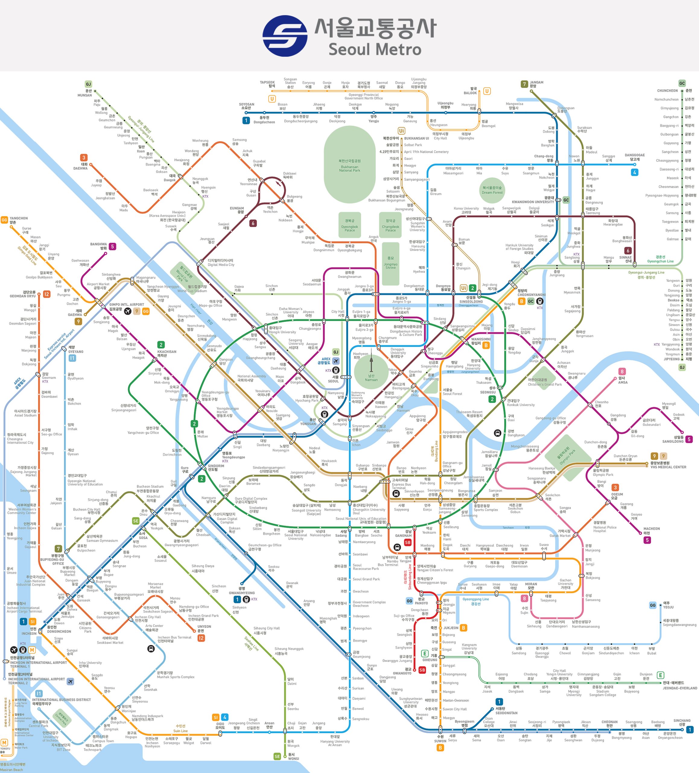
Metro map of Seoul
Map of Seoul Metro showing different lines. Click on the map to enlarge it or download the Seoul Metro map in PDF format.
Lines and Stations
The Seoul Metropolitan Subway’s core consists of nine main lines (Lines 1–9) that serve the city and nearby suburbs. Each line has its own color, route, and purpose, creating a unified and efficient transit network.
Line 1 (Dark Blue)
Line 1 is the oldest route, opened in 1974. It spans about 218.3 km (135.6 mi) with 102 stations. Running north–south and west of downtown, it connects Soyosan and Yeoncheon in the far north through central Seoul (via Seoul Station and City Hall) to several southern branches, including Incheon, Suwon, Sinchang, Gwangmyeong, and Seodongtan. It operates jointly with Korail, sharing tracks with national railways. Major stations include Seoul Station, Yongsan, City Hall, Incheon, and Suwon. This line remains the main artery linking Seoul to outer cities.
Line 2 (Green)
Line 2 is a circular route around central Seoul, covering 60.2 km (37.4 mi) with 51 stations. Opened between 1980 and 1984, it is one of the busiest lines in Korea. The loop connects downtown with Gangnam, Hongdae, and Jamsil, with two short branches to Sinseol-dong and Kkachisan. Notable stations include Gangnam, Hongik University, Jamsil (Lotte World), and Seoul National University of Education. Trains operate in both directions with intervals as short as 2.5 minutes during rush hours.
Line 3 (Orange)
Line 3 opened in 1985 and runs north–south from Daehwa in Goyang to Ogeum in southeastern Seoul. It spans 57.4 km (35.6 mi) with 44 stations. The line serves major locations such as Gyeongbokgung Palace, Jongno 3-ga, and Gangnam’s Express Bus Terminal. The northern section (Ilsan Line) is operated by Korail. Line 3 links Goyang in the northwest with Gangnam in the south. Key stations include Gyeongbokgung, Express Bus Terminal, and Yangjae.
Line 4 (Light Blue)
Opened in 1985, Line 4 runs from Jinjeop in Namyangju (northeast) to Oido in Siheung (southwest). It covers 85.7 km (53.2 mi) with 51 stations. The line crosses downtown at Dongdaemun, Myeongdong, and Seoul Station, making it popular among shoppers and tourists. It continues south across the Han River through Sadang to the coastal areas. Line 4 is jointly operated with Korail. The northern extension to Jinjeop opened in 2022. Key stops include Myeongdong, Seoul Station, and Dongdaemun Market.
Line 5 (Purple)
Line 5, opened in 1995, runs east–west for 63.0 km (39.1 mi) with 56 stations. It starts at Banghwa near Gimpo Airport, passes through central Seoul (Gwanghwamun, Dongdaemun History & Culture Park), and splits into two eastern branches: one to Hanam Geomdansan and another to Macheon. It is the only line that crosses the Han River underwater. Major stations include Yeouido (financial district), Gimpo Airport, Gwanghwamun, and Dongdaemun. The eastern extension to Hanam (2020–2021) expanded service to that city.
Line 6 (Brown)
Line 6 opened in 2000 and connects northern Seoul in an arc from Eungam (northwest) to Sinnae (northeast). It has 39 stations along 36.4 km (22.6 mi). The line passes through Mapo, Itaewon, and Dongdaemun. Although it doesn’t go through central Seoul, it connects residential and entertainment areas. Important stops include Itaewon, World Cup Stadium, and Anam (Korea University). Its eastern end links to the Gyeongchun Line at Sinnae.
Line 7 (Olive Green)
Line 7 opened in 1996 and runs diagonally from Jangam in Uijeongbu (north) to Seongnam in Incheon (southwest). It covers 60.1 km (37.3 mi) with 53 stations. The line passes through northeastern Seoul, Gangnam’s Cheongdam area, and Guro Digital Complex before reaching Bucheon and Incheon. It serves major universities such as the University of Seoul and Konkuk University. Extensions, including a 2021 expansion into Incheon, continue to extend its reach. Major transfer stations include Cheongnyangni and Express Bus Terminal.
Line 8 (Pink)
Line 8 opened in 1996 and connects southeastern Seoul to the northeast. Originally running from Moran (in Seongnam) to Amsa (east Seoul), it was extended to Byeollae in Namyangju in 2024. The line now spans 31 km (19 mi) with 24 stations. It serves Songpa District and Jamsil (Lotte World), crossing the Han River. Key stations include Jamsil, Cheonho, and Moran. The Byeollae extension connects to the Gyeongchun Line, improving access to northeastern suburbs.
Line 9 (Gold)
Line 9, opened in 2009, runs east–west across southern Seoul from Gaehwa near Gimpo Airport to VHS Medical Center in Gangdong District. It covers 40.6 km (25.2 mi) with 38 stations. Line 9 features express trains that stop at 16 major stations, reducing travel time. Key stops include Gimpo Airport, Yeouido, Express Bus Terminal, Gangnam, and Olympic Park. The line was built under a public-private partnership and will eventually extend to Hanam City in the 2030s.
Stations and Facilities
All nine lines are part of a unified network with free transfers when using a transit card. Stations are modern and well-equipped: every station has platform screen doors, elevators or escalators, and free Wi-Fi on platforms and trains. Signs and announcements appear in Korean, English, and often in Chinese and Japanese, making the system easy to use for visitors. Major interchange stations include Dongdaemun History & Culture Park (Lines 2, 4, 5) and Express Bus Terminal (Lines 3, 7, 9). Seoul’s busiest stations—Gangnam (Line 2) and Jamsil (Lines 2, 8)—each serve hundreds of thousands of passengers daily, underscoring the subway’s importance in everyday city life.

Additional Lines
Beyond Lines 1–9, the Seoul Metropolitan Subway includes many additional lines operated by Korail, Incheon Metro, and private companies. These lines are fully integrated into the same fare and transfer system, expanding coverage across the capital region.
AREX (Airport Railroad Express)
AREX connects Incheon International Airport (Terminals 1 and 2) and Gimpo Airport to central Seoul, ending at Seoul Station. Opened in 2007, it has 14 stations. The line offers two services: an express train (non-stop between Seoul Station and Incheon Airport) and an all-stop train serving all intermediate stations. The express takes about 43 minutes from Seoul Station to Incheon Airport. A small extra fare applies for travel beyond Seoul city limits.
Gyeongui–Jungang Line
Operated by Korail, this commuter rail line was created by merging the Gyeongui and Jungang lines. It runs from Dorasan near the DMZ in the northwest through Seoul (Seoul Station and Cheongnyangni) to Jipyeong in eastern Gyeonggi Province. The 138 km (86 mi) route has 57 stations and opened in stages between 2005 and 2014. It connects northern and eastern suburbs and provides easy access to weekend destinations like Imjingang and Yangpyeong.
Gyeongchun Line
Opened in 2010, the Gyeongchun Line runs 81 km (50 mi) from northeast Seoul (Sangbong / Cheongnyangni) to Chuncheon in Gangwon Province. It has 24 stations and connects directly to the Seoul Metro at Sangbong and Cheongnyangni. The line serves both commuters from the northeast suburbs and tourists visiting Gapyeong and Chuncheon, known for their scenic lakes and resorts.
Suin–Bundang Line
Formed by merging the Bundang Line (1994) and Suin Line (2012), this Korail line was completed in 2020. It now runs 104.6 km (65 mi) with 63 stations from Wangsimni in eastern Seoul to Incheon Station on the west coast. The route passes through Suwon, Yongin, and Ansan, linking multiple satellite cities. Passengers can, for example, travel from Suwon to Gangnam by transferring at Wangsimni to Line 2. It’s fully integrated into the metro fare system.
Shinbundang Line
Opened in 2011, this privately operated express subway connects Sinsa in southern Seoul with Gwanggyo (Suwon) through the Bundang area. The line has 16 stations over 33.4 km (20.8 mi) and operates driverless trains at speeds up to 90 km/h (56 mph). It cuts travel time between Gangnam and Pangyo to about 15 minutes. A distance-based surcharge of ₩500–₩1,900 (about $0.35–$1.35) applies due to its premium service.
Incheon Metro (Lines 1 and 2)
Incheon operates two metro lines as part of the wider Seoul network. Incheon Line 1 opened in 1999 and spans 30.3 km (18.8 mi) with 30 stations, running from Geomdan in the north to Songdo International City in the south. Incheon Line 2 opened in 2016, stretching 29 km (18 mi) with 27 stations across the city. Line 1 connects with Seoul’s Line 1 and Line 7, while Line 2 connects with Line 7 at Seongnam (Bucheon). Both lines allow seamless travel using a single transit card.
Light Metro Lines
Seoul and nearby cities also operate smaller automated lines known as light metros or people movers:
- Ui LRT (Ui–Sinseol Line): Opened in 2017, it runs 11.4 km (7.1 mi) with 15 stations in northern Seoul, linking Ui-dong with Sinseol-dong (Line 1/4). It serves local neighborhoods along the city’s edge.
- Sillim Line: Launched in 2022, this 7.8 km (4.8 mi) route in southwestern Seoul has 11 stations. It connects Saetgang near Yeouido through Sillim to Gwanaksan near Seoul National University.
- Yongin EverLine: Opened in 2013, this 15-station automated line links Giheung (transfer to Bundang Line) with Everland theme park, providing a direct route for park visitors.
- Uijeongbu U Line: A monorail that opened in 2012, running 11.3 km (7 mi) with 16 stations in Uijeongbu. It connects with Seoul Line 1 and charges a small extra fare of ₩300 (about $0.20).
- Gimpo Goldline: Opened in 2019, this 23.7 km (14.7 mi) driverless metro in Gimpo connects Gimpo Airport with Yangchon across 10 stations. It links directly to Lines 5, 9, and AREX at Gimpo Airport.
Other Commuter Lines
Korail also operates additional suburban routes, including:
- Gyeonggang Line (opened 2016): 11 stations linking Pangyo to Yeoju.
- Seohae Line (opened 2018): 21 stations connecting Ilsan in the northwest to Ansan in the southwest, linking with Line 1 at Daegok and Line 4 at Choji.
Integration and Network Scale
All these lines use the same T-money fare card and allow free or discounted transfers, making the entire system feel unified. For example, passengers can travel from Songdo on Incheon Line 1, transfer to Line 1 or 4, and continue on Seoul Metro lines without buying another ticket. Together with future high-speed GTX routes, these lines make the Seoul Metropolitan Subway one of the largest and most interconnected urban rail networks in the world.
Schedule, Timetables, and Calendar
The Seoul subway operates year-round, 365 days a year, with consistent service across all lines. Trains generally run from about 5:30 am until around midnight. The first departures leave terminal stations around 5:30 am, and the last trains depart near midnight. On Fridays and Saturdays, some major lines operate slightly later, with final departures between 12:30 am and 1:00 am. There is no 24-hour service—overnight hours are reserved for daily maintenance.
Train frequency is high, especially during rush hours (7–9 am and 6–8 pm). During these times, trains on major lines run every 2–3 minutes. Line 2, the circular line, is among the busiest, with intervals as short as 2 minutes 18 seconds during peak periods. During off-peak hours, trains usually arrive every 5–6 minutes on busy routes and every 8–10 minutes on quieter lines or late at night. After 11 pm, intervals widen to about 10–15 minutes. On weekends, service is similar but may start slightly later on Sundays, around 6 am. Overall, trains arrive frequently—every 2 to 10 minutes depending on the time of day—so long waits are rare.
Each line and direction has its own timetable showing the first and last train times for every station. This information is displayed in stations and available on official apps. As a general rule, the last trains from central Seoul depart around midnight from major hubs. Travelers should plan accordingly, as the system stops after 1 am. During the overnight gap, night buses and taxis are available until service resumes around 5 am.
Some lines have unique timetable patterns. On Line 1, certain trains turn back before reaching the final station, while Line 9 operates both local and express services with separate schedules—express trains usually run every 5–10 minutes during rush hours. These details are clearly shown on station timetables and electronic displays. Real-time train information is also available on platforms and mobile apps, showing exact arrival times and train types.

Tickets, Prices, and Cards
Seoul’s subway uses a unified distance-based fare system covering the city and suburbs. The fare depends on travel distance but remains consistent across all lines and is integrated with city buses. Below is a summary of fares and ticket types as of 2026.
Fares by Passenger Type
| Ticket Type / Rider | Base Fare | USD Approx. | Details |
|---|---|---|---|
| Adult (Transit Card) | ₩1,400 for up to 10 km | ~$1.00 | Base fare using T-money or Cash Bee card. +₩100 per 5 km after 10 km, +₩100 per 8 km after 50 km. Includes free transfers to other lines and buses. |
| Adult (Single-Use Ticket) | ₩1,500 for up to 10 km | ~$1.10 | ₩100 surcharge compared to card. Includes a refundable ₩500 deposit. Same distance surcharges apply. |
| Youth (ages 13–18) | ₩1,000 for up to 10 km | ~$0.70 | 20–30% discount from adult fare with registered youth card. Distance surcharges apply at reduced rates. |
| Child (ages 6–12) | ₩700 for up to 10 km | ~$0.50 | 50% discount from adult fare using a registered child card. Children under 6 ride free with an adult. |
| Senior (65+) & Disabled | Free | $0.00 | Free subway travel for seniors 65+ and registered disabled persons with valid ID or special transit card. |
The base fare covers 10 km (6.2 mi). After that, ₩100 (~$0.07) is added for every 5 km (3.1 mi) up to 50 km (31 mi), and ₩100 for every 8 km (5 mi) beyond that. For example, a 20 km (12 mi) ride costs ₩1,500 (~$1.10), and a 60 km (37 mi) trip about ₩1,700 (~$1.25). Transfers between subway lines or to buses are free within 30 minutes (or 60 minutes late at night) when using a transit card. Some lines, such as Shinbundang or AREX Express, have small surcharges.
Single-Use Tickets
Single-use paper tickets cost ₩1,500 (~$1.10) for short trips and include a ₩500 (~$0.35) refundable deposit, returned after the trip at a machine. They are convenient for tourists or occasional riders but slightly more expensive than using a card.
T-money Cards
The T-money card is the most popular way to pay. It’s a rechargeable smart card used on all subways, buses, and taxis in Seoul and most of Korea. A new T-money card costs ₩5,000 (~$3.70) and can be bought at subway stations, convenience stores, or tourist centers. You can load amounts starting from ₩1,000 (~$0.70) at machines or stores. Simply tap in at entry and tap out at exit; the system automatically deducts the correct fare.
Using T-money gives a ₩100 (~$0.07) discount compared to cash and allows free transfers. It also works for small payments at convenience stores and vending machines. If you transfer between subway and bus, always tap when exiting and boarding to calculate the correct fare.
The card can be refunded for leftover balance (up to ₩20,000 / ~$15) at convenience stores, minus a ₩500 (~$0.35) fee. Other compatible cards, such as Cash Bee, work the same way, but T-money is the most common. Tourist versions like MPass are also available.
Children and Youth Fares
Children and teenagers receive discounts only when using registered cards. Kids under 6 ride free when accompanied by an adult (up to 3–4 children per adult). For children aged 6–12, the fare is half the adult rate — ₩700 (~$0.50). To activate the discount, purchase a Child T-money card and register the child’s birth date at a station or convenience store.
Youth (ages 13–18) receive about 20–35% off adult fares, paying roughly ₩1,000 (~$0.70). They must use a registered Youth T-money card. The discount applies until age 19 or high school graduation. Unregistered cards will charge the full adult fare. For foreign children or teens, proof of age (passport) may be required at purchase.
Senior Citizens and Disabled Riders
Seniors aged 65 and over and registered disabled passengers travel free on all subway lines. Most use a senior or disability T-money card that deducts no fare. Visitors aged 65+ can also show their passport at a station office to receive a free single-use ticket. Gates have dedicated entry points for free-pass users.
Accessibility
All stations have elevators or lifts, and new ones are fully barrier-free with tactile paving, accessible restrooms, and visual/audio announcements. Priority seats are clearly marked for elderly, pregnant, and disabled passengers. Accessibility and free fares make the Seoul subway one of the most inclusive transit systems in the world.

Connections
Seoul’s subway system is one of the most interconnected in the world. Passengers can transfer between subway lines or switch to buses, trains, and airport links—all under one fare system. Transfers are easy to follow thanks to clear signage and English labels. At interchange stations, you move between lines through transfer corridors without exiting the fare gates. Large hubs like Dongdaemun or Sindorim connect two or three lines, sometimes requiring long walks, but the routes are well-marked.
Transfers between lines are free and unlimited within a single journey. For example, you can ride Line 3, transfer to Line 1 at Jongno 3-ga, then switch to Line 5—all within the station and without paying extra.
Subway and Bus Connections
Every subway station in Seoul has nearby bus stops, ensuring full city coverage. Many city bus routes are designed to connect directly with subway stations.
When transferring between subway and bus, simply tap out of the subway and onto the bus within 30 minutes (or 60 minutes at night). You won’t pay a new base fare—only any additional distance fare if applicable. The fare integration makes multi-leg travel seamless and affordable.
Connections to National Rail
- Seoul Station (Lines 1 & 4): Serves as a major hub for KTX high-speed trains, ITX, and Mugunghwa services. It’s also the terminus of the AREX airport line, offering direct links to both airports.
- Yongsan Station (Line 1): Another KTX hub, especially for trains on the Honam Line to southern regions.
- Cheongnyangni Station (Line 1 & Gyeongchun Line): Connects to ITX trains to Chuncheon and some KTX routes.
- Suseo Station: Terminal for SRT high-speed trains, connected indirectly via the Shinbundang Line at Dongcheon.
- Gwangmyeong Station (Line 1 branch): Serves KTX trains southwest of Seoul, accessible via a Line 1 shuttle.
Connections to Bus Terminals
Several subway stations are directly linked to intercity and airport bus terminals:
- Express Bus Terminal Station (Lines 3, 7, 9): Located beneath the Seoul Express Bus Terminal, offering easy access to long-distance buses nationwide.
- Bongeunsa Station (Line 9): Connects to Seoul City Air Terminal, with limousine buses to both airports.
- Gangbyeon Station (Line 2): Adjacent to Dong Seoul Bus Terminal for provincial routes.
This tight integration between rail and bus networks allows travelers to move between local, regional, and national transport options quickly and conveniently.
Connectivity Overview
- Subway-to-subway: Hundreds of free transfer combinations across the network.
- Subway-to-bus: All stations connect to bus routes under the same fare card system.
- Subway-to-airport: Direct connections via AREX or Line 9.
- Subway-to-train: Linked to major rail stations such as Seoul and Yongsan.
- Subway-to-taxi: Taxi stands are located outside most station exits, useful after subway hours.
Seoul’s buses are color-coded: blue for long routes, green for local routes, red for suburban express, and yellow for circulator routes. Bus maps are displayed near most subway exits for quick reference.
Connection to the Airport
Seoul has two main airports: Incheon International Airport (ICN), about 50 km (31 mi) west of the city, and Gimpo International Airport (GMP), within Seoul’s western area. Both are directly connected to the subway system.
Incheon International Airport (ICN)
The fastest route is the AREX (Airport Railroad Express):
- AREX Express Train: Non-stop from Seoul Station to Incheon Airport Terminal 1 and Terminal 2 in about 43 minutes. Reserved seating and luggage racks. Fare: ₩9,000–₩10,000 (~$6.60–$7.40).
- AREX All-Stop Train: Stops at 12 intermediate stations. Travel time: about 56 minutes to Terminal 1 from Seoul Station, and a few minutes longer to Terminal 2. Fare: ₩4,750 (~$3.50). Trains run every 5–10 minutes for all-stop and every 20–40 minutes for express.
Passengers can also reach Incheon Airport by transferring at Gimpo Airport Station from Line 5 or Line 9 to the AREX all-stop service. From eastern Seoul, for example, take Line 2 to Yeouido, Line 9 to Gimpo, then AREX to ICN. Although other routes exist, AREX remains the fastest and simplest.
Gimpo International Airport (GMP)
Gimpo Airport is directly served by multiple subway lines:
- Line 5: From central Seoul (e.g., Gwanghwamun or Yeouido) to Gimpo Airport takes about 40–50 minutes.
- Line 9: Connects Gangnam and Yeouido areas; express trains reach Gimpo in about 30 minutes from Sinnonhyeon.
- AREX All-Stop: Also stops at Gimpo Airport en route to Incheon, providing another easy transfer option.
Using the subway to reach either airport is affordable and efficient. A trip to Incheon Airport on AREX costs around ₩4,000–₩5,000 (~$3.00–$3.70), compared to ₩17,000 (~$12.50) for an airport limousine bus. AREX trains offer luggage racks and step-free access, making them ideal for travelers with baggage.
At Incheon Airport, AREX stations are located beneath Terminals 1 and 2. Express and all-stop trains use separate platforms, with clear signage guiding passengers to the terminals. A small maglev train also operates locally on Yeongjong Island but is not used for travel to Seoul.
Overall, Seoul’s transit connections—between subways, buses, airports, and railways—create one of the most comprehensive and user-friendly transport systems in the world.

Tips and Rules
- Plan for rush hour: Avoid 7–9 AM and 6–8 PM if possible. Trains can be packed, especially on Lines 2 and 9. Midday and late evening are calmer.
- Let riders exit first: Form lines on the platform edges, wait for passengers to get off, then board in order.
- Queue and board politely: Follow floor arrows. Do not push. At major hubs, locals queue strictly—do the same.
- Priority seats: Reserved seats (blue for elderly/disabled, pink for pregnant riders) are for those who need them. Give up your seat immediately if required.
- No eating or drinking: Don’t eat meals on trains. Water is fine if discreet. No open alcohol. Keep trains clean.
- Keep noise down: Use headphones. Keep calls short and quiet. Some cars are quiet zones—no calls there.
- Bags and luggage: Remove backpacks on crowded trains and hold them by your side. Large suitcases are allowed but avoid peak hours. Use luggage racks when available.
- Escalators: Stand on the right; the left is for walking. Safety campaigns advise not walking, but the right-side rule is common. Hold the handrail.
- Follow exit numbers: Stations can have many exits. Check maps for the nearest exit to your destination to save time.
- Station facilities: Free restrooms are common. Many stations have convenience stores, lockers, ATMs, and charging points. Staffed information desks can help.
- Safety: The system is very safe. Watch your belongings in crowds. Cars have CCTV and emergency intercoms. Late at night, choose busier cars (usually the middle).
- Photography: Casual photos are fine. Don’t photograph strangers without consent. Large-scale filming may require permission.
- Official rules: No smoking or hazardous items. No running on escalators. Folding bikes are allowed anytime; full-size bikes only off-peak, usually in the last car on weekends. Fold e-scooters. Pets must be in carriers. No selling or busking without permission.
Fun facts
Ridership and rank. About 2.5 billion annual riders (≈ 6.8 million daily). Line 2 alone carried 812 million riders in 2019.
Network length. The full network exceeds 1,300 km (≈ 810 mi). The core Lines 1–9 total over 331 km (≈ 206 mi).
Loop line milestone. Line 2’s main loop is 48.8 km (≈ 30.3 mi)—formerly the world’s longest circular metro line and still among the top three by length.
Technological firsts. Seoul introduced contactless smart cards in 1996 and completed full platform screen door installation by 2017. Seolleung Station hosted the first “virtual supermarket” in 2011.
Connectivity on board. Free Wi-Fi is widespread. Trains feature information displays. Cars are climate-controlled; seats are heated in winter.
Cleanliness and reliability. Trains are cleaned frequently and run on time. Delays over five minutes are unusual.
Depth and engineering. Some stations are very deep underground, with long escalators and multi-level interchanges (e.g., Express Bus Terminal with Lines 3/7/9).
Art and culture. Many stations display local history or themed art—Gwanghwamun, Anguk, Dongdaemun History & Culture Park, Sports Complex, and Myeongdong are notable examples.
Longest possible ride. With integrated fares and slow distance increments after long ranges, you can traverse 150+ km (≈ 93+ mi) in one journey within the time limit (typically four hours).
Safety campaigns. Friendly mascots promote etiquette and safety. Some stations play brief classical or traditional music before the last train.
Economic impact. Proximity to stations raises property values and supports dense, transit-oriented growth. Public transit share exceeds 60% of trips.
“Hell Train” nickname. Peak-hour crush loads inspired nicknames for certain corridors (e.g., Line 9). Seatless cars on Lines 4 and 7 were tested to add standing space.
History
Seoul’s subway system began in the 1970s and expanded in stages over the decades. Construction of Line 1 started in 1971, and it opened on August 15, 1974. The first route connected central Seoul with Korail’s suburban lines.
Line 2, the circular line, opened in 1980, followed by Line 3 and Line 4 in 1985, forming a cross-shaped network through the city. Rapid growth continued in the 1990s: Line 5 opened in 1995, Lines 7 and 8 in 1996, and Line 6 in 2000. These new routes extended metro service to outer districts and suburbs.
By 2000, Seoul operated an extensive eight-line system. In 2004, a distance-based fare system with free transfers to buses was reintroduced, making travel across the city more convenient.
In the following years, the network integrated regional rail lines and new metro routes. Incheon Subway Line 1 opened in 1999, connecting the neighboring city of Incheon. Korail commuter lines joined the system: the Jungang Line in 2005 and the Gyeongui Line in 2009.
The privately operated Line 9 launched in July 2009, introducing express metro services. During the 2010s, new routes and extensions followed: the high-speed Shinbundang Line in 2011, the Yongin EverLine and Uijeongbu U Line in 2012, and the Gyeongchun Line to Chuncheon in 2010.
A major milestone came in 2020 when the Suin and Bundang lines were connected, forming the Suin–Bundang Line that runs from southeastern Seoul to Incheon. Line 4 extended north to Jinjeop in 2022, and Line 8 expanded north to Byeollae in 2024, adding six new stations and reaching 30.6 km (about 19 mi) in total length.
Over five decades, the Seoul Metropolitan Subway has grown from one line into a massive network that carries billions of passengers each year.
Technological innovation has always been central to its progress. In 1996, Seoul introduced one of the world’s first contactless smart cards, the Upass, which later evolved into today’s T-money system. By 2017, all stations had platform screen doors for improved safety. In 2011, the world’s first “virtual supermarket” opened at Seolleung Station, allowing passengers to shop using their smartphones while waiting for trains.
Through ongoing modernization and expansion, Seoul’s subway has become a fast, efficient, and globally admired urban transit system by 2026.

Future Expansions
The Seoul Metropolitan Subway is still growing. As of 2026, multiple projects are underway to add lines, extend routes, and boost capacity.
New Lines Opening Soon
Several light metro lines are in construction. Dongbuk Line in the northeast (Wangsimni–Sanggye, 14 stations) targets 2026. Wirye Line, a tram/light rail in the southeast, is also slated for 2026, linking Macheon (Line 5) with Bokjeong (Line 8/Bundang) and Namwirye. The Myeonmok Line (Cheongnyangni–Sinnae, 12 stations) is approved and planned around 2030.
Subway Line Extensions
- Line 7: Extending northwest to Goeup (Yangju) around 2026–26 (2 stations), then further to Pocheon by ~2030 (4 stations). On the west, extending from Seongnam (Incheon) to Cheongna International City by 2027 (6 stations), with a long-term goal toward Incheon Airport.
- Line 8: Proposed short southward extension from Moran to Namdong (Seongnam) and potential links toward Suwon (under study). The Byeollae end may connect to future Namyangju projects.
- Line 9: Eastward extension from VHS Medical Center to Saemteo Park (Hanam) by ~2028 (4 stations, connection to Line 5 at Godeok). A further extension to Hanam City Hall (6 stations) is approved for the early 2030s.
- Line 3: Planned westward extension to Ilsan (Daehwa–Samsong) and an eastern plan beyond Ogeum toward Bundang (Yongin). An envisioned Eastern Extension (Ogeum–Pungyang in Guri, 8 stations) targets the 2030s.
- Line 5: A western extension from Banghwa toward Goyang and possibly Gimpo is under study.
- Line 10: Long-term concept; other prioritized lines proceed first.
New Mega Projects (GTX)
GTX is a new high-speed commuter rail class that integrates with subway hubs and slashes regional travel times.
- GTX-A: Partial service began in 2023/24. Full opening by around 2026 from Unjeong (north) to Dongtan (south), with central stops at Seoul Station and Samseong. Example: Ilsan–Gangnam in ~20 minutes.
- GTX-B / GTX-C: In planning; targeted around 2030. GTX-B will link southwest Incheon to northeast Gyeonggi; GTX-C will run from Yangju (northeast) to Suwon (southwest).
- Future lines (e.g., D/E) are under discussion.
Capacity Upgrades
- New trains and refurbishments across several lines.
- Higher frequency enabled by upgraded signaling.
- Line 9 platform extensions and trials of 8-car trains (originally 6-car) to boost capacity.
- Lines 5–8 receiving new rolling stock as mid-1990s fleets age.
- Ongoing station works: improved screen doors, ventilation, and wayfinding.
Tourist attractions

- Palaces: Gyeongbokgung (Line 3: Gyeongbokgung; Line 5: Gwanghwamun), Changdeokgung (Line 3: Anguk), Deoksugung & City Hall (Lines 1/2: City Hall).
- Myeongdong: Line 4: Myeongdong; also near Line 2: Euljiro 1-ga.
- Namdaemun Market: Line 4: Hoehyeon; walk from Seoul Station.
- Dongdaemun & DDP: Line 2/4/5: Dongdaemun History & Culture Park.
- N Seoul Tower: Line 4: Myeongdong, Exit 3 for the cable car shuttle or walk.
- Hongdae: Line 2 & AREX: Hongik Univ. Station.
- Itaewon: Line 6: Itaewon.
- Gangnam & COEX: Line 2: Gangnam; Line 2: Samseong for COEX & Bongeunsa.
- Lotte World: Line 2/8: Jamsil (connected to the mall; short walk to the park).
- Bukchon Hanok Village: Line 3: Anguk or Lines 1/3/5: Jongno 3-ga, then a 10–15 minute walk.
- National Museum of Korea: Line 4: Ichon.
- War Memorial: Lines 4/6: Samgakji.
- Han River Parks: Line 5: Yeouinaru and other riverside stops; Line 7 also serves several parks.