Kyiv Metro Information
The Kyiv Metro, the first rapid transit system built in Ukraine, is one of the most important public transport systems in Kyiv, Ukraine. It was inaugurated on 6 November 1960 and has grown considerably since then. The network consists of 3 lines serving 57 stations over a length of 67.6 km. Of these 57 stations, Arsenalna is one of the deepest stations built not only in Ukraine but in the world. Although the metro is owned by Kyiv City Council, it is actually operated by Kyivskyi Metropoliten. The popularity and importance of this system is demonstrated by its daily and annual ridership of 1.439 million (2012) and 536.2 million (2013) respectively.
The Kyiv Metro in Ukraine serves approximately 1,760,000 passengers daily. It does not operate 24 hours a day, but only from 4.45am to midnight.
The Kyiv Metro has no air conditioning and passengers cannot walk between platforms. There are no driverless trains and there are no screen doors on the platforms.
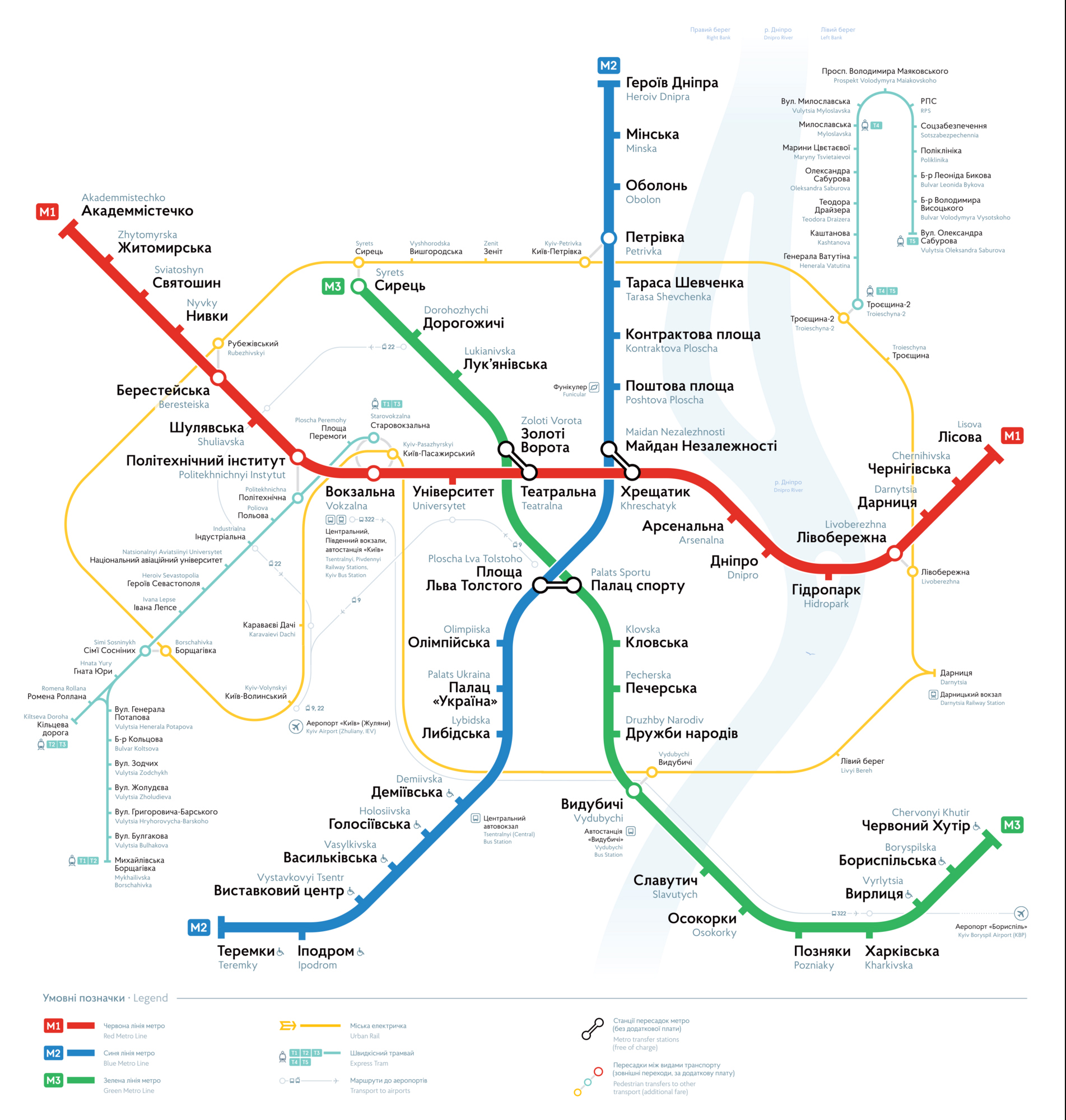
Kyiv Metro Map
Map of Kyiv Metro showing different lines. Click on the map to enlarge it or download the Kyiv Metro map in PDF format.
Lines and Stations
The Kyiv Metro is an underground train system that operates under the capital city of Ukraine. It consists of three interconnected lines serving numerous areas within the city. The system has 52 stations, the majority of which are underground (20 deep stations, 6 normal underground stations, 20 underground stations, 4 surface stations and 2 elevated stations).
Line 1: Sviatoshynsko-Brovarska
Line 1, also known as Sviatoshynsko-Brovarska, represented by the colour red, was the first line in the system. Initially it had only 5 stations, covering a distance of 5 km. Today it stretches over 22 km and has 18 stations, tying with Line 2 for the most stations on a line. The last extension of this line was completed in 2003. It runs from east to west, ending at Akademmistechko in the west and Lisova in the east. A full journey on this line takes about 38.5 minutes.
Line 2: Kurenivsko-Chervonoarmiyska
The second line to be built, Kurenivsko-Chervonoarmiyska, runs north-south along the western bank of the Dnieper River. It was quite short when it opened in 1976, but several extensions over the years, the latest completed in 2013, have resulted in a line that now has 18 stations along a 20.95km route. The line terminates at Heroiv Dnipra in the north and Teremky in the south. This line is marked in blue.
Line 3: Syretsko-Pecherska
The most recent addition to the Kyiv Metro is Line 3, or Syretsko-Pecherska, identified by the color green. Inaugurated in December 1989, the line has since been extended and is now the longest in the system at 23.9 km. It currently serves 16 stations and a journey from end to end takes about 40 minutes. The line runs from north-west to south-east, with planned extensions to the north-east of the city. The last extension of the line was completed in 2008. Its terminus is at Syrets and Chervony Khutir.
Connections with Other Systems
While the Kyiv Metro is widely used, the vastness of the city necessitates additional public transportation. As the metro continues to expand, it is consolidating its position as the city’s primary public transport system, although many commuters still rely on other modes of transport. The metro is operated by Kyivskyi Metropoliten, while another state-owned company, Kyivpastrans, operates all surface transport.
The tram network is probably the second most important system in the city. Trams have a long history in Kyiv, with the first one inaugurated back in the Russian Empire in 1892. Although the network is not as extensive as it once was, there are still several lines that run through the city centre. There are 23 lines in the network, with a total system length of 230.2 km. Kyiv also has an extensive trolleybus network, being emission-free this system is seeing ongoing expansion. The trolleybus network, which dates back to 1935, now covers 499.7 km.
Numerous bus lines also operate in Kyiv, with 80 lines servicing the entire city using various types of buses. Most metro stations have bus connections, creating an integrated public transport system. Due to the city’s unique and challenging landscape, Kyiv also has an unusual form of public transport: a funicular railway. It opened to the public in 1905, connecting the modern city with the historical center of Kyiv situated atop a hill.
The latest addition to the city’s public transport is the electric train. With just one line and a system length of 50.8 km, the train operates on a circular path on the outskirts of Kyiv, connecting its suburbs. It is operated by the state company Ukrzaliznytsya. For long-distance travel, Kyiv has several railway stations, the most important of which is Kyiv-Pasazhyrskyi. It is the country’s main railway station and is directly served by the number 1 metro line at Vokzalna station. Other secondary stations are located in the suburbs. Another tourist favourite is the River Tram, which runs along the Dnieper River and serves 5 stations on 2 different routes.
Connections to the Airports
Kyiv is served by two nearby airports. The larger and more significant of these is Boryspil International Airport, located approximately 29 km southeast of Kyiv and close to the neighboring city of Boryspil. It is Ukraine’s main airport and handles most of the country’s air traffic and routes. There is no direct connection to the metro system. To reach Kyiv from this airport, passengers must use other forms of transport, such as SkyBus line 322, a shuttle service that connects the airport with the railway station south of Kyiv and Kharkivska station of Metro line 3. Boryspilska station on Line 3 is approximately 18 km from the airport.
The other airport, Kyiv International Airport (Zhuliany), is smaller and mainly used for domestic and government flights. Located about 7km south-west of the city in the Zhuliany district, it is better connected to the city than Boryspil Airport, although there is no direct metro link. Trolleybus line 22 connects it to Metro line 3 at Dorohozhychi station. Bus number 78 also serves this airport, connecting it with Vasylkivska station of Metro Line 2. There are plans to connect the airport directly to the metro system through a future extension of Line 4.
Schedule and Timetables
The schedule of the Kyiv Metro varies according to the station and line in question. In general, however, most stations open at around 5.30am and close just after midnight.
Lines and Stations
The Kyiv Metro is an underground railway system that serves the capital city of Ukraine. It consists of three lines that cross many parts of the city. The system has 52 stations, most of which are also underground (including 20 deep stations, 6 standard underground stations, 20 shallow underground stations, 4 surface stations and 2 elevated stations).
Line 1: Sviatoshynsko-Brovarska
Line 1, also known as Sviatoshynsko-Brovarska, marked in red, was the first line in the system. Originally it had only 5 stations spread over 5 km. Today it is over 22 km long and consists of 18 stations (it shares the most stations on a line with line 2). The last extension of this line was completed in 2003. It runs from east to west; its terminals are Akademmistechko in the west and Lisova in the east. A full journey on this line takes about 38 and a half minutes.
Line 2: Kurenivsko-Chervonoarmiyska
Chronologically, this was the second line to be built. Known as Kurenivsko-Chervonoarmiyska, it runs north-south along the western bank of the Dnieper. It was a short line when it opened in 1976. Since then it has undergone several extensions, the latest of which was completed in 2013. At present, the line has a total of 18 stations spread over a length of 20.95 km. Its terminal stations are Heroiv Dnipra in the north and Teremky in the south. This line is marked by the colour blue.
Line 3: Syretsko-Pecherska
The most recent addition to the Kyiv Metro, Line 3, was inaugurated in December 1989. It is also known as Syretsko-Pecherska and is identified by the colour green. Although it is the newest line in the system, some recent extensions have made it the longest at 23.9 km. It currently has 16 stations and a journey from one end to the other takes about 40 minutes. This line runs from north-west to south-east, but planned extensions will extend it to the north-east of the city. The last extension of this line was completed in 2008. Its terminus is at Syrets and Chervony Khutir.
Connections with Other Systems
Even though the Kyiv Metro is used by a large number of people, a city of this size cannot be entirely covered by a single public transport system. With each new extension to the system, the metro is consolidating its position as the main form of public transport, but many people still rely on other forms of transport for their daily commute. The metro is operated by Kyivskyi Metropoliten, but another government-owned company, Kyivpastrans, operates all surface transport systems.
The second most important system in the city is probably the tram network. Trams have a long history in Kyiv, with the first tram in the city inaugurated during the time of the Russian Empire in 1892. The network is not as extensive as it once was, but there are still several lines running through the city centre. There are 23 lines in the network, with a total system length of 230.2 km. The city also has a trolleybus network. This emission-free public transport system is being expanded. With a history dating back to 1935, it now has an extensive network with a system length of 499.7 km.
Of course, many bus lines also operate in Kyiv. 80 lines serve the entire city with a variety of bus types. Most metro stations are connected to the bus network, forming an integrated public transport system. Kyiv, with its peculiar and challenging landscape, also operates a rather unusual form of public transport: a funicular railway. It was opened to the public in 1905 and connects the modern city with the historical center of Kyiv that is located on top of a hill.
The latest addition to the city’s public transport is the electric train. With just one line and a system length of 50.8 km, the train operates on a circular route on the outskirts of Kyiv, connecting its suburbs. It is operated by the state company Ukrzaliznytsya. For long-distance travel, Kyiv has several railway stations, the most significant of which is Kyiv-Pasazhyrskyi. It is the most important railway station in the country and is directly served by metro line 1 at Vokzalna station. Other secondary stations are located in the suburbs. Last but not least: a tourist favourite. Kyiv also has a river tram, which flows along the Dnieper River. It serves 5 stations on 2 different routes.
Connections to the Airports
Kyiv has two nearby airports. The larger and more important of these is Boryspil International Airport, located about 29 km southeast of Kyiv and close to the neighboring city of Boryspil. It is the most important airport in Ukraine, handling most of the country’s air traffic and routes. There is no direct connection to the metro system. To reach Kyiv from this airport, passengers must use other forms of transport, such as SkyBus line 322, a shuttle service that connects the airport with the railway station in the south of Kyiv and Kharkivska station of line 3 of the metro. Boryspilska station of metro line 3 is about 18 km from the airport.
The other airport, Kyiv International Airport (Zhuliany), is smaller and mainly used for domestic and government flights. Located about 7km south-west of the city in the Zhuliany district, it is better connected to the city than Boryspil Airport, although there is no direct metro link. Trolleybus line 22 connects it to metro line 3 at Dorohozhychi station. Bus number 78 also serves this airport, connecting it with the Vasylkivska station of metro line 2. There are plans to connect the airport directly to the metro system through a future extension of Line 4.
Schedule and Timetables
The schedule of Kyiv Metro varies depending on the station and line. In general, however, most stations open around 5.30 am and close just after midnight.
Advice
Traveling on the Kyiv Metro, like any other public transport system worldwide, requires some considerations to ensure a smooth journey:
- All passengers must enter the system through turnstiles, which require a valid token or card. It is therefore essential to have a valid ticket before entering the system.
- Passengers are advised to familiarise themselves with ticket prices and options before entering the system as queues can form quickly.
- Planning your trip in advance can help optimise travel times and avoid confusion or delays.
- As the system primarily uses the Ukrainian language and has limited foreign language signage (with Latin transliteration only recently introduced), don’t hesitate to ask staff for assistance if needed.
Fun Facts
- The Kyiv Metro was the third metro system built in the Soviet Union, following Moscow and Leningrad (St Petersburg).
- It has the deepest station in the world: Arsenalna station, which is 105.5 metres below the surface.
- It’s interesting to note that immediately after the deep Arsenalna station there is an elevated station (Dnipro Station). This significant difference in altitude is a world record in itself.
- Following the dissolution of the Soviet Union and Ukraine’s declaration of independence, the metro underwent significant changes, including the transition from bilingual Russian-Ukrainian signage and announcements to Ukrainian only.
Tourism and Sightseeing
A dynamic and diverse city, Kyiv offers a wide range of attractions and entertainment options, many of which are easily accessible via the metro:
Maidan Nezalezhnosti: Known as Independence Square, this central city square is famous for its commercial areas and as a popular location for demonstrations and protests. It features a statue that has become a symbol of the city and a popular tourist attraction. It is directly served by line 2 at Maidan Nezalezhnosti station.
Ukrainian National Opera: As the country’s premier cultural institution, the Ukrainian National Opera leaves visitors in awe of its stunning exterior architecture and intricate interior design. It boasts one of the world’s finest auditoriums and has hosted some of the world’s most renowned opera singers. It is located near the Zoloti Vorota stop on Line 3.
St Sophia’s Cathedral: Recognised as a UNESCO World Heritage Site in 1990, construction on the cathedral began in 1037. Although it has suffered considerable damage over the centuries, the remaining structure is still a magnificent sight and a major tourist attraction. It is conveniently located near Zoloti Vorota station on line 3.