Sydney, Australia’s most populous and famous city, is a bustling metropolis. It is home to over 5 million people, about 20% of the country’s population.
Renowned for its high standard of living, Sydney is a vibrant city that warmly welcomes foreigners. Its attractions range from exceptional educational opportunities to vibrant business, tourism, cultural and sporting scenes.
Despite sharing similarities with major US cities and cultural elements with the United States, Australia prides itself on unique aspects that set it apart, including its public transport system.
Sydney’s transport infrastructure consists of a bus line, a suburban railway and two metro lines, which will be operational in 2019.
Of particular importance is the city’s suburban railway, which operates under the Sydney Trains brand. It offers extensive connectivity, almost equivalent to a metro system.
Established in 2013 after a series of controversies with previous operators, Sydney Trains has a total of 178 stations and 815 kilometres (506 miles) of track spread across 8 lines. It effectively connects the entire metropolitan area and surrounding suburbs.
The Sydney Metro project is currently under construction. With a planned route of 66 kilometres (41 miles), it is expected to be operational by early 2019.
Despite the upcoming Sydney Metro, the existing Sydney Trains system continues to be upgraded to meet the city’s evolving transport needs.
The Sydney Metro, also known as Cityrail, is a public transport system in Sydney, Australia. The fare for a trip on the Sydney Metro is 2.92 Australian dollars.
The Sydney Metro operates daily from 3:51am to 2:25am. It does not offer 24-hour service, the ability to walk between platforms, driverless trains or screen doors on platforms. However, it does provide air conditioning for its passengers.
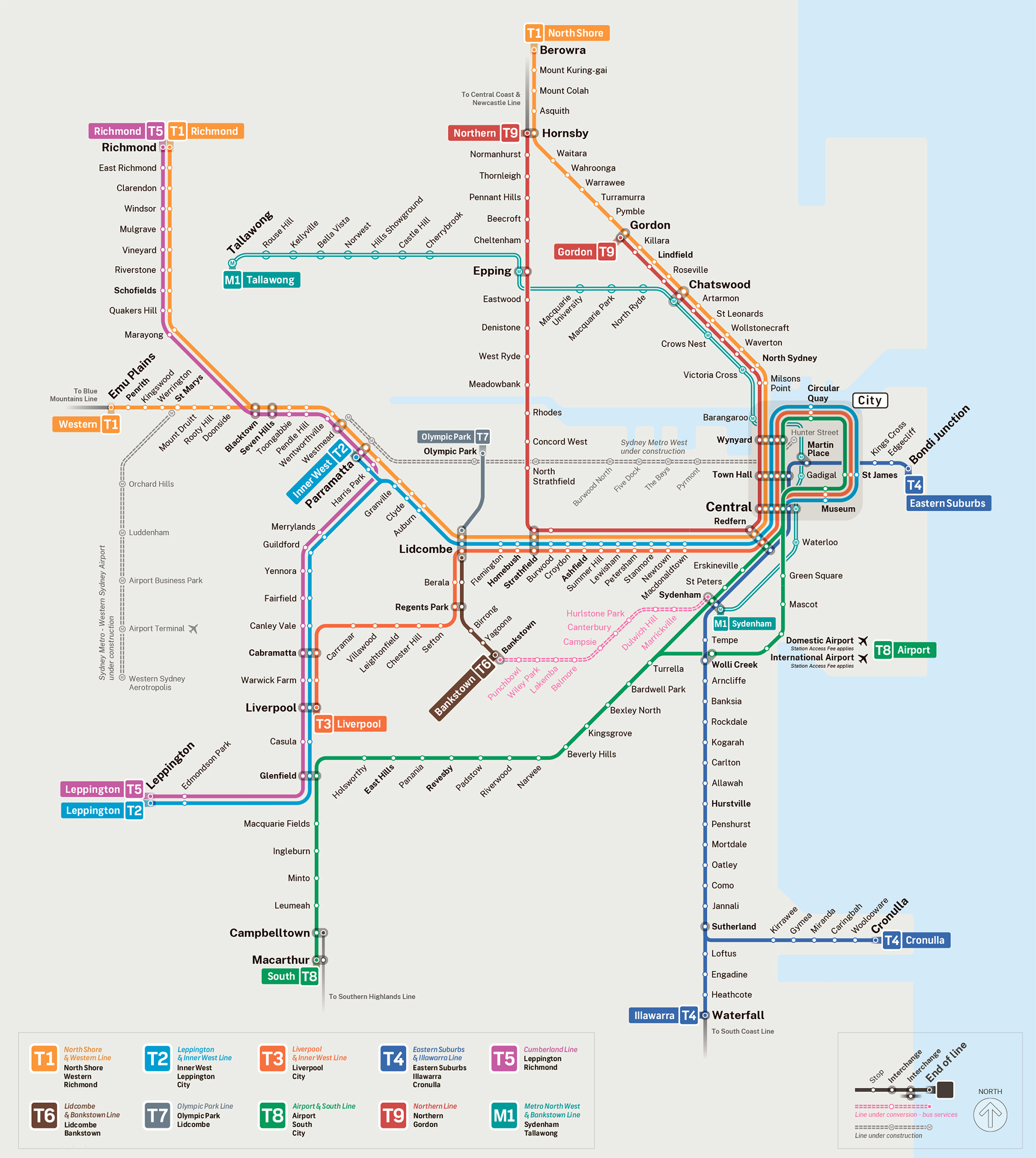
Sydney Metro Map
Map of Sydney Metro showing different lines. Click on the map to enlarge it or download the Sydney Metro map in PDF format.
Lines and Stations
Spanning 815 kilometres (506 miles) with 178 stations, Sydney Trains connects Sydney’s urban and suburban areas. In 2017, it carried approximately 340 million passengers, highlighting its importance to the city’s residents.
The system consists of 8 commercial lines that connect the city centre with various surrounding suburbs.
(T1) North Shore Line, Northern & Western
The T1 line, shown in yellow on system maps, serves Sydney’s northern and western suburbs. Major communities along this line include Blacktown, Perinth, Chatswood, Parramatta, Hornsby and the Central Business District.
As this is not a metro-only system, there is no single line and trains pass through a number of stations.
(T2) Inner West & Leppington Line
Identified by its light blue colour and the designation T2 on system maps, this line serves the western and south-western regions of Sydney as well as the city centre. Key areas served include the Central Business District, Haymarket, Ashfield, Granville, Parramatta, Warwick Farm and Glenfield.
There are 37 stations in all on this line, many of which connect with other Sydney Trains lines.
(T3) Bankstown Line
Identified by the colour orange and the number T3 on system maps, this line serves the Canterbury-Bankstown suburb, the Inner West area and the Western Sydney region.
It starts in part of the Central Business District and later passes through the suburbs of Sydenham, Dulwich Hill, Bankstown, Berala, Carramar and Liverpool. There are a total of 33 stops on this line, many of which connect with other lines in the system.
(T4) Eastern Suburbs & Illawarra Line
One of the oldest lines in the system, dating back to 1880, serves Sydney’s eastern and southern suburbs. It is identified by its azure blue colour and the number T4 on train maps.
The line has 33 stops, with a branch at Sutherland Station. Some trains branch off to suburbs such as Kirrawee, Caringbah and Cronulla in the south of the city, while others branch off to Sydney’s south-eastern suburbs such as Engadine, Heathcote and Waterfall.
(T5) Cumberland Line
The T5 line, shown in magenta on maps, serves residents in Sydney’s western suburbs, including Richmond, Mulgrave, Toongabbie, Guildford, Casula and neighbouring communities.
With 23 stops, each station has been designed with a specific community in mind, creating a circular line that traverses 23 unique western Sydney suburbs.
(T6) Carlingford Line
Despite its long history dating back to 1888, the T6 is Sydney Trains’ smallest line, with only 7 commercial stops.
It runs north to south through the city, covering suburbs such as Rosehill, Camellia, Dundas and Telopea. It is marked on train maps by the colour purple and the number T6. This line is so short that a journey from one end to the other takes just 12 minutes.
(T7) Olympic Park line
Created exclusively to link residents with the Olympic Village structures of the 2000 Olympic Games, the T7 line is now rarely used. Its route is only 7 kilometres (4.3 miles) long and has only one terminus.
It can be identified on maps by the grey colour and the number T7.
(T8) Airport & South Line
Identified by the number T8 and the colour green, this is the newest line in the system. It connects residents in Sydney’s south-west to the city centre.
With a total of 32 stops, including a station dedicated to the airport, the T8 is one of the few Sydney Trains lines to reach the airport terminal. It also serves the suburbs of Beverly Hills, Glenfield, Padstow and Bexley North, as well as the southern part of the city.
Interconnections
Sydney Trains’ stations are closely linked with complementary bus services and various lines operating on their routes. Connections for the above stations include:
T1 Line
- Wynyard Station: T2, T3, and T8.
- Town Hall Station: T2, T3, T4, and T8.
- Central Station: T2, T3, T4, and T8. Also links to a light rail station.
- Redfern Station: T2, T3, T4, and T8.
- Burwood Station and Strathfield Station: T2.
- Lidcombe Station: T2 and T3.
- Auburn Station: T2.
- Clyde Station: T2 and T6.
- Granville Station: T2.
- Harris Park Station and Parramatta Station: T2 and T5.
Westmead, Wentworthville, Pendle Hill, Toongabbie, Seven Hills, Blacktown, Marayong, Quakers Hill, and Schofields stations connect to the T5 line.
T2 Line
- Museum Station: T3 and T8.
- St. James Station: T3 and T8.
- Circular Quay Station: T3 and T8.
- Wynyard Station: T1, T3, and T8.
- Town Hall Station: T1, T3, T4, and T8.
- Central Station: T1, T3, T4, and T8. Also provides connection to a light rail line.
- Redfern Station: T1, T3, T4, and T8.
- Burwood Station and Strathfield Station: T1.
- Lidcombe Station: T1 and T3.
- Auburn Station: T1.
- Clyde Station: T1 and T6.
- Granville Station: T1.
- Harris Park Station and Parramatta Station: T1 and T5.
- Cabramatta Station, Warwick Farm Station, and Liverpool Station: T3 and T5.
- Glenfield Station: T5 and T8.
Merrylands, Guildford, Yennora, Fairfield, Canley Vale, Casula, Edmondson Park, and Leppington stations are connected only to the T5 line.
T3 Line
- Town Hall Station: T1, T2, T4, and T8.
- Wynyard Station: T1, T2, and T8.
- Circular Quay Station: T2 and T8.
- St. James Station: T2 and T8.
- Museum Station: T2 and T8.
- Central Station: T1, T2, T4, and T8. Also links to a light rail line.
- Redfern Station: T1, T2, T4, and T8.
- St. Peters Station: T8 (only during peak hours).
- Sydenham Station: T4 and T8 (only during peak hours).
- Lidcombe Station: T1 and T2.
- Cabramatta Station, Warwick Farm Station, and Liverpool Station: T2 and T5.
T4 Line
- Town Hall Station: T1, T2, T3, and T8.
- Central Station (underground): T1, T2, T3, and T8.
- Redfern Station (underground): T1, T2, T3, and T8.
- Sydenham Station: T3 and T8 (only during peak hours).
- Wolli Creek Station: T8.
T5 Line
- Parramatta Station: T1 and T2.
- Harris Park Station: T1 and T2.
- Cabramatta Station: T2 and T3.
- Warwick Farm Station: T2 and T3.
- Liverpool Station: T2 and T3.
- Glenfield Station: T2 and T8.
Schofields, Quakers Hill, Marayong, Blacktown, Seven Hills, Toongabbie, Pendle Hill, Wentworthville, and Westmead stations have connections to the T1 line. Merrylands, Guildford, Yennora, Fairfield, Canley Vale, Casula, Edmondson Park, and Leppington stations also serve trains on the T2 route.
T6 Line
- Clyde Station: T1 and T2.
T8 Line
- Town Hall Station: T1, T2, T3, and T4.
- Wynyard Station: T1, T2, and T3.
- Circular Quay Station: T2 and T3.
- St. James Station: T2 and T3.
- Museum Station: T2 and T3.
- Central Station: T1, T2, T3, and T4.
- Redfern Station (only during peak hours): T1, T2, T3, and T4.
- St. Peters Station (only during peak hours): T3.
- Sydenham Station (only during peak hours): T3 and T4.
- Wolli Creek Station: T4.
- Glenfield Station: T2 and T5.
Operating Hours
Each Sydney Trains route operates to a specific timetable and the number of trains varies throughout the day. This information can be found on the official website. However, general operating hours start at 4:00am and usually end at 1:00am.
There are exceptions, with some trains running earlier or later. Exact times are published online.
The frequency of trains depends on the time of day. During normal hours, trains leave the platform every 6-8 minutes, increasing to every 3-5 minutes at peak times.
Fares
Since 2014, Sydney’s train system has used a reloadable Opal card for payment. The fare is based on the distance a passenger travels.
There are different types of Opal cards for different types of passengers. The most recent are as follows:
Adult Opal Card: This standard card is meant for passengers over 16 years of age. The fare structure is as follows:
- 0-10 km: 3.46 AUD
- 10-20 km: 4.30 AUD
- 20-35 km: 4.94 AUD
- 35-65 km: 6.61 AUD
Child/Youth Opal Card: This card is for children and youth, aged 4-15, and full-time students aged 16.
- 0-10 km: 1.73 AUD
- 10-20 km: 2.15 AUD
- 20-35 km: 2.47 AUD
- 35-65 km: 3.30 AUD
Gold Senior/Pensioner Opal Card: This card is designed for senior citizens over the age of 65.
- 0-10 km: 1.73 AUD
- 10-20 km: 2.15 AUD
- 20-35 km: 2.47 AUD
- 35-65 km: 2.50 AUD
Concession Opal Card: This card benefits participants of registered concession programs. More information on these programs can be found on the opal.com.au website.
- 0-10 km: 1.73 AUD
- 10-20 km: 2.15 AUD
- 20-35 km: 2.47 AUD
- 35-65 km: 3.30 AUD
Opal Single Trip Tickets: These traditional tickets can be bought from ticket machines at the stations. They can only be used once, and their price is based on the distance of travel.
- 0-10 km: 4.20 AUD (adults), 2.10 AUD (children and youth)
- 10-20 km: 5.20 AUD (adults), 2.60 AUD (children and youth)
- 20-35 km: 6.00 AUD (adults), 3.00 AUD (children and youth)
- 35-65 km: 8.00 AUD (adults), 4.00 AUD (children and youth)
Regulations
- Only guide dogs and police dogs are allowed on trains.
- The carrying of open bottles and the consumption of alcohol on trains and at stations is prohibited.
- Persons under the influence of alcohol or displaying violent or inappropriate behaviour will be removed from train premises.
- All toxic substances, flammable materials and potentially dangerous objects are prohibited in stations and on trains.
- Supermarket trolleys are not allowed on train premises.
- Smoking, including electronic cigarettes, is not allowed in any metro facility.
- Bicycles are allowed on the train at all times, but must not obstruct the movement of passengers within the facilities.
- Reserved areas are available for people with reduced mobility in stations and on trains.
- Passengers should keep to the left on escalators to allow others to pass on the right.
- Feet on train seats are prohibited.
- Passengers should avoid getting on or off the train after the announcement of the closing of the doors.
- Seats reserved for the elderly, disabled or pregnant women should not be occupied by others.
Connection to the Airport
Sydney’s Kingsford Smith International Airport has a metro station at each of its two terminals (domestic and international), connecting passengers to the city centre and surrounding suburbs. Line 8 (T8) is the line to take to get to the airport. Other transport options at the airport include car hire, taxis, bus services and a limousine rental service.
Future Projects
The Sydney Metro is the most important upcoming project. This metro system will commence operations with the opening of Line 1 as one of the two planned lines. The 66 kilometre line with 31 stations will connect Rouse Hill with Chatswood, passing through the central business district.
Tourist Sites
One of Sydney’s most iconic landmarks is the Sydney Opera House, located near Circular Quay Station, which is served by the T2, T3 and T8 lines. Another famous landmark is the Sydney Harbour Bridge, also accessible from Circular Quay Station. Both the Opera House and the Harbour Bridge offer stunning views, especially at night, and are must-sees in the city.