The Amsterdam tram is the city’s tramway network and a core part of public transport in Amsterdam, alongside the metro, bus, and ferries. Its history goes back to 1875, and since 1943 it has been operated by GVB. The system is the largest tram network in the Netherlands, widely used for everyday city transport and especially handy for visitors, as many major sights are reached directly by tram.
| Key | Information |
|---|---|
| Operator | GVB |
| Started | 1875 |
| Current operator since | 1943 |
| Network size | 15 lines |
| Fleet | 227 trams as of 2022 |
| Route length | 95 km / 59 miles of routes |
| Track length | 200 km / 124 miles of standard gauge track |
| Stops | About 500 stops |
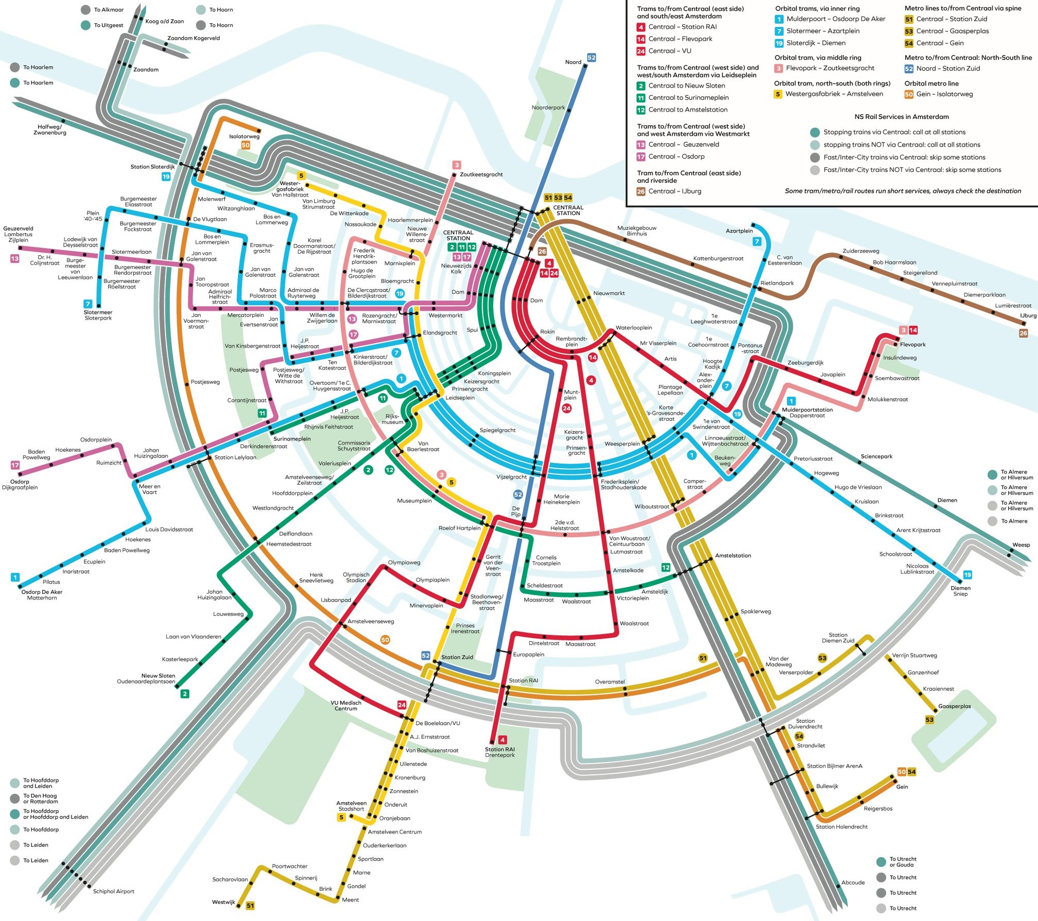
Map of the Amsterdam Tram
The Amsterdam tram map helps you understand the system, compare routes, and plan a practical route through the city. Trams are part of Amsterdam public transport together with the metro, bus network, and ferries, so the stations map is useful not only for tram travel but also for transfers.
GVB operates the network. It has 15 lines, around 500 stops, and about 80.5 km / 50 miles of rail network. For local transport in central Amsterdam, the tram is often one of the easiest options, especially for sightseeing.
The main lines shown on the map are listed below.
| Station | Details |
|---|---|
| Line 1 | Centraal Station ↔ Osdorp De Aker |
| Line 2 | Centraal Station ↔ Nieuw Sloten |
| Line 3 | Zoutkeetsgracht ↔ Muiderpoortstation |
| Line 4 | Centraal Station ↔ Station RAI |
| Line 5 | Centraal Station ↔ Amstelveen Binnenhof |
| Line 7 | Slotermeer ↔ Flevopark |
| Line 9 | Centraal Station ↔ Diemen Sniep |
| Line 10 | Westerpark ↔ Azartplein |
| Line 12 | Station Sloterdijk ↔ Amstelstation |
| Line 13 | Centraal Station ↔ Geuzenveld |
| Line 14 | Slotermeer ↔ Flevopark |
| Line 16 | Centraal Station ↔ VU Medisch Centrum |
| Line 17 | Centraal Station ↔ Osdorp Dijkgraafplein |
| Line 24 | Centraal Station ↔ VU Medisch Centrum |
| Line 26 | Centraal Station ↔ IJburg |
Several routes start from Centraal Station, which makes it a natural starting point for a route plan. If you are choosing between hotels, museums, or canal-area stops, the map quickly shows which path train or tram route fits best.
For many visitors, line 2 is one of the most useful routes. Other central lines also give easy access to major attractions and museum areas. If you are planning transfers, the stations list on the map also shows where tram connections meet metro and rail services.
Check the map before you travel. It saves time once you arrive and makes the whole system easier to read.
Map of Amsterdam Trams showing different lines and stations. Click on the map to enlarge it or download the Amsterdam Trams map in PDF format.
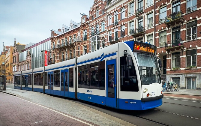
Amsterdam Tram Routes
The Amsterdam tram route network is extensive and practical. It runs through the historic center, along canals, and out to residential districts, so for many trips it is one of the easiest ways to move around the city.
The system has grown since 1875 and today includes 15 lines and about 200 km / 124 miles of rail lines. GVB operates the tramway as part of the wider city transport system that also includes the metro, buses, and ferries.
Useful routes for visitors
- Line 2 is especially popular for sightseeing. Stops along the route give access to the flower market, the Royal Palace on Dam Square, the Rijksmuseum, the Van Gogh Museum, and the Stedelijk Museum.
- Lines 1, 2, and 5 are useful for central attractions such as Dam Square, Spui, Amsterdam Museum, and Begijnhof, with lines 2 and 5 continuing toward the Rijksmuseum and Van Gogh Museum.
- Lines 13 and 17 are handy for Westerkerk, Westermarkt, and the Anne Frank House.
- Line 26 links Centraal Station with IJburg via Rietlandpark and the Piet Hein Tunnel.
Current tram lines
| Station | Details |
|---|---|
| Line 1 | Muiderpoortstation – Osdorp De Aker (Matterhorn) |
| Line 2 | Centraal Station – Nieuw Sloten (Oudenaardeplantsoen) |
| Line 3 | Zoutkeetsgracht – Flevopark |
| Line 4 | Centraal Station – Station RAI (Drentepark) |
| Line 5 | Westergasfabriek (Van Hallstraat) – Stadshart Amstelveen |
| Line 7 | Slotermeer (Sloterpark) – Azartplein |
| Line 12 | Centraal Station – Amstelstation |
| Line 13 | Centraal Station – Geuzenveld (Lambertus Zijlplein) |
| Line 14 | Centraal Station – Flevopark |
| Line 17 | Centraal Station – Osdorp Dijkgraafplein |
| Line 19 | Station Sloterdijk – Diemen Sniep |
| Line 24 | Centraal Station – VU medisch centrum (De Boelelaan/VU) |
| Line 25 | Station Zuid – Amstelveen Westwijk |
| Line 26 | Centraal Station – IJburg (Pampuslaan) |
| Line 27 | Surinameplein – Osdorp Dijkgraafplein |
There are direct transfers between metro and tram at 17 stations, which makes cross-city transport easier to plan. Some tram stops also connect with the national railway network, useful for regional travel.
Passenger tips
- Enter at the front door by the driver or at the double doors at the back. Other doors are exit only.
- Only doors marked with the Welkom sticker are for boarding.
- Validate your ticket after boarding.
- You need a valid ticket for every ride.
Trams also work well for scenic travel. Compared with the metro, you see much more of the city during the running time, and the dense route network makes museums and central sights easy to reach.
Upcoming route changes are already announced for 29 March 2026: line 25 will be extended from Amsterdam Zuid Station to Muiderpoort Station, and line 24 will approach Centraal Station via Leidseplein instead of Ferdinand Bolstraat.
Amsterdam Tram Fares and Tickets
Amsterdam trams use the same fare system as the metro and city bus network. For many visitors, the simplest ticket option is a GVB day pass or multi-day pass, since it allows unlimited travel on GVB trams, buses, and metro during the validity period.
Single rides can also be paid with an OV-chipkaart or with OVpay. With OVpay, you check in and out using the same contactless debit or credit card, and the fare is charged automatically. A 1-hour GVB ticket is available too, though a day pass is often better value if you plan several trips.
- GVB day and multi-day tickets: unlimited travel on GVB trams, buses, and metro for 1 to 7 days
- OVpay: pay per ride with a contactless bank card
- OV-chipkaart / e-purse: reloadable card for distance-based fare payment
- GVB 1-hour ticket: valid for 60 minutes on GVB transport
For sightseeing, a GVB day pass is usually the most convenient choice because you can hop on and off without paying each time. That is especially useful on popular visitor routes such as line 2.
If you prefer to buy ahead, GVB day and multi-day tickets can be purchased online before your trip. That can save time after arrival.
Children aged 0 to 3 travel free on Amsterdam public transport. A reduced GVB day ticket is available for children aged 4 to 11.
If your plans include the airport or travel beyond the city, there are also combined passes such as the Amsterdam Travel Ticket and the Amsterdam & Region Travel Ticket. These include tram travel, but they are intended for different kinds of journeys than a standard city ticket.
Amsterdam Tram Timings and Schedule
Amsterdam trams run every day and are a reliable part of city transportation. They connect well with buses, the metro, and trains, which makes them useful both for short central rides and for transfers across the wider public transport system.
In general, operating hours start around 6 am on weekdays and around 7 am on weekends. Services continue until just after midnight, so the opening hours are early enough for most daily trips, but trams do not run 24 hours a day.
During the day, frequency is usually about 5 to 8 trams per hour, depending on the line. In the evening and on weekends, that usually drops to around 3 to 4 per hour. So if you are checking timings today or schedule today, waits are usually short.
| Service detail | Timings |
|---|---|
| Weekday starting time | Around 6:00 am |
| Weekend starting time | Around 7:00 am |
| Closing time | Just after midnight |
| Daytime frequency | About 5 to 8 services per hour |
| Evening and weekend frequency | About 3 to 4 services per hour |
| Last train / last tram from Centraal Station | Shortly after midnight |
Timetable information and train schedule displays are available at tram stops, where electronic boards show the next departures. You can also check the timetable, route timetable, and live schedule in the GVB app, on GVB’s website, and through 9292. Live timings are also available in Google Maps, Apple Maps, and Citymapper.
Occasional maintenance can cause diversions, so it is worth checking live timetable information before a specific trip. Trams are comfortable and frequent, but for longer cross-city journeys the metro can sometimes be faster because tram route running time is affected by stops, traffic, and signals.
If you are planning a late return, note that the last train or last tram from Centraal Station leaves shortly after midnight. After trams close for the night, night buses continue from Centraal Station.
Interconnections with Other Systems
Amsterdam’s tram network is closely integrated with the wider public transport system. Because GVB also runs the metro, city bus services, and ferries, transfers between different forms of local transport are fairly straightforward.
The strongest interconnections are with the metro. Since metro line 52 opened in 2018, network planning has placed more emphasis on metro travel for longer cross-city trips, with tram and bus routes feeding into it. There are direct tram-to-metro transfers at 17 stations.
Some routes are particularly important here. Tram line 5 connects with the metro at Station Zuid. After the southern section of former line 51 was replaced by the Amsteltram, passengers traveling between Amstelveen and the metro network have transferred at Zuid Station. Tram line 25 also plays a key role, linking Station Zuid with Amstelveen Westwijk.
Several tram lines also connect with the national railway network at places such as Centraal Station, Amstelstation, Station Zuid, and Station Lelylaan. These interchange points make it easier to combine city transport with regional or intercity travel.
Network planning continues to adapt. After the North–South metro line opened, line 19 was reintroduced as a combination of former tram routes, and line 11 returned as a supplementary service. Former line 3 is being split among lines 7, 24, and 25, with a transfer between lines 12 and 25 available at De Pijp.
The system is also being updated technically. In 2022, a Hanning & Kahl 3-way point-setting system was installed at Centraal Station to direct trams on routes 4, 14, and 24 to the correct track in stand A. GVB and the regional transport authority are also planning a voltage conversion from 600 to 750 volts to improve efficiency, reduce outages, and support larger trams.
Tips and Rules
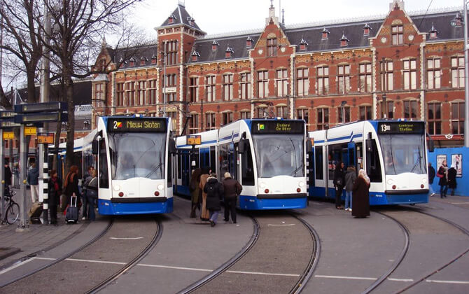
Amsterdam trams are easy to use, and services run frequently from many parts of the city. Quite a few routes start at Centraal Station, so getting going is usually simple.
Buy your ticket before boarding. You can use physical ticket sales points near major stations, contactless card payment, or the GVB app.
Use the GVB app for route planning, live schedule updates, and train schedule information. It is especially helpful if you want to check timings, route options, or service changes in advance.
Follow the boarding rules. On some trams, entry is through the front or middle doors depending on the signs. Once inside, move away from the middle area so others can board. Press the red button when you want to get off. If the doors need to be opened after the tram stops, press the green button.
Listen to the conductor when present. They may ask passengers to move inside or share useful travel information.
Accessibility is built into the system. All Amsterdam trams have designated wheelchair space and priority seating, and some stops are marked as wheelchair accessible in route planners.
For sightseeing, line 2 is one of the best-known routes. It passes several major sights, and the ride itself can be enjoyable thanks to views of canals and central streets.
Families may find tram travel convenient too, since many trams have designated stroller areas.
History
The Amsterdam tram dates back to 1875 and is now operated by GVB, which has also run the city’s metro, bus, and ferry services since 1943. It is the largest tramway system in the Netherlands and one of the largest in Europe.
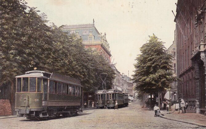
Beginnings
On 3 June 1875, Amsterdam’s first horse-drawn tramway opened between Plantage and Leidseplein. It was operated by AOM, the Amsterdamsche Omnibus Maatschappij, founded in 1872 by Karel Herman Schadd and others. In the late 19th century, horse trams spread through the city’s main streets, linking neighborhoods inside the Singel with Dam Square and reaching newly built residential areas. By the end of the century, about 15 lines served areas including Vondelstraat, Overtoom, Willemsparkweg, Amsteldijk, Linnaeusstraat, Weesperzijde, Bilderdijkstraat, and Ceintuurbaan. Several of those early routes can still be recognized in later lines 1, 2, 3, 4, 7, 9, 10, and 13.
Gemeentetram
On 1 January 1900, the municipality took over AOM and continued the company as Gemeentetram Amsterdam. The takeover included 242 tramcars, 758 horses, and 15 buildings. Electric service began on 14 August 1900 on what became line 10, and by 1906 all but one line had been electrified. The former horse-tram network was also converted from 1,422 mm gauge to standard gauge. By 1906, the electric system had 12 lines and 229 new electric tramcars. The last horse-tram line, line 12 between Nassauplein and Sloterdijk, was electrified in 1916. After Amsterdam annexed Sloten in 1921, the former Sloten horse tramway was taken over by GTA; its horses were replaced by tram-hauling buses in 1922, and the route became a regular bus line in 1925.
Further developments
Between 1910 and 1930, the growing city brought many extensions. New lines included 14 in 1910, 15 to 18 in 1913, 19 in 1916, 22 and 23 in 1921, 20 in 1922, 21 in 1928, 24 in 1929, and 25 in 1930. In 1931, the network reached its greatest extent with 25 tram lines, and by 1940 almost every district could be reached by tram. The fleet grew to 445 motorized trams and around 350 trailers, all twin-axle vehicles with wooden bodies.
From 1922 until 1971, trams carried mailboxes at the rear. These were emptied at Centraal Station, helping late letters reach the post on time. During the Great Depression, service was reduced and lines 12, 15, 19, 20, and 21 were abandoned in 1932. New routes returned in 1939 to 1942 as part of the Eastern Railway Works, serving Amsterdam-Oost, Watergraafsmeer, the new Amstel station, and the rebuilt Muiderpoort station. On 1 January 1943, GTA merged with the Gemeenteveren to form GVB.
During World War II, the network was heavily strained. Several lines were suspended, and in October 1944 the entire tram system stopped because of a coal shortage. Many tram cars were transported eastward.
Postwar period
Service resumed in June 1945 with a limited network including lines 1, 3, 5, 7, 9, 10, 12, 13, 16, 24, and 25. Line 5 was split into lines 5 and 12. Lines 2, 17, and 18 returned in 1947, and line 4 in 1948. The emergency line 26 briefly carried the highest number in the system, and a special tram S ran as an express service between line 25 and Amstel station in 1948 and 1949.
Lines 6 and 23 did not return to regular service, though they were used from time to time until 1958 for stadium transport. Lines 8, 14, and 22 were not reactivated as tram lines, although line 22 later returned as a bus line. Between 1948 and 1950, GVB acquired sixty motorized trams and fifty trailers, known as the three-axle trams, built by Werkspoor in Utrecht-Zuilen. These replaced the oldest vehicles in the fleet, which had entered service in 1902.
After postwar reconstruction, several tram routes were gradually replaced by buses in the 1950s and early 1960s. Lines 18, 12, 11, 17, and 5 were replaced in that order. Only Leidsestraat and Utrechtsestraat kept tram service, because buses were too large for those narrow streets.
Revival and expansion
In the mid-1950s, modern tramcars helped secure the future of the system. The 25 articulated trams ordered in 1955 for lines 1 and 2 were well received. Between 1957 and 1968, 160 more articulated vehicles built by Beijnes and Werkspoor were added, while the old prewar twin-axle trams were withdrawn.
As tram travel regained favor, the Western Garden Cities in the west of Amsterdam were connected to the network: Bos en Lommerplein in 1950, Slotermeer in 1954, and Osdorp in 1962. More changes followed, including the return of line 17 in 1962, the appearance of line 27 on the old line 17 route, the extension of line 1 to Osdorp in 1971, and the opening of line 14 to Station Sloterdijk in 1982. New connections also opened to Geuzenveld, Slotervaart-Zuid, Nieuw Sloten, and De Aker, as well as links to Station Zuid, Flevopark, Station RAI, and Station Sloterdijk.
In the 1970s, the first articulated trams were lengthened with a middle section to become bi-articulated trams, and new series were ordered from Linke-Hofmann-Busch in Germany. By the early 1980s, GVB had 252 bi-articulated trams in service, then the highest number in any European city. The three-axle trams made their last runs in 1983.
New technology and recent changes
In 1989 to 1991, 45 articulated vehicles built by BN in Bruges were delivered to replace older trams and work new routes. These were Amsterdam’s first partly low-floor trams. In 1990, the new tramway to Buitenveldert and Amstelveen opened, with line 5 to Amstelveen Binnenhof and light rail line 51 to Amstelveen Poortwachter, later extended to Westwijk in 2004. Line 9 was extended to Diemen in 1990, and several special or short-lived lines followed in the 1990s.
Between 2002 and 2004, GVB received 155 Siemens Combino trams, including four bidirectional vehicles for line 5. By mid-2004, the full order had been delivered and the last old articulated cars from the 1960s were withdrawn. However, all Combinos were later taken out of service gradually between 2004 and 2008 for repairs and strengthening because of structural faults.
From 2001 to 2016, the network kept changing. Line 1 was extended to De Aker in 2001, line 6 was diverted to Centraal Station in 2002, line 16 was extended to VU Medisch Centrum in 2003, line 10 was extended to Java-eiland in 2004, and line 24 reached VU Medisch Centrum in 2006. In 2011, a new turning loop for lines 16 and 24 opened at De Boelelaan/VU.
Since 2017
When metro line 52, the North–South line, opened on 22 July 2018, the tram network was reorganized to encourage longer cross-city trips by metro with transfers to tram and bus services. The result was a network of 14 tram lines, with fewer trams through parts of the city center and Amsterdam-Zuid, and more service around the center. The route between Leidseplein, Weteringschans, Sarphatistraat, and Weesperplein became the busiest tram corridor.
A rush-hour line 6 returned in May 2019 between Amsterdam Zuid station and Amstelveen Stadshart, but it was discontinued in November 2020 because of low ridership. In June 2021, GVB retired its remaining 11G and 12G BN trams, donating one of each type to the Electrische Museumtramlijn Amsterdam. In December 2021, line 27 started running during the morning rush hour between Dijkgraafplein and Surinameplein, supplementing line 17.
In 2024, GVB and the regional transport authority began planning a conversion of the tram system from 600 to 750 volts, aiming to improve energy efficiency, lower costs, reduce outages, and support larger trams in the future.
Future Extensions
Amsterdam’s tram network continues to evolve alongside the city’s growth and transport priorities. Expansion plans and route changes are already part of the official agenda.
One confirmed project is the extension of tram line 26, which will serve new eastern areas of the city. According to the available information, the line is due to reach a newly reclaimed island and is expected to open by the end of 2025, with a further extension planned for around 2035.
Another major project is the planned voltage conversion from 600 to 750 volts. GVB and the regional transport authority are working on this upgrade to improve energy efficiency, reduce energy costs, prevent outages when many trams are operating, and support larger vehicles.
Further route changes are planned from 29 March 2026. Line 25 will be extended northeast from Amsterdam Zuid Station to Muiderpoort Station, line 24 will approach Centraal Station via Leidseplein instead of Ferdinand Bolstraat, and line 3 will disappear, with its route split among lines 7, 24, and 25. Transfers between lines 12 and 25 will be possible at De Pijp.
These changes show that the tram system remains a central part of Amsterdam’s long-term public transport strategy.
Nearby Attractions

Amsterdam trams are one of the simplest ways to reach many of the city’s best-known attractions. They run through the center and out to nearby neighborhoods, so you can combine sightseeing with regular city transport without much effort.
One of the most useful corridors for visitors runs from Centraal Station through the city center toward Leidseplein and the museum district. Trams 1, 2, and 5 serve this stretch frequently, with several convenient stops along the route.
| Station | Details |
|---|---|
| Dam | Close to Dam Square and within reach of the Anne Frank House |
| Spui | Useful for the Amsterdam History Museum, Begijnhof, bookstores, and the Nine Streets |
| Koningsplein | Near the flower market and Mint Tower |
| Leidseplein | Lively area for nightlife, theaters, and concert venues, with access toward Vondelpark and the museum zone |
| Rijksmuseum | Gateway to the museum district |
| Van Baerlestraat | Useful for the Van Gogh Museum and the Stedelijk Museum |
If you start at Centraal Station, the tram also passes places such as Damrak, the Red Light District, and the free ferry across the IJ. For first-time visitors, that makes the tram both practical and enjoyable.
Because stops are close together and frequency is good, you can hop off, explore, and continue your route without much waiting.