The Amsterdam Metro is a rapid transit system in Amsterdam, Netherlands, and a core part of the city’s public transport network. Opened in 1977 and operated by GVB, it works alongside trams, buses, ferries, and NS trains to connect the historic center with residential districts, business areas, and nearby municipalities. The system has five lines, 39 stations, and a network length of about 52 km (32.3 miles). Four lines serve or terminate at Amsterdam Centraal, while Line 50 provides an orbital route that bypasses the city center.
| Key | Information |
|---|---|
| System | Amsterdam Metro (Amsterdamse metro) |
| Operator | GVB |
| Owner | City of Amsterdam |
| Opened | 1977 |
| Lines | 5 |
| Stations | 39 |
| Network length | About 52 km (32.3 miles) |
| Main hub | Amsterdam Centraal |
| Typical operating hours | Around 06:00 to 00:30 daily |
| Ticketing | Integrated with GVB tram, bus, and ferry services |
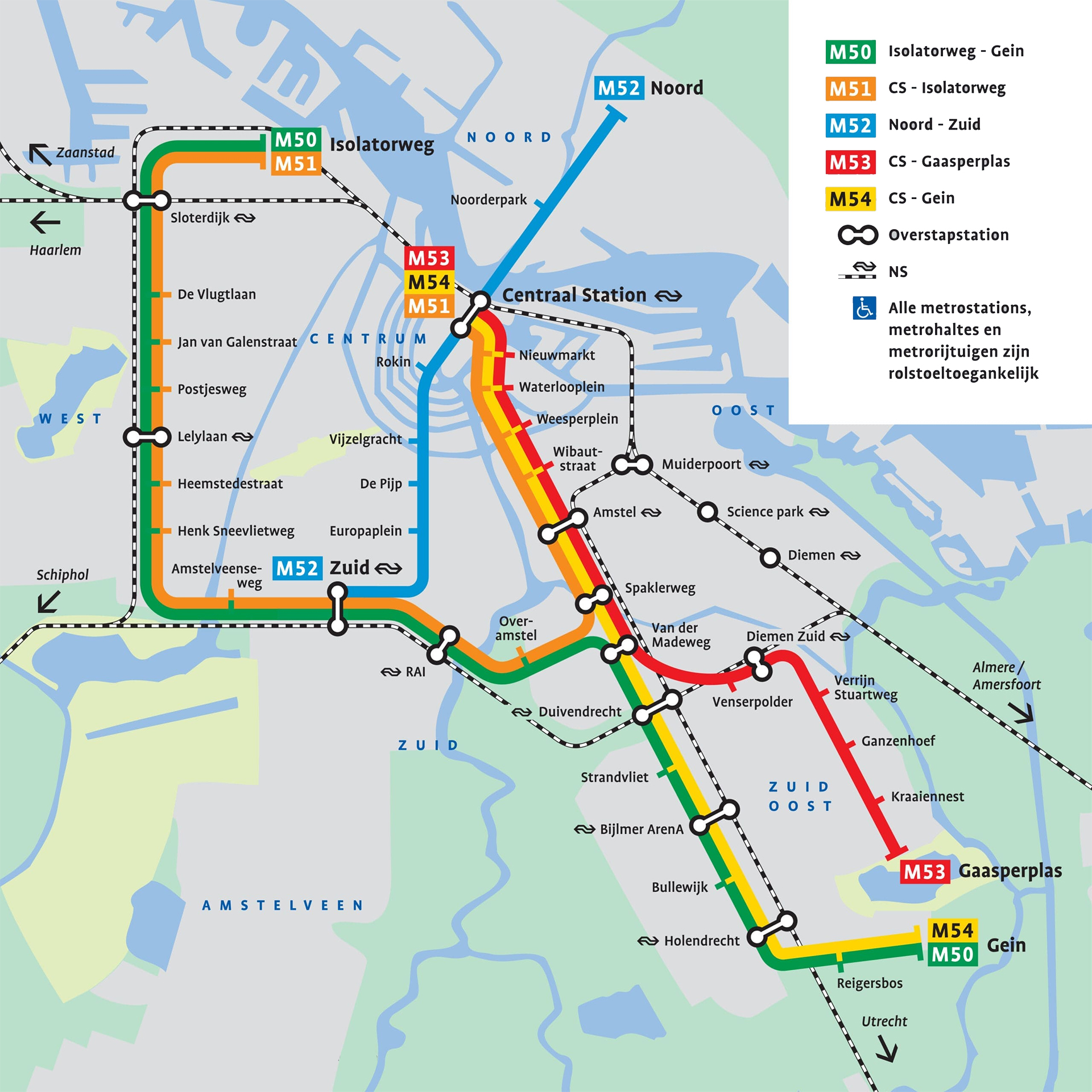
Amsterdam Metro Map
Map of Amsterdam Metro showing different lines and stations. Click on the map to enlarge it or download the Amsterdam Metro map in PDF format.
Lines and Stations
The Amsterdam Metro system has five lines and 39 stations. For most travelers, the route plan is easy to follow: four lines connect with Amsterdam Centraal, while Line 50 acts as the one path train route that skirts the center. The network serves major business districts, key rail interchanges, and many outer residential areas, with tram and bus links filling the gaps where the metro does not reach.
Current routes are listed below.
| Station | Details |
|---|---|
| Line 50 | Isolatorweg – Gein. Uses Ringlijn infrastructure opened in 1997 together with part of the East Line. Runs on viaducts and embankments and has no level crossings. |
| Line 51 | Isolatorweg – Centraal. Originally a hybrid metro-tram route to Amstelveen, it became a full metro line in 2019 after the southern section was converted to the Amsteltram. |
| Line 52 | Noord – Zuid. Opened in 2018, this deep-level route links Amsterdam-Noord with Amsterdam-Zuid via Centraal, running under the IJ and the historic center. |
| Line 53 | Gaasperplas – Centraal. Shares the Oostlijn trunk through the inner city, then branches southeast to Gaasperplas. |
| Line 54 | Gein – Centraal. Follows the Oostlijn trunk and continues via Holendrecht to Gein, serving southeastern districts around Bijlmermeer. |
Lines 51, 53, and 54 share tracks and platforms between Centraal and Amstel, which gives this corridor high frequency and simple transfers. Handy central stations on this stretch include Nieuwmarkt for Chinatown, Waterlooplein for the market area and cultural institutions, and Wibautstraat for hotels and nightlife. Line 54 continues to Amsterdam-Zuidoost, serving places such as Bijlmer ArenA and Bullewijk.
Line 52 adds the north-south spine many visitors use most. Key stops include Noord, with bus links to the Waterland villages, Rokin for Dam Square and Spui, Vijzelgracht for the museum district, De Pijp for Albert Cuyp Market, and Europaplein for the RAI convention center.
Network overview
| Route | Line(s) used | Termini | Opening year | Length km (mi) | Stations | Daily ridership (2019 avg.) |
|---|---|---|---|---|---|---|
| 50 | Ring, East (South branch) | Isolatorweg – Gein | 1997 | 20.1 (12.5) | 20 | 100,200 |
| 51 | Ring, East | Isolatorweg – Centraal | 1990 | 19.5 (12.1) | 19 | 60,800 |
| 52 | North–South | Noord – Zuid | 2018 | 9.5 (5.9) | 8 | 84,000 |
| 53 | East (East branch) | Gaasperplas – Centraal | 1977 | 11.3 (7.0) | 14 | 60,600 |
| 54 | East (South branch) | Gein – Centraal | 1977 | 12.1 (7.5) | 15 | 73,500 |
The stations map is fairly intuitive because many station names match well-known neighborhoods or landmarks. That makes the stations list easier to read, even for first-time visitors.
Future changes and extensions
From December 2027, Line 53 is planned to be discontinued. Line 50 will be rerouted from Isolatorweg – Gein to Isolatorweg – Gaasperplas. Between Van der Madeweg and Gaasperplas, Line 50 will take over the current Line 53 route. Between Van der Madeweg and Gein, only Line 54 will remain, making Van der Madeweg an even more important transfer station.
Longer term, several expansion ideas remain under discussion. These include extending Line 52 south toward Amsterdam Airport Schiphol and Hoofddorp, as well as broader regional links toward places such as Zaandam and Purmerend. A structural box for a future underground station at Sixhaven has already been built between Noorderpark and Centraal on Line 52.
Schedule and Frequency
The Amsterdam Metro runs every day, with opening hours generally from around 06:00 until about 00:30. These operating hours usually apply on weekdays, weekends, and public holidays, though some services may finish a little earlier or a bit later depending on the line. If you are checking timings today or need the exact closing time for a specific route, it is best to confirm the current train schedule before you travel.
| Service detail | Timings |
|---|---|
| Starting time | Around 06:00 daily |
| Last train / closing time | About 00:30, with some services continuing close to 01:00 |
| Typical daytime frequency | Usually every 10 minutes on most routes |
| Late evening and start/end of service | Intervals can be slightly longer |
| Rush hours | Monday to Friday, 07:00-09:00 and 16:00-18:30 |
| Night transport after metro close | Night bus services operate on key routes |
| Major holidays | Usually Sunday timetable |
For everyday travel, trains usually come every 10 minutes during the day. The frequency can be lower early in the morning, late in the evening, or near the end of service. So if you need the exact timetable, route timetable, or schedule today, check a live planner shortly before you leave.
Rush hours in Amsterdam public transport are Monday to Friday from 07:00 to 09:00 and from 16:00 to 18:30. At these times trains are busier, and bicycles are not allowed on the metro. Outside peak periods, bikes are allowed with an extra ticket.
When the metro stops running, night buses take over many key connections. Around Christmas Day, Boxing Day, and New Year’s Day, the schedule often switches to Sunday timings. New Year’s Eve and 1 January can have special opening times and altered service patterns, so it’s worth checking in advance.
Fees, Tickets, and Cards
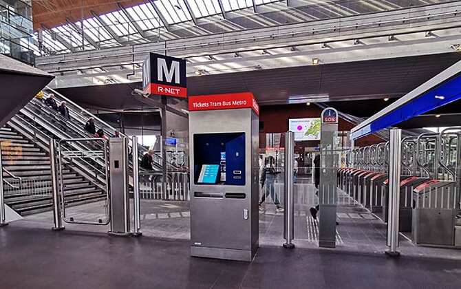
Amsterdam uses an integrated fare system across metro, tram, bus, and ferry services. Every passenger aged 4 or over must have a valid ticket, pass, card, or payment method, and must check in at the start and check out at the end of each trip. For short stays, the main decision is simple: pay per ride, or buy a day pass or multi-day pass.
Pay-per-ride: OVpay and OV-chipkaart
Pay-per-ride works well if you travel only occasionally or stay longer and do not need unlimited rides. The fare is based on a boarding fee plus a per-kilometer charge, but the draft does not provide the exact current base fare and per-kilometer price.
- OVpay: Check in and out with a contactless bank card, credit card, or phone. No registration is required. Use the same card or device for both taps so the correct fare is charged.
- GVB Max daily cap: When using OVpay on GVB services, total daily cost is capped at €10.00 ($10.89).
- OV-chipkaart: A reloadable smart card used across Amsterdam and the Netherlands on metro, tram, and bus, with distance-based pricing.
If you want a simple fare calculator approach, OVpay is the easiest option for occasional use because the system calculates the cost automatically.
GVB day and multi-day tickets
For many visitors, these tickets are the easiest and often cheapest choice. They give unlimited travel on GVB metro, tram, bus, and night bus services within Amsterdam, regardless of distance.
- Validity: Available from 24 hours to 168 hours. The pass starts at first check-in and runs continuously.
- Ticket price: 1 day €10 ($10.89); 2 days €16 ($17.42); 3 days €21.50 ($23.41); 4 days €27.50 ($29.94); 5 days €34 ($37.02); 6 days €39 ($42.46); 7 days €43 ($46.82).
- Children: Ages 0-3 travel free. A reduced-price children’s day ticket is available for ages 4-11.
- Coverage: Valid on the full GVB metro, tram, bus, and night bus network in Amsterdam. Not valid on regional bus operators or NS trains.
I amsterdam City Card
This card combines unlimited GVB public transport with free or discounted entry to many attractions. It makes sense if you plan to use city transport a lot and visit several paid sights.
- Transport coverage: Unlimited GVB metro, trams, and city buses for 24, 48, 72, 96, or 120 hours, depending on the card.
- Extras: Free entry to many attractions and museums, plus discounts at others.
- Best for: Visitors who want one card for both transportation and sightseeing.
Amsterdam Travel Ticket and Amsterdam & Region Travel Ticket
These products are useful if your plans include airport transfers or regional travel beyond the core GVB system.
- Amsterdam Travel Ticket: Valid for 1-3 days. Includes unlimited GVB transport in Amsterdam, unlimited second-class NS train travel between Schiphol Airport and Amsterdam stations, plus the Amsterdam Airport Express bus.
- Amsterdam & Region Travel Ticket: Valid for 1-3 days on GVB metro, tram, and bus lines in Amsterdam, plus regional buses and NS trains within the wider metropolitan area.
Choosing the right option
- Light use: OVpay or OV-chipkaart.
- Frequent city travel: GVB 1-7 day ticket.
- Transport plus attractions: I amsterdam City Card.
- Including airport transfer: Amsterdam Travel Ticket.
- Regional day trips: Amsterdam & Region Travel Ticket.
Whichever ticket you choose, remember the basic rule: always check in and check out. In the metro, you do this at station gates or card readers. On trams and buses, use the readers by the doors.
Connections with Other Systems
The Amsterdam Metro is tightly integrated with the wider public transport system. GVB also operates the city’s trams, buses, and ferries, while NS provides regional and intercity rail. Together, they form the backbone of local transport and city transport across Amsterdam and the surrounding area.
Integration with Trams
Trams cover the historic center and inner neighborhoods more densely than the metro, so tramway connections are essential for many everyday trips. In practice, the metro handles longer, faster journeys, while trams provide fine-grained coverage closer to street level.
| Station | Details |
|---|---|
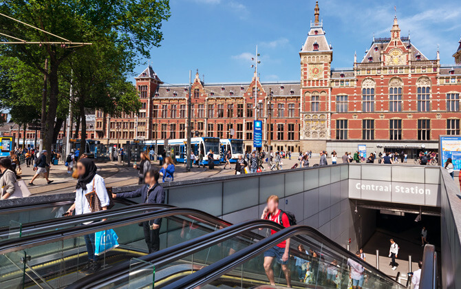
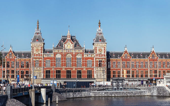
| Amsterdam Centraal Station | Main interchange where multiple tram lines connect with metro Lines 51, 53, and 54. |
| Wibautstraat | Connected by tram Line 3 to metro Lines 51, 53, and 54. |
| Weesperplein | Served by tram Lines 7 and 10 with transfers to metro Lines 51, 53, and 54. |
| De Vlugtlaan | Interchange between Line 50 and tram Line 7. |
| Sloterdijk and Amstelstation | Multimodal hubs where tram Line 12 connects with metro Line 50 at Sloterdijk and Lines 51, 53, and 54 at Amstelstation. |
Historically, Route 51 operated as a hybrid metro-tram line to Amstelveen. Since 2019, that southern section has been converted to tram line 25, with passengers transferring at Zuid.
Bus and Ferry Connections
The bus network feeds many metro stations and extends service to places without rail access. Other operators, including Connexxion, AllGo, R-net, and EBS, also connect suburbs and nearby municipalities to metro and train hubs.
Ferries across the IJ are another useful link, especially between Amsterdam Centraal and Amsterdam-Noord. The busiest ferry runs between Centraal and Buiksloterweg day and night. It pairs well with Line 52, which provides the underground north-south connection.
Connections with National and Regional Trains
The metro connects with NS rail services at several major stations, making transfers easy for commuters and visitors.
| Station | Details |
|---|---|
| Amsterdam Centraal | Main national rail hub with NS domestic services and international trains, plus metro Lines 51, 53, and 54. |
| Amsterdam Amstel | Transfer point between NS rail and metro Routes 53 and 54. |
| Amsterdam Zuid | Major interchange served by metro Routes 50, 51, and 52, plus NS trains. |
| Duivendrecht and Bijlmer ArenA | Additional metro-train connections in Amsterdam-Zuidoost. |
Schiphol Airport is not directly served by the metro yet. For now, the standard route is to use an NS train to Amsterdam Centraal or Amsterdam Zuid and continue from there by metro.
Ticketing and Fare Integration
Ticketing is integrated across most forms of transportation in Amsterdam. The OV-chipkaart works on metro, tram, bus, ferry, and NS trains, and OVpay allows contactless payment on participating services. This unified system makes transfers pretty straightforward, even when you switch between several operators in one day.
Connections to the Airport
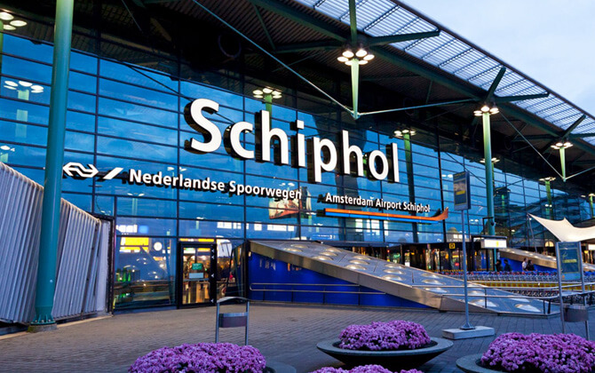
Amsterdam Airport Schiphol is southwest of the city. There is no direct metro route to the airport at present, but the connection is still easy thanks to frequent NS trains, airport buses, taxis, and ride-hailing services. For most travelers, the train is the fastest option.
Fastest options from Schiphol to central Amsterdam
| Method | Typical time / cost | Best for |
|---|---|---|
| NS train to Amsterdam Central | About 13-18 minutes; singles from around €5-6 ($5.44-$6.53) | Most visitors heading to the historic center or onward metro and tram connections |
| NS train to Amsterdam Zuid + Metro line 52 | About 7 minutes to Zuid by train, then metro to the center; around 25 minutes total | Destinations along Line 52, including Europaplein, De Pijp, Vijzelgracht, Rokin, Centraal, and Noord |
| Amsterdam Airport Express Bus 397 | About 28-38 minutes; €6.50 single ($7.08), €11.75 open return ($12.79) | Hotels near Museumplein, Rijksmuseum, Leidseplein, and Elandsgracht |
| Taxi / pre-booked shuttle | Roughly 25-45 minutes; usually €40-80 ($43.56-$87.12) | Door-to-door travel, luggage, late-night arrivals, groups |
| Ride-hailing | Typical city-center fares around €30-65 ($32.67-$70.78) | App-based booking with upfront price |
There is no metro line to Schiphol yet. Plans exist to extend Line 52 to the airport, with completion currently envisaged around 2030.
Using the train between Schiphol and the city
Schiphol has an underground NS station directly beneath the terminal. From arrivals, follow signs to Trains and Schiphol Plaza, then go down to the platforms.
- Frequency: Sprinter and Intercity trains run up to about 8 times per hour to Amsterdam Central, with night service once per hour.
- Running time: Usually 13-17 minutes to Central, around 7 minutes to Zuid.
- Tickets: Available from machines, desks, online, or through OVpay contactless payment.
- Best metro connection: Amsterdam Zuid is the quickest transfer point for Line 52.
Airport Express Bus 397 and other buses
Bus 397 leaves from stop B17 at Schiphol Plaza and is a popular choice for the museum and entertainment districts.
- Route: Schiphol Plaza to Elandsgracht via Museumplein, Rijksmuseum, and Leidseplein.
- Frequency: Roughly every 7.5-8 minutes during the day.
- Night service: Route N97 operates between about 01:00 and 05:00.
- Ticket price: Around €6.50 single ($7.08) or €11.75 open return ($12.79).
GVB bus 369 also connects Schiphol Plaza with Amsterdam Sloterdijk in about 40 minutes, though the train remains much faster for travel to Central.
Combined airport and city tickets
If you plan to use local transport a lot after arriving, combined tickets can save both time and money.
- Amsterdam Travel Ticket: Around €18 ($19.60), €24 ($26.14), and €30 ($32.67) for 1, 2, and 3 days.
- Amsterdam & Region Travel Ticket: Around €21 ($22.87), €31.50 ($34.31), and €40.50 ($44.11) for 1, 2, and 3 days.
- Holland Travel Ticket: A nationwide one-day pass, generally better for longer trips beyond Amsterdam.
These products use the same check-in/check-out logic as other Dutch public transport tickets.
Taxi, shuttles and ride-hailing services
Taxis are available 24/7 outside arrivals. They are comfortable, but much more expensive than rail or bus.
- Taxi fare: Usually €40-80 ($43.56-$87.12), depending on traffic and distance.
- Pre-booked shuttles: Often offer fixed pricing, which can be helpful for groups.
- Ride-hailing: Standard app-based rides usually cost about €30-60 ($32.67-$65.34), with premium options higher.
Use the official taxi rank or reputable pre-booked services. Unofficial offers near the terminal should be avoided.
Paying for public transport to and from Schiphol
- OVpay: Tap in and out with a debit card, credit card, or mobile wallet.
- Single and day tickets: Available from airport machines and ticket desks.
- Visitor passes: Useful if you want airport transfer plus unlimited city transport in one product.
Even without a direct metro link, Schiphol is well connected to Amsterdam by train and bus, with straightforward onward transfers into the metro system.
System Regulations
The Amsterdam Metro is designed to be safe and easy to use. Rules are enforced across stations and trains, and most are exactly what you would expect on a busy urban transport system.
General Behaviour and Conduct
- No smoking in trains or stations.
- No eating or drinking on board.
- No drugs or alcohol during your journey.
- Keep noise down and use headphones.
- Do not put your feet on seats.
Ticketing, Validation and Payments
All passengers aged 4 and above need a valid ticket, card, or payment method.
- You must check in and check out on every trip.
- Failure to check in counts as fare evasion.
- Failure to check out can lead to extra charges.
- OV-chipkaart users need at least €4 ($4.36) credit before boarding local transport.
- Each passenger must use their own card or device.
- With OVpay, always use the same card or phone for both taps.
- GVB OVpay daily cap is €10.00 ($10.89).
Access to Metro Stations
Most metro stations use gated entry.
- Platforms are accessible by tapping in at the gates.
- If there are no barriers at your destination, use the yellow readers to check out.
Rules for Bikes, Strollers and Accessibility
- Bikes are allowed only outside rush hours and require a separate ticket.
- Rush hours are Monday to Friday, 07:00-09:00 and 16:00-18:30.
- Strollers should be placed so aisles and doors stay clear.
- Many stations have lifts and wider gates for wheelchair users.
Safety, Enforcement and Operating Times
- Working hours are generally around 06:00 to 00:30.
- Night bus services run after the metro closes.
- Fare inspections take place, and fines can be issued on the spot.
- Trains and stations are monitored and well lit.
In short: travel with a valid ticket, follow check-in rules, and use common sense. It’s a safe system when used normally.
Tips
The Amsterdam Metro is simple to use, but a few practical habits can save time, money, and stress.
Tickets, payment and check-in
- For one or two rides, OVpay is often cheaper than buying a time-based ticket.
- If you plan to move around a lot in one day, a day pass may offer better value.
- Keep your card, pass, or phone ready before reaching the gates.
- Always check in and out, every time.
- If your phone is your ticket, make sure it has battery.
Using the network smartly
- Use the GVB app or 9292 for live schedule, train schedule, and route information.
- On the shared Centraal-Amstel section, check the line number and destination before boarding.
- For Dam Square and central canals, Nieuwmarkt can be a useful alternative to Centraal.
- The metro does not reach every part of the old center, so tram or walking may be faster for the final stretch.
- For Noord, Bijlmer ArenA, and outer districts, the metro is usually quicker than tram or bus.
On board and on the platform
- Watch digital displays and listen to announcements.
- Let passengers get off before boarding.
- Mind the gap, especially with luggage or strollers.
- In rush hour, expect crowded trains.
- Keep bags close and be considerate with seating and noise.
Bikes and accessibility
- You can bring a bicycle only outside weekday rush hours and with a bike ticket.
- Most stations have lifts and wider gates, but checking accessibility details in advance is still a good idea.
Safety and assistance
- Keep an eye on your belongings in busy areas.
- If you are unsure, ask GVB staff or local passengers.
History
Early proposals and post-war revival
The idea of a metro in Amsterdam goes back to the early 1920s. In 1922, municipal councillors Zeeger Gulden and Emanuel Boekman asked for a feasibility study, and Public Works responded with studies in 1923 and 1929. None moved beyond the planning stage.
After World War II, population growth and rising car ownership changed the debate. In 1955, the city published the report Nota Binnenstad, which recommended deeper study of public transport problems in the inner city. A commission chaired by J.W. Clerx followed with a 1960 report that supported building a metro network.
The Bureau Stadsspoorweg and the 1960s master plan
In 1963, Amsterdam created the Bureau Stadsspoorweg to turn these ideas into a real metro plan. Between 1964 and 1965 it produced four detailed reports, made public in 1966. In 1968, the municipal council approved construction of a metro network.
The plan envisioned four lines that would largely replace the tram network, including east-west, north-south, and circular corridors. Work on the first line, the southeastern section of the east-west axis, was scheduled to begin at Weesperplein in 1970.
Building the East Line and public opposition
Construction of the Oostlijn began in 1970. It was built to link the center with the new Bijlmermeer estates in Amsterdam-Zuidoost. The line opened on 14 October 1977 between Weesperplein and Amsterdam-Zuidoost. In 1980 it was extended north to Amsterdam Centraal, and in 1982 Route 54 continued from Holendrecht to Gein.
Building tunnels in Amsterdam’s soft, waterlogged ground was difficult and expensive. Much of the underground section used large caissons lowered by removing soil beneath them. This method required demolition of entire rows of buildings in some historic areas.
That triggered strong resistance, especially in Nieuwmarkt. Protests culminated in the 1975 Nieuwmarkt riots. Although the East Line was completed, the political backlash was severe, and other planned central tunnels were canceled. For years, the word metro itself carried a negative tone in Amsterdam.
Weesperplein still shows traces of those abandoned plans, including an unused level for a never-built interchange and a bomb shelter from the Cold War period.
Architecture and early operations
The first East Line stations were designed by Ben Spängberg, later joined by Sier van Rhijn. Their design used rounded forms and a consistent architectural language along the route. Budget limits meant some facilities were delayed, including lifts.
When service began in 1977, Amsterdam’s system was young by European standards. Still, the East Line quickly became the high-capacity rail backbone linking Centraal with the southeastern suburbs.
Expansion with hybrid and orbital lines
Further expansion slowed after the protests, and much of the original four-line plan was never built. Growth resumed only in the late 1980s and 1990s, often through compromises that avoided more central tunneling.
In 1990, Route 51 opened as a hybrid metro-tram line to Amstelveen. From Centraal to Zuid it ran as a full metro, then continued south as tram infrastructure. In 1997, the Ring Line opened as Route 50, giving Amsterdam an orbital route that did not pass through the center.
North–South Line and recent changes
The biggest recent project was the North-South Line, Route 52. Construction began in 2002, and the line opened on 21 July 2018. It created the first fixed rapid-transit link between Amsterdam-Noord and Amsterdam-Zuid via Centraal.
In 2019, the final hybrid section of Route 51 to Amstelveen closed for conversion to tram line 25. Route 51 stayed in the system as a full metro line between Isolatorweg and Centraal. That change finally separated metro and tram operations completely.
By the late 2010s, the Amsterdam Metro had grown into a five-line system with 39 stations and 42.7 km (26.5 miles) of track, integrated with trams and NS rail services.
Future Expansions
The Amsterdam Metro continues to evolve through network changes, station upgrades, and longer-term expansion plans. Most current discussion centers on Line 52, the future of lines in Zuidoost, and the rebuilding of Amsterdam Zuid.
North–South Line extensions
Line 52 is the main focus of future expansion. One major proposal would extend it from Amsterdam Zuid to Schiphol Airport and Hoofddorp. Amsterdam, Schiphol, NS, ProRail, and regional authorities have agreed in principle that this would improve airport access and reduce pressure on the mainline rail system.
The Dutch cabinet has allocated €1.5 billion ($1.63 billion) from the National Growth Fund for the Line 52 extension to Schiphol and Hoofddorp. Regional partners have indicated willingness to contribute around €1 billion ($1.09 billion) more, leaving roughly €500 million ($544.5 million) still to be secured. If financing is completed, direct metro service to the airport is targeted for around 2030.
Longer-term ideas also mention possible extensions toward Zaandam and Purmerend. Between Noorderpark and Centraal, a station box at Sixhaven has already been built for possible future use.
Network changes in 2027
From December 2027, the network is set to change. Line 53 will be discontinued, and Line 50 will run between Isolatorweg and Gaasperplas instead of Gein. Between Van der Madeweg and Gaasperplas, Line 50 will take over the former Line 53 branch. Between Van der Madeweg and Gein, Line 54 will remain as the only service.
This should simplify operations and make Van der Madeweg a more important interchange in Zuidoost.
Planned upgrades and east-west capacity
Amsterdam has also studied a true east-west metro corridor to complement the current north-south spine and ring line. The city has analyzed such a project at a projected cost of around €7 billion ($7.62 billion), but no construction has started.
Some older infrastructure keeps that possibility alive. The tram route to IJburg was once planned as a metro line, and a short tunnel was built from Centraal for that purpose. The corridor opened as tram instead, though longer-term ideas still mention a possible future metro upgrade and extension toward Almere.
Amsterdam Zuid and Zuidasdok
Amsterdam Zuid is being rebuilt as a major multimodal hub through the Zuidasdok project. This matters not just for trains, but also for metro, tramway, and bus connections, especially if Line 52 is extended south.
The rebuilt station will have wider platforms, new roofs, and two main passages: the expanded Minerva Passage and the new Brittenpassage. Metro platforms will be repositioned more centrally to improve passenger flow and shorten transfer distances. Construction began in 2019 and is expected to continue into the late 2020s, with overall completion around 2028.
Rolling stock renewal
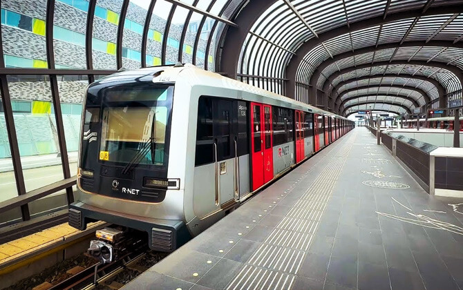
The network is also being modernized through new trains. M7 trainsets built by CAF are replacing older fleets, with further orders expected to replace remaining older stock by 2027. Like the M5 series, M7 trains are equipped for fully automatic operation using CBTC, though they still run with drivers for now.
This renewal supports higher capacity, future frequency improvements, and possible further automation.
Notable Facts
- The Amsterdam Metro opened in 1977, later than many major European metro systems.
- The original 1960s master plan envisioned four lines that would replace many trams, but strong public opposition scaled those ambitions back.
- Construction of the Oostlijn triggered the Nieuwmarkt riots in 1975.
- Weesperplein station includes an unused level for a never-built line and a never-used Cold War bomb shelter.
- Route 51 was once a hybrid metro-tram service before being separated from the tram network in 2019.
- Line 50 is the only metro line that does not pass through Amsterdam Centraal.
- Line 52, opened in 2018, was the first to run beneath the IJ and reach Amsterdam-Noord.
- As of 2026, the system has five lines and 39 stations, making it the largest metro system in the Netherlands by route length.
- Between Ganzenhoef and Kraaiennest, the East Line includes a distinctive elevated colonnade about 1,100 metres long.
- The original M1/M2/M3 trains were nicknamed zilvermeeuw because of their silvery bodies and were retired in 2015.
- By 2024, annual ridership had recovered to about 116 million passenger trips.
- Approved 2027 network changes include discontinuing Line 53 and rerouting Line 50 to Gaasperplas.
- Preparations for future expansion include a pre-built station box at Sixhaven and plans linked to Schiphol and Hoofddorp.
Sightseeing via Amsterdam Metro
The Amsterdam Metro is one of the fastest ways to get between the city center and outer districts, so it works very well for sightseeing beyond the canal belt. It connects major visitor areas such as Noord, Zuid, Bijlmer ArenA, and De Pijp, while also linking to tram and bus services for places the metro does not reach directly.
For visitors, the system is easy to use. You check in at the gates or card readers, travel, then check out at your destination. You can pay distance-based fare with OVpay or an OV-chipkaart, or choose a day pass if you expect several rides. If you’re building a practical sightseeing guide for yourself, that second option is often the easiest.
Several useful destinations sit directly on the network. Lines 50 and 54 serve Amsterdam Bijlmer ArenA, home to Johan Cruijff ArenA and major music venues. Line 53 goes to Gaasperplas, a lake and green area that makes a nice break from the center. Lines 50 and 51 also connect with areas used for trips toward Amsterdamse Bos, while Bullewijk is handy for practical stops such as IKEA.
Line 52 is especially good for sightseeing because it follows the city’s central north-south axis. It links Noord, Centraal, Rokin, Vijzelgracht, De Pijp, and Europaplein. Several of its stations are attractions in their own right, with artworks and design features that make the trip more interesting than a standard subway ride.
With operating hours from around 06:00 to 00:30 and frequent daytime service, the metro is also useful for evening plans. You can head to entertainment districts, return after dinner, or combine the metro with ferries, trams, and buses to cover a lot of ground in one day. Outside rush hour, bicycles are allowed with an extra ticket, which can be handy if you want to mix metro travel with cycling.
For anyone exploring more than just the canal ring, the metro is a smart part of transportation in Amsterdam. Pair it with trams and buses, and the city opens up quickly.