Mexico City Metro Information
Since 1969, Mexico City’s metro has come a long way. Not long ago, it was one of the top 10 busiest metros in the world. The 226.5km network, which consists of 12 lines with a total of 195 stations, is the second longest metro system in North America. Officially known as the Sistema de Transporte Colectivo, the metro is an important means of public transportation for the people of Mexico City, with an annual ridership of 1.685 billion in 2013.
The Mexico City Metro is a vital part of the city’s transportation system, carrying a substantial 4,200,000 passengers per day. However, it does not provide 24-hour service. Instead, it operates from 5:00 to 00:00 Monday to Saturday and from 7:00 to 00:00 on Sundays and holidays.
The Metro does not have air conditioning and does not allow passengers to walk between platforms. There are also no driverless trains or screen doors on the platforms.
Despite these limitations, the Metro has an average speed of 39km/h and can reach a maximum speed of 100km/h. The fare is a reasonable 5 pesos. The entire operation is efficiently managed by the Sistema de Transporte Colectivo.
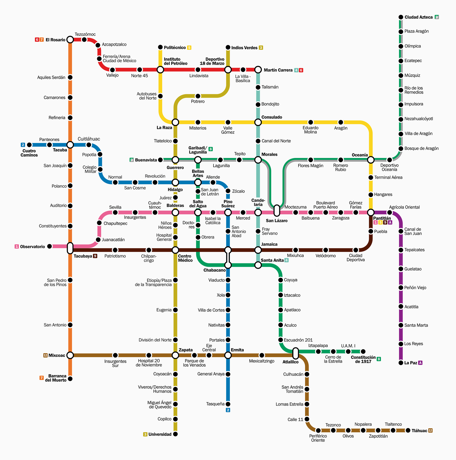
Mexico City Metro Map
Map of Mexico City Metro showing different lines and stations. Click on the map to enlarge it or download the Mexico City Metro map in PDF format.
Mexico City Metro Line and Stations
Mexico City’s metro network consists of 12 different lines, each identified by either a letter or a number and a colour. The network covers a total distance of 225 kilometres and has 195 stations. Of these, more than 60%, or 115 stations, are underground, 55 on the surface and 25 on an elevated viaduct.
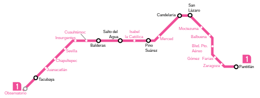
Line 1: Pantitlán – Observatorio
Line 1, known as the Pink Line, is the oldest in the system. It has a total length of 19 kilometres and serves 20 stations, including 7 transfer stations, 12 transit stations and 2 terminals. It is worth noting that 19 of these stations are underground, while only one is on the surface. The line runs from east to west in the city centre.
Stations: Observatorio, Tacubaya, Juanacatlán, Chapultepec, Sevilla, Insurgentes, Cuauhtémoc, Balderas, Salto de Agua, Isabel la Católica, Pino Suárez, Merced, Candelaria, San Lázaro, Moctezuma, Balbuena, Boulevard Puerto Aéreo, Gómez Farías, Zaragoza and Pantitlán.
For those who have seen and been impressed by the bustling crowds in Japanese subway stations, Pantitlán offers a similar scene. The proof is in a stunning video of Pantitlán at rush hour.
Line 2: Cuatro caminos – Tasqueña
Line 2, or the blue line, runs through the centre of the city from south to north. It is 23 kilometres long and has 24 stations, including 5 transfer stations, 17 transit stations and 2 terminals. There are 14 underground stations and 10 surface stations.
Stations: Cuatro Caminos, Panteones, Tacuba, Cuitlahuac, Popotla, Colegio Militar, NormalSan, Cosme, Revolución Hidalgo, Bellas Artes, Allende, Zócalo, Pino Suárez, San Antonio Abad, Chabacano, Viaducto, Xola, Villa de Cortés, Nativitas, Portales, Ermita, General Anaya, Tasqueña.

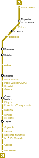
Line 3: Indios Verdes – Universidad
Line 3, known as the olive green line, is 23 kilometres long and has 21 stations. These include 6 transfer stations, 13 through stations and 2 terminals. Of these, 17 stations are underground and 4 are on the surface.
Stations: Indios Verdes, Deportivo 18 de Marzo, Potrero, La Raza, Tlatelolco, Guerrero, Hidalgo, Juárez, Balderas. Niños Héroes, Hospital General, Centro Médico, Etiopía / Plaza de la Transparencia, Eugenia, División del Norte, Zapata, Coyoacán, Viveros / Derechos Humanos, Miguel Angel de Quevedo, Copilco, Universidad.
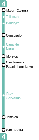
Line 4: Santa Anita – Martin Carrera
Line 4, also known as the Cyan Line, is 10 kilometres long and serves a total of 10 stations. These include 6 transfer stations and 4 through stations. Of these, 2 stations are underground and the remaining 8 are elevated flyovers.
Stations: Martín Carrera, Talismán, Bondojito, Consulado, Canal del Norte, Morelos, Candelaria, Fray, Servando, Jamaica, Santa Anita.
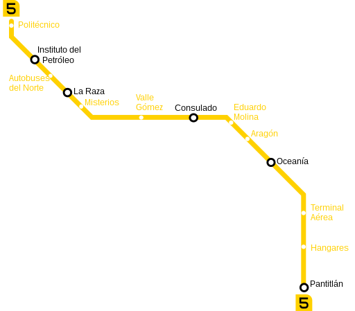
Line 5: Politecnico – Pantitlan
Line 5, represented by the colour yellow, covers a distance of 15 kilometres and serves 13 stations, including 5 transfer stations, 7 transit stations and 1 terminal. The line has 4 underground stations and 9 surface stations.
Stations: Pantitlán, Hangares, Terminal Aérea, Oceanía, Aragón, Eduardo Molina, Consulado, Valle Gómez, Misterios, La Raza, Autobuses del Norte, Instituto del Petróleo, Politécnico.
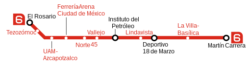
Line 6: El Rosario – Martin Carrera
Line 6, the red line of the Ciudad de Mexico metro, is 13 kilometres long and has 11 stations. These are composed of 4 transfer stations and 7 transit stations. The line has 10 underground stations and 1 surface station.
Stations: El Rosario, Tezozomoc, Azcapotzalco, Ferrería, Norte 45, Vallejo, Instituto del Petróleo, Lindavista, Deportivo 18 de Marzo, La Villa-Basílica.
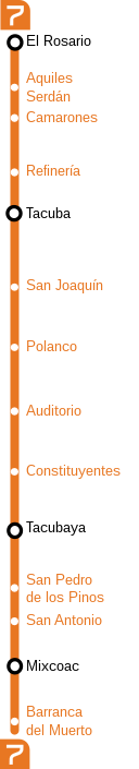
Line 7: El Rosario – Barranca del Muerto
Line 7, the orange line, is 18 kilometres long and has a total of 14 stations. These include 3 transfer stations, 10 through stations and one terminal. Of these, 13 are underground stations and one is a surface station.
Stations: El Rosario, Aquiles Sedán, Camarones, Refinería, Tacuba, San Joaquín, Polanco, Auditorio, Constituyentes, Tacubaya, San Pedro de los Pinos.
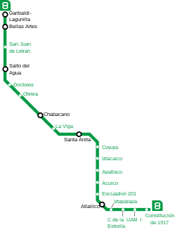
Line 8: Garibaldi – Constitucion de 1917
Line 8, also known as the Green Line, is 20 kilometres long and serves a total of 19 stations. Of these, 5 are transfer stations, 13 are through stations and only 1 is a terminus. 14 stations are underground and 5 are on the surface.
Stations: Garibaldi, Bellas Artes, San Juan de Letrán, Salto del Agua, Doctores, Obrera, Chabacano, La Viga, Santa Anita, Coyuya, Iztacalco, Apatlaco, Aculco, Escuadrón 201, Atlalilco, Iztapalapa.
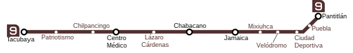
Line 9: Pantitlán – Tacubaya
Line 9, identified by its dark brown colour, is 15 kilometres long and has 12 stations. Of these, 5 are transfer stations and 7 are through stations. Of all the stations, 8 are underground and 4 are on overpasses.
Stations: Tacubaya, Patriotismo, Chilpancingo, Centro Médico, Lázaro Cárdenas, Chabacano, Jamaica, Mixiuhca, Velódromo, Ciudad Deportiva, Puebla, Pantitlán.
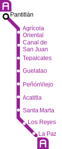
Line A: Pantitán – La Paz
Line A, shown in purple, is 17 kilometres long and serves 10 stations, including 8 transit stations and 2 terminals. Only one of these stations is underground.
Stations: Pantitlán, Agrícola Oriental, Canal de San Juan, Tepalcates, Guelatao, Peñón Viejo, Acatitla, Santa Marta, Los Reyes, La Paz.
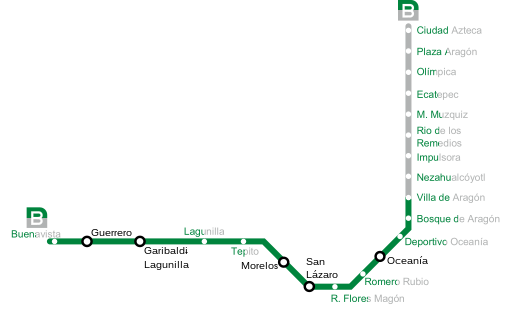
Line B: Ciudad Azteca – Buenavista
Line B, recognisable by its green and grey colour scheme, is 23 kilometres long and has 21 stations. These include 5 transfer stations, 14 through stations and 2 terminals. Of these stations, 6 are underground, 11 are at ground level and 4 are elevated.
Stations: Aragón, Olímpica, Ecatepec, Muzquiz, Río de los Remedios, Impulsora, Nezahualcóyotl, Villa de Aragón, Bosque de Aragón, Deportivo Oceanía, Oceanía, Romero Rubio, R. Flores Magón, San Lázaro, Morelos, Tepito, Lagunilla, Garibaldi, Guerrero, Buenavista.
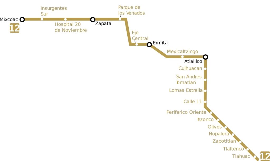
Line 12: Tláhuac – Mixcoac
Known as the Golden Line, Line 12 covers a distance of 25 kilometres and serves 20 stations.
Stations: Tláhuac, Tlaltenco, Zapotitlán, Nopalera, Olivos, Tezonco, Periférico Oriente, Calle 11, Lomas Estrella, San Andrés Tomatlán, Culhuacán, Atlalilco, Mexicaltzingo, Eje Central, Parque de los Venados, Hospital 20 de noviembre, Insurgentes Sur, Mixcoac.
Mexico City Metro Operating Hours
The Mexico City Metro operates from 5:00 to 24:00 on weekdays, 6:00 to 24:00 on Saturdays, and 7:00 to 24:00 on Sundays and holidays.
Fares and Tickets
The Mexico City metro offers affordable fares. Since 2013, the cost of a single trip has been 5 Mexican pesos. The single ticket (boleto unitario) allows you to transfer to other lines at no extra charge. This applies to the entire network except Line A, where a new ticket must be purchased.
Complimentary access is provided for:
- Senior citizens
- Persons with disabilities
- Children under 5 years old
- INJUVE youth
- Police officers
In 2006, the Metro introduced rechargeable cards, which are still in use today. The Federal District Card (TDF) was introduced in 2012 to replace them, but both types of card are still accepted. The TDF card can be used on the metro, metrobus and light rail in Mexico City. All metro lines accept TDF cards and regular tickets, except for Line 12, where only TDF cards are valid. The card costs 10 pesos and can hold a maximum balance of 120 pesos, which expires after 300 calendar days.
Bicycles are allowed on the Metro on weekends and public holidays. A student card costs 3 pesos. There is also a free card for people with disabilities.
Interesting Facts
- Due to the high risk of earthquakes in Mexico, instructions are provided on what to do in the event of an earthquake while using the metro.
- Despite being one of the cheapest metros in the world, the fare has been increased 11 times since 1969.
- The fare increase to 5 pesos was implemented after surveying users about the improvements needed in the system and how a fare increase could help.
- In 2014, more than 1.6 billion passengers used the Mexico City metro. The least used station was Tlaltenco on Line 12 with 150,000 users, while the most used was Indios Verdes with 44 million users.
Accessibility
The Mexico City metro takes into account the needs of users with reduced mobility. Most stations are equipped with facilities such as escalators, lifts, ramps, paths for the visually impaired and Braille signs.
All users who need it are allowed to bring their guide dogs on the metro.
More than 10,000 seats on the metro are reserved for people with disabilities and priority is given to them.