The Pittsburgh Light Rail system, known as “The T,” serves Pittsburgh and nearby areas of Allegheny County. It is operated by Pittsburgh Regional Transit (PRT), formerly the Port Authority of Allegheny County. The network has three color-coded lines—Red, Blue, and Silver—that link Downtown Pittsburgh with the southern suburbs.
The system covers about 42 km (26 miles) of track and includes more than 50 stations. All lines share a central trunk through Downtown and the North Shore, with part of the route running underground. South of downtown, the lines branch out toward the South Hills communities.
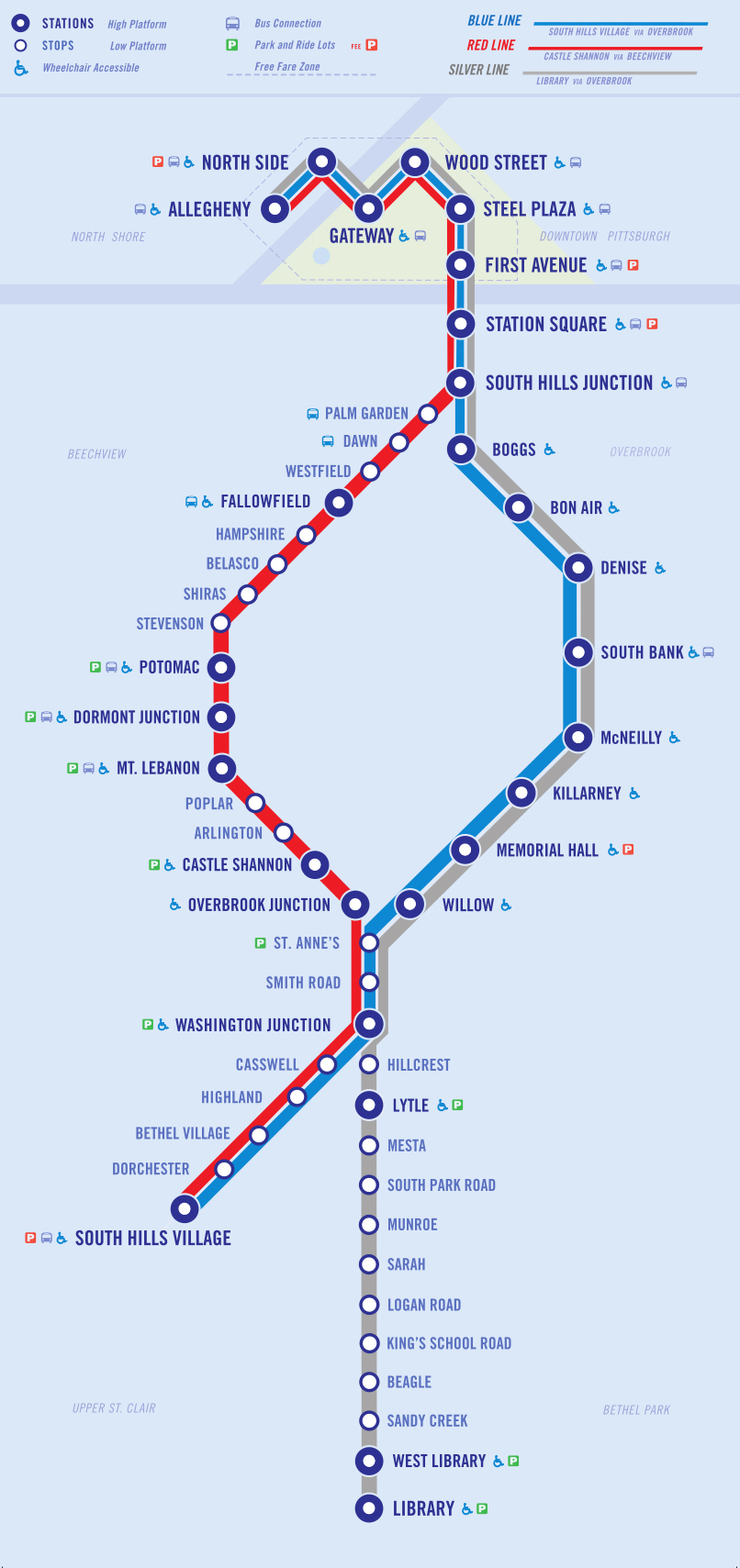
Pittsburgh Light Rail map
The 2026 Pittsburgh Light Rail map shows a straightforward network centered on north–south travel between Downtown and the southern suburbs.
The Red and Blue Lines both start at Allegheny Station on the North Shore, cross the Allegheny River via the downtown subway, and exit through the Mount Washington Tunnel. The Silver Line joins this trunk at Station Square and continues through Downtown to the North Shore.
The network has 53 stations in total, from underground subway stops downtown to at-grade stations in suburban neighborhoods. The system uses a hub-and-spoke layout, with Downtown as the hub. This simple design makes the T easy to navigate: all trains go downtown, and transfers there connect riders to any branch.
Pittsburgh Light Rail map showing different lines. Click on the map to enlarge it or download the Pittsburgh Light Rail map in PDF format.
Lines and Stations
Pittsburgh’s “T” light rail has three active lines: Red, Blue, and Silver. Each is color-coded on maps and trains. Below is an overview of each line, its route, and main stations.
Red Line
The Red Line is the oldest and longest route. It runs from South Hills Village in Upper St. Clair to Allegheny Station on the North Shore, passing through Downtown and the Beechview neighborhood. Along the way, it serves communities such as Bethel Park, Mt. Lebanon, Dormont, and Beechview.
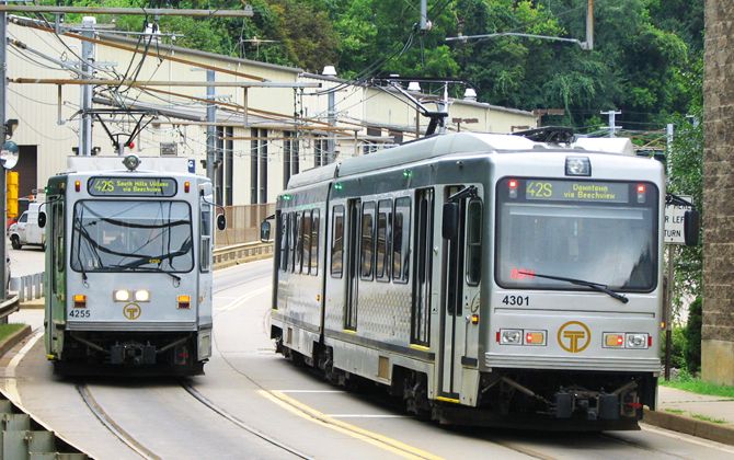
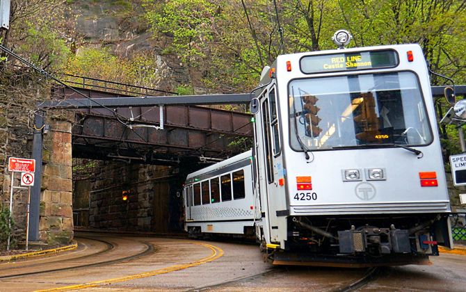
After the Mount Washington Tunnel, the Red Line branches off, climbing through Beechview on Broadway Avenue. This street-running segment has 15 closely spaced stops, reflecting its streetcar heritage. The line mixes dedicated tracks in the South Hills with on-street running in the city.
Major stations:
- South Hills Village – Southern terminus with a large park-and-ride and mall access.
- Mt. Lebanon – Serving the Mt. Lebanon business district.
- Dormont Junction – Park-and-ride in Dormont.
- Potomac – Located in Beechview.
- South Hills Junction – Transfer point to buses and the South Busway.
- Station Square – Riverfront stop with connections to the Monongahela Incline.
- First Avenue, Steel Plaza, Wood Street, Gateway – Downtown subway stations (within the Free Fare Zone).
- North Side & Allegheny – Serving PNC Park, Acrisure Stadium, and attractions on the North Shore.
The Red Line has about 32 stations, making it the system’s longest route.
Blue Line
The Blue Line also runs from South Hills Village to Allegheny Station but follows the Overbrook corridor instead of Beechview. After South Hills Junction, trains diverge onto the modernized Overbrook Line. This route provides more capacity and a quicker trip downtown.
The Overbrook segment has about eight widely spaced stops through neighborhoods such as Overbrook, Brookline, Carrick, Beltzhoover, and Bon Air. This spacing makes the Blue Line faster than the Red Line. It rejoins at South Hills Junction, then continues with the other lines through Station Square, downtown, and the North Shore.
Notable stations:
- Washington Junction – Convergence point with the Silver Line in Bethel Park.
- Castle Shannon – Large park-and-ride lot serving the South Hills.
- Neighborhood stops along the Overbrook corridor, including Overbrook Junction, Willow, and Bon Air.
Silver Line
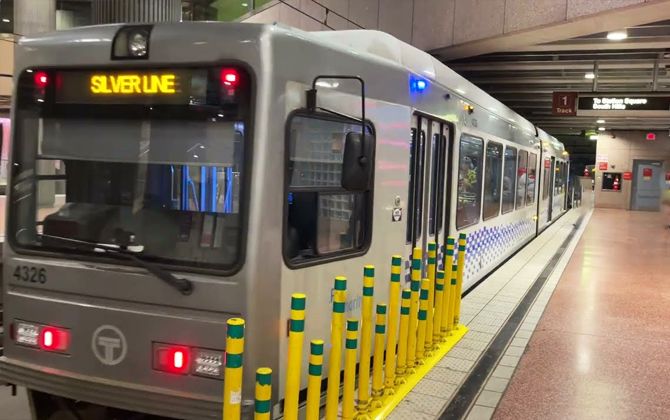
The Silver Line serves the Library branch in South Park Township. It begins at Library Station near the Allegheny–Washington County line and runs north to Washington Junction, where it merges with the Blue Line. The line was rebranded in 2020 to avoid confusion with the Blue Line.
The Silver Line has 15 stations on the Library branch, serving areas such as South Park and Bethel Park. Notable stops include Lytle, West Library, and the Library terminus, many with park-and-ride facilities. At Washington Junction, Silver Line trains either continue inbound with the Blue Line or terminate for transfers, depending on time of day.
When continuing downtown, Silver Line trains follow the Overbrook corridor, merge with the Red Line at South Hills Junction, and run through the Mount Washington Tunnel. They then serve the same downtown and North Shore stations as the other lines, ending at Allegheny Station.
Schedules
Hours of operation
Pittsburgh’s light rail runs daily from early morning to around midnight. On weekdays, the first trains leave the southern terminals around 5:00 AM (for example, a Red Line train departs South Hills Village at 4:54 AM). The last downtown departures are near midnight, with final arrivals at suburban terminals around 1:00 AM. On weekends, service starts later—about 6:00 AM on Saturdays and 8:00–10:00 AM on Sundays—and ends around midnight.
Frequency
During weekday rush hours, Red and Blue Line trains run about every 12–15 minutes. Combined, this means trains arrive downtown every 5–7 minutes. Midday and evening service drops to every 20–30 minutes. After 10:00 PM, trains usually run every 30 minutes. The Silver Line has more limited service, with some weekday off-peak and weekend trips requiring transfers at Washington Junction.
Travel times
A trip from South Hills Village to downtown takes 35–45 minutes. The Red Line is typically slower due to more stops. From Library to downtown on the Silver Line, trips take 45–60 minutes depending on transfers. Within downtown and the North Shore Free Fare Zone, stations are just minutes apart; traveling from First Avenue to Allegheny takes about 10 minutes. Service frequency peaks during commuter rush hours and slows midday and weekends.
Fares, Tickets, and Cards
Base fare: As of 2026, the standard fare is $2.75 (USD) / €2.55 (approx.) per ride. With a ConnectCard or mobile ticket, you get unlimited transfers for three hours. Paying cash also costs $2.75, but each new boarding requires another fare since transfers are not included. Using ConnectCard or mobile tickets is recommended for savings and convenience.
Discounts
- Seniors (65+) ride free with valid ID
- Children under 6 ride free with an adult (up to four per adult)
- Youth ages 6–11 pay half fare ($1.35 / €1.25 approx.) with a Kid’s ConnectCard
- Riders with disabilities and Medicare cardholders also qualify for half fare
- Some universities provide transit passes to students through school programs, but there is no general student discount.
Passes:
| Type | Price (USD) | Price (EUR, approx.) | Discounted Price (USD) | Discounted Price (EUR, approx.) | Validity |
|---|---|---|---|---|---|
| 1-day pass | $7.00 | €6.50 | – | – | Unlimited rides until end of service day |
| 7-day pass | $25.00 | €23.20 | $12.50 | €11.60 | Unlimited rides for 7 days |
| 31-day pass | $97.50 | €90.50 | $48.75 | €45.25 | Unlimited rides for 31 days |
Passes and stored value can be loaded onto a reusable ConnectCard, which costs $1. Cards can be reloaded at station vending machines, online, or retail outlets. Mobile ticketing is also available.
Travel within the Free Fare Zone—from Allegheny Station on the North Shore through Downtown to First Avenue Station—is free. This makes the T a simple and affordable option for moving around central Pittsburgh. On average, the system carries tens of thousands of riders each day and plays a key role in the city’s public transit, alongside buses and the historic incline cable cars.
Connection with Other Transportation Systems
Although small, the T is well integrated with Pittsburgh’s broader transit network.
Buses: All downtown T stations are within a short walk of many city bus stops. Pittsburgh Regional Transit operates about 98 bus routes, most of which serve Downtown. Key transfer points include:
- Steel Plaza: Direct access to Duquesne University bus stop and near the East Busway’s Penn Station.
- South Hills Junction: Connection to the South Busway; many South Hills bus routes stop here.
- Station Square: Adjacent to major bus stops on Carson Street and near the South Busway.
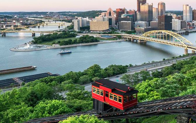
Inclines: Pittsburgh’s historic inclines connect with the T. The Monongahela Incline lower station is across from Station Square, making for an easy transfer. The Duquesne Incline is a short walk from the same station. Both accept standard transit fares, with the Monongahela Incline fully integrated into PRT’s system. Tourists often ride the T to Station Square and transfer to the incline for Mt. Washington views.
Regional transit: Several neighboring counties operate commuter buses into Downtown Pittsburgh. While they use separate fare systems, many routes stop near T stations or shared park-and-ride lots, allowing seamless transfers.
Bicycles: Many T stations have bike racks or lockers, and bicycles are allowed on trains with some limits (generally two per car, boarding at high-platform stations). This makes combining biking and rail travel straightforward.
Fare integration: The same $2.75 (USD) / €2.55 (approx.) fare and ConnectCard system apply to both buses and the T. With ConnectCard, transfers within 3 hours are free. For example, you can board a bus, tap your card, then transfer to the T without paying again. This unified system makes multimodal trips smooth and affordable.
Connection to the Airport
28X Route: The 28X Airport Flyer bus runs between Downtown Pittsburgh and Pittsburgh International Airport (about 30 km / 19 miles west of downtown). It serves Oakland, downtown stops, West Carson Street, and the West Busway near Carnegie. Outbound trips pick up at these locations, while inbound trips drop off only. Downtown stops are near major T stations like Steel Plaza, Wood Street, and Station Square, allowing quick transfers.
Frequency and hours: The 28X operates daily from about 4:00 AM to midnight, every 30 minutes in each direction. Travel time is typically 45–60 minutes depending on traffic.
Fare: The fare is the same as any regular ride: $2.75 (USD) / €2.55 (approx.), payable by ConnectCard or cash. Daily and monthly passes also cover the route. At the airport, a vending machine by Baggage Claim (Door #2) sells fares and ConnectCards for inbound travelers.
While the T does not yet extend to the airport, the 28X remains the fastest and cheapest option. Many travelers combine it with the T—for example, riding the 28X to downtown, then transferring to the T for a free ride to the North Shore. With rideshare options costing $40+ (USD) / €37+ (approx.), the $2.75 (USD) / €2.55 (approx.) bus is a reliable budget-friendly choice. Just allow at least an hour for the trip.
System rules
Pittsburgh Light Rail has rules and regulations to ensure passenger safety, reduce travel times, protect the subway system and maintain an appropriate environment. These rules are available online and at each station. Key rules include
- Only service animals are allowed on the Pittsburgh Light Rail.
- Small pets or animals are allowed if they are in a cage.
- Dogs are not allowed to run in any of the system’s facilities, including stations and trains.
- It’s not allowed to get on or off a train once the doors have begun to close.
- Passengers should not cross the yellow safety line at stations.
- Children should be held by the hand or kept close to the adult passenger.
- When travelling with prams, passengers should use specially designated areas to avoid obstructing transit.
- All transit within the system’s facilities must be on the right side of the road or concourse.
- Civilized conduct and behaviour is expected within the light rail facilities.
- Eating and drinking are strictly prohibited within the light rail facilities.
- Obstructing or leaning against train doors is prohibited.
- Designated seats are reserved for pregnant women and the elderly.
- The carrying of firearms is strictly forbidden.
- Emergency and fire alarms should only be used in case of emergency; misuse may result in penalties.
Future Expansion
Pittsburgh’s light rail has changed little since the 1980s, aside from the North Shore extension in 2012. But the 2021 NEXTransit long-range plan outlines possible projects for the next 25 years. These are concepts, not funded projects, but they show the vision for the system’s future.
Oakland and East End: Oakland is the region’s second-largest job center, home to universities and hospitals. A Bus Rapid Transit (BRT) line between Downtown, Uptown, and Oakland is already under construction. Long-term ideas include a light rail line east from downtown or even an aerial gondola from the Strip District through the Hill District to Oakland and Hazelwood.
North Side and North Hills: Another proposal is a light rail or transit line northeast along the Allegheny River corridor, possibly reaching Lawrenceville, Morningside, or New Kensington. Extending northward from Allegheny Station would likely require a new river crossing or use of existing corridors.
Airport and suburbs: A rail spur to Pittsburgh International Airport has been suggested before, but the current plan focuses on extending the West Busway to the airport. This would provide a faster bus link. Expansions of the East Busway to communities like McKeesport are also being considered.
Allentown (Brown) Line revival: The Brown Line, discontinued in 2011, could return. The tracks are still used for detours during Mt. Washington Tunnel closures. If Allentown and the South Side continue to grow, restoring this route could add redundancy and serve more riders.
Infrastructure upgrades: To support any expansion, PRT plans to add a new railcar storage and maintenance facility (estimated at ~$200 million / €186 million) and a new Downtown transit center to improve bus–rail integration. These are prerequisites for larger projects.
Parking
For suburban riders, Pittsburgh’s light rail offers more than 50 park-and-ride lots across Allegheny County. Most are along the South Hills lines and make commuting by rail easier and cheaper.
Free lots: Most park-and-ride facilities are free, including Library, Washington Junction, West Library, Lytle, and South Park Road. These are for day use only, no overnight parking allowed.
South Hills Village Garage: The system’s largest facility is a multi-level garage at South Hills Village. It charges $2 (USD) / €1.85 per day or $22 (USD) / €20 per month. A combined transit + parking “Gold Pass” costs about $119 (USD) / €110 monthly. The garage has several hundred spaces and rarely fills.
Other paid parking: Most other lots are free, but some exceptions exist. First Avenue Garage downtown charges standard city rates and is not intended for suburban commuters. North Shore lots near Allegheny and North Side stations are run by the Stadium Authority and charge event-day rates. Commuters sometimes use them on non-event days to park cheaply and ride one stop into downtown.
For commuters, parking at a suburban station and riding the T is cost-effective. A trip may cost only $2.75 (USD) / €2.55 by rail with free parking, compared to $10–$20 (USD) / €9–€18 to park downtown.
Tips
- Check the fare zones for your route and transfers to avoid unforeseen costs.
- Keep your belongings in front of you or close by to prevent theft.
- Avoid using the light rail during peak hours if you are convalescing or travelling with newborns due to potential crowding.
- Check peak time information and train arrival times to avoid delays.
- Make room for other passengers on the train to ensure a smooth journey.
- Locate safety handles or rails and route maps once on the train to ensure a safe and precise journey.
Brief History
Pittsburgh’s light rail grew out of one of the largest streetcar systems in the U.S. In the early 20th century, the city was covered by electric streetcars run by Pittsburgh Railways Company. By the 1960s, it was the nation’s largest surviving streetcar system, with more than 600 PCC cars on 41 routes. In 1964, the Port Authority (now PRT) took control and began converting lines to bus service. By the 1970s, only South Hills routes using the Mount Washington Tunnel still operated as rail.
Public pressure led to a decision to modernize instead of abandoning streetcars. From 1980 to 1985, the “Stage I” Light Rail Modernization rebuilt tracks, upgraded power, ordered new Siemens cars, and constructed a downtown subway using a repurposed 1860s rail tunnel. The first segment opened in 1984, with the full system finished by 1987. The $522 million project created two main routes: South Hills Village (today’s Red Line) and Library (via Overbrook, later closed in 1993).
Key milestones:
- 1984–1987: Opening of the modern light rail and downtown subway, replacing most streetcars.
- 1993: Overbrook Line closed for safety, truncating Library service. Remaining PCC cars were retired by 1999.
- 2004: Overbrook Line rebuilt and reopened with new infrastructure and vehicles.
- 2012: North Shore Connector opened, adding North Side and Allegheny stations via new tunnels under the Allegheny River. Cost: $523 million / €485 million.
- 2020: Library service renamed Silver Line to reduce confusion with the Blue Line.
- 2022: Port Authority rebranded as Pittsburgh Regional Transit with updated logos and livery.
Pittsburgh pioneered PCC streetcars, with the world’s first PCC entering service here in 1936. Unlike most U.S. cities, Pittsburgh never lost rail service completely; its network evolved from streetcars into modern light rail. The system continues to blend historic elements, like the 1904 South Hills Tunnel and Beechview street-running, with modern upgrades.
Other quirks include the discontinued Brown Line (closed 2011), the short-lived Penn Station spur, and unique reuse of infrastructure like the 19th-century Grant Street tunnel and the 1903 Panhandle Bridge. Overall, community advocacy in the 1970s preserved rail service and shaped The T that exists today.
Fun Facts
- Free subway rides: The T offers a Free Fare Zone downtown and on the North Shore, making it one of the few U.S. rail systems with free core service.
- First PCC in the world: In 1936, Pittsburgh introduced PCC #100, the first passenger PCC streetcar in service worldwide.
- Street-running trains: Along Broadway Avenue in Beechview, Red Line trains run in mixed traffic, a rare feature in U.S. light rail.
- Old tunnels reused: The downtown subway uses an 1860s rail tunnel, and the Panhandle Bridge (1903) was converted for light rail.
- Steep grades: The Allentown Brown Line (now closed) featured a 10% incline—extremely steep for rail service.
- Wabash Tunnel: Once planned for light rail to the airport, it was converted instead for buses and HOV traffic.
- “Ghost” Penn Station: An unfinished downtown station exists near Amtrak’s Penn Station. Built in the 1980s, it was never opened but has been used as a turnaround during projects.
- Sports fans: On Steelers game days, thousands ride the T to the North Shore. The North Shore Connector was partly built to serve stadium crowds.
- Film appearances: The T has been featured in movies, including “The Dark Knight Rises” (2012), where Pittsburgh stood in as Gotham City.
- Ridership trends: The system carried about 28,000 weekday riders in the 1980s, about 27,000 in 2019, dropped to ~3,000 during COVID-19, and has been recovering since.
These details highlight the T’s unique blend of history, quirks, and community role. Though modest in size, Pittsburgh’s light rail is rich in character—just like the city it serves.
What to See from the Pittsburgh Light Rail
Riding the T is not only practical but also a way to see Pittsburgh. Here are some highlights along the routes:
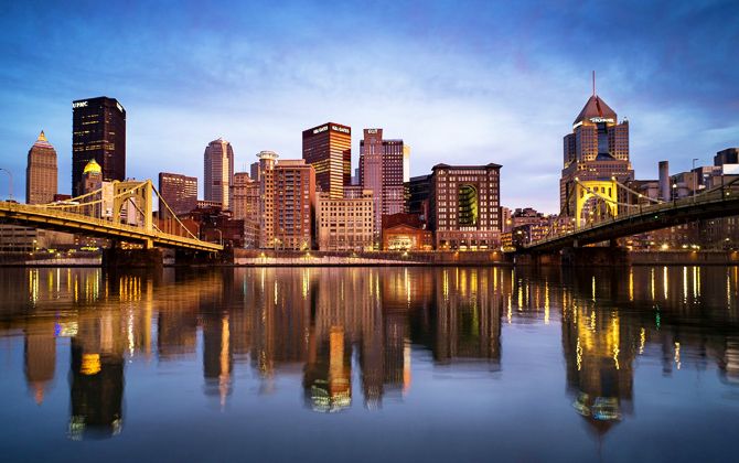
Downtown skyline and rivers: Between Station Square and First Avenue, the train crosses the Monongahela River on the Panhandle Bridge. Look left when heading inbound for sweeping views of the skyline, Point State Park, and river traffic. At night, the city lights make the view especially memorable.
Station Square and Mount Washington: Right outside Station Square Station you’ll find restaurants, shops, and the historic station building. Across the street is the Monongahela Incline, which takes you to the top of Mount Washington for a classic city panorama.
North Shore: Allegheny Station puts you beside Acrisure Stadium and near the Carnegie Science Center and Rivers Casino. One stop away, North Side Station serves PNC Park and the Andy Warhol Museum. The riverfront parks here also offer great downtown views.
Beechview: The Red Line runs in the street along Broadway Avenue, passing houses, shops, and local favorites like Las Palmas taco stand. This streetcar-style segment is unique in the U.S. and worth experiencing up close.
Mt. Lebanon Uptown: Mt. Lebanon Station opens into a walkable district with cafes, boutiques, and restaurants. Washington Road has a lively suburban downtown feel, especially festive in winter with holiday lights.
South Hills Village: At the southern end of the Red and Blue Lines, South Hills Village Station connects directly to a large mall. It’s a popular stop for both commuters and shoppers.
Library and South Park: The Silver Line’s Library Station sits near South Park, one of Allegheny County’s largest parks. A short walk or bike ride leads to trails, picnic areas, and summer attractions like the wave pool.