Honolulu Skyline is a fully automated light metro system on the island of Oʻahu, Hawaiʻi. It serves the City and County of Honolulu and is the first metro rail system in the state. The project was designed to offer a fast and reliable alternative to the island’s congested highways.
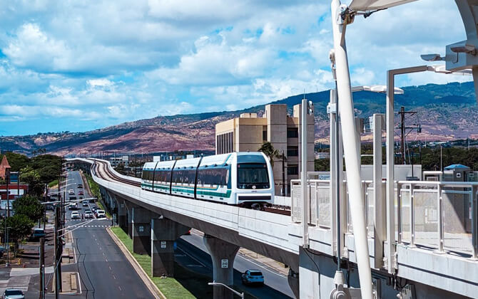
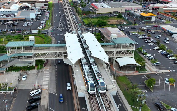
The line runs mostly on elevated tracks along an 18.9-mile (30.4 km) corridor. It features modern stations and driverless trains. Skyline is owned by the city’s Department of Transportation Services and operated by Hitachi Rail under contract.
Passenger service began in 2023. The current route connects East Kapolei in the west with the Kalihi Transit Center near Honolulu (Middle Street) in the east. Future extensions will bring the line into downtown Honolulu as construction progresses.
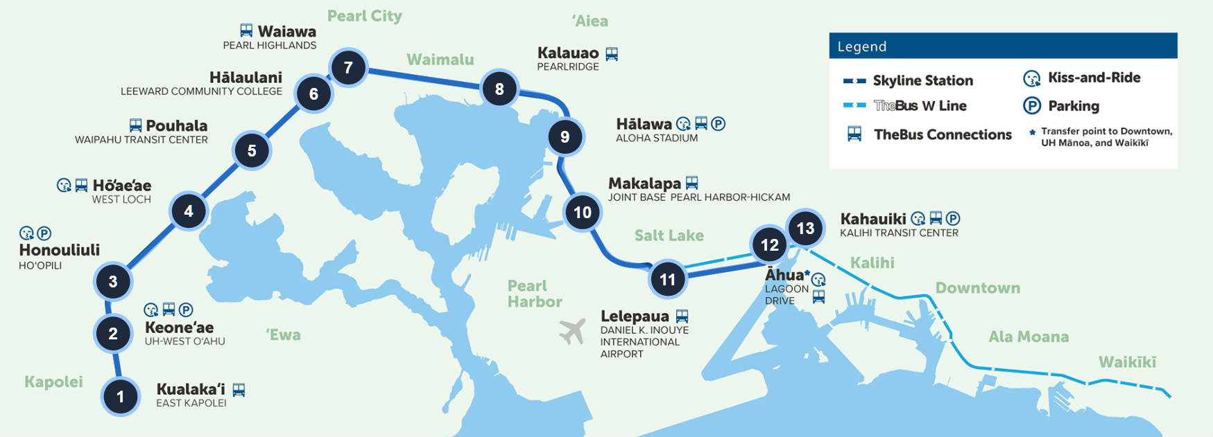
Honolulu Skyline Map 2026
Honolulu Skyline map showing 1 lines and 13 stations. Click on the map to enlarge it or download the Honolulu Skyline map in PDF format.
Honolulu Skyline Line and Stations
Skyline currently operates a single line with 13 stations (as of 2026). The route runs from Kualakaʻi (East Kapolei) in the west to Kahauiki (Kalihi Transit Center) in the east. Trains operate end-to-end and stop at every station.
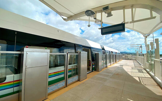
The line is fully grade-separated and mostly elevated. Stations are equipped with platform screen gates for added safety.
- Station 1: Kualakaʻi – East Kapolei. Western terminus serving the Kapolei area. Located about 2 miles (3.2 km) from Ka Makana Aliʻi mall.
- Station 2: Keoneʻae – University of Hawaiʻi West Oʻahu. Adjacent to the UH West Oʻahu campus and nearby residential communities.
- Station 3: Honouliuli – Hoʻopili. Serving the growing Hoʻopili residential development.
- Station 4: Hō‘ae‘ae – West Loch. Serving West Loch and parts of Waipahu.
- Station 5: Pouhala – Waipahu Transit Center. Located in historic Waipahu town, near Hawaiʻi’s Plantation Village outdoor museum.
- Station 6: Hālaulani – Leeward Community College. Adjacent to Leeward Community College and the Pearl City area.
- Station 7: Waiawa – Pearl Highlands. Near Pearl Highlands Center. Includes a park-and-ride facility and serves as a major bus connection point.
- Station 8: Kalauao – Pearlridge. Serving the ʻAiea area and located about 0.5 miles (0.8 km) from Pearlridge Center mall.
- Station 9: Hālawa – Aloha Stadium. Serving Aloha Stadium, home of the popular Swap Meet bazaar, and surrounding neighborhoods.
- Station 10: Makalapa – Joint Base Pearl Harbor–Hickam. Serving Pearl Harbor Naval Base and Hickam Air Force Base. This is the closest Skyline station to the Pearl Harbor National Memorial and USS Arizona Visitor Center, accessible by bus or a short taxi ride.
- Station 11: Lelepaua – Daniel K. Inouye International Airport. Serving Honolulu International Airport (Terminal 2). Connected to the terminal parking garages via a pedestrian bridge.
- Station 12: Āhua – Lagoon Drive. Serving the airport industrial area and the Lagoon Drive corridor.
- Station 13: Kahauiki – Kalihi Transit Center (Middle Street). Current eastern terminus. Includes a bus hub with connections to Downtown Honolulu and other urban destinations.
Six additional stations are under construction. These will extend the line further east into Honolulu’s city center.
Honolulu Skyline Timetable & Operating Hours
Hours of operation
Skyline runs daily from 4:00 a.m. to 10:30 p.m., including weekends and holidays. Service starts early for commuters and airport travelers and continues until late evening.
The first trains depart both end stations — East Kapolei and Kalihi Transit Center — at 4:00 a.m. The last full-length trips leave around 10:00 p.m., arriving at the final stations at approximately 10:34 p.m.
Frequency
From the start of service until about 8:30 p.m., trains arrive every 10 minutes at each station. Between roughly 8:30 p.m. and 10:30 p.m., trains run every 15 minutes. The schedule is the same every day of the week.
A full end-to-end ride takes about 34 minutes one way. A round trip takes just over one hour. During peak commute hours, trains continue to operate at consistent 10-minute intervals to provide steady service.
Weekends & Holidays
Skyline operates from 4:00 a.m. to 10:30 p.m. on weekends and city holidays. There is no reduced weekend schedule. Trains run every 10 minutes most of the day and every 15 minutes later in the evening.
On special occasions, service hours may be extended. For example, on New Year’s Eve trains operated until 1:30 a.m. to support late-night celebrations and safe travel. Any schedule changes are announced in advance.
Outside of special events, the standard daily timetable applies year-round, making Skyline a dependable option any day of the week.
Honolulu Skyline Tickets, Prices and Discounts
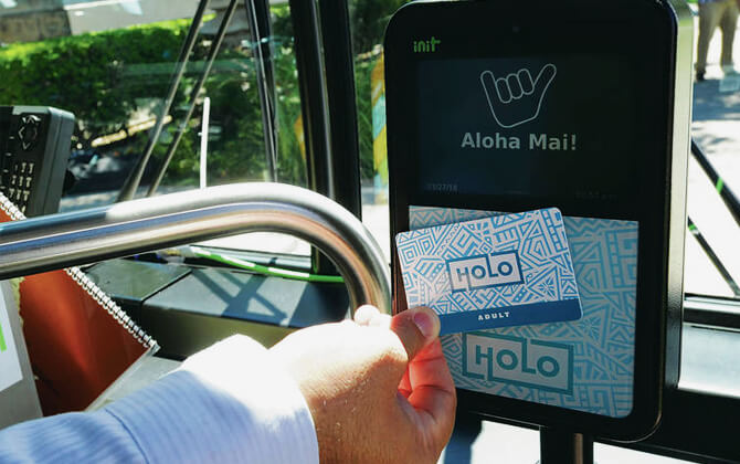
Skyline uses the same fare system as TheBus. One payment method covers both trains and city buses. All fares are paid with the HOLO card, a contactless smart card used at station gates and on buses. Cash is not accepted at Skyline stations.
A HOLO card costs $2.00 USD (one-time purchase). You can load money or passes onto the card. Transfers between Skyline and TheBus are free for 2.5 hours after your first tap. The system also includes fare capping: once you reach the daily or monthly limit, additional rides during that period are free.
Adult fares (ages 18–64): A single ride costs $3.00 USD and includes unlimited transfers within 2.5 hours. The daily cap is $7.50 USD. After reaching that amount in one day, no further charges apply. The monthly cap is $80.00 USD. Prepaid visitor options include a 3-day pass for $20.00 USD and a 7-day pass for $35.00 USD. A regular monthly pass also costs $80.00 USD.
| Fare Type | Adult Price (USD) | Use & Validity |
|---|---|---|
| Single ride (HOLO) | $3.00 | 2.5 hours of unlimited transfers |
| Daily Cap | $7.50 | Maximum charged per day |
| 3-Day Pass | $20.00 | 72 hours from first use |
| 7-Day Pass | $35.00 | 168 hours (7 days) from first use |
| Monthly Cap/Pass | $80.00 | Maximum per calendar month |
| HOLO Card Fee | $2.00 | One-time card purchase |
Note: Children 5 and under ride free with a paying adult (one child per adult, provided the child does not occupy a separate seat).
Discounted fares are available for youth, seniors, riders with disabilities, Medicare card holders, and ADA paratransit users. A specialized HOLO card is required to receive reduced rates.
Youth Fares
Youth fares apply to ages 6–17 and high school students up to 19 with valid ID. A Youth HOLO card is required.
Single ride: $1.50 USD (2.5-hour transfers included).
Daily cap: $3.75 USD.
Monthly cap/pass: $40.00 USD.
HOLO card fee: $2.00 USD.
Youth cards expire after the school year of the holder’s 18th birthday unless proof of continued enrollment is provided.
Senior Fares
Seniors aged 65+ qualify for reduced fares with a Senior HOLO card.
Single ride: $1.25 USD (2.5-hour transfers included).
Daily cap: $3.00 USD.
Monthly pass (Hawaiʻi residents): $20.00 USD.
Annual pass (Hawaiʻi residents): $45.00 USD per year.
HOLO card fee: $2.00 USD.
Non-resident seniors can still use the $1.25 fare and $3.00 daily cap, but discounted monthly and annual passes are limited to local residents.
Disability Card
Riders with qualifying disabilities may apply for a Disability HOLO card. The fare structure is the same as for seniors.
Single ride: $1.25 USD.
Daily cap: $3.00 USD.
Monthly pass (residents): $20.00 USD.
Annual pass (residents): $45.00 USD.
HOLO card fee: $2.00 USD.
An application and medical certification are required. Temporary disability cards are also available.
U.S. Medicare Card
Riders under 65 with a valid U.S. Medicare card can receive the same discounted rates as seniors.
Single ride: $1.25 USD.
Daily cap: $3.00 USD.
Monthly pass (Hawaiʻi residents): $20.00 USD.
Annual pass (Hawaiʻi residents): $45.00 USD.
Card fee: $2.00 USD (valid for 4 years).
Applications are processed at TheBus Pass Office with Medicare card and ID.
TheHandi-Van
TheHandi-Van is Honolulu’s ADA paratransit service. It provides door-to-door transport for riders unable to use regular bus or rail service.
Handi-Van trip: $2.25 USD per one-way trip ($2.00 USD for eligible low-income riders).
Handi-Van eligible riders receive a special HOLO card for discounted Skyline and bus travel:
Fixed-route single ride: $1.25 USD.
Daily cap: $2.00 USD.
Monthly cap: $6.00 USD.
Annual pass: $35.00 USD.
This allows unlimited regular bus and Skyline use for a maximum of $6.00 per month.
All fares are in U.S. dollars (USD). Hawaiʻi’s local currency is USD. Prices are current as of 2026 and may change.
U-Pass
The U-PASS is a semester transit pass for students at participating colleges on Oʻahu. It provides unlimited rides on Skyline and TheBus.
Participating institutions include the University of Hawaiʻi at Mānoa, UH West Oʻahu, Honolulu Community College, Leeward Community College, Windward Community College, Chaminade University, and Hawaiʻi Pacific University.
Pricing varies by campus. For example, at the University of Hawaiʻi at Mānoa, a semester U-Pass costs $225.00 USD. It provides unlimited transit access during the academic term.
Some schools include the pass in student fees. Others offer it as an optional purchase. The pass is linked to a student HOLO card and is valid on all Skyline and TheBus routes.
Park-and-Ride
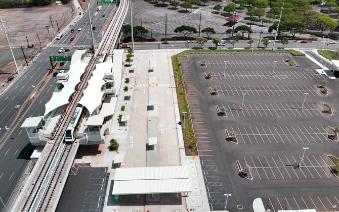
Several Skyline stations offer free Park-and-Ride facilities. Parking is available for transit users at no charge, provided you use Skyline or TheBus. Vehicles may not remain parked for more than 24 hours.
There are currently four official Park-and-Ride locations:
- Keoneʻae (UH West Oʻahu) Station – Park & Ride #1. Entrance from Hoʻomohala Avenue off Kualakaʻi Parkway. Serves Kapolei and ʻEwa residents.
- Honouliuli (Hoʻopili) Station – Park & Ride #2. Entrance via Kamālie Mua Street off Hoʻomohala Avenue. Convenient for Hoʻopili neighborhoods.
- Hālawa (Aloha Stadium) Station – Park & Ride #3. Entrance from Salt Lake Boulevard, using part of the Aloha Stadium parking area. The stadium is closed for redevelopment, but parking remains open for Skyline riders. The Swap Meet operates on select days, so expect higher traffic then.
- Kahauiki (Kalihi Transit Center, Middle Street) Station – Park & Ride #4. Entrance from Middle Street, next to the transit center bus facility. This lot has about 95 parking spaces for rail users.
In total, there are more than 1,200 free parking spaces across all Skyline Park-and-Ride facilities.
Lots typically open around 3:30–4:00 a.m., matching the first train departure. Some remain accessible past midnight, especially at Aloha Stadium.
About six stations also provide “Kiss-and-Ride” areas for quick drop-off and pickup. Parking in these zones is limited to 10 minutes.
No permit is required. Parking is first-come, first-served. Park only in designated transit areas. Security patrols monitor the stations, but valuables should not be left in vehicles. These lots are not intended for airport or multi-day parking.
Connection to the Airport
Skyline directly connects to Honolulu’s main airport (HNL). The Lelepaua Station at Daniel K. Inouye International Airport opened in October 2025.
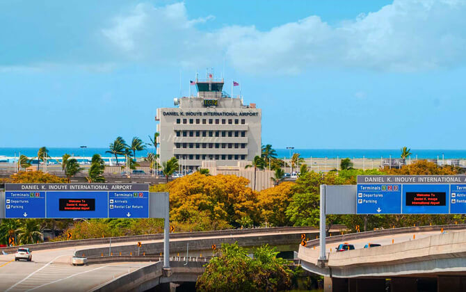
The station is located on the mauka (mountain) side of Terminal 2. Pedestrian bridges connect it to the Terminal 2 parking garage and the International Parking Garage on the 4th floor. Clearly marked walkways guide passengers to check-in counters and baggage claim. There is also a ground-level entrance on Ala Onaona Street.
Skyline offers a low-cost alternative to taxis and rideshares. A train ride costs $3.00 USD, compared to $30–$40 USD for a taxi to Waikīkī. If you arrive between 4:00 a.m. and 10:30 p.m., you can take the train directly from the airport.
Luggage is allowed. Each passenger may bring one large suitcase and one carry-on bag. Elevators are available. Travel time from the airport to Middle Street is about 10 minutes. A full ride to Kapolei takes about 33 minutes.
Skyline currently ends at Kalihi (Middle Street), a few miles from Downtown and Waikīkī. To connect, the city operates the “W Line” Airport Bus. This route runs every 10 minutes between the airport station, Downtown Honolulu, Ala Moana Center, and Waikīkī.
The W Line accepts HOLO cards. Transfers are free within 2.5 hours of your first tap. After 10:30 p.m., overnight bus routes (such as Route 40 or 42) serve the airport area.
Traveling to the airport is also simple. Riders from west Oʻahu can take Skyline directly. Those coming from Waikīkī or Downtown can take a bus to the airport station and transfer.
Stations and trains are monitored. Even with luggage, Skyline is generally safe. If your flight arrives after 10:30 p.m., you will need to use a taxi, rideshare, or late-night bus service.
Safety and Regulations
Skyline was designed with safety and comfort in mind. Stations and trains include modern security systems, and clear rules help maintain a clean and orderly environment.
Automated trains and platform safety: Trains operate without drivers but are constantly monitored from a central control center. All stations have platform screen gates that open only when trains stop. Always wait for doors to fully open before boarding. Never attempt to retrieve items from the track area. Notify staff instead.
Security presence: CCTV cameras operate throughout stations and trains. Security officers patrol regularly. Emergency call boxes are available on platforms, and intercoms are installed inside trains. If needed, you can move between train cars or exit at the next station. Staff are present at many stations during operating hours.
No eating or open drinks: Food and beverages may not be consumed on trains or inside stations. Drinks must be in sealed containers. Open cups or food items are not allowed. Violations may result in fines.
No smoking: Smoking and vaping are prohibited on trains, in stations, and within 20 feet (6 meters) of station entrances. This includes outdoor areas.
Baggage and large items: Passengers may bring one large suitcase and one carry-on item at no extra charge. Items must not block doors or aisles. Elevators and wider fare gates are available for bulky items. Designated areas inside trains accommodate bicycles and luggage. Travel during off-peak hours if carrying large items.
Animals: Service animals are allowed without restriction. Other pets must remain in carriers that fit on your lap or under a seat. Animals may not occupy seats.
Audio and conduct: Use headphones for music or videos. Keep phone calls brief and quiet. No soliciting or playing instruments is permitted. Maintain respectful behavior.
Cleanliness: Do not litter. Trash bins are located at station entrances. Vandalism, spitting, or damaging property is illegal. Report spills or hazards to staff.
Personal safety tips: Hold handrails when standing. Remain behind platform safety lines until trains stop completely. Never enter the track area — it contains a high-voltage third rail. Use escalators and elevators carefully.
Station facilities: Restrooms are available at all stations but may remain locked. Ask staff for access if needed. Some stations provide water fountains or bottle-filling stations. Open containers may not be brought onto trains.
Legal enforcement: Fare evasion is illegal and may result in fines. Harassment or assault of transit staff carries severe penalties. Weapons, explosives, and hazardous materials are strictly prohibited. If you notice suspicious activity, report it immediately.
Skyline is modern, well-lit, and monitored. By following the rules, riders help keep the system safe and comfortable for everyone.
Fun Facts
- First of its kind in the U.S.: Skyline is the first fully automated (driverless) metro system in the United States. It is also the first large-scale U.S. transit system with platform screen doors at every station. Train operations are managed from a central control center.
- Modern trains: The fleet includes 20 four-car trainsets built by Hitachi Rail. Each train is about 260 feet (79 meters) long and can carry up to 800 passengers at maximum capacity. Trains are fully air-conditioned and offer free Wi-Fi. There are designated spaces for wheelchairs, bicycles, surfboards, and luggage. The system runs on electric power via a third rail and produces zero emissions at the point of use.
- Largest public works project in Hawaiʻi: Construction began in 2011. The full 20-mile (32 km) project is expected to cost over $10 billion USD, significantly more than initial estimates. Despite the cost, it is projected to reduce congestion and support long-term growth.
- Name and logo: The system was officially named “Skyline” in 2023. For years, locals simply called it “the rail.” The name references the manu-o-Kū (white tern), Honolulu’s official bird. The logo features a bird in flight and reflects both the elevated design and Hawaiian culture.
- Environmental impact: Once fully extended to Ala Moana, Skyline is projected to remove about 40,000 car trips per day from Oʻahu’s roads. As Hawaiʻi increases renewable energy production, the system’s carbon footprint will continue to decrease.
- Opening enthusiasm: During the first five days of free rides in 2023, more than 71,000 passengers tested the system. The launch was widely celebrated across the island.
- Scenic views: The elevated track, often 30–60 feet (9–18 meters) above ground, offers panoramic views of Honolulu, Pearl Harbor, the Waianae Mountains, and the coastline. A full round trip takes about one hour.
- Speed and resilience: Trains reach speeds of up to 55 mph (89 km/h). The guideway is elevated above flood zones and built to withstand tropical storms and seismic activity.
- Hawaiian station names: Each station includes a Hawaiian name tied to local history and geography. Stations also feature artwork by local artists and sustainable design elements such as solar panels at select locations.
- Comparable systems: At 18.9 miles (30.4 km) currently in operation, Skyline is similar in length to the Miami MetroRail. Honolulu is one of the smallest U.S. cities to build a full metro system.
- Pop culture cameo: An elevated Honolulu train appeared in the 2014 film Godzilla. At the time, the real guideway was under construction.
History
Honolulu’s rail plans date back to the 1960s, when traffic congestion began worsening. Several attempts were made before the current project finally moved forward.
Early proposals: In 1966, Mayor Neal Blaisdell proposed rail as a congestion solution. In the 1970s, Mayor Frank Fasi advanced a federal funding plan, but the project was canceled in 1981 due to budget cuts and political changes. Attempts in the late 1980s and early 1990s also failed. In the 2000s, bus rapid transit was considered but never implemented.
Modern launch: The current project began as the Honolulu High-Capacity Transit Corridor Project. In 2005, the state authorized a General Excise Tax surcharge to fund rail. In 2008, Oʻahu voters approved the project with about 53% support. Groundbreaking took place on February 22, 2011.
Construction challenges: The Honolulu Authority for Rapid Transportation (HART) was created in 2011 to oversee construction. Initial estimates projected a 20-mile (32 km), 21-station system costing $5–6 billion USD and opening by 2020. Delays followed due to archaeological discoveries, utility relocation, contractor issues, and funding gaps. Costs eventually exceeded $10 billion USD.
Opening of Segment 1: On June 30, 2023, the first 10.75-mile (17.3 km) segment opened, connecting East Kapolei to Aloha Stadium with 9 stations. The launch included free rides and large public attendance.
Airport extension: On October 16, 2025, a second 5-mile (8 km) segment opened, extending service to the airport and Middle Street. Four new stations were added, significantly increasing the system’s usefulness.
Current construction: As of 2026, work continues on the City Center segment. Six additional stations are planned through Downtown Honolulu toward Kakaʻako. The target opening is 2031. The final two stations to Ala Moana Center remain unfunded but are planned.
Political context: Rail was a major issue in several mayoral elections. Critics cited high costs and delays. Supporters emphasized long-term traffic relief. Now that trains are operating, public perception has gradually improved.
After decades of debate and planning, Skyline finally became reality in 2023. The system continues to expand and is expected to shape Oʻahu’s transportation future for generations.
Future Developments & Expansion
The Skyline system is still expanding. The current eastern terminus at Kalihi (Middle Street) is temporary. Additional segments are under construction, with long-term plans for further growth.
City Center to Civic Center (Segment 3): This 4.3-mile (6.9 km) extension is now under construction. It will add six new stations: Kalihi (Mokauea Street), Kapālama (near Honolulu Community College), Iwilei (Dillingham Blvd/N. King Street area), Chinatown (College Walk area), Downtown (Bishop Street area), and Civic Center (South Street/Halekauwila Street in Kakaʻako).
Construction began in late 2023. The target opening date is March 2031. Once completed, Skyline will finally reach Downtown Honolulu, which is expected to significantly increase ridership. Civic Center (Kaʻākaukukui) will likely serve as the eastern terminus at that time.
Ala Moana extension (deferred): The original plan included two additional stations beyond Civic Center: Kūkuluaeʻo (Kakaʻako) and Kālia (Ala Moana Center). This final 0.8-mile (1.3 km) segment was postponed due to funding shortages.
Ala Moana Center is considered a critical destination and transit hub. If completed, the full line would extend about 20 miles (32 km) with 21 stations. Projected ridership could exceed 100,000 daily trips, with some estimates around 119,600 riders per day. As of 2026, funding for this final section has not been secured.
Future visions: Waikīkī and UH Mānoa: Long-term planning documents have proposed future extensions from Ala Moana toward Waikīkī and the University of Hawaiʻi at Mānoa. One possible branch would follow Kūhiō Avenue into Waikīkī. Another could head inland to the UH Mānoa campus.
These areas generate significant traffic. However, these extensions remain conceptual. They are not funded or scheduled.
Westward extension: On the western side, there have been discussions about extending the line beyond East Kapolei. Potential areas include Kapolei town center, Kalaeloa, and Ko Olina. No formal plans are in place, but the system was designed to allow future expansion.
Service improvements: Once the full route is open, the city may introduce more frequent service or limited-stop operations to reduce travel times between Kapolei and urban Honolulu. The fleet includes 20 trainsets, allowing room for increased service as demand grows.
Transit-oriented development (TOD) is also planned around several stations. Zoning changes encourage new housing and commercial projects near rail stops to boost ridership.
Funding outlook: The Civic Center segment is funded through local tax revenue and federal support. Further expansion will require additional funding sources. Options include extending the local tax surcharge, securing new federal grants, or forming public-private partnerships.
If all planned segments are completed, Skyline would run roughly 20 miles (32 km) across southern Oʻahu. Additional extensions to Waikīkī or UH Mānoa would further transform mobility on the island. For now, the confirmed milestone is the Downtown extension targeted for 2031.
Nearby Attractions
Travelers often ask what places they can reach using Skyline. While the first segment mainly serves suburban areas, several attractions are already accessible. As the line expands, many more destinations will be directly connected.
- Pearl Harbor Historic Sites: Makalapa Station (Pearl Harbor) is the closest stop to the Pearl Harbor National Memorial (USS Arizona Visitor Center). From the station, it’s about a 15–20 minute walk (1–1.5 km / 0.6–0.9 miles) or a 5-minute bus or rideshare trip. Visitors can explore the USS Arizona Memorial, Battleship Missouri, USS Bowfin submarine museum, and the Pacific Aviation Museum. Arrive early for Arizona Memorial tickets. The first trains arrive well before the sites open at 7:00 a.m.
- Aloha Stadium & Swap Meet: Hālawa Station sits next to Aloha Stadium. While the stadium is closed for redevelopment, the Aloha Stadium Swap Meet operates on Wednesdays, Saturdays, and Sundays. It’s one of the best places for local souvenirs and food. Skyline drops you directly at the entrance.
- Pearlridge Center: Kalauao Station (Pearlridge) is about 0.5 miles (0.8 km) from Pearlridge Center, Hawaiʻi’s second-largest mall. The mall includes department stores, restaurants, and entertainment. Nearby are Pearl Harbor Center shops and Sumida Watercress Farm. Pali Momi Medical Center is also close to the station.
- Waipahu & Plantation Village: Pouhala Station (Waipahu Transit Center) is about a 5–10 minute walk (0.3–0.5 miles / 0.5–0.8 km) from Hawaiʻi’s Plantation Village. This outdoor museum showcases plantation-era history. The surrounding area offers local markets and well-known Filipino eateries.
- Kapolei & Ka Makana Aliʻi: Kualakaʻi Station (East Kapolei) is roughly 2 miles (3.2 km) from Ka Makana Aliʻi shopping center. You’ll need a bus or rideshare to reach it. Nearby attractions include Wet‘n’Wild Hawaiʻi water park and Ko Olina resorts further west.
- Leeward Coast access: From Honouliuli and Keoneʻae stations, bus routes connect to Ko Olina, Kapolei City Center, and the Waianae Coast. Combining train and bus allows access to beaches like White Plains and Māʻili without renting a car.
- Future downtown attractions: Once the extension opens (target 2031), Skyline will reach Chinatown, Downtown Honolulu, and the Civic Center area. This will provide easy access to ʻIolani Palace, the King Kamehameha Statue, Hawaiʻi State Art Museum, Aloha Tower Marketplace, Honolulu Museum of Art, and the Neal S. Blaisdell Center. If the Ala Moana station is completed, riders will also reach Ala Moana Beach Park, Magic Island, and Ala Moana Center directly.
- The scenic ride itself: The elevated track, often 30–60 feet (9–18 meters) above ground, offers views of the Waianae Mountains and Pearl Harbor. A full round trip takes about one hour. Sunset rides are especially scenic.
Even in its current form, Skyline provides access to historic landmarks, shopping centers, and local neighborhoods. As the system expands toward Downtown and Ala Moana, it will become an even more practical way to explore Oʻahu without a car.