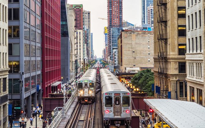
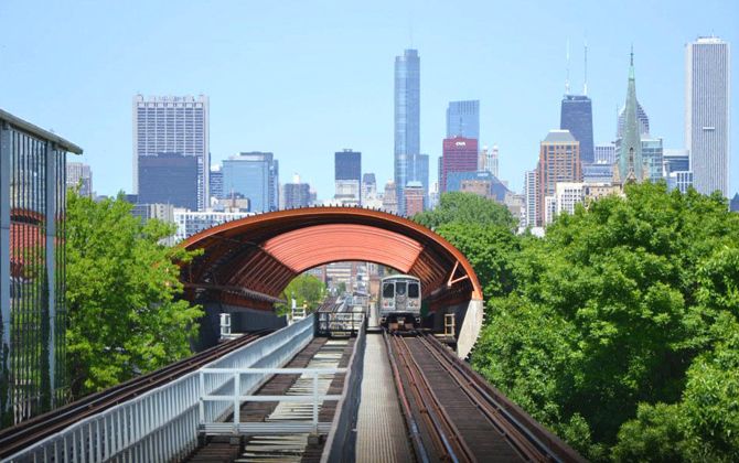
The Chicago “L” (short for “elevated”) is the city’s rapid transit system, operated by the Chicago Transit Authority (CTA). It has 8 lines, 146 stations, and 224.1 miles (360.6 km) of track. In 2024, the system carried about 127.5 million rides, with an average of 389,000 rides per weekday.
The “L” began operating in 1892 with steam trains, making it the second-oldest urban transit system in the United States. Today, CTA is the nation’s second-largest transit agency.
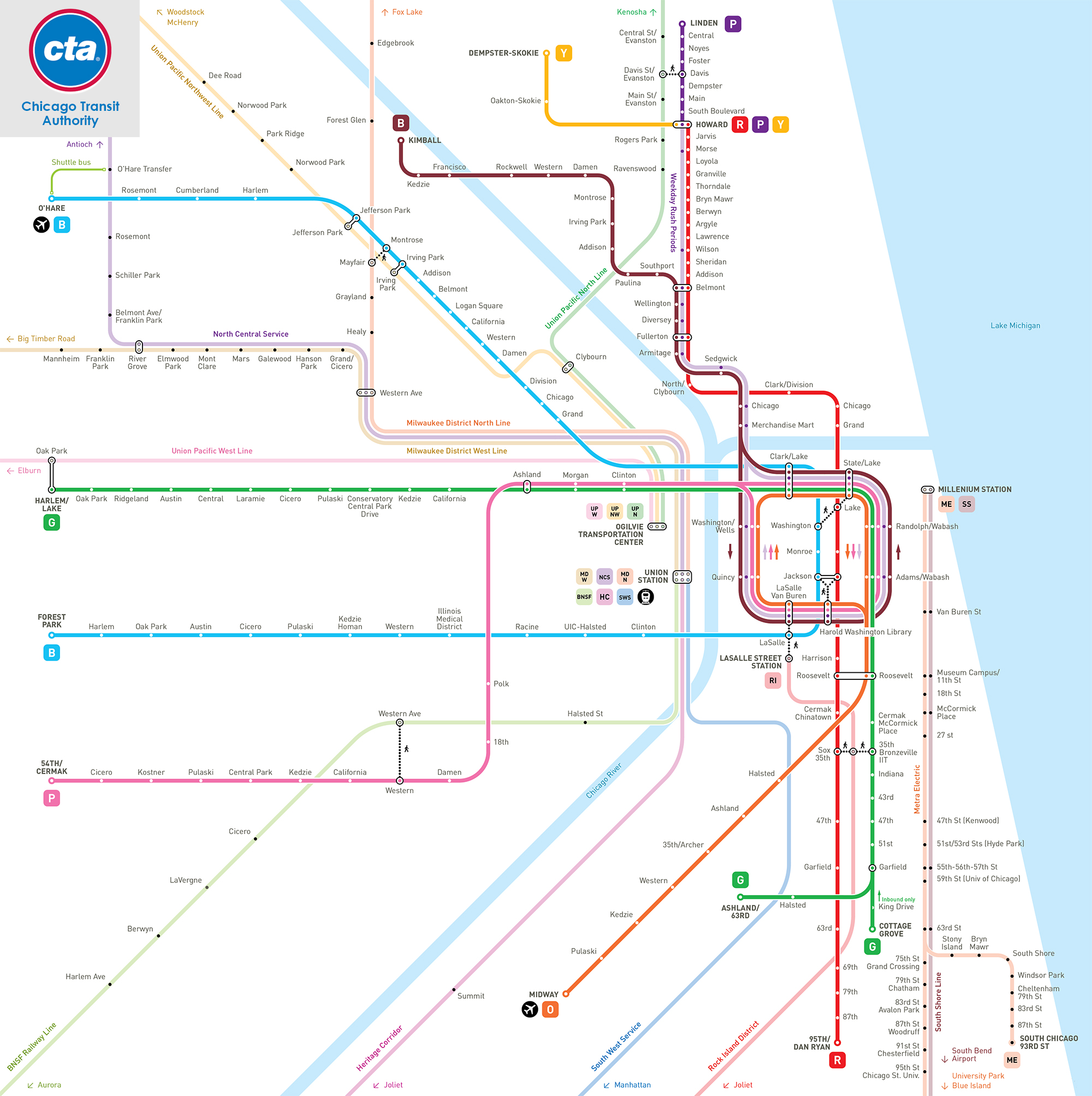
Chicago Metro Map
Map of Chicago L Metro showing different lines. Click on the map to enlarge it or download the Chicago Metro map in PDF format.
Chicago L Lines and Stations
Chicago’s “L” has eight color-coded lines, each with its own route and stations:
Red Line
Runs north–south from Howard (Rogers Park) to 95th/Dan Ryan on the South Side. It has 33 stations along a 23.4-mile (37.7 km) route, with most of its downtown section in the State Street Subway. This is Chicago’s busiest line.
Blue Line
Runs between O’Hare Airport and Forest Park (Oak Park) through downtown. It has 33 stations and covers 26.9 miles (43.3 km), making it the system’s longest line. It runs in the Dearborn Street Subway downtown and on elevated tracks near both ends.
Brown Line
Also known as the Ravenswood Branch, it runs from Kimball (Uptown) into the Loop. It has 27 stations along 11.3 miles (18.3 km). Trains connect North Side neighborhoods to the northwest corner of the Loop.
Green Line
Runs between Harlem/Lake (Forest Park/Oak Park) and two South Side branches: Ashland/63rd and Cottage Grove. It has about 30 stations along 20.7 miles (33.3 km). Green Line trains run on elevated tracks through the Loop along Lake and Wabash. Part of the line includes the 1892 Lake Street Elevated, the first “L” route.
Orange Line
Runs from Midway Airport to the Loop. It is 13 miles (20.9 km) long with 16 stations. The line runs on a dedicated elevated track on the Southwest Side before joining the Loop Elevated downtown.
Pink Line
Runs from 54th/Cermak (Cicero) into the Loop. It has 22 stations along 11.2 miles (18.0 km). The Pink Line uses former Blue Line tracks west of Damen and enters downtown via the Loop Elevated.
Purple Line
Runs from Linden (Wilmette) through Evanston to Howard. Regular service has 11 stations over 3.9 miles (6.3 km). During weekday rush hours, some Purple Line trains operate express service through the Loop using Brown and Pink Line tracks.
Yellow Line
Also known as the Skokie Swift, it runs from Dempster–Skokie to Howard. It has 3 stations along 5.1 miles (8.2 km). The Yellow Line connects Skokie riders to the Red and Purple lines at Howard.
Each line’s major stops and terminals are clearly marked on CTA maps. Most lines intersect downtown in the Loop, allowing free transfers. Clark/Lake Station is a key hub, serving six lines (Brown, Green, Orange, Pink, Purple, and Blue). Transfers between all CTA lines and buses are free within two hours.
Schedules and Frequency
Red Line
Runs 24/7. On weekdays, trains arrive about every 7 minutes during rush hours and every 10–15 minutes off-peak. Overnight (midnight–5:00 am), trains run about every 15 minutes.
Blue Line
Also runs 24/7. Service is every 6–8 minutes during the day and about every 15 minutes at night.
Brown Line
Runs daily from about 4:00 am to 1:30 am (5:00 am–1:00 am on Sundays). Trains arrive every 7–10 minutes during rush hour and every 10–15 minutes midday.
Green Line
Weekday service is about 3:45 am–12:45 am (Harlem–Cottage Grove) and 4:00 am–1:00 am (Harlem–Ashland/63rd). Service ends around 12:50 am in both directions. Trains run every 7–10 minutes during rush hours and every 10–15 minutes off-peak.
Orange Line
Runs from about 3:30 am on weekdays (4:00–4:30 am on weekends) until around 1:00 am. Frequency is 7–10 minutes during rush hours and 10–15 minutes off-peak. No service after 1:00 am.
Pink Line
Runs daily about 4:00 am–1:00 am (starting around 5:00 am on weekends). Trains come every 7–10 minutes during the day and every 10–15 minutes in the late evening.
Purple Line
Local service operates from about 5:00 am to 1:30 am. Rush-hour express trains to the Loop run on weekdays only. Frequency is about 6 minutes in rush hours and 10 minutes off-peak.
Yellow Line
Runs from about 5:00 am to 11:00 pm daily. Trains come every 10–20 minutes, with more frequent service during weekday peak times.
Most CTA rail lines run 18–20 hours a day. Rush-hour trains arrive every few minutes, while midday and evening service is typically every 10–15 minutes. Late-night “owl” service (after midnight) is offered only on the Red and Blue Lines, with trains every 15 minutes. Full schedules and first/last train times are posted on the CTA website and at stations.
Prices, Tickets, Cards and Passes
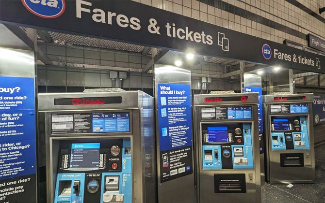
CTA uses the Ventra fare system. A standard single ride on the “L” costs $2.50. Bus rides cost $2.25. Transfers—up to two additional rides within two hours—are free. Unlimited-ride passes are available for frequent riders.
| Fare Type | Price (USD) |
|---|---|
| Single “L” train ride | $2.50 |
| Single CTA bus ride | $2.25 |
| 1-Day CTA/Pace Pass (24h) | $5.00 |
| 3-Day CTA/Pace Pass (72h) | $15.00 |
| 7-Day CTA/Pace Pass | $20.00 |
| 30-Day CTA/Pace Pass | $75.00 |
| Ventra Card (new) | $5.00 (refundable) |
Notes:
- All listed fares are standard adult prices.
- Reduced fares (for seniors, students, and people with disabilities) are about half price.
- A new Ventra Card costs $5, refunded as transit value if registered.
- Ventra Tickets (valid for 3 rides within 2 hours) cost $3, except at O’Hare where they cost $5 due to a premium airport fare.
- Riders using a 1-Day Pass can board at O’Hare with no extra charge.
- Ventra Cards and Tickets can be purchased at station machines, online, or paid with contactless bank cards and mobile wallets at the same rates.
Connections
Nearly every “L” station connects to CTA bus routes, and many link to regional transit. Downtown hubs such as Clark/Lake (Loop) provide transfers to six bus lines (#22, 24, 134–136, 156). Roosevelt Station (Green/Orange/Red) connects to multiple buses (#1, 3, 4, 12, 18, 29, 62, 146) and is three blocks from the Metra Electric and South Shore Line. Major terminals like Midway (Orange Line) connect to many CTA and Pace routes, including CTA #54B, 55/55A/55N, 59, 62H, 63, 165 and Pace #379–390.
Some stations connect directly to commuter and intercity rail. Davis Station (Purple Line) links to Metra’s UP-North trains. From Quincy-Wells, riders can walk to Union Station for Metra and Amtrak services. Nearby, Clinton (Blue/Pink) also provides easy access. Free transfers between CTA buses and trains allow seamless route combinations.
The “L” is fully integrated into Chicago’s wider transit network. Every station connects to at least one CTA bus, many to Pace suburban buses, and several to Metra or Amtrak lines.
Airport Connections
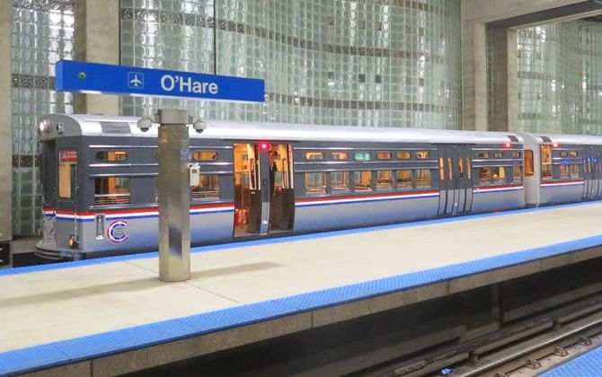
The Blue Line connects downtown to O’Hare International Airport 24/7. The trip to the Loop takes 40–45 minutes. Boarding at O’Hare requires a $5 fare instead of the standard $2.50, but 1-Day passes and Ventra pay-as-you-go cards cover the surcharge. The O’Hare station connects directly to all terminals via walkways and the airport’s Automated Transit System.
The Orange Line runs from downtown to Midway Airport. The trip takes about 25 minutes. Midway Station is next to the terminal, with no extra charge beyond the standard $2.50 fare. Both airports have clear signs, and CTA maps and announcements guide passengers from trains to terminals.
Rules, Tips, and Warnings
No Eating or Drinking. Food and drinks are not allowed on trains or buses. Snacks and beverages are permitted only in stations, where trash bins are provided.
Pets. Only small pets in enclosed carriers are allowed on trains. Service animals are always permitted.
Bikes and Strollers. Bicycles are allowed, with a limit of two per car. Boarding must be done carefully, and bikes may be restricted during rush hours. Strollers are allowed but should be folded if trains are crowded. Strollers cannot be taken on escalators.
Courtesy Seating. Priority seats must be given to seniors, people with disabilities, and pregnant riders. When cars are crowded, use aisle space and let others exit before boarding.
Peak vs. Off-Peak. Rush hours (weekdays about 7–9 am and 4–6 pm) are very busy. Allow extra time for delays or crowded trains. Travel outside these hours is usually calmer.
Safety. Stay behind the yellow line on platforms and hold handrails when boarding. CTA staff patrol stations and trains. At night, stay alert and keep belongings secure. Every station has staff and emergency call buttons. If you see suspicious activity, leave the area and report it.
Payment. Always tap a Ventra card, contactless bank card, or mobile wallet when boarding. On buses, use the front door. Fare evasion is prohibited.
Alerts and Planning. Track work or reroutes may affect service. Check CTA’s website or apps for real-time updates. Most stations have departure boards with live train times.
- Overall, the “L” is easy to use. Maps are posted at stations and inside trains. Announcements give upcoming stops and transfers. For help, ask CTA staff at station booths.
- On some lines, such as the Blue Line, there are two stations with the same name. Check the map before you set off to avoid confusion.
- With the exception of the Yellow Line, all lines run through the Loop, which is a great place to make connections between lines.
- Although the Red and Blue lines operate 24 hours a day, stations can be deserted and potentially unsafe late at night and in the early hours of the morning. Please exercise caution.
History
The Chicago “L” has been operating for more than 130 years. The first segment opened on June 6, 1892, as a steam railroad from 39th Street to downtown. By the late 1890s, new branches such as Lake Street and the Metropolitan West Side had been added. In 1897, financier Charles Yerkes completed the downtown Union Loop, linking the lines into one system.
In 1893, Chicago introduced one of the world’s first electric rapid transit cars at the World’s Fair, using third-rail power—the same technology still in use today. By 1921, the network had taken its present form, with multiple private companies feeding into the Loop. After World War II, the system was consolidated under the publicly owned Chicago Transit Authority (CTA), created in 1945 and taking over in 1947. CTA later opened subway routes under State Street (1943) and Dearborn Street (1951), then expanded to O’Hare in 1984 and Midway in 1993.
Over the years, many older lines and stations have been rebuilt or modernized. The Green Line underwent a major reconstruction in 1994, and most stations today are ADA-accessible. Some tracks from 1892 remain in service, including portions of the Lake–Forest Park branch, highlighting the system’s longevity.
Notable Facts
- Scale
The system has 146 stations, 224.1 miles (360.6 km) of track, and more than 1,560 rail cars. It is the second-largest transit network in the U.S., after New York City.
- Heritage
The Chicago “L” is the second-oldest rapid transit system in the Americas, after New York, and dates to 1892. Its name comes from its elevated structure.
- Ridership
In 2024, CTA rail averaged more than 389,000 weekday riders. The Red Line alone carried nearly 130,000 passengers daily.
- Longest Route
The Blue Line is the longest route at 26.9 miles (43.3 km), running between downtown and O’Hare. Along with the Red Line, it operates 24/7, making Chicago one of the few cities worldwide with continuous rail service.
- Airport Links
Chicago is unusual in having rail service to two major airports. The Blue Line connects to O’Hare and the Orange Line to Midway, offering direct access for travelers.
- Historic Trackage
Sections of the original 1892 South Side “L” are still in use on today’s Green Line, making it one of the world’s oldest continuously operating transit lines.
- Downtown Loop
The downtown Loop Elevated is a 1.8-mile (2.9 km) circuit shared by all Loop-bound trains. Clark/Lake Station, one of its busiest hubs, connects six different lines. Many Loop stations and structures, especially along Lake and State Streets, hold historical significance.
- Fleet
CTA operates 1,564 rail cars, all built for compatibility across lines. Most trains run with up to 8 cars.
- Park-and-Ride
Several stations on the system’s edges, such as Dempster–Skokie (Yellow Line), Cicero (Pink Line), Midway (Orange Line), and Harlem (Blue Line), provide large commuter parking lots.
- Record Traffic
The busiest ridership days occur during major events, such as World Series games or holidays. On game days, especially after Cubs or White Sox games, trains can be extremely crowded.
Future Expansions
CTA’s main rail expansion is the Red Line Extension (RLE). This project will extend the Red Line 5.5 miles (8.9 km) south from 95th Street to 130th Street, adding four new stations at 103rd, 111th, Michigan Avenue, and 130th. Construction is underway and will greatly improve service to the far South Side.
Other concepts have been discussed, including a downtown “Circle Line” that would connect all CTA and Metra lines in the city center. However, this remains in preliminary study and is not part of current regional plans. CTA is also modernizing existing stations, focusing on accessibility upgrades through its All Stations Accessibility Program. Aside from the RLE, no major new lines are imminent; the focus is on upgrades, maintenance, and possible bus rapid transit projects.
Sightseeing Via Metro
Many of Chicago’s top attractions are accessible by the “L,” sometimes with a short bus or walk:
- Downtown/Loop: Millennium Park, the Art Institute, the Theatre District, and State Street shopping are all within the Loop. Multiple lines converge here, and most Loop stations are just blocks from attractions.
- Navy Pier & Magnificent Mile: Take the Red Line to Grand or Chicago stations. From there, it’s a short walk to the Magnificent Mile. CTA buses #29 and #65 connect downtown to Navy Pier.
- Chinatown: Ride the Red Line south to Cermak–Chinatown Station, which exits directly into the district.
- Garfield Park Conservatory: Take the Green Line west toward Harlem and get off at Conservatory–Central Park Drive Station. The conservatory is a short walk away.
- Guaranteed Rate Field (White Sox): From downtown, take the Red Line south to Sox–35th Station or the Green Line to 35th–Bronzeville–IIT. The stadium is right next to the stops.
- Wrigley Field (Cubs): Take the Red Line north to Addison Station. From there, it’s one block east to Wrigley Field.
- McCormick Place: Served by the Green Line at Cermak–McCormick Place Station, next to the convention center.
- Shedd Aquarium, Field Museum, Skydeck: From Roosevelt Station (Green/Orange/Red), walk through Grant Park or use CTA bus #146 (seasonal #130/146 during summer).
- Lincoln Park Zoo and Museum of Science & Industry: Not directly on the “L.” Use Red or Brown Line stations (Fullerton or Roosevelt) and transfer to buses.
Other neighborhoods such as Lincoln Park, Wicker Park, and Pilsen are also near “L” stops. CTA provides a sightseeing map on its website to help tourists plan. For visitors, the “L” is an affordable way to explore the city, with quick connections to downtown, many cultural sites, and both airports. Free transfers and day passes make sightseeing even easier.